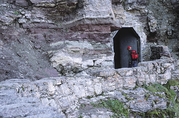
A hiker enters the Ptarmigan Tunnel. Photo Bert and Jane Gildart
43 Ptarmigan Tunnel
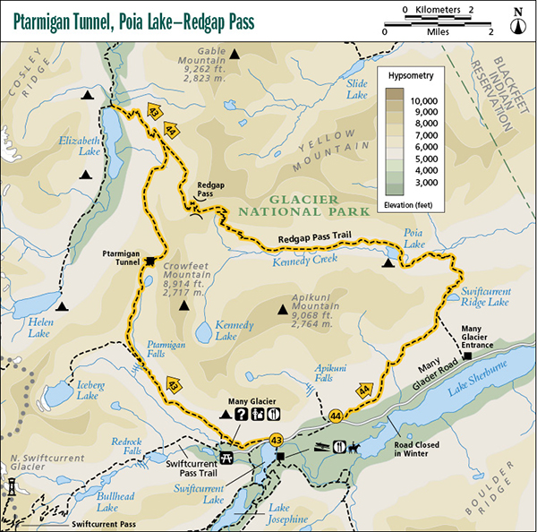
A day hike from Swiftcurrent Inn to Ptarmigan Tunnel, 5.0 miles (8 km) one-way; or a backpack from Swiftcurrent Inn to Elizabeth Lake foot, 9.8 miles (16 km) one-way.
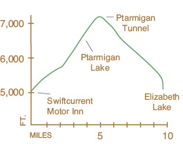
Elevation gain: 2,480 feet
Elevation loss: 2,518 feet
Maximum elevation: 7,200 feet
Topo maps: Many Glacier, Gable Mountain
Finding the trailhead: The Iceberg-Ptarmigan trailhead is located at the north end of the Swiftcurrent Motor Inn complex (at the end of the Many Glacier Road), among the cabins behind the coffee shop. Trailhead GPS: 48.799744 / –113.679291
The Hike
The spectacular views and only moderate difficulty of the Ptarmigan Tunnel Trail make it a preferred route among local hikers accessing the Belly River drainage. The trail passes from Swiftcurrent Inn up the Wilbur Creek Valley, turning northward past Ptarmigan Lake. High above the lake, the trail passes through a knife-edge ridge and descends to the foot of Elizabeth Lake, after covering a distance of 9.8 miles. The Ptarmigan Tunnel itself may be a day-hike destination from the Many Glacier area as well as an access point to the Belly River country. The tunnel is subject to seasonal closures due to snowdrifts and occasional grizzly bear presence; check at the Many Glacier Ranger Station for trail status.
The route to the Ptarmigan Tunnel begins at Swiftcurrent Inn and follows the Iceberg Lake Trail around the south slopes of Altyn Peak to a trail junction at mile 2.5. At this point the trail to Ptarmigan Tunnel takes off to the north, ascending through open woodlands to the foot of Ptarmigan Lake, which lies in a gravelly, barren-looking cirque below the tunnel. After a short but challenging ascent, the trail reaches the tunnel, which was blasted through the solid rock of the Ptarmigan Wall in 1931. Looking southward from inside the tunnel, Mount Wilbur is framed by its massive steel doors. After emerging from the north side of the tunnel, you will see Elizabeth Lake in the valley below, with Natoas Peak rising above it.
A hiker enters the Ptarmigan Tunnel. Photo Bert and Jane Gildart
The best views on the entire trail are only 0.5 mile north of the tunnel, around the east wall of the barren cirque below. From this view point the twisted spires of Mount Merritt can be seen rising above the Old Sun Glacier, and to the southwest, Helen Lake can be seen nestled at the foot of Ipasha Peak.
The trail continues its descent among stands of twisted whitebark pines to a junction with the Redgap Pass Trail some 2.4 miles beyond the tunnel. From this junction it’s only 2.0 miles of descent through mixed forests to a suspension bridge that crosses the Belly River into the Elizabeth Lake (foot) Campground. The campground overlooks the fish-laden lake, with views of the cockscomb of the Ptarmigan Wall, through which the hiker has just passed.
Miles and Directions
0.0Trail sign.
0.1Junction with Iceberg Lake Trail (#167). Turn left for Ptarmigan Tunnel.
2.4Trail crosses Ptarmigan Creek at Ptarmigan Falls.
2.5Junction with Ptarmigan Tunnel Trail. Turn right for Ptarmigan Tunnel.
4.1Ptarmigan Lake. Trail ascends steeply to the tunnel.
5.0Ptarmigan Tunnel. Trail begins descent into Belly River Valley.
5.4Best view of Mount Merritt to the north.
7.8Junction with Redgap Pass Trail. Stay left for Elizabeth Lake.
9.8Elizabeth Lake.