
Giant dune, Athabasca Sand Dunes.
Saskatchewan’s Athabasca Sand Dunes
Giant dune, Athabasca Sand Dunes.
We're travelling a narrow ribbon between two vastly different worlds. The east bank of the river is clothed in dark green jackpine forest typical of northern Saskatchewan. But on the west side, all we see is massive banks of golden sand, in places rising more than 30 metres straight out of the water. When we pull our canoe into shore and struggle to the top of the banks, the sand stretches west as far as we can see. We're overlooking the largest sand dunes in Canada, and the largest this far north anywhere in the world.
We've returned to one of our favourite places on Earth – the William River flowing through the Athabasca Sand Dunes. Of all the spectacular landscapes we have visited around the world, Athabasca remains the most special for us. It was our earlier travels here that were responsible for a major shift in our lives, leading to a career in book publishing.
During our first trip to the dunes, we were on assignment for Canadian Geographic magazine to write an article on this mostly unknown and little-visited landscape. Most of our travel writing and photography until then had been geared toward magazines and newspapers, but we were so taken with Athabasca that we were convinced that articles were not enough. These fascinating dunes needed an entire book. So after a few return visits to explore further and round out our photography, we published our first book – Northern Sandscapes – Exploring Saskatchewan's Athabasca Sand Dunes. It turned out that the timing was right for the book. The Saskatchewan government had just completed extensive scientific studies on the dunes, then protected the area in a new provincial park. People were curious to see what all the fuss was about.
These are among the most unusual of the world's great dune fields. As we might expect, the biggest sand dunes are normally found in deserts or at least in dry climates. But not here. It's as if a chunk of a desert-like terrain had been picked up and plopped right in the middle of northern Canada's boreal forest and lakelands. The dunes border the ninth largest lake in North America, the fourth largest lake entirely within the borders of Canada. Three rivers slice right through the dune fields, something we don't expect to find in either northern forest or sand dunes. It's this surprising though delightful mix of sand, water, and trees that makes these dunes spellbinding.
The Athabasca Sand Dunes are practically in our back yard, about 800 kilometres north of our home in Saskatoon. Yet, this is one of the more difficult places to reach. It's actually more straightforward to travel to the dunes in the Namibian desert on the other side of the globe; fly to Namibia or South Africa, rent a car, and simply drive to the park. The Athabasca Sand Dunes have no road access, which is fortunate because the lack of easy access is helping to preserve this fragile landscape. On the other hand, it's quite challenging to visit. Once you arrive, there are absolutely no facilities of any kind – no scheduled transport, no shops, no accommodation or campgrounds, no buildings, no people, no cell service. Our kind of place.
The only options are to fly in or go by boat, and even these aren't easy. Stony Rapids is the only community on Lake Athabasca with road access, and that's a long, rough bone-jarring journey. Stony Rapids is at the extreme east end of Lake Athabasca, while the main dune fields are close to 200 kilometres farther west. It is possible to travel by boat from communities on Lake Athabasca, but crossing this expansive lake is like travelling on an inland sea, where huge waves are often the rule. The south shore along the dunes is also wide open, with no islands, no deep bays, and nowhere to hide in a storm or big waves. Motor boats have a tough time landing on the shallow, sand-choked shore. Depending on water levels, sandbars often extend far out from the lakeshore. And there's been accidents. A landmark on the beach in Thomson Bay is an old rusting tank, a remnant from a barge that broke up in a storm many years ago. Float planes can land on the water and drift in to shore, but only if the winds and water are calm enough. That's a big “if”.
The first time we came here was by canoe, travelling down the William River. We drove to the end of the road in northwest Saskatchewan, which ends on a rough mining exploration road at Carswell Lake. We paddled to the northern reaches of Carswell Lake, then made a short portage into the north-flowing Carswell River. Several times we ran aground on this extremely shallow river, and had no choice but to pick up our gear and carry it to deeper water. Things changed when the Carswell emptied into the much bigger William River. There's more water, but also more rocks and rapids. Our main memory of that trip was of one big rock garden, where we were constantly dodging boulders and picking our way through rocky rapids.
We knew we were getting close to the dunes, but when we rounded a bend and saw them for the first time, it still came as a surprise – a golden wall of sand lining the west bank. That dune stands all by itself, as if stranded away from the main dune field.
After a short paddle, we hit the widespread William River Dune Field. For the next 25 kilometres, we travelled along this strange narrow ribbon, with familiar forest on the east bank, and gigantic walls of sand on the west.
Never have we seen a river change its character so completely as the William. For most of its course, this stony river is defined by rocks, rocks, and more rocks. About 18 kilometres before the river's end, there's one last flourish of frothing rapids plunging over rocky shelves, framed by car-sized boulders. Then suddenly it's as if we emerge into an entirely different river. The sand takes over, choking the river and spreading it into a wide braided stream, up to a half kilometre wide in places. There isn't a rock in sight, hardly even a tiny pebble. It stays like this all the way to Lake Athabasca.
It becomes even wider as the sand-choked delta of the William fans into Lake Athabasca, with a myriad of shallow channels shooting sand far into the lake. Sandbars are everywhere, mixed with low islands where vegetation has taken hold in the semi-stabilized sand. On our first trip, we canoed, or rather tried to canoe, through the main delta. The water got so shallow that eventually we had to forget about paddling and walked, trying to keep the canoe afloat in water only inches deep. It felt peculiar walking far into that immense lake in ankle-deep water. Fortunately, the lake was uncharacteristically calm.
This time, we're planning on canoeing upstream on the William River as far as the end of the rapids, a trip we have done three other times over the years. Our pilot Cliff Blackmur from Athabasca Fishing Lodges flies us in his Single Otter float plane over the lower stretches of the river then circles the delta. We look down at one of the most remarkable sights anywhere. The William River is full of surprises, but saves its grand finale for those who fly over the braided section, which now magically becomes a gigantic abstract painting. Multi-hued shades of gold, beige, and copper reveal varying depths of underwater sandbars, while above water sandbars appear alabaster white, and deeper channels are chocolate brown. The overall effect of the swirling colours looks like butterscotch pudding marbled with whipped cream.
Cliff brings the float plane down near the mouth of a narrow creek that branches off the William River just before the delta. But even this smaller waterway spews an amazing amount of sand into the lake, forming its own delta just around the point from the main delta. We land well over a half kilometre from shore in water that is barely a foot deep. Cliff is concerned that the plane might drift into the sandbars and become stuck, so we waste no time untying the canoe from the pontoons of the plane and throwing in our gear. As we paddle away, Cliff immediately starts the plane and quickly gets airborne. As with most canoe trips we have taken in the north, we consider this the real start of the journey – when the pilot leaves and we're completely on our own in the wilderness.
Paddling upstream in a strong current is challenging at the best of times, but in these shallow conditions our paddles often hit ground and we have a hard time getting enough power. A trick for paddling in shallow water is to “pole”, pushing on the river bottom with your paddle. But here, the unstable sandy bottom is forever moving, up to 10 metres a day scientists tell us, so usually it's like pushing into mush. Our progress is slow; many times a promising-looking channel simply ends, and we run aground. We're only travelling 18 kilometres upstream, but in reality it's a lot more than that since we continually zigzag across the wide river, trying to stay in the deeper channels.
After a day and a half of steady paddling, we reach the end of the rapids. This is our favourite spot in the entire dunes. Sand banks lining the west side are met by a tongue of sand on the east bank from the extensive Thomson Bay Dune Field that stretches all the way to the lake. At this spot, the dune fields come together, almost overwhelming the river that separates them.
The partially damp dune slacks just back of the west bank are ideal for many rare plants. Protecting the unique plant life of the Athabasca Sand Dunes was a principal reason for establishing the provincial park. In fact, botanists consider this among the most important places in Canada for the study of rare plants. Over 50 species are considered rare, and some are endemic, growing nowhere else on Earth. When the park was created, 10 endemics had been identified. More recently, the number most often used is eight, since a very small number of a couple plants have tentatively been identified in other places. In any event, these are extremely rare plants.
The features of some are so esoteric that only botanists could get excited, but many are obvious to even a casual observer. Among the most widespread is the felt-leaved willow, with fuzzy bluish-green leaves that have the look and feel of felt. Sand chickweed is a low growing plant with delicate, minuscule white flowers at the end of thin stems. Yet this fragile-looking plant is so tough that it seems to thrive in pure sand. The most intriguing is the Athabasca thrift. Recognized by its distinctive round head with a cluster of little pink flowers sitting atop a long stem, it’s like a miniature candy apple stuck in the sand.
It's not only rare plants that make this region so special. Early in the summer, the sand is carpeted in yellow with blooming sand heather. We find bright pink stemless ladyslippers in various parts of the north, but nothing like here. In some forested areas bordering the dunes, the ladyslippers are so thick that it's difficult to walk between them. On our way up the river, we stop at a willow-covered island for lunch. The sandy ground appears to have a reddish tinge, and when we look closer, we find thousands of oblong-leaved and round-leaved sundews that derive nutrients from absorbing insects trapped in sticky dew on hairs projecting from their leaves. A common though bizarre sight is exposed tree roots that are up to three metres above ground; over the years winds have blown away the supporting sand, undermining many trees.
The end of the rapids is also the perfect jumping-off point to visit Athabasca's magnificent giant dunes. The William River Dune Field is about 15 kilometres across. Near the centre stand 40 or so giant dunes, some over a kilometre long and 35 metres high. They aren't visible from the river. All we can see is an endless expanse of sand, gradually rising toward the horizon. It takes a couple hours to walk to these dunes. As we start out it's a bit disconcerting heading into a sea of sand. After a half hour or so, we gain enough altitude to see the monsters looming in the distance. While the direct distance to the first big dune is only about five kilometres or so, it takes so long because we have to weave a circuitous route around the expanses of desert pavement, the most fragile feature of the dunes. The wind has winnowed away the top layer of sand, leaving slightly heavier pebbles sitting on top. If we were to step on this formation, our footprints would be visible for years.
We take our time wandering along the edges of the desert pavement looking for ventifacts, strange Brazil-nut shaped stones that have been sandblasted for thousands of years. While sandblasted rocks are not unusual, what's peculiar about these is that they have been blasted from two different sides. Prevailing winds come from the northwest today, but the speculation is that winds came from a different direction thousands of years ago, accounting for the rocks' sharp angular formation. When researching our Northern Sandscapes book, we talked to two German scientists who had studied ventifacts throughout the world. They said that those of Athabasca were the most well defined specimens they had come across anywhere.
It is only practical to hike to the giant dunes in relatively calm weather. More than once, we have started out from the river, only to be forced to turn back when winds whipped the sand and filled the air. Blowing sand can make short work of camera gear in these conditions. It's not so great for our eyes either, and our exposed skin soon feels like coarse sandpaper. We usually set out on the hike in early evening since there's a better chance that winds will abate later in the day. Plus there's the added bonus of enjoying sunset on the big dunes, which comes around 10:30 in mid-summer – an unforgettable highlight of this unique area.
We notice a variety of animal and bird tracks on the dunes just back of the river. But less than 500 metres into the dune field, the tracks disappear. The only sign of birdlife is a few Arctic terns, which sometimes nest on the desert pavement. They watch us carefully, screaming and scolding us for passing through their territory. This area marks the southern reaches of their nesting range in mainland Canada.
Plantlife thins out very quickly as we move farther into the dune field, but even around the big dunes, clumps of sea lyme grass dot the landscape. This tall robust grass normally grows in maritime areas of Canada. It is rare in Saskatchewan, except in the dunes, where we see it almost everywhere.
From a distance, the dunes appear long and undulating, like humpback whales in a sea of sand. When we arrive at one of the larger ones, it rises straight up from the level floor of the dune field. Strong winds from both east and west have sculpted the dunes, creating curving knife-edge crests. The sand feels reasonably solid as we walk along the level dune field, but as soon as we start climbing, we struggle and sink ankle deep with every step. Near the top, the dune becomes increasingly sharp, with a gradual slope to the west and a more precipitous drop to the east.
Sitting on top, we look over a series of other dunes stretching to the northwest, while to the north lies Lake Athabasca, and in the east we see a faint green line marking the east bank of the William River valley. As the low sun gradually dips in the west, the dune is transformed. The eastern side is thrown into deep shadow, while the sun-facing west slope turns from sandy yellow to rich shades of gold, then right at sunset it's painted with tinges of red.
Since we're almost always surrounded by sand, it's easy to see what critters have been wandering around. Tracks cover the beaches and dunes, giving the impression that wildlife is abundant. Moose, bear, caribou, wolf, rabbits, and a wide array of birds all leave their calling cards. Some of the most extensive networks of tracks belong to the Canadian toad, which wanders across the sand looking for tasty insects.
Seeing tracks is easy, but coming across the animals that made them is another matter. We have only seen a wolf once in the dunes, although we always see plenty of tracks. They go out of their way to avoid us. One morning we followed fresh wolf tracks that came along the water right toward our tent. Once the wolf had climbed the ridge to where our tent was visible, it suddenly changed direction, making a wide circle around our camp before continuing on.
One evening we hear sudden running behind our William River camp, then splashing in the river. It's a woodland caribou, running through the shallow water and across the low sandbars, apparently in an attempt to escape the clouds of mosquitoes. It finds a sandbar in the middle of the wide river and lies down for a welcome rest. Next day we see another caribou, as well as tracks in the sand showing that one has a young calf. These are thrilling though rare sightings. This iconic animal, portrayed on Canada's 25-cent piece, is quickly vanishing across Canada's boreal forest. Officially listed as “threatened”, the woodland caribou is in serious danger of disappearing due to loss of habitat and increasing industrial development.
This is prime black bear country. They have wandered into our camps, but usually if we make enough noise, they will quickly move on. We know plenty are around because we see their tracks everywhere. One time while camping near the shore of Lake Athabasca, strong waves pounded the shore throughout the night, making it difficult to hear anything else. Next morning, we found fresh bear tracks right outside the tent. The bear was obviously curious enough to nose around, but fortunately didn't bother us. The only time we had serious concerns was at a sandbar campsite beside the William River. While eating supper, we glanced up to find the biggest black bear we have ever seen come out of the bush and walk straight toward us. We managed to scare it back into the forest, but it went slowly and reluctantly, as if to say “Okay, I'll go...for now.” Right after supper, we packed up and moved our camp farther downriver.
The oddest bear encounter was also on the William. We were paddling downstream on the wide braided section, trying to stay in deep enough water in a fairly narrow channel. Just ahead, a bear came out of the thick bush on shore and started swimming across the river, without checking for traffic. We were headed straight for it. If we tried to veer off, we would likely get hung up on a shallow sandbar next to a surprised bear. On the other hand, running into a bear didn't seem too smart either. Just before we had to decide what to do, the swimming bear glanced our way. Its eyes practically popped out of its head as it did a quick flip and in a flash swam back to shore as we glided past.
The only critter to ever cause us problems was one moose. We encounter a lot of moose in our northern travels. If they see us at a distance, they may cautiously continue feeding, while keeping an eye on us. But if we're too close, almost every time moose will immediately flee. On our most recent trip, an adult moose and calf ran right beside our tent early one morning. Likely they were walking along, caught sight of our tent, then realized that something was out of the ordinary and decided to hightail it.
Things don't always go according to plan. One time we paddled downstream on the narrow creek that runs off the William River. The current was so strong that we simply had to steer along the twisting waterway. We rounded a sharp bend and suddenly came face to face with a big bull moose standing in the water. Not making any noise, we had surprised it. Instead of fleeing as most moose would do, he charged us. We looked up at his long legs splashing through the shallow water, his head down and aimed at the centre of the canoe. He hesitated for a split second and was almost on top of us. Robin swung his paddle and we heard a loud crack as the paddle caught the moose squarely on the end of his nose. The moose stopped just long enough to shake his head and try to figure out what to do next, while we paddled like mad to put some distance between us and the bad-tempered moose.
We're about to travel that same stretch again, as we leave our idyllic sandbar camp spot near the end of the rapids and head down river. The same section that was such a struggle to paddle upstream a few days earlier now takes us on a fast downstream joyride. Fortunately, this time we don't meet any cantankerous moose. Winds are picking up, and closer to the delta we can see waves crashing on the shore. There's no choice but to wait it out. The narrow creek is lined in thick bushy willows and shrubs, somewhat reminiscent of an impenetrable tropical stream. Near the mouth we find a section of level, semi-open jackpine forest right next to the water, the perfect spot to set up camp. We might as well settle in, since winds continue to howl away well into the evening.
We wake up at 4:00 the next morning with the intention of travelling to our favourite camping spot in Thomson Bay before the winds and waves arrive. As a general rule, winds are calmer in evening and early morning, but we've had enough experience with this lake to know that it plays by its own rules, doing what it likes when it likes. But this time we're lucky to paddle into the lake in near dead calm conditions. We've had forest fire smoke over the past few days, some from nearby fires and some drifting in from hundreds of kilometres away. With no wind, the smoke blankets the water like a shroud. Visibility is fine along the shore, but looking into the lake, the smoke partially obscures the rising sun, while the horizon disappears as the water and sky meld into a surreal steely grey.
We're struck by how dramatically different Lake Athabasca's south shore is from the north shore. The north is classic Precambrian Shield country, with rocky outcroppings, high granite cliffs, a labyrinth of islands, and deep bays. Some of the bays are so big that they are more like separate lakes. We've travelled much of the north shore by motor boat. Waves and storms can batter this shoreline as well, but we can usually find somewhere sheltered to wait it out.
While the south shore has nowhere to hide to escape nature's fury, we feel safer here in a canoe than in a motor boat. We're able to negotiate the extremely shallow water near shore. With the exception of a few stretches, non-stop beaches line the 100 kilometres or so of lakeshore in the sand dunes section. So when things get dicey, as they inevitably do, we can quickly pull into shore, drag the canoe up, and wait it out, sometimes for an hour or two, sometimes for several days. On one trip, we were stuck in the same spot for close to a week as relentless winds and pounding waves kept up day after day. Even after the winds calmed down, the momentum of the waves continued for an incredibly long time.
Our favourite spot along the south shore is the exhumed forest of Thomson Bay. Several ancient tree trunks, perhaps centuries old, stick out of the pure sandy slope overlooking the bay. It was a normal forest at one time, but was buried by sand as the dunes continued their steady eastward migration with the prevailing winds. Many years later, the winds pushed the sand even farther east, and began uncovering the age-old trees which have been desiccated, looking like petrified wood. Scattered among the remnants of still upright tree trunks are overturned dried roots, many resembling mythical sea serpents with octopus-like tentacles.
Fascinating at any time of day, in evening it becomes an enchanted forest. In mid-summer, the sun sets over the widest part of Lake Athabasca, dipping into the water with no land in sight. As it hangs over the great lake, the low sun shines slightly up toward the exhumed forest, bathing everything in a radiant glow. The ghostly sentinels take on a new character, their bare wooden shapes turning almost blood red with the sun's last rays.
According to a local Dene legend, this was once the land of giants. A giant hunter once threw a spear at a giant beaver that had built a huge dam on Lake Athabasca. Thinking he had killed the beaver, he tossed it onto the south shore of the lake. But the beaver wasn't quite dead, and it thrashed around to such an extent that the shore was ground into sand. Scientists tell us less colourful stories – about glaciers retreating some 9,000 years ago, and meltwater flowing through spillways such as the William River, depositing sandstone sediment in a delta in Glacial Lake Athabasca. As the lake receded and the land rebounded after the weight of the glacial ice was gone, the sand was exposed and whipped into dunes by strong winds.
Sweeping in a 25-kilometre arc just east of the William River delta, Thomson Bay has the largest dune field bordering the lake. But there are a lot more. Another 60 kilometres or so to the east, the Archibald River flows into Lake Athabasca after cutting through forest and sand. The effect is similar to that of the William River, with the east bank clothed in forest and the west bank covered in sand. The narrow river almost becomes lost, sandwiched between towering dunes and tall trees.
The eastern end of the dunes is marked by the MacFarlane River, the biggest and longest river in the park, bringing 11,000 tonnes of sand per day into the lake. This is a wild whitewater river for most of its length, with the last rapids ending about seven kilometres from the mouth. We're able to paddle upstream that far, first along the twisting meanders near the delta, then beside dunes lining the water for a short distance, and eventually to where the river spreads into a picturesque lake about two kilometres across. We're treated to yet another “room with a view” as we camp on a ridge overlooking forested hills, sand dunes, sandstone cliffs, and fingers of rapids spreading around willowy islands.
When Cliff first flew us into this area, he took us over a set of three beautiful waterfalls upstream from the little lake. Now we're anxious to see them up close. We decide to hike there, but the route isn't direct because of boggy terrain and canyons next to the water's edge. It's necessary to go back to the forested ridge overlooking the valley. Forest fires burned much of this area over the years, leaving a maze of deadfall looking like a jumble of pick-up sticks, with new growth so thick that it's often difficult to get through. Our all-day hike turns out to be a tough slog, but when we arrive at the falls, it all seems worthwhile. Framed by thick forest, boulders, and jagged bedrock, the river drops over a series of ledges of varying heights, forming a complex of picture-perfect cataracts rather than a single drop. Above all, it's a rare privilege to be in a place that very few people have ever visited.
So far at least, isolation has kept this special corner of the globe mostly intact. But these days, isolation can be fleeting. Lake Athabasca is downstream from the expansive and controversial Athabasca tar sands development along the Athabasca River. The entire Athabasca Basin, and especially the land south of the lake, is home to the world's richest uranium deposits, as well as some of the world's largest uranium mines. Mining exploration reached feverish levels a few years ago, but has since eased off somewhat in the aftermath of the Fukushima nuclear plant disaster in Japan, as many nations pause to reconsider the “benefits” of nuclear power. We can only hope that the land of the giant beaver will continue to weave its magic for years to come.
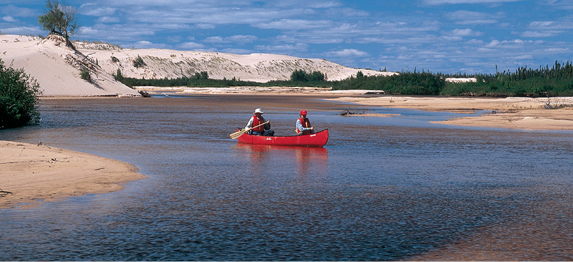
Unlike the dry desert dunes of Namibia, the dunes of Athabasca are sliced by rivers such as the William.
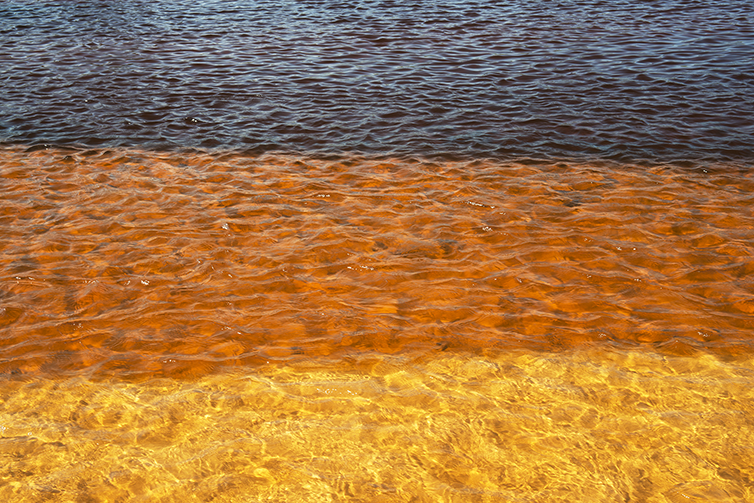
Sand at varying depths forms the riverbed of the William.
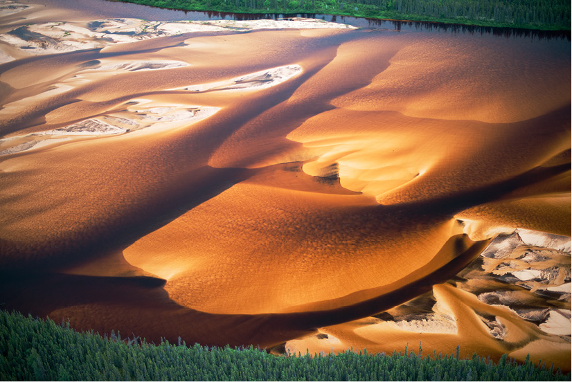
The William River seen from the air. The varying depths of sand on the riverbed give the look of butterscotch pudding marbled with whipped cream.

The exhumed forest of Thomson Bay is bathed in a red glow as the sun sets over Lake Athabasca.