Chapter 10
Soil Conservation and the Environment
Conserving the soil has become increasingly important as the need for food and fiber continues to increase. Producers of food and fiber became more aware in the mid-l900s of the need to conserve their most precious resource. Now the public has become more and more aware of the need. And awareness will continue to grow.
Degradation of soil worldwide is apparent. Awareness of this problem is increasing. Those concerned with proper land use and sustained production have called attention to this problem.
Related to both conservation and degradation are environmental concerns. The public has seen the consequences of a lack of conservation resulting in not only the degradation of soil but also the increased detrimental aspects of soil erosion such as pollution, water quality problems, and so on.
Erosion Processes
If rains are gentle on native grasslands and forests, the water soaks into the soil and percolates downward through the soil profile. If there is enough rain, it eventually drains to the water table. When rain falls faster than the soil can absorb it, some water soaks in and the rest runs over the soil surfaces to the lowest part of the field and eventually runs off. The runoff water from vegetated land may look clear, but it is actually carrying some mineral and organic matter derived from exposed soil, earthworm casts, and the digging activities of ants, moles, badgers, and similar organisms.
This process represents normal or geologic erosion. In some places, geologic erosion may lower the ground surface only an inch (2.54 cm) in 5,000 years. This is probably a normal rate for hills and valleys to form. In desert areas where vegetation is sparse and rainfall is infrequent, the rate of erosion is normally slower partly because many desert soil surfaces are often coarse-textured and armored with a layer of pebbles. Geologic erosion includes landslides that occur in mountainous areas as well as the collapse of riverbanks into floodwaters during periods of excessively high rainfall. Geologic erosion is an ongoing process whereas accelerated erosion occurs due to human activities that increase erosion rates. This chapter addresses the impacts of humans on accelerated erosion processes.
In areas where a protective vegetative cover is normal—such as is common in prairies and forests—erosion losses are minimal. Unfortunately, it is usually human activities that cause accelerated erosion due to the removal of vegetation by tillage or overgrazing by livestock. Most agricultural systems tend to accelerate erosion, but it is the obligation of those who manage farms, ranches, and forests to keep erosion to a minimum. High erosion losses degrade streams and rivers, the source of approximately 75% of the drinking water in the United States. This sediment not only impacts aquatic organisms, but also it is a major cost for water treatment plants to remove the sediment prior to water treatment.
European immigrants to the United States cleared the native vegetation to make cultivated fields. Their livestock often overgrazed rangelands, which weakened the plant cover and compacted the soil. As a result, the original condition of the soil deteriorated rapidly and erosion intensified.
The word erosion literally means gnawing away. In regions where the soil parent material is loose, such as where there is thick loess or glacial till, the long-term effects of erosion are serious but not as devastating as where solid bedrock is the parent material (Fig. 10.1). The latter includes most of the earth except for the valleys, which have been filling with sediment over millions of years.
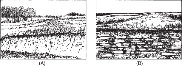
Figure 10.1 Loose substratum (A) slowly develops into soil if surface erosion takes place at a slow rate. Where soil is thin over bedrock (B), erosion of the surface leaves a barren landscape.
Soil erosion is a serious problem on much of the world's cultivated land (Fig. 10.2). A look at most large rivers shows us they carry a heavy load of sediment that comes from watersheds. A watershed is all the land area that yields water from rain and snow to a particular river. A watershed need not become a “soilshed” too. In arid regions where vegetation is sparse and rains are quite often intense, erosion may be severe without human involvement.
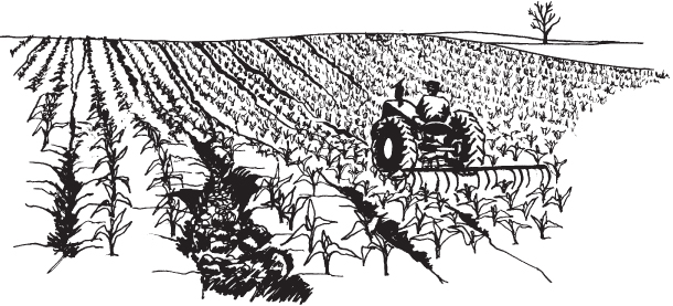
Figure 10.2 Agricultural systems commonly accelerate erosion.
Erosion by Water
Both water and wind erosion consist of three processes: detachment, transportation, and deposition. Soil erosion by water occurs when particles are loosened (detached) and carried (transported) by moving water. The soil particles are eventually deposited. As long as soil particles are clustered into aggregates, they are not easily moved. But if the soil is exposed to the bombarding force of raindrops, the aggregates tend to break apart and the detached particles are subject to movement in the runoff water (Fig. 10.3). Soil aggregates are important to water infiltration and runoff. When the aggregates break apart, the smaller particles plug the larger soil pores important to infiltration. Keeping crop residues on the soil surface protects these aggregates which keep the soil pores open resulting in higher water infiltration rates. As soon as the water infiltration rate is less than the rainfall rate on the soil, runoff occurs.
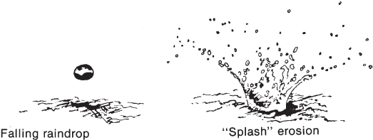
Figure 10.3 The impact of raindrops contributes to erosion by breaking up soil aggregates and splashing soil downslope.
It has been calculated that the rate of fall of a raindrop is about 20 miles (32 km) per hour. The kinetic energy generated by a 2-in. (5-cm) rain on 1 acre (0.46 ha) is about 6 million foot-pounds (4.4 million joules). This is enough energy to raise a 7-in. (18-cm) layer of soil 3 ft (0.9 m). Clearly, this is not all used to move soil, but it does show that the impact of raindrops releases a large amount of energy that contributes to soil detachment and erosion. On a 10% slope, 60% of the soil splashed by raindrop impact moves downslope and only 40% is thrown upslope. The net movement downhill is called splash erosion.
Types of Water Erosion
The main types of water erosion are gully erosion, rill erosion, sheet erosion, and stream bank erosion.
Sheet erosion is the planing off of a land surface by water action without formation of channels. This generally happens where there is not enough cover of vegetation over the soil to prevent erosion but enough to prevent rilling. Sheet erosion is often unnoticed because only a few millimeters of soil may be lost each year. One way to determine the sheet erosion rate is to find an exposed soil surface and look for a small pebble on the top of the soil. If the pebble is setting on a pedestal, the sheet erosion rate can be determined if one knows when tillage last occurred.
Rill and sheet erosion also often go unnoticed because tillage destroys the evidence until most of the topsoil is gone and the subsoil is exposed at the surface. Although less spectacular than gully erosion, rill and sheet erosion cause the loss of a great deal of more soil.
The most spectacular type of water erosion is gully erosion, which occurs when water concentrates in a channel and deepens it rapidly (Fig. 10.4). Usually a gully is defined as a channel so deep that farm equipment cannot safely cross. This is what happened over a long period to the Grand Canyon of the Colorado River, and it is happening on a smaller scale on thousands of farms throughout the world. A gully generally starts at the outlet of a channel and works its way upstream by waterfall action at its head. The gully extends itself upstream by undercutting the floor of the channel. On a larger scale, Niagara Falls is also working its way upstream, as shown by the occasional fall of masses of limestone bedrock from the rim. By contrast, rill erosion consists of the removal of soil on a side slope by small channels (Fig. 10.5) that are not deep enough to interfere with tillage equipment.
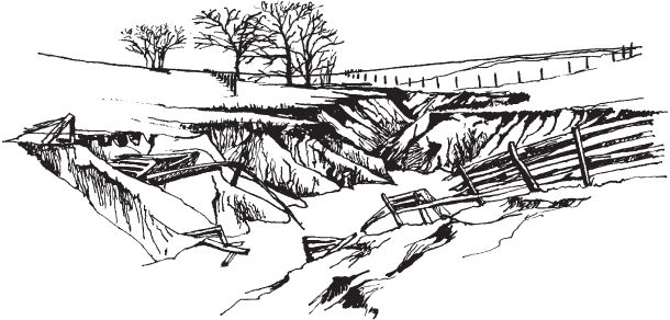
Figure 10.4 Gully erosion can be spectacular.
Figure 10.5 Rill and sheet erosion can result in great soil loss.
Stream bank erosion is another type of erosion caused by swift moving water that occurs when channels are widened during flood or near-flood conditions. The increased energy of the stream undercuts the stream bank to the point that large blocks of soil actually drop into the channel. The best way to prevent stream bank erosion is to maintain riparian zones with adequate vegetation such as trees and grasses. If stream banks are disturbed through construction, overgrazing, or channelization, stream bank erosion rates skyrocket.
Water Erosion Control
It is an old adage that “an ounce of prevention is worth a pound of cure.” This certainly applies to soil erosion control. Because soil particles do not move until they are detached, every effort should be made to prevent this from happening in the first place. Two factors should be kept in mind in this regard. The first is that the strong, water-stable aggregates usually associated with high organic matter content allow water to infiltrate harmlessly into the soil. Second, a cover of vegetation or plant residues functions to dissipate the energy of raindrops so they cannot strike directly on the soil aggregates (Fig. 10.6).
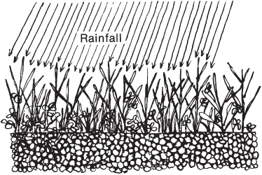
Figure 10.6 Two safeguards against soil erosion are vegetative cover and well-aggregated soil.
The fundamental principle of preventing the transportation of detached soil particles by runoff water is to reduce the rate of flow down the slopes. Slow-moving water does not have the energy to transport a large load, and the slower speed allows more time for the water to infiltrate.
Contouring and Strip Cropping
One of the common ways of controlling runoff is to subdivide the sloping fields into contour strips (Fig. 10.7). Each strip is approximately perpendicular to the downhill path the water would take. Alternate strips usually contain a row crop such as corn in one strip and a forage or small grain crop in the alternate row. The ridges in the strip crop reduce the water flow and minimize erosion there, and little erosion can occur in the dense plant cover in the alternate strips. No-till planting, in which the previous year's crop residue is left on the surface, is another practice that reduces erosion even when it is not done on the contour. It permits use of agricultural equipment that is too large for contour strip-cropping operations.
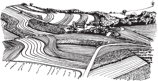
Figure 10.7 Contouring is very helpful in controlling runoff.
Grass Waterways
Where water concentrates in channels and flows in an uncontrolled manner, the channels may become gullies. Grass waterways (Fig. 10.8) can reduce the risk of gully formation because the dense fibrous root system of grasses holds the soil securely against the force of the flowing water. Grass waterways may be planted in natural channels that lead downslope, in diversion ditches on the sides of slopes, and at the foot of adjoining slopes.
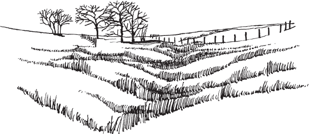
Figure 10.8 A grassed waterway offers erosion protection.
Conservation Structures
If the natural slope of the channel is too steep, it can be flattened out between steel or concrete structures called drop spillways (Fig. 10.9), which act as steps in the channel. At each step, the water drops over a headwall and falls on a concrete apron from which it flows onward through a grassed waterway.
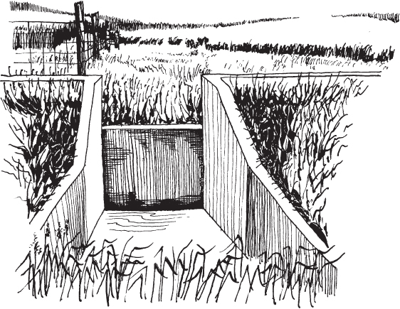
Figure 10.9 A drop spillway is an erosion control structure that prevents gully erosion.
In commercial agriculture today, conservation practices have advanced to the point that gullies are seldom a major problem. The size of farm machinery is such that if gullies start to form, they are easily removed. If gullies continue to form, however, farmers often are forced to divide their fields inconveniently because large gullies cannot be crossed with machinery. Fences are undercut, and roads have to be rerouted around advancing gullies. In some instances buildings have toppled into them.
To stop the advance of a gully, the soil must be stabilized at its head where the waterfall action is occurring. Sometimes the head of the gully is filled in with concrete or rubble (riprap), and the sides and bottom are planted with trees, grass, and shrubs. These practices may be combined with the use of a chute through which runoff water passes to prevent any further undercutting at the gully head. Various other techniques may be employed, depending on the specific problems at hand.
Contour Ridges and Terraces
A principal point to keep in mind is that in many cases it is desirable to keep as much of the water as possible where it falls or is applied by irrigation so that it can move into the soil and be used by plants. This is very important in arid and semiarid areas where moisture is often the limiting factor. Contouring and strip cropping are techniques in this category. Another approach is furrow diking, which is an old practice that is now being used much more commonly in dryland areas (Fig. 10.10). A dike is placed in each furrow at intervals of 6–12 ft (1.8–3.6 m), with a resulting depression holding water between the dikes. This greatly decreases runoff and improves plant growth. In the furrows the tractor follows during harvest; the dikes must be removed by sweeps mounted in front of the tractor.
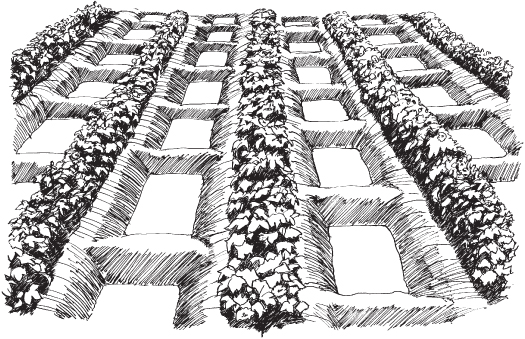
Figure 10.10 Furrow dikes trap most of the water that falls as rain or by sprinkler irrigation so it can be used by the crop.
Another mechanical erosion control practice is terracing. There may be no older erosion control method than the construction of terraces some of which are more than two thousand years old. In some parts of the world, entire mountainsides have been modified into a series of steps by bench terraces, each one supported by a retaining wall made of stones (Fig. 10.11). Tremendous amounts of labor were required to construct them, and they still require labor to maintain, which is very cheap in some areas. Terraces on a much more modest scale have been used compatibly with modern agriculture. In these cases, ridges are built several yards (meters) apart across the slope of the hills to trap water falling on the soil between the terraces. Presently, the trapped water is usually allowed to flow down the hill through buried tiles so that erosion does not occur (Fig. 10.12). In drier areas, the water may simply be held above the terrace until it soaks into the ground.

Figure 10.11 Agricultural terraces for rice production in the highlands of Vietnam. These terraces are irrigated and have been productive for more than 1,000 years.
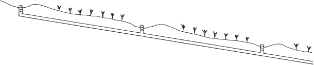
Figure 10.12 Parallel terraces may be drained by buried tiles.
Erosion by Wind
Whereas the loss of soil by water erosion is more widespread than by wind, it was the devastating wind erosion of the drought years of the mid-1930s in the United States that focused attention on all types of soil erosion and brought about legislation dedicated to soil conservation (Fig. 10.13). In the late part of the nineteenth century and in the early twentieth century, much of the prairie in the Midwest was plowed with huge steam tractors and planted to wheat. In addition, much of the unplowed land was overgrazed so that the soil was also left with an inadequate vegetative cover to afford protection. When the drought and winds came in the 1930s, soil from the Great Plains was blown aloft in ominous dark clouds that sometimes reached the Atlantic Coast and even out to sea. Fences were covered, road ditches were filled, and farmyards were smothered with eroded soil, and there was much despair in the hearts of farmers and city folks alike. Even today, wind erosion continues to move vast quantities of the most fertile topsoil, thereby reducing the productive capacity of cropland.
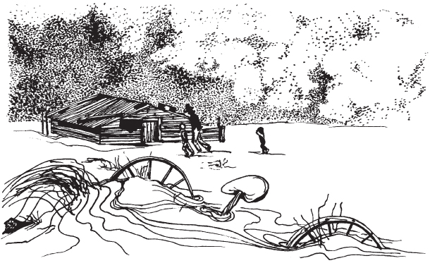
Figure 10.13 Although less common than water erosion, wind erosion can be devastating.
Types of Wind Erosion
Wind erosion occurs when the wind is sufficiently (a) strong to move soil particles along the soil surface; (b) turbulent to keep particles suspended; and (c) gusty to keep soil moving. There are three processes that occur during wind erosion events: saltation, surface creep, and suspension (Fig. 10.14).
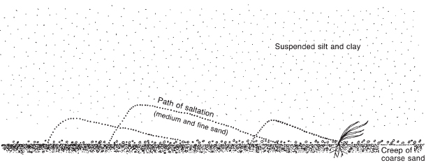
Figure 10.14 Wind erosion transports soil particles by creep, saltation, and suspension.
Saltation is the bouncing of medium and fine sand particles along the surface after they initially start to roll. The bouncing sand particles hit other soil particles which then project other particles (sand, silt, or clay particles or small soil aggregates) into the air. Surface creep is the rolling of coarse sand particles on the soil surface. Damage occurs to growing plants when surface creep and saltation occur. Sand particles constantly bombard the growing plants and eventually kill them if the wind is severe. Row crops less than about 4 in. (10 cm) tall can be cut off by the blowing soil. To protect the crop, farmers will often till strips on the ridges of the field to bring moist soil to the surface in the hope that the high winds will be temporary.
The abrasive action of the sand particles loosens finer soil particles, silt and clay, and brings about the third type of wind erosion, suspension. These fine soil particles, silt and clay, are often suspended in the air, resulting in a dust storm, and may be carried hundreds of miles. Although this may not be too damaging to growing crops, the loss of valuable topsoil with its organic matter and nutrients is costly. Damage may also occur when the soil particles are deposited. Deposition may be at the edge of a field where sand is deposited or many miles away from the origin of the particles. Recent studies have shown that dust from deserts in Africa blows across the south Atlantic and supplies nutrients for plant growth on otherwise infertile soil in the Amazon basin of South America.
Control of Wind Erosion
Vegetative Covers
Control of erosion by wind is achieved by slowing down the wind at ground level, much the same as controlling erosion by water is accomplished by slowing the runoff. Vegetative cover is the most effective means of control by simply keeping the soil covered so that it cannot be blown away. The vegetation may be alive in the form of a growing crop cover, or it may be dead plant residue sheltering the soil (Fig. 10.15). Often crop residue of this nature is partially incorporated but a portion is left on the surface to prevent blowing of the soil. The common tillage method to achieve this stubble mulching is shown in Figure 10.16.
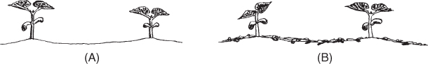
Figure 10.15 An unprotected soil surface (A) invites erosion, but crop residue on the surface (B) gives protection from wind and water erosion.
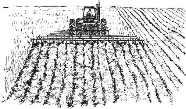
Figure 10.16 Stubble-mulching loosens the soil but leaves most of the plant residue on the surface.
Roughened Soil Surface
Leaving the soil in a roughened condition also helps control wind erosion. Any obstacle in the way of a moving soil particle deters it and, in many cases, stops it. The obstacle might be cloddy soil, pitted areas in the soil surface, or ridged rows that have been prepared. Farmers in the Great Plains of the United States use a sand fighter, which is an implement taken over a field after a rain when the soil surface is smooth to create thousands of small pits and mounds to impede the movement of soil. This is usually done in the spring when wind speeds are highest and crops have just been or are soon to be planted. Using a sand fighter may kill a few plants if the crop is up, but damage is minimal.
Strip Cropping
Strip cropping is another means of minimizing soil movement by wind. The pattern would be similar to that used for erosion control by water, such as preparing a seedbed in the standard method for 8–12 rows but leaving 1–2 rows of the old crop standing. Strip cropping is often used on vegetables grown following a volunteer wheat crop.
Windbreaks
Windbreaks, or shelterbelts (Fig. 10.17), are used in many areas where erosion by wind is a problem. A planting of trees, shrubs, or grass strips helps to slow the wind and decrease soil movement. To be effective, the distance between windbreaks should not be too great. The distance for best control varies from one area to another. Windbreaks are used less today due to the advent of larger machinery for tillage and harvest operations. Farming around windbreaks takes more time and the trees in the windbreak consume soil moisture needed by the crops. Contact your local Natural Resources Conservation Service personnel for specifics.
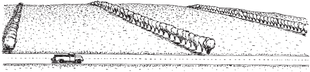
Figure 10.17 Shelterbelts and rough soil surfaces can reduce wind erosion.
Soil Stabilizers
Soil stabilizers might also reduce erosion by wind or water. These include organic matter that acts as a binding agent, chemicals that cause soil particles to aggregate, and water. Water stabilizes the soil for the time when it is moist, but when the surface dries out, it is again susceptible to wind erosion.
Erosion by Mass Wasting
Mass wasting is another type of erosion that takes place in several ways. Masses of soil sometimes move under the force of gravity, as by cave-ins along riverbanks (Fig. 10.18) and slump along gully sides and road banks. Soil creep is a common type of mass wasting in regions where the soil freezes and thaws repeatedly each autumn and early spring (Fig. 10.19). Frost causes the surface soil to expand perpendicular to the slope; when the soil thaws, it drops vertically. This causes a ripple effect on the hillsides. Cattle often make paths that accentuate these ripples. Mass wasting not only may remove portions of cultivated fields and pastures but also sections of roads and even homes (as in the mudslides in California).
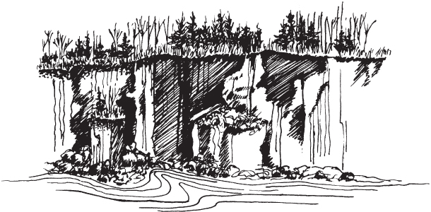
Figure 10.18 Erosion loss can be great from cave-ins along riverbanks.
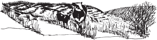
Figure 10.19 Cattle paths accentuate ripples made by mass wasting.
Diversion of water away from susceptible areas is helpful. Protection of riverbanks with riprap, timberwork, and vegetation reduces the incidence of mass wasting. In some cases, channelization is needed but, in general, is only a temporary solution. Similar protection is also being sought for shorelines and beaches; huge sand-filled plastic tubes are laid at the foot of an endangered bluff at a lake or seashore to block the force of waves. The city of Miami, Florida, has spent huge sums of money trying to decrease beach erosion along much of its waterfront.
Whenever soil is moved by wind, water, or gravity, it is likely to cause immediate problems in addition to those of a more long-range nature. The occurrence of massive mudslides in such places as California usually attracts widespread media attention. This accelerated erosion is often attributable to the loss of vegetation due to fire or logging. Houses may be filled with the flowing ooze or even swept down the hillsides.
Sediment as a Pollutant
Eroded soil from uplands is carried by rushing water until the water slows down and drops its load of sediment in river channels, harbors, and reservoirs (Fig. 10.20). Dredging these sediments to remove the sediment is costly. Depleted channels increase the threat of flooding, which causes untold hardships to homeowners and businesses. Dams built to control floodwaters and provide other services such as recreation and electric power lose their value as the capacity of their reservoirs decreases. In extreme cases, expensive new dams have become a burden to the taxpayer in as little as 25 years.
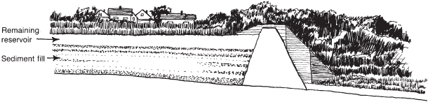
Figure 10.20 Erosion not only reduces the value of cropland but also causes serious sedimentation problems.
Sand can be a sediment since it fills ditches, covers roads and fences, and causes similar problems. When it is blown along by the wind, it is a serious problem, whether in central Wisconsin or in New Mexico. Valuable topsoil is lost and productivity declines, and small plants are cut off or abraded so that they fall prey to disease. The abrasive action of sand can remove paint from buildings and automobiles, and result in textural changes in soil surface horizons. This loss of soil is also a loss of valuable plant nutrients and can carry pesticides into receiving streams and lakes.
It should be apparent that soil conservation pays. It pays where the soil is retained because the land can be more productive, and it also cuts costs downstream where the capacity of reservoirs is protected and water quality for domestic, irrigation, and recreational uses is preserved.
One of the few benefits of sedimentation is that it results in the formation of alluvial soils in flood plains and at the mouth of rivers such as the delta of the Mississippi River.
Extent of the Problem
A natural resource inventory reported by the Natural Resources Conservation Service (NRCS), in 1992, revealed that the national average soil loss per year on all cropland due to water erosion was 3.1 tons per acre (T/A) equal to 6.9 megagram per hectare (Mg/ha) per year. The figure varies for different parts of the country, ranging from 6.2 tons per acre (13.9 Mg/ha) per year in Alabama to 0.1 (0.2 Mg/ha) in Colorado.
Many highly eroded areas experience losses in excess of 20 tons per acre (45 Mg/ha) per year. Drier regions with low amounts of water erosion may experience losses from wind erosion that match or exceed these values. Nationwide, wind erosion losses average 2.5 tons per acre (5.6 Mg/ha) per year. Comparative values for years prior to 1992 were 3.2 T/A (7.2 Mg/ha) in 1987 and 3.3 T/A (7.4 Mg/ha) in 1982. NRCS reported the 1992 wind erosion figures for the individual states. The highest wind erosion occurred in New Mexico, which lost 13.5 T/A (30.2 Mg/ha) per year, while several states in the higher rainfall areas showed no wind erosion losses. Some of these states are Alabama, Arkansas, Connecticut, Georgia, Hawaii, and Kentucky.
To place these figures in perspective, it is worthwhile noting that 1 in. (2.54 cm) of soil weighs about 150 tons (136 Mg). By using some of the soil-loss figures cited above, it is easy to calculate how long it takes to lose an inch of topsoil at those rates. For example, at 5 tons per acre (11.2 Mg/ha) per year, 1 in. (2.54 cm) of soil is lost every 30 years.
It is important to remember that eroded soil is not necessarily removed from a farm and transported to a lake or to the sea. It is more likely to be shifted from the high ground to the low ground. The high ground becomes much less productive, and crops on the low ground may be damaged by sediment and eventually those soils may become more productive.
Despite the great work of researchers and government agencies, the NRCS in particular, only about one-half of the farmers in the United States have requested conservation plans for their land, and only about one half of those have carried them out. Some of the best-managed farms may have changed ownership and resulted in the soil conservation practices being abandoned by the new owners.
An excellent US Department of Agriculture (USDA) publication by W. C. Lowdermilk in 1953, “Conquest of the Land through 7,000 Years,” cites many examples of Old World states whose foundations were based upon agriculture and whose demise came when their abused land was no longer productive. In some cases, population increases placed too high a demand on the fragile soil, and in others, political instability led to neglect of both the soil and the irrigation systems.
It may appear to some farmers today that soil conservation really is not very important. For instance, a yield of 200 bushels of corn per acre (12.5 Mg/ha) can be achieved on the black prairie soils of Illinois under an annual rainfall of 40 in. (1,000 mm). Wherever soil deteriorates by erosion (and that is just about everywhere in cultivated fields) and by compaction, which reduces soil aeration, farmers can still obtain high yields by adding more fertilizer, by planting more vigorous hybrid corn varieties, and even by irrigating in seasons of low rainfall. Thus good crop yields are achieved decade after decade, while the soil is slowly but surely wasting away unnoticed. News reports of crop surpluses in the United States and many other countries lull the public and politicians into complacency on the state of the soil resource.
Our U.S. population continues to grow. With this growth there have been astronomical rates of urbanization that destroys many acres of prime farmland each day. Hopefully, it will become a national priority to keep our prime farmland growing needed food crops and not growing houses and septic tanks. If current population growth continues, this land will be needed to feed future generations.