 The bald eagle was adopted as the national bird of the United States of America in 1782 and to this day stands as a symbol of freedom. These regal eagles have a wingspan of up to 8 feet. Now that’s impressive.
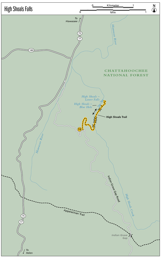
15 High Shoals Falls
Twice the treat! The High Shoals Trail offers two incredible waterfalls. The first treat is the Blue Hole. In a word . . . Inviting! The waters of the Blue Hole open their arms to you and inspire you to spend an afternoon picnicking and basking in their delight. The Lower Falls at High Shoals is yet to come. Like the talons of an eagle catching its prey, the water here clings to the rock as it swoops down the mountainside.
Height: Blue Hole, 25 feet; Lower Falls, 100 feet
Distance: 2.4 miles out and back
Trail surface: Hard-packed dirt
Approximate hiking time: 1 hour, 30 minutes
Blaze color: Green
County: Towns
Land status: National park
Trail contact: Chattahoochee National Forest, Blue Ridge Ranger District; (706) 745-6928; www.fs.fed.us
Maps: DeLorme: Georgia Atlas & Gazetteer: Page 15 C9
Finding the trailhead: From the junction of GA 75 and GA 356, drive north on GA 75 for 10.4 miles. Turn right onto Indian Grave Gap Road (FS 283) at the sign for High Shoals and travel 1.3 miles to the small parking area on the left next to some trash cans.
From the junction of GA 75 and GA 180, drive south on GA 75 for 0.5 mile. Turn left onto Indian Grave Gap Road (FS 283) at the sign for High Shoals and follow the directions above.
The trailhead for High Shoals Trail (#19) is located at the north end of the parking area. (Note: Indian Grave Gap Road fords a small creek. On days when water levels are high, you may need a high-clearance vehicle to ford the creek.) GPS: N34 48.968 / W83 43.626
The Hike
From the trailhead, take the steps down into the woods and onto the well-maintained, easily followed trail. The trail continues to descend until you reach a post sticking out of the ground with a missing sign. At this post, you will see a narrow trail heading straight ahead and the wider main trail that turns to the right. Go right here, following the main trail as it continues its descent toward the forest floor.
When you finally reach the forest floor, go left (north), following the wide High Shoals Trail. Enjoy a flat forest stroll alongside the creek until you come to a wooden footbridge. Cross it, and head left. Three more footbridges/log planks follow. After crossing the last of them, head downhill and you will see, and hear, the falls on your left. A side trail makes a sharp left switchback to an observation deck at the base of Blue Hole Falls.
The bald eagle was adopted as the national bird of the United States of America in 1782 and to this day stands as a symbol of freedom. These regal eagles have a wingspan of up to 8 feet. Now that’s impressive.
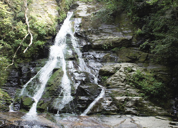
High Shoals Falls clings to the rocky mountainside.
After enjoying the Blue Hole, head back up to the main trail and continue to the Lower Falls. The trail continues its descent into the forest and around some switchbacks until you arrive at the observation deck at the base of the High Shoals Lower Falls.
The High Shoals Scenic Area that is home to these wonderful waterfalls covers 170 acres. There are actually five falls in succession along the creek, but in an effort to protect the area, I have chosen to include only those with maintained trails.
Indian Grave Gap Road, your access road, was named for Indian Grave Gap, which sits at 3,120 feet. Given the history of this area, there’s a good chance it was aptly named.
Miles and Directions
0.0From the trailhead, take the steps north, down into the woods.
0.2Come to a junction marked by a post sticking out of the ground. A narrow trail heads straight ahead; the wider main trail turns to the right. Go right (south) here and continue following the High Shoals Trail downhill.
0.6Enjoy the stroll along the forest floor before coming to a footbridge. Cross the bridge and continue north as you pass a primitive campsite.
0.7Cross a second and third footbridge as you continue to hike north.
0.9After crossing a fourth footbridge, hike northeast down the hill until you see and hear the falls on your left.
1.0A side trail makes a hard switchback to the left (west) and takes you down to an observation deck at the base of Blue Hole Falls (N34 49.292 / W83 43.331). From Blue Hole, head back up to the main trail and continue hiking northwest deeper into the forest. The trail descends as it leads around some switchbacks.
1.2Arrive at the base of High Shoals Lower Falls (N34 49.353 / W83 43.309). Return the way you came.
2.4Arrive back at the trailhead.