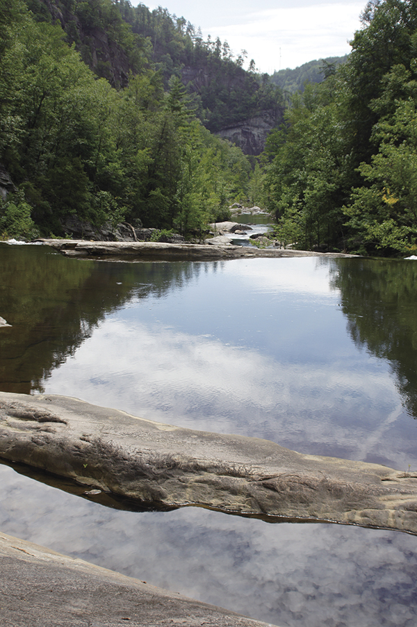
Savor the calm before the storm on the Tallulah River.
19 Bull Cove Falls
Solitary! Almost aloof, Bull Cove Falls stands out in its stately manner above and very different from the rest of the many playful smaller cascades on the creek. Although Bull Cove Falls is located in North Carolina, you must drive into and through Tate City, Georgia, to access the trailhead. While in the area, you can also visit nearby Denton Branch Falls.
Height: 40 feet
Distance: 2.2 miles out and back
Trail surface: Hard-packed dirt
Approximate hiking time: 1 hour, 30 minutes
Blaze color: Blue
County: Clay
Land status: National forest
Trail contact: Nantahala National Forest, Tusquitee Ranger District; (828) 837-5152; www.fs.fed.us
Maps: DeLorme: Georgia Atlas & Gazetteer: Page 16 A1; DeLorme: North Carolina Atlas & Gazetteer: Page 51 F6
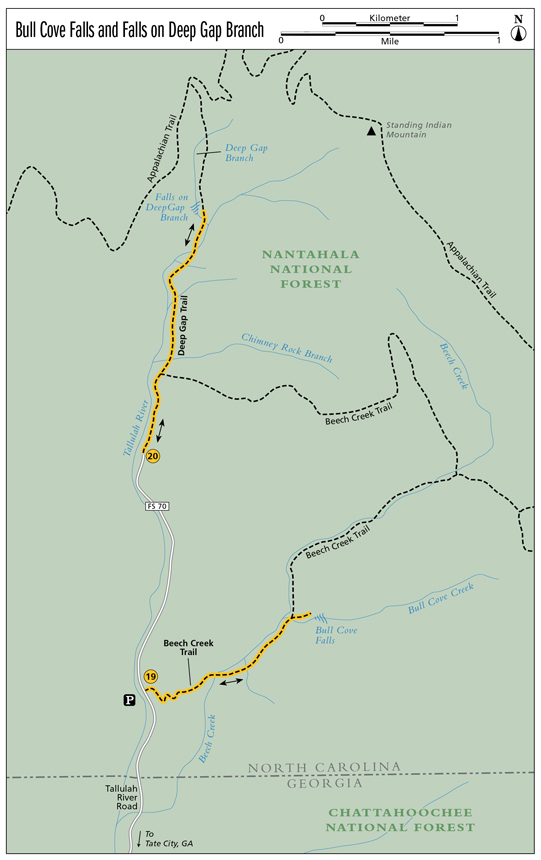
Finding the trailhead: From the junction of US 76 west and US 441, drive west on US 76 for 7.9 miles. Turn right onto Persimmon Road at the sign for Tallulah River Campground and travel 4.0 miles to a left turn onto Tallulah River Road (FS 70). Continue for 1.4 miles to the Tallulah River Campground. Bypass the campground and continue straight ahead on the now unpaved Tallulah River Road for another 5.95 miles (entering North Carolina) to a parking area on the left with a sign for the Beech Creek Trailhead.
From the junction of US 76 and GA 197, drive east on US 76 for 3.0 miles. Turn left onto Persimmon Road at the sign for Tallulah River Campground and follow the directions above.
The trailhead for Bull Cove Falls is located on the opposite (east) side of the road from where you parked and approximately 50 feet to the south. GPS: N34 59.895 / W83 33.385
The Hike
The trailhead is marked with blue blazes on the trees and a sign for Trail #378, which is the Beech Creek Trail. The dirt path heads steeply uphill and into the woods. Once in the forest, the trail traverses several switchbacks as it slowly climbs. When you finally reach the top of the hill, the trail flattens out to give you a breather before beginning a steep descent to Beech Creek.
Ford the creek and then head left, following the trail upstream to a T junction. Go left here and you soon come to rock-hop across a tributary. As the trail continues to lead upstream, you can hear the sounds of many splendid small cascades. Bypass these and continue until you reach the creek again.
Cross the creek and head right (upstream) on the very narrow, overgrown path. You will pass several smaller falls, but don’t be fooled. Continue your near bushwhack as you make your way upstream to the much larger and more powerful Bull Cove Falls, identified by the logs that lie amidst both the lower and upper sections of the falls.
Please beware! While hiking the final portion of this trail alongside the creek, my dog, Mikey, and I were viciously attacked by yellow jackets from an underground nest. I highly recommend carrying Benadryl with you or, if you have known allergies, an EpiPen, just in case.
You can’t help but notice Tate City as you pass through it on your way to the trailhead. What really stands out is the barn with See Tate City painted on it in bold letters and the official road sign that reads Tate City—population 32 +/-. This sleepy little town is said to be one of the oldest settled areas in these mountains. It was once a thriving community known for its corundum mines. When the mines dried up, the town became a lumber camp. After the lumber boom ended, Tate City eventually evolved into what you see today.
Savor the calm before the storm on the Tallulah River.
 The southern yellow jacket is commonly mistaken for a bee when in fact it’s a wasp. These sinister stingers often live in underground nests, and a single colony can contain as many as 100,000 yellow jackets.
Miles and Directions
0.0From the trailhead, follow the dirt path east as it heads steeply uphill and into the woods. Almost immediately come to a fork; go left (north) at the fork.
0.1Come to a T junction. Go left (east) at the T; the trail continues to climb before leading to another fork. Go right (south-southeast) here. The trail slowly traverses a few switchbacks as you make your way uphill.
0.3Reach the top of the hill; the trail bends left (northeast).
0.6The trail leads down to Beech Creek. Ford the creek and then head left (east), following the creek upstream.
0.7Come to a T junction and go left (east-northeast). After hiking a short distance, reach a tributary. Rock-hop across and continue hiking north-northeast.
1.0The rocky path crosses the creek one last time. After crossing, head right (east) and follow the creek upstream on the very narrow path.
1.1Arrive at the base of Bull Cove Falls (N35 00.184 / W83 32.561). Return the way you came.
2.2Arrive back at the trailhead.