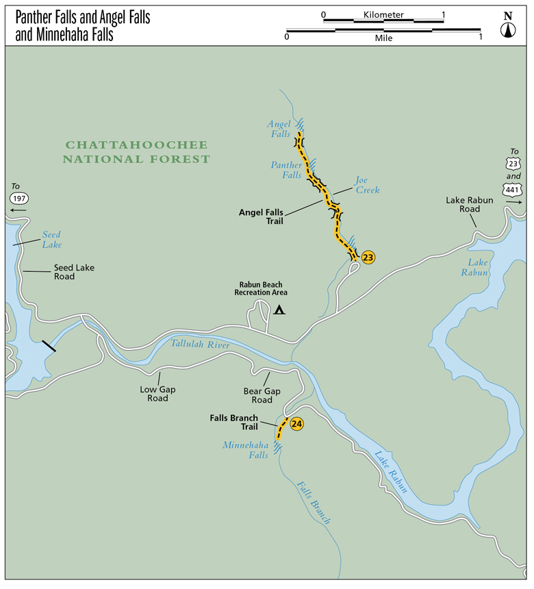
23 Panther and Angel Falls
Sumptuous! The trail to Panther and Angel Falls (also known as the Rabun Beach Trail) gives the hiker two waterfalls for the price of one. Fairly similar in appearance, they both resemble a staircase carved out by Mother Nature. You can’t help but wonder how long it took to create such a phenomenon.
Height: Panther Falls, 50 feet; Angel Falls, 65 feet
Distance: Panther Falls, 1.2 miles; Angel Falls, 1.6 miles out and back
Trail surface: Hard-packed dirt
Approximate hiking time: Panther Falls, 40 minutes; Angel Falls, 1 hour, 10 minutes
Blaze color: Green
County: Rabun
Land status: National forest
Trail contact: Chattahoochee National Forest, Chattooga Ranger District; (706) 754-6221; www.fs.fed.us
FYI: Small fee to park and hike here
Maps: DeLorme: Georgia Atlas & Gazetteer: Page 16 D2
Finding the trailhead: From the junction of US 441 and US 76 east, drive south on US 441 for 8.9 miles. Turn right onto Old 441 south and follow it for 2.5 miles to a left turn onto Lake Rabun Road. Continue for 4.6 miles and turn right into Rabun Beach Recreation Area #2. Once inside the recreation area, immediately turn right (bypass this fee station; there is another one at the trailhead) and travel a little more than 0.1 mile to a parking area on the right, next to the phone booth.
From the junction of US 441 and the north end of the Riley C. Thurmond Bridge, drive north on US 441 for 1.7 miles. Turn left onto Old 441 south and follow the directions above.
From the junction of GA 197 and GA 356, drive north on GA 197 for 3.0 miles. Turn right onto Burton Dam Road at the Chevron Gas Station/Brooks Lil General Store and travel 8.8 miles to a left turn into the Rabun Beach Recreation Area #2 at the tiny sign for Camping Area #2. Along the way, Burton Dam Road becomes Seed Lake Road and then Lake Rabun Road. After turning into the recreation area, follow the directions above.
From the junction of GA 197 and US 76, drive south on GA 197 for 8.2 miles. Turn left onto Burton Dam Road at the Chevron Gas Station/Brooks Lil General Store and travel 8.8 miles to a left turn into the Rabun Beach Recreation Area #2 at the tiny sign for Camping Area #2. Along the way Burton Dam Road becomes Seed Lake Road and then Lake Rabun Road. After turning into the recreation area, follow the directions above.
The clearly marked trailhead for the Angel Falls Trail (#55) is located northwest of the parking area. GPS: N34 45.674 / W83 28.375
The Hike
Follow the trail into the woods and immediately cross Joe Creek at the base of a wonderful stairwaylike waterfall. The trail then begins its incline as it follows the creek upstream. This easy-to-follow path takes you across four more footbridges before making its final, steeper ascent to the base of Panther Falls.
From the base of Panther Falls, a steep and narrow trail leads up and to the left (southwest) toward Angel Falls. Follow this trail as it climbs around a switchback and then takes you past the brink of Panther Falls. From here the trail takes you across a final wooden footbridge before reaching a fork just a short distance from Angel Falls. From the fork, you can go either way; both paths take you to the taller, narrower Angel Falls, creating a tiny loop in the trail.
With 25 miles of shoreline, beautiful Lake Rabun has been a popular recreation area since the 1930s, when the first homesites were built. A variety of activities can be enjoyed here in addition to hiking, including fishing, boating, swimming, picnicking, and camping.
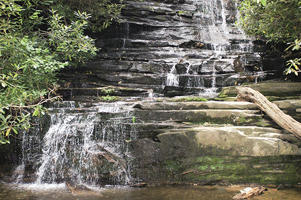
Mother Nature’s stair “steps” create Panther Falls.
Miles and Directions
0.0From the trailhead, hike north into the woods. Immediately cross the creek at the base of a wonderful stairwaylike waterfall. From here the trail begins its incline as it follows Joe Creek upstream.
0.3Cross a footbridge and continue hiking north.
0.4Cross another footbridge; continue hiking northwest.
0.5Cross a third and fourth footbridge and continue hiking northwest as the trail begins its steeper ascent.
0.6Arrive at the base of Panther Falls (N34 46.070 / W83 28.633). From the base of Panther Falls, a narrow trail heads steeply uphill to the left (southwest). Follow this trail as it climbs around a switchback and leads to the brink of Panther Falls.
0.7The easily followed trail takes you across one final footbridge. Continue hiking north-northeast.
0.8Come to a fork in the trail. Go either way here; these two trails make a tiny loop, and both lead to Angel Falls (N34 46.268 / W83 28.695). Return the way you came.
1.6Arrive back at the trailhead.