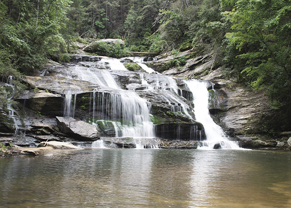
Everything about Panther Creek Falls is breathtaking.
25 Panther Creek Falls
Grandeur! Like a Phoenix in flight, this waterfall inspires and amazes all who visit. Easily making the author’s favorites list, Panther Creek Falls is one of the most beautiful waterfalls in the area. A wonderful place for a picnic or a quick dip, it gets quite a few hikers, especially on the weekends. You are not likely to have this one to yourself for long, if at all.
Height: 75 feet
Distance: 7.0 miles out and back
Trail surface: Hard-packed dirt
Approximate hiking time: 3 hours, 15 minutes
Blaze color: Green
County: Habersham
Land status: National forest
Trail contact: Chattahoochee National Forest, Chattooga Ranger District; (706) 754-6221; www.fs.fed.us
FYI: Open 7 a.m. to 10 p.m.; small day-use fee
Maps: DeLorme: Georgia Atlas & Gazetteer: Page 16 E2
Finding the trailhead: From the junction of US 441 and US 76 east, drive south on US 441 for 13.1 miles. Turn right onto Old Historic 441 (look for the sign for Panther Creek Picnic Area and Trail) and travel 1.5 miles to a right turn into the parking area for the Chattahoochee National Forest Panther Creek Area.
From the junction of US 441 and GA 17 Alternate, drive north on US 441 for 3.0 miles. Turn left onto Glenn Hardman Road just south of mile marker 18 and travel 0.1 mile to where the road dead-ends at a stop sign (a U.S. post office will be right in front of you). Go right here, continuing 1.0 mile to a left turn into the parking area for the Chattahoochee National Forest Panther Creek Area.
From the junction of GA 197 and US 76, drive south on GA 197 for 7.1 miles. Turn left onto Raper Mountain Road just before the Batesville Junction Gas Station and travel 1.8 miles to a stop sign at Oakey Mountain Road. Go left onto Oakey Mountain Road (which becomes New Liberty Road) and follow it for 7.3 miles. Turn left onto Orchard Road and continue for 5.1 miles to where it dead-ends at Old Historic Highway 441. Go left here and travel 0.6 mile before turning left into the parking area for Panther Creek Falls, just before the Chattahoochee National Forest sign for Panther Creek Area.
From the junction of GA 197 and GA 356, drive north on GA 197 for 0.8 mile. Turn right onto Raper Mountain Road just past the Batesville Junction Gas Station and follow the directions above.
The trailhead to Panther Creek Falls is located just across the street (southeast) from the parking area. GPS: N34 41.931 / W83 25.170
The Hike
The narrow trail takes you under US 441 and into an open grassy field. After crossing the field, it heads back into the woods and downhill. The trail bends left at the creek and then takes you through one more open area as you pass under some power lines. Don’t be discouraged, the trail heads back into the forest, where it stays for the remainder of the hike.
Continue following the green blazes on the easy-to-follow trail until you reach some large boulders hanging over the trail. Continue under and around them; the well-maintained path returns once you reach the other side. Follow the trail as it twists and turns high above the creek’s edge.
When you finally reach the creek at a primitive campsite, you will come to a wooden footbridge. Cross it and continue hiking downstream to another wooden footbridge. Cross this as well as you continue hiking deeper into the forest. Cross a third wooden footbridge and continue following the main trail in a generally southerly direction.
Everything about Panther Creek Falls is breathtaking.
The trail now rises high above the bank of Panther Creek. After rock-hopping a small stream, the trail makes an uphill climb. You will cross a fourth footbridge, and again the trail climbs to the cliffs overhanging the creek. Guy wires act as a makeshift “guardrail” to prevent you from falling, but I don’t think I’d put my full body weight on them.
The trail flattens out a bit, and you rock-hop another tributary. Again you come to a rise above the creek with guy wires. After descending this rise, stay on the main trail and continue following the creek downstream. You soon come to your third rise with guy wires. Upon coming down from this one, you find yourself out on some boulders just above the brink of Panther Creek Falls. Enjoy the view from here before continuing to follow the steep path a short distance downstream over your final guy wire rise and down to the base of Panther Creek Falls.
With a sandy beach at the base and perfect panoramic views, Panther Creek Falls is a very welcome sight.
The USDA Forest Service has designated nearly 600 acres in two separate tracts along the river as the Panther Creek Botanical Area. Both tracts are located downstream from the falls and are protected due to the richness and diversity of the plant life they contain—flora that is typically uncommon in northern Georgia. The river here lies directly on the Brevard Fault, giving the soil below an excessive amount of limestone content. It is this high concentration of limestone that allows the area to support such rare vegetation.
 Botany is one of the oldest branches of biology. Simply put, it’s the study of plant life.
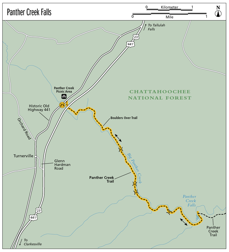
Miles and Directions
0.0From the parking area, walk south back up to Old 441, cross the road, and head left (east) a very short distance to the trailhead. The narrow trail leads south and takes you under US 441 before taking you across an open grassy field.
0.5The trail brings you through another open area, and you pass under some power lines. Continue hiking southeast and the trail leads back into the forest, where it remains for the rest of the hike.
0.8Come to some large boulders hanging over the trail. Go south-southeast as you make your way under and around the boulders.
1.4Reach the creek at a primitive campsite followed by a wooden footbridge. Cross the footbridge and continue hiking downstream (west-southwest).
1.9Cross a second footbridge and continue hiking south as you make your way deeper into the forest.
2.0Cross a third footbridge and continue to follow the Panther Creek Trail generally south. The trail now rises high above the bank of the creek.
2.3Rock-hop a small stream. The trail makes an uphill climb as it leads southeast.
2.6Cross a fourth footbridge. The trail again climbs to the cliffs overhanging the creek as you continue to hike southeast.
3.0The trail flattens out a bit, and you rock-hop across another tributary. Continue east and again come to a rise above the creek, with guy wires acting as a makeshift guardrail.
3.3Come to a third rise with guy wires. Coming down from this one, find yourself out on some boulders just above the brink of the falls. Enjoy the view from here before continuing northeast, following the trail steeply downhill.
3.5Arrive at the sandy beach at the base of Panther Creek Falls (N34 40.638 / W83 23.288). Return the way you came.
7.0Arrive back at the trailhead.

The lovely bearded iris is common in the Georgia mountains.