 Each rapid in a river is classified on a standardized scale according to difficulty. The International Scale of River Difficulty ranges from the tamest Class I rapid to the most difficult, often “unrunnable,” Class VI.
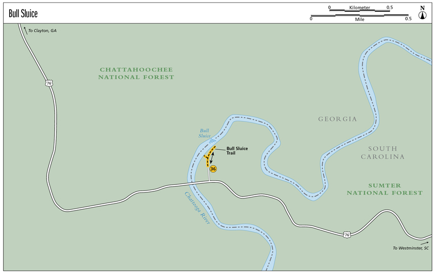
36 Bull Sluice
Serene! This Class V rapid along Section III of the Wild and Scenic Chattooga River falls and flows perfectly over the rocky-bottomed river floor. With strength and serenity, it holds your gaze.
Height: 10 feet
Distance: 0.4 mile out and back
Trail surface: Paved path and gravel trail
Approximate hiking time: 20 minutes
Blaze color: No blazes
County: Rabun, Georgia; Oconee, South Carolina
Land status: National forest
Trail contacts: Chattahoochee National Forest, Chattooga Ranger District; (706) 754-6221; www.fs.fed.us
Sumter National Forest, Andrew Pickens Ranger District; (864) 638-9568; www.fs.fed.us
Maps: DeLorme: South Carolina Atlas & Gazetteer: Page 16 B1; DeLorme: Georgia Atlas & Gazetteer: Page 16 D4
Finding the trailhead: From the junction of US 76 east and US 441, drive east on US 76 for 8.2 miles. Just after crossing the Chattooga River Bridge, pull into a parking area on the left signed for the Highway 76 Chattooga River Access Area.
From the junction of US 76 and US 123, drive west on US 76 for 17.7 miles. Just before crossing the Chattooga River Bridge, pull into a parking area on the right signed for the Highway 76 Chattooga River Access Area.
The trailhead is located next to the large pavilion at the north end of the parking lot. GPS: N34 48.905 / W83 18.306
The Hike
From the trailhead, follow the wide, paved path as it leads downhill and toward the river. Approximately 0.1 mile down the hill, a gravel trail shoots off to the right. Take this trail and follow it for another 0.1 mile as it leads to the Chattooga River at the base of the powerful rapid known as Bull Sluice.
For a quick side trip, backtrack to the paved path and continue to follow it downhill to where it comes out at a lovely sandy beach alongside the river. This beach is the launch site for river rafters as they head out to paddle Section IV of the Chattooga River.
Bull Sluice is located within a 15.7-mile stretch of the Chattooga that has been protected since the spring of 1974. The river proudly has national forest on both sides, giving it a wonderful buffer zone on which no commercial roads or development is allowed. It is said that the rocks that make up the riverbed were carved out over a span of 600 to 750 million years.
Each rapid in a river is classified on a standardized scale according to difficulty. The International Scale of River Difficulty ranges from the tamest Class I rapid to the most difficult, often “unrunnable,” Class VI.
Miles and Directions
0.0From the trailhead, hike north down the paved path as it heads downhill and toward the river.
0.1Reach a junction with a gravel trail off to the right (northeast). Follow this trail as it leads back into the woods from above the river.
0.2Arrive at the river’s edge at the base of Bull Sluice (N34 49.027 / W83 18.276). Return the way you came.
0.4Arrive back at the trailhead.
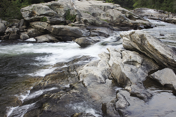
You might be lucky enough to see river rafters and kayakers run the Class V rapid known as Bull Sluice.