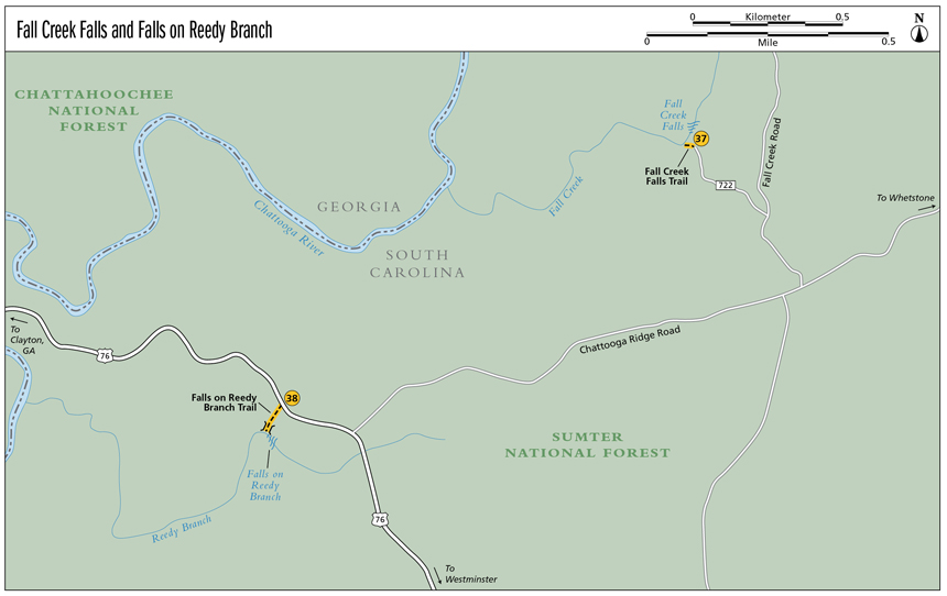
37 Fall Creek Falls
Inspiring! Like the wings of a dove flapping in the wind, Fall Creek Falls brings a similar offering of peace.
Height: 60 feet
Distance: 0.2 mile out and back
Trail surface: Hard-packed dirt
Approximate hiking time: 20 minutes
Blaze color: No blazes
County: Oconee
Land status: National forest
Trail contact: Sumter National Forest, Andrew Pickens Ranger District; (864) 638-9568; www.fs.fed.us
Maps: DeLorme: South Carolina Atlas & Gazetteer: Page 16 H1; DeLorme: Georgia Atlas & Gazetteer: Page 16 C4
Finding the trailhead: From the junction of US 76 and US 441 in Clayton, Georgia, drive east on US 76 for 10.0 miles. Turn left onto Chattooga Ridge Road and travel 2.0 miles to a left turn onto Fall Creek Road. Continue for 0.3 mile and turn left onto Fall Creek Road Extension (FS 722). Travel 0.5 mile to a small pull-off on the left, just after crossing a tiny stream that you can hear but not see.
From the junction of US 76 and the Chattooga River Bridge (Georgia–South Carolina state line), drive east on US 76 for 2.0 miles. Turn left onto Chattooga Ridge Road and follow the directions above.
From the junction of US 76 and US 123, drive west on US 76 for 15.2 miles. Turn right onto Chattooga Ridge Road and follow the directions above.
GPS: N34 49.363 / W83 15.049
The Hike
From the pull off you will see a narrow path that leads steeply downhill to the creek. Follow the path downstream for a very short distance to reach the brink of the falls. Continue steeply down into the woods just a little bit farther until you reach the creek at the base of Fall Creek Falls. For the best view, rock-hop out into the creek.
Aptly named, Fall Creek is home to not just one, but three cascades over a 1.0-mile stretch of creek. Each, however, is more difficult and challenging to reach than the one before. For this reason, I have only showcased the first.
Miles and Directions
0.0From the trailhead, hike south-southwest on the narrow path as it leads steeply downhill to the creek. Follow the creek downstream for a very short distance to reach the brink of the falls.
0.1Continue more steeply down into the woods until you reach the creek at the base of Fall Creek Falls (N34 49.368 / W83 15.084). Return the way you came.
0.2Arrive back at the trailhead.
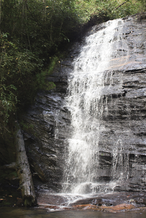
Standing up straight and tall, Fall Creek Falls outshines them all.