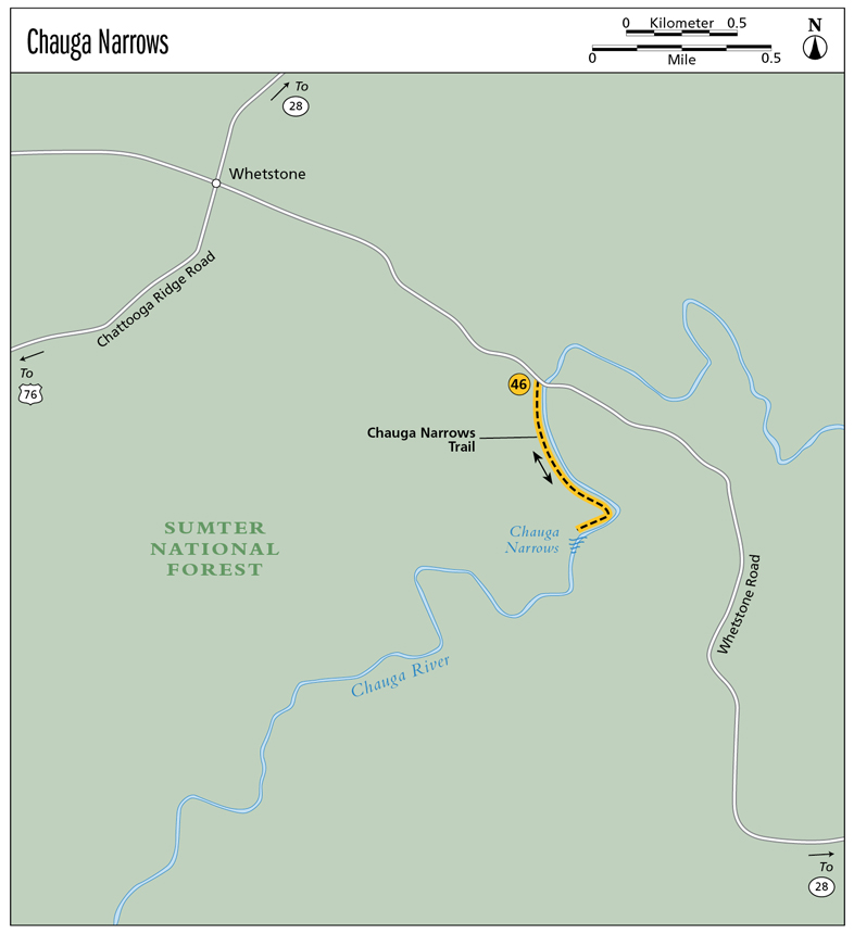
46 Chauga Narrows
Tremendous! Chauga Narrows flows like freedom itself, carving its way through the bonds of the boulders and then dropping to the calm of the river below. This one makes you feel as though you’ve entered another world, where nature rules and man is subservient to its will.
Height: 25 feet
Distance: 1.2 miles out and back
Trail surface: Hard-packed dirt
Approximate hiking time: 50 minutes
Blaze color: No blazes
County: Oconee
Land status: National forest
Trail contact: Sumter National Forest, Andrew Pickens Ranger District; (864) 638-9568; www.fs.fed.us
Maps: DeLorme: South Carolina Atlas & Gazetteer: Page 16 H2; DeLorme: Georgia Atlas & Gazetteer: Page 16 C5
Finding the trailhead: From the junction of US 76 and US 441 in Clayton, Georgia, drive east on US 76 for 10.0 miles. Turn left onto Chattooga Ridge Road and travel 5.7 miles to a four-way stop sign at Whetstone Road. Go right here, following Whetstone Road for 1.0 mile to a pull-off on the left just before the road crosses the Chauga River Bridge.
From the junction of US 76 and the Chattooga River Bridge (Georgia–South Carolina state line), drive east on US 76 for 2.0 miles. Turn left onto Chattooga Ridge Road and follow the directions above.
From the junction of US 76 and SC 123, drive west on US 76 for 15.2 miles. Turn right onto Chattooga Ridge Road and follow the directions above.
From the junction of SC 28 and SC 107, drive south on SC 28 for 1.9 miles. Turn right onto Whetstone Road and travel 5.0 miles to a pull-off on the right just after the road crosses the Chauga River Bridge.
The trailhead is located on the opposite (south) side of the road from the pull-off. GPS: N34 50.021 / W83 10.533
The Hike
Cross the street from the pull-off and hike a short distance down the dirt road toward the river. As you near the river, you will see the remains of an old bridge over the Chauga River. From here the road bends right, heads into the woods, and parallels the river downstream. After you hike on the old logging road for approximately 0.25 mile, the logging road transforms into a narrow, overgrown path.
Continue along the narrow footpath, still following the river downstream. You pass some small rapids and then through a rhododendron tunnel. From here the trail makes a hard bend to the right and leads past a primitive campsite. You soon hear the fury of the rapids downstream, and the trail seems to end. Head steeply up to your right to pick up the path again.
Continue following the river downstream and arrive at the middle section of Chauga Narrows. The trail continues steeply downstream until the river calms just beyond the rapid. A side trail to the left leads even more steeply down to the river’s edge to the base of Chauga Narrows.
Chauga is Cherokee for “high and lifted up stream.” It seems, however, that the river is just the opposite as it drops an average of 60 to 80 feet per mile on the way to its confluence with the Savannah River. A 9.8-mile stretch of the Chauga is very popular with whitewater rafters. They say its Class I through V rapids easily rival those on the famed Wild and Scenic Chattooga River.
Miles and Directions
0.0From the trailhead, hike southeast on the old logging road as it heads down toward the river. The road takes you past the remains of an old bridge over the river and then bends to the right (south) as it leads back into the woods and follows the river downstream.
0.25The old logging road becomes a narrow, overgrown path as you hike southeast along the river’s edge.
0.4Pass through a rhododendron tunnel as you continue to follow the river downstream. As the river bends to the right (southwest), you pass by a primitive campsite.
0.5The trail seems to end as you hear the fury of the rapids downstream. Head steeply up to the right (northwest) to pick up the path again.
0.6Reach Chauga Narrows (N34 49.620 / W83 10.393). Return the way you came.
1.2Arrive back at the trailhead.

The Chauga River roars through Chauga Narrows.