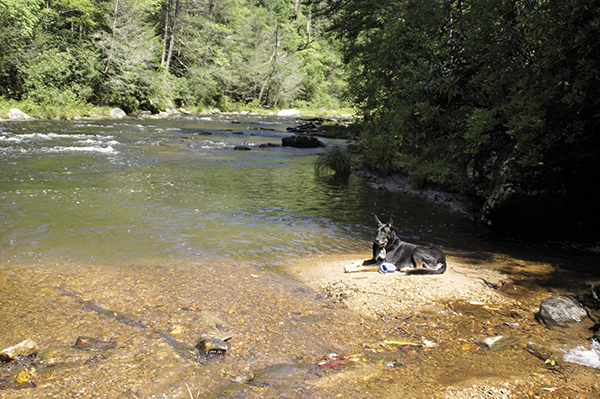
This peaceful portion of the Chattooga River sits at the base of Licklog Falls.
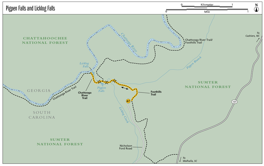
47 Pigpen and Licklog Falls
Ideal! This trail gives you two great waterfalls back to back. With a perfect camping area at Pigpen Falls and a fabulous flow straight out into the Wild and Scenic Chattooga River, Licklog Falls is yet another treat to be found along this amazing river.
Height: Pigpen Falls, 10 feet; Licklog Falls, 25 feet
Distance: Licklog Falls, 2.2 miles out and back (Pigpen Falls, 1.4 miles)
Trail surface: Hard-packed dirt
Approximate hiking time: 1 hour, 10 minutes
Blaze color: White
County: Oconee
Land status: National forest
Trail contact: Sumter National Forest, Andrew Pickens Ranger District; (864) 638-9568; www.fs.fed.us
Maps: DeLorme: South Carolina Atlas & Gazetteer: Page 16 G2; DeLorme: Georgia Atlas & Gazetteer: Page 16 B5
Finding the trailhead: From the junction of SC 107 and SC 28, drive north on SC 107 for 3.3 miles. Turn left onto Village Creek Road and travel 1.7 miles to a right turn onto Nicholson Ford Road just before the road makes a hard bend to the left (east). Follow Nicholson Ford Road for 2.2 miles to where it dead-ends. (Note: Along the way, Nicholson Ford Road becomes FS 2603.)
From the junction of SC 107 and SC 413 (Wiggington Road), drive south on SC 107 for 10.5 miles. Turn right onto Village Creek Road and follow the directions above.
GPS: N34 55.509 / W83 07.341
The Hike
The trail begins at the northeast end of the parking area by the trail information signpost. (Ignore the trail up the steps on the right or southeast side.) Head straight back (northeast) into the woods, following the white blazes. A wide variety of birdlife call this area home. Their songs serenade you before the sound of the creek drowns them out.
As you enjoy your surroundings, the trail makes a slow and steady descent until you arrive at a primitive campsite next to a creek. Pass the campsite and you soon come to a wooden footbridge over the creek. Cross the bridge and reach another primitive campsite. Continue straight ahead (west-southwest); the trail crosses another wooden footbridge. Pick up the easily followed trail on the other side as it follows the creek downstream.
This peaceful portion of the Chattooga River sits at the base of Licklog Falls.
Pass a small cascade on the left, head down the hill, and come to a fork at a sign reading Chattooga S. Go left (southwest) at this fork, following the trail downhill to a footbridge over the creek at the base of Pigpen Falls. This is a great place to have a creekside picnic or just sit a spell.
After basking in the beauty of Pigpen Falls, cross the bridge and head to the right, following the creek downstream. After hiking less than 0.25 mile you arrive at the brink of Licklog Falls. Continue downstream a bit farther. As the trail bends left (west), you will see an obvious side trail on the right (north-northeast) that leads you on a steep and strenuous scramble down to the river. Take this side trail all the way down to the river to get a view of Licklog Falls from the base.
Licklog Creek flows into Section 0 on the headwaters portion of the Wild and Scenic Chattooga River. The crown jewel of the Southern rivers, the Chattooga is most famous for its whitewater rafting but can also be appreciated from land. The Chattooga River Trail, which can be accessed here, is a fabulous 40-mile-long foot trail that follows the banks of the river and borders both South Carolina and Georgia.
Miles and Directions
0.0From the trailhead, hike northeast, following the white blazes straight back into the woods. The trail makes a slow and steady descent.
0.5Pass a primitive campsite next to a creek and continue hiking northwest to a wooden footbridge over the creek. Cross the bridge and come to another primitive campsite. Continue hiking straight ahead (west-southwest).
0.6Cross another wooden footbridge and pick up the easily followed trail on the other side. As you follow the creek downstream and west, pass a small cascade on the left and continue down the hill.
0.7Reach a fork at a sign reading Chattooga S. Go left (southwest) at the fork and follow the trail down to another footbridge over the creek at the base of Pigpen Falls (N34 55.715 / W83 07.749). (Option: Turn around and return to the trailhead for a 1.4-mile hike of about 45 minutes.) After enjoying Pigpen Falls, cross the bridge and head right (west), following Licklog Creek downstream.
0.9Arrive at the brink of Licklog Falls. Continue to follow the creek downstream.
1.0As the trail begins to bend to the left (west), an obvious side trail on the right leads you north-northeast on a steep and strenuous scramble down to the river.
1.1Arrive at the base of Licklog Falls, where Licklog Creek meets the mighty Chattooga River (N34 55.821 / W83 07.864). Return the way you came.
2.2Arrive back at the trailhead.
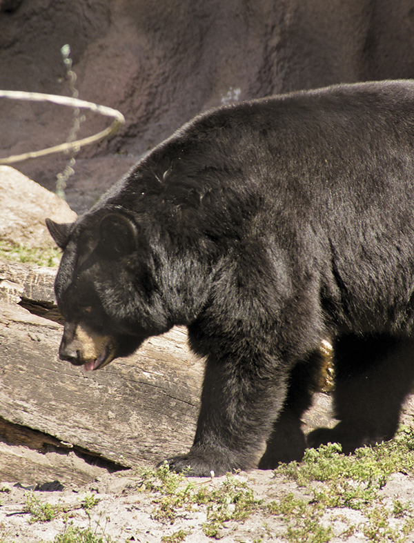
Ursus americanus, the American black bear, is unique to North America and roams throughout the mountains of Georgia and South Carolina.