50 Upper Sloan Bridge Falls, Lower Sloan Bridge Falls, and Hiker’s Peril
Fresh! As you make your way alongside the river, the cool and fresh waters beside you fill your heart with joy, enticing you to immerse yourself within them. One refreshing treat after another awaits you on this short, yet enjoyable, section of the famed Foothills Trail.
Height: Upper Sloan Bridge Falls, 45 feet; Lower Sloan Bridge Falls, 10 feet; Hiker’s Peril, 100+ feet
Beauty rating: Upper Sloan Bridge, very good; Lower Sloan Bridge, good; Hiker’s Peril, fair
Distance: 1.4 miles out and back
Difficulty: Mostly easy, with a steep and strenuous scramble
Trail surface: Hard-packed dirt
Approximate hiking time: 1 hour
Blaze color: White
County: Oconee
Land status: National forest
Trail contact: Sumter National Forest, Andrew Pickens Ranger District; (864) 638-9568; www.fs.fed.us
FYI: Trash cans, small restroom, trail information sign at parking area
Maps: DeLorme: South Carolina Atlas & Gazetteer: Page 16 E3; DeLorme: Georgia Atlas & Gazetteer: Page 17 A6; DeLorme: North Carolina Atlas & Gazetteer: Page 52 F2
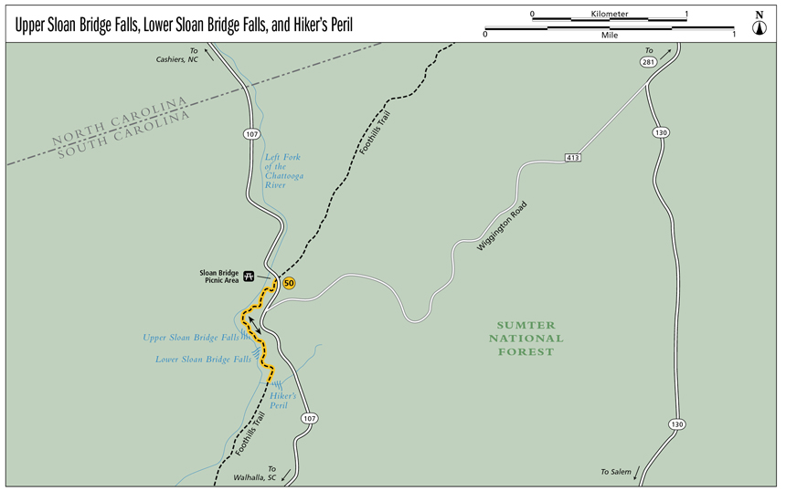
Finding the trailhead: From the junction of SC 107 and the North Carolina–South Carolina state line, drive south on SC 107 for 0.6 mile. Turn right into the unmarked paved parking area for Sloan Bridge Picnic Area.
From the junction of SC 107 and SC 413 (Wiggington Road), drive north on SC 107 for 0.15 mile. Turn left into the unmarked paved parking area for Sloan Bridge Picnic Area.
From the junction of SC 107 and SC 28, drive north on SC 107 for 14.0 miles. Turn left into the unmarked paved parking area for Sloan Bridge Picnic Area.
The trailhead is to the left, at the south end of the parking lot. GPS: N35 00.208 / W83 03.253
The Hike
From the trailhead the trail follows a portion of the white-blazed Foothills Trail. You immediately cross a small wooden bridge before coming to a trail information sign. Continue to follow the white blazes as the trail comes to and leaves the river from high above. After approximately 0.4 mile on the Foothills Trail, you arrive alongside the lively, three-tiered Upper Sloan Bridge Falls. A side path leads steeply to the base of the falls. This side trail is extremely steep and slippery—please use caution! Or, simply enjoy the view from the Foothills Trail.
From Upper Sloan Bridge Falls continue downstream for another 0.1 mile and get a good glimpse of Lower Sloan Bridge Falls from the trail above. Continue following the Foothills Trail for another 0.2 mile and arrive at a wooden footbridge over a portion of trail that is known as Hiker’s Peril. Although the hike along the river is pleasant, Hiker’s Peril itself is not a particularly attractive waterfall. As an option, you may consider skipping it and simply returning to the trailhead after viewing Lower Sloan Bridge Falls.
The banks of the river are so overgrown during spring and summer that viewing the falls from the Foothills Trail can be difficult during these seasons. I recommend hiking this one in wintertime, when the Upper and Lower Sloan Bridge Falls can be clearly viewed from the trail without having to scramble to the base.
This section of the 77-mile Foothills Trail is shared with the Fork Mountain Trail, which starts at streamside and makes its way to the top of Fork Mountain. At 3,294 feet, Fork Mountain is the tallest peak within the South Carolina tract of the Ellicott Wilderness and the second-highest summit in South Carolina.
Miles and Directions
0.0From the trailhead, hike south and immediately cross a small wooden bridge leading to a trail information sign. Continue to follow the white blazes as the trail comes to and leaves the river from high above.
0.4Arrive alongside lively, three-tiered Upper Sloan Bridge Falls (N35 00.016 / W83 03.360). A side path leads west, steeply down to the base. From Upper Sloan Bridge, continue following the river downstream and south.
0.5Arrive at Lower Sloan Bridge Falls (N34 59.942 / W83 03.306). You should be able to get a good glimpse of this one from the trail. Continue hiking south along the river.
0.7Arrive at the small bridge over Hiker’s Peril (N34 59.841 / W83 03.281). Return the way you came.
1.4Arrive back at the trailhead.
Options: To shorten this hike to 1.0 mile round-trip, you may opt to turn around at 0.5 mile after enjoying both the Upper and Lower Sloan Bridge Falls.
 The Foothills Trail stretches nearly 80 miles through upstate South Carolina and western North Carolina. This fabulous footpath leads past pristine preserves and wonderful waterfalls. As you make your way from the low country to the heights of Sassafras Mountain, a wealth of diversity awaits you.