Iron Age, Gallo-Roman, and Early Medieval France, the chronological period from the seventh century BC until the seventh century AD, saw many political and social changes that are reflected in the archaeological remains. For much of the period between 600 BC and the Frankish victory over the Romans in AD 486, the region of modern-day France was considered by ancient writers as “Gaul,” the term used in this chapter. Discoveries made recently through ongoing archaeological research, both new sites and reinterpretations of existing discoveries, are considered in chapter 6.
This chapter focuses on five topics, beginning with evidence of contact between Gaul and the Mediterranean world during the seventh century BC, including the foundation of the Greek colony of Massalia. Second, there is consideration of the evidence of indigenous settlement during the Iron Age, followed by consideration of the changes that were brought about by the Roman conquest of Gaul. A further theme is information regarding maritime trade shown by the discovery of Etruscan and Roman shipwrecks and, finally, archaeological evidence of the influx of non-Gallic people and the establishment of the Merovingian dynasty.
Greek Settlement in Gaul and Links with the Mediterranean World
The earliest contact point between Gaul and the ancient Mediterranean world was at the mouth of the Rhône, with late seventh-century BC Etruscan and Greek pottery found at the indigenous settlements of Saint-Blaise and La Couronne (both Bouches-du-Rhône), both to the northwest of Marseille. At this time, the majority of Greek pottery found at Saint-Blaise and La Couronne was from “East Greece” (modern-day Turkey); some was produced in Corinth on the Greek mainland.
Shortly after, in about 600 BC, the ancient Greek colony of Massalia was founded on the site of the modern-day city of Marseille (Bouches-du-Rhône), on the mouth of the river Rhône. It was established by the inhabitants of the East Greek city of Phokaia (modern-day Foça on the coast of western Turkey). The presence of Massalia facilitated trade to inland France as well as the development of local societies, including the introduction of cultivation of the vine. Pottery kilns have been found during excavation on the hill of Les Carmes, on the outskirts of Marseille, and examples of their output have been found outside the city, in the lower Rhône valley. The pottery includes a distinctive type of amphora, used for the transportation of wine, discovered at the modern-day town of Arles (Bouches-du-Rhône). The objects discovered in the area of the port of Marseille include both Etruscan and Greek pottery, although the foundation of Massalia led to a rise in the number of Greek imports at the expense of those from the Italian mainland. Archaeological evidence for the mechanisms of maritime trade between Gaul and the Etruscans is found on the shipwrecks off Cap d’Antibes (Alpes-Maritimes) and Grand Ribaud (Var), discussed later in this chapter.
The development of the modern city of Marseille means, however, that very little of Greek Massalia is visible today. Massalia was located on a hill to the north of modern-day Marseille’s Vieux Port (Old Harbor). However, excavations in 1977 in the area of the Bourse (Stock Exchange) building in advance of the construction of a shopping center indicated that occupation of Massalia extended along the northern side of the harbor. Excavations were undertaken in 2009 in the area known as the Panier, immediately to the north of the Vieux Port, in advance of the renovation of the Collège Vieux Port. The archaeologists discovered that the area was inhabited between 600 and 480 BC.
Massalia was a very prosperous city, minting its own coins in large numbers, marked MA∑∑A or MA, indicating “Massalia.” In addition, the city was sufficiently wealthy in the late sixth century BC to make a lavish offering in the panhellenic sanctuary at Delphi in Greece in the form of an elaborately decorated marble building conventionally called a “treasury.” By the second century BC, Massalia had acquired a city wall with stone foundations; one of its gateways with projecting towers, overlooking the inner harbor, was discovered in the excavations on the Bourse site.
Massalia founded its own colonies, one of which was Olbia, which was located at l’Almanarre on the Mediterranean coast, east of Marseille, and very close to the town of Hyères (Var). Olbia has been extensively excavated, initially from 1947 to 1951 and again from 1956 to 1971. Excavations recommenced from 1982 to 1989, and again between 2002 and 2008. According to ancient authors, along with Tauroention (sometimes identified with modern Saint-Cyr-sur-Mer), Antipolis (modern Antibes), and Nikaia (modern Nice), Olbia was founded as a colony by Massalia in the fourth century BC to help protect Massalia from maritime raiding. However, offshore excavations conducted by DRASSM between 1996 and 2000, which revealed the presence of sherds of Massaliot and Etruscan amphorae, indicate earlier occupation of the area, well before the foundation of the colony at Olbia in about 330 BC. Although now more than 150 meters from the sea, archaeology suggests that Olbia also served as a small trading port, with black-glazed pottery from Italy found in the settlement. Most apparent to the modern visitor are the walls with square towers, which had been strengthened in the second century BC. The single gateway into the town led to the ancient port, which is now silted up. In common with many other ancient Greek colonies, Olbia was built on a grid plan dividing the settlement into four blocks separated by wide streets, with a communal well in the center of the town. Olbia may have fallen under Roman domination in 49 BC, when Julius Caesar and his armies conquered the area. It is possible that at this time Olbia can be identified as Pomponiana, a settlement that is named in ancient accounts but has not been identified with certainty. Archaeologists have found evidence, however, that Olbia thrived during the Roman period, at which time three bath complexes were built, one of which was constructed in the first century BC inside the walls of the settlement. A new quay was built in the Roman period, remains of which are visible on the beach at modern-day l’Almanarre, seemingly to replace the earlier quay that had silted up.
Trade flourished elsewhere along the Mediterranean coast of pre-Roman Gaul, examples being at the coastal oppida (indigenous fortified settlements) of Saint-Blaise (Bouches-du-Rhône) and Pech Maho (Aude).
The ancient name of the settlement at the mouth of the river Rhône now known as Saint-Blaise is unknown, although it may be identified with the town called Mastrabala by the Roman author Avienus, writing in the fourth century AD. The Early Medieval settlement on the site, founded in the fifth century AD, was known as Ugium, and subsequently as Castelveyre from about AD 1200. The name Saint-Blaise was adopted in the sixteenth century AD.
The oppidum at Saint-Blaise was first excavated in 1935 by Henri Rolland, whose career is considered in chapter 4. Pottery finds from Saint-Blaise show contact with the Etruscan and Greek worlds. The archaeology indicates how the pattern of trade changed in the sixth century BC. Etruscan objects predominate between 600 and 550 BC, facilitated by the location of Saint-Blaise, including many amphorae used for the transport of commodities such as wine. However, from the middle of the sixth century BC, there is more evidence of Greek objects, both amphorae and pottery made in Athens, linked to the expansion of Massalia. The walls constructed in the Hellenistic period, in the second century BC, are the most impressive ancient remains that can be seen today at the site.
Pech Maho (Aude) was occupied continuously from the middle of the sixth century BC until the end of the third century BC. A particularly significant discovery that sheds light on the relationship between Pech Maho and other communities is a thin lead sheet, inscribed on both sides, found in an archaeological context dating to the fifth century BC. The piece of lead has been unrolled by specialist conservators and found to be 115 millimeters wide, 52 millimeters high, yet only 1.1 millimeters thick. The inscription on the outer side of the lead sheet is written in Etruscan, whereas that on the inner side is in Greek. The Etruscan inscription, which is incomplete, mentions Matalia, interpreted as Massalia. The more complete Greek inscription documents the purchase of a boat from the people of Emporion. This coastal town is known today as Empúries in the region of Catalonia in northeast Spain and famous in antiquity as a trading center founded by Massalia in the early sixth century BC. The text records that the purchaser also bought additional boats from elsewhere and passed over half a share of the boats to the writer of the inscription. The inclusion of the names of two witnesses to the transaction suggests that the document was not purely commercial in nature, but that the text also has formal legal aspects. It has been suggested that the document may have been written at Emporion and brought to Pech Maho by an itinerant merchant. The significance of the inscribed lead sheet lies in the light it sheds on trade along this part of the Mediterranean coast during the fifth century BC.
Further archaeological evidence of the expansion of the influence of Massalia along the Mediterranean coast from the late sixth century BC until the arrival of the Romans can be found at the coastal settlement of Lattes (Hérault), west of Marseille. Lattes originally was an indigenous community with links to the Etruscan world and became a trading outpost of Massalia from about 500 BC. Stone architectural remains have been found dating from the late fourth to the late third centuries BC.
In the period of Greek colonization, it is believed that Arles (Bouches-du-Rhône) was known to the Greeks as Theline. Although the later development of Arles has restricted our knowledge of this period of the town’s history, evidence of occupation during this era are finds of Greek pottery and amphorae from Massalia and of Phoenician origin, which would have been transported to the town by ship up the river Rhône, as well as fragments of a pre-Roman building in use from the sixth to the second centuries BC.
Agde (Hérault), on the coast west of Marseille, is believed to have been a colony of Massalia, founded in the late sixth century BC. Archaeologists have found circuit walls dating from the second century BC, built on foundations from the fourth to the third centuries BC. The Musée de l’Ephèbe, which opened in 1987, houses finds from underwater excavations from the coastal lagoons of the delta of the river Hérault and the Mediterranean Sea. The most famous exhibit is the bronze statue of a young man, 1.3 meters tall, after which the museum is named. It has been suggested that the statue, which was made during the Hellenistic period, may represent Alexander the Great. It was found in September 1964 on the bed of the river Hérault, opposite the cathedral at Agde. The statue probably was lost from a ship in the Roman period rather than having been displayed in ancient Agde. It was found in a very fragile condition with the forearms and feet no longer present. The left leg was not found until six months after the original excavation; the left arm was not attached until 2010.
Iron Age Gaul
Away from the Mediterranean coast, indigenous sites in Gaul continued to flourish, a notable example being the settlement on the hill of Mont-Lassois, which dominates the commune of Vix (Côte-d’Or) on the river Seine, about 195 kilometers from Paris. The settlement, which was inhabited from the Neolithic to the Merovingian period, was at its height during the sixth and fifth centuries BC. The settlement was excavated between 1929 and 1939, revealing not only locally produced objects, but also evidence of contacts with societies outside Gaul from the sixth century BC onward. In particular, archaeologists found amber and Athenian pottery decorated in the black-figure style.
The most spectacular discovery from the excavations that recommenced in 1947 was an elite female burial from the sixth century BC, found in 1953 at the foot of Mont-Lassois. At the time of excavation, it was the richest of all Iron Age tombs to have been found in France.
Close to the river Seine, the excavators investigated a large tumulus, some forty meters in diameter and between five and six meters high, in the center of which was a burial chamber. In one corner of the chamber was a large vessel of the type known as a volute krater, 1.64 meters high and weighing 208 kilograms, its style suggesting that it was made in one of the Greek colonies in southern Italy (figure 3.1). The vessel is made from bronze and able to be dismantled for transportation; some of the pieces were lettered to facilitate reassembly. The neck is decorated with a chariot procession, and the cast volute handles are decorated with gorgon’s heads. The vessel had a lid with a statuette of a woman, nineteen centimeters high, to serve as a handle, and the krater had been covered with matting made of organic fibers that has been partly preserved because of the wet conditions in the tomb, the result of its proximity to the river Seine. Other finds in the tomb were two Athenian pottery cups, one decorated in the black-figure technique that dates it to between 530 and 520 BC, and three Etruscan bronze vessels, imported from Italy.
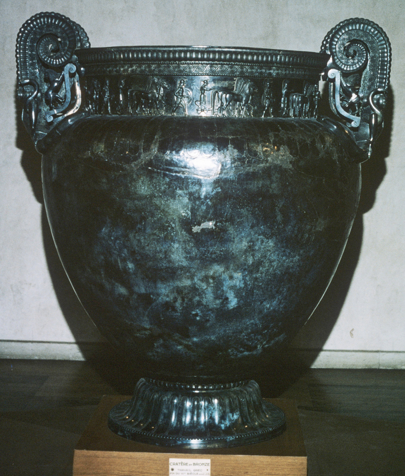
Figure 3.1. “Vix krater” from the female burial found at Mont-Lassois. Alamy
A chariot originally had been placed in the center of the tomb, indicated by the remains of iron and bronze fittings. The wheels of the chariot had been carefully removed before burial and stored in the tomb, with some of the wood from the hubs still preserved. Inside the chariot was a skeleton, which had deteriorated; only the skull was well preserved. The deceased was a woman aged about thirty, buried in an extended position, with more than twenty-five pieces of jewelry. She wore anklets and bracelets, one made of amber beads, and a gold torc-style necklace weighing 480 grams. Her clothes apparently had been held together with iron and bronze fibulas, a type of brooch. In particular, four of the bronze fibulas were very lavish, decorated with coral and red amber. The discoveries from the tumulus are on display in the Musée du Pays Châtillonais in nearby Châtillon-sur-Seine (Côte-d’Or).
Later excavations at Mont-Lassois have revealed more of the settlement. In particular, excavations in 2006 revealed a group of up to three buildings constructed in the late sixth century BC. The central building, thirty-five meters by twenty-one meters, had an apsidal end. Finds in the area include amphorae from Massalia and Athenian pottery. It is not surprising, perhaps, that the building has been associated in the popular press with the woman buried in the large tumulus and has led to the structure’s nickname of the “Palais de la Princesse” (palace of the princess).
Another tumulus at La Garenne, two kilometers from the lavish tomb at Vix, was excavated in the 1860s. It held a bronze cauldron, made in the artistic style known as “Greek Orientalizing,” dating to the middle of the sixth century BC. The cauldron, which stood on a tripod, is thirty-two centimeters high and seventy centimeters in diameter. Below the rim of the cauldron are four decorative projections known as protomai, in the form of griffins, one of which is slightly different in style and may have been replaced in antiquity. Another example of a griffin protome came to light in 1897 at Port-Thibault on the bank of the river Loire at Angers (Maine-et-Loire). Unfortunately, the protome has no archaeological context, as it was a chance find by a farmer.
Funerary practices in the Iron Age were diverse, reflecting not only changes in burial customs, but also the status of the deceased.
Excavations at the commune of Eterville (Calvados) have revealed an unusually large cemetery of around 150 burials. The cemetery was in use for inhumation burials from the sixth century BC until the start of the third century BC, and it is believed that it fell out of use because of a general change in funerary customs from inhumation to cremation, which by the second century BC had become the preferred practice.
A characteristic type of Iron Age funerary practice attested in northeastern and central France from the sixth century BC are a series of elite burials where the deceased, either male or female, was laid in a chariot. Around 140 burials of this type are known, although very few have been discovered undisturbed. One of these was found in 1873 in the commune of Somme-Bionne (Marne). The burial, dated to between 450 and 300 BC from the style of its finds, was re-excavated and recorded by Léon Morel. Morel, an amateur archaeologist who undertook many excavations of Iron Age, Gallo-Roman, and Merovingian sites in the Marne département, had been able to talk to the original excavators of the chariot burial at Somme-Bionne. The grave was 2.85 meters long, 1.8 meters wide, and 1.15 meters deep and lay at the center of a circle sixteen meters in diameter, surrounded by a ditch. Metal parts of the chariot survived, together with decorated harness fittings. The skeleton was in an extended position and was buried wearing a sword, knife, and gold ring. The grave offerings also included imported goods: an Athenian two-handled pottery drinking cup decorated on the inside in the red-figure technique and a bronze flagon of the characteristic Etruscan shape known as a “Schnabelkanne,” alongside a locally made pedestal vase, its surface red-slipped. Many of the finds, including the vessels, are now in the collection of the British Museum in London, acquired in 1901. The fifth century BC chariot burial from Lavau (Aube) will be discussed in chapter 6.
An extremely unusual type of burial from the late Iron Age was discovered in 2002 at the oppidum site of Gondole in the commune of Le Cendre (Puy-de-Dôme) during construction of a bypass south of the city of Clermont-Ferrand (Puy-de-Dôme). Around three hundred meters outside the wall of the oppidum, a communal burial of eight males, of whom seven were adult and one was an adolescent, accompanied by their horses, was discovered, their bodies arranged in two rows of four. No weapons, harness elements, or personal objects were found in the burial. The horses were small, measuring only 1.2 meters at the shoulder, which suggests they were local animals. The project to excavate Gondole, which was much less known than the neighboring oppida of Gergovie and Corent (both Puy-de-Dôme), took place from 2002 until 2005. It was discovered that Gondole, which occupied a strategic position at the confluence of the rivers Allier and Auzon, extended over an area of seventy hectares, both inside and outside its walls. Excavation of an area outside the walls of Gondole revealed that it was occupied by artisans, with evidence of pottery kilns and forges.
Some elements of Iron Age material culture are particularly distinctive, and of note are discoveries of three helmets dating to the fourth century BC. The most elaborate was found in the Grotte des Perrats in the commune of Agris (Charente). It consisted of an iron cap covered with bronze bands, above which was a thin layer of gold, decorated with coral. The first fragments of the helmet were found in 1981 with further discoveries in 1983 and 1986, although the helmet still is incomplete. Now restored, it is in the Musée d’Angoulême (Charente). Less elaborately decorated is a helmet found in 1876 by Paul du Chatellier at the oppidum of Tronoën, in the commune of Saint-Jean-Trolimon (Finistère). The fragmentary helmet, in the collections of the Musée d’Archéologie nationale, was made using a similar technique of an iron cap, covered with a thin layer of bronze, decorated with coral on the top of the helmet and on the surviving cheek piece. Perhaps slightly later in date is the helmet found in 1841 at the commune of Amfreville-sous-les-Monts (Eure). Now in the Musée d’Archéologie nationale, it was restored between 1981 and 1982. The helmet is decorated with a wide, single band of gold foil and red enamel inlay.
A typical pre-Roman archaeological site is the oppidum of Ensérune (Hérault), in the commune of Nissan-lez-Ensérune. The site was discovered in 1915, initially producing remains from the fourth and third centuries BC. Additional excavation showed that the site initially was occupied earlier, from the sixth century BC. The hill fort was destroyed at the end of the third century BC, rebuilt and regained prosperity after the arrival of the Romans and the foundation of a colony in Narbonne in 118 BC, but its population declined from the first century AD onward. The site museum houses finds from the sixth century BC onward, including pottery that was imported as well as produced locally. Inscriptions in an ancient language sometimes described as “Iberian” have been found at Ensérune, indicating links with the area, which is now modern-day Spain. A significant discovery was a drinking cup, made in Athens between 425 BC and 400 BC and decorated in the red-figure technique with a scene of the myth of Kephalos and Procris painted inside the cup. Some of the original remains at Ensérune were left in situ, including dolia (large storage vessels sunk into the ground), the remains of columns, and wall foundations.
Other elements of indigenous Gallic society, however, show no evidence of Greco-Roman influence, most notably ritual practices. Enclosures associated with Gallic ritual activity have been found at several locations in France, with the best-studied being at Gournay-sur-Aronde (Oise) and Ribemont-sur-Ancre (Somme), both in northern France. At Gournay-sur-Aronde, archaeologists found a rectangular enclosure built around 300 BC and in use during the following three hundred years. Pits in the enclosure contained animal bones, which are believed to have been from sacrifices. In addition, about two thousand iron weapons were deposited in the ditch surrounding the enclosure. Ribemont-sur-Ancre, approximately seventeen kilometers east of Amiens (Somme), produced deposits of human skeletal remains from somewhere between 200 and 250 individuals. The deceased mostly were young men, some of whom exhibited injuries caused by bladed weapons. No skulls, ribs, or spines were found among the skeletal remains, and cut marks on the neck vertebrae suggest that the deceased were decapitated. Large amounts of iron weapons, some of which are displayed in the Musée de Picardie in Amiens, were also found at Ribemont-sur-Ancre, which is believed to date from the third century BC. The ossuary was covered in the Roman period by a sanctuary, discussed later in the chapter.
Roman Gaul
The second century BC saw major political and social changes, as the conquest by the Romans began, and the area became part of the Roman provinces that comprised Gaul. These encompassed not only modern-day France, but also northern Italy, Belgium, Luxembourg, western Switzerland, and the parts of the Netherlands and Germany that lie west of the river Rhine. Roman armies first entered southeastern Gaul in 154 BC to help with the defense of Massalia against invaders. The Romans conquered this area from 125 BC; in 121 BC they annexed the coastal area from modern-day Montpellier (Hérault) to the Pyrenees. The Romans gradually took over the area that is now modern-day France, governing the area for the next five hundred years. This section will consider archaeological evidence from the Roman provinces of Gallia Narbonensis, Aquitania, and Gallia Lugdunensis.
The first province north of the Alps was named by the Romans Provincia Nostra, meaning “Our Province.” The term Provincia Nostra has survived in the name “Provence,” the eastern part of Provincia Nostra, the western part being located in what is now the modern region of Languedoc, both southern France. The province was renamed Gallia Narbonensis by the emperor Augustus in 27 BC after its capital Colonia Narbo Martius, the modern-day town of Narbonne (Aude), which had been a Roman colony founded in 118 BC. Colonia Narbo Martius was located in a strategic position; the settlement had access to the sea as well as to the interior via the river Aude and was at the junction of two important Roman roads. The Via Domitia, built in the second century BC, linked Italy to Spain; and the Via Aquitania started in Narbonne and ran west to the Atlantic coast through Toulouse (Haute-Garonne) to Bordeaux (Gironde), known to the Romans as Tolosa and Burdigala respectively.
Subsequent development means that very little of Roman Narbonne is visible today, although part of an underground warehouse, known as a horreum, dating to the late first century BC, can be visited (figure 3.2). Other remains from Roman Narbonne can be seen at the site known as the Clos de la Lombarde, just north of the town. Excavations from 1973 have revealed houses, workshops, and baths from the Roman period, as well as an early Christian church. The area was a large residential quarter during the Roman period, with some streets lined with porticos undoubtedly once housing small shops. Several of the houses have produced wall paintings from the first and second centuries AD, particularly House IV, including a depiction of Phaeton driving the chariot of his father, Helios, the sun god. Other paintings were found in the “House with the Large Triclinium” and, most notably, the “House of the Genius.” The House of the Genius was built in the first century AD and expanded in the third century AD with the addition of a second story. The house had several mosaic floors made from black and white tesserae, and wall paintings showing Winged Victory, Apollo, and the Genius, carrying a cornucopia and pouring a libation, which gives the villa its modern name. The houses were abandoned in the third century AD and a church built over their remains in the fourth century AD. A baptistery has been found, together with several burials, including an amphora containing the burial of a child. A large number of objects from Roman Narbonne, including the wall paintings from the houses at Clos de la Lombarde, are in the collection of the Musée archéologique at Narbonne, housed in the eleventh- to twelfth-century AD archbishop’s palace.
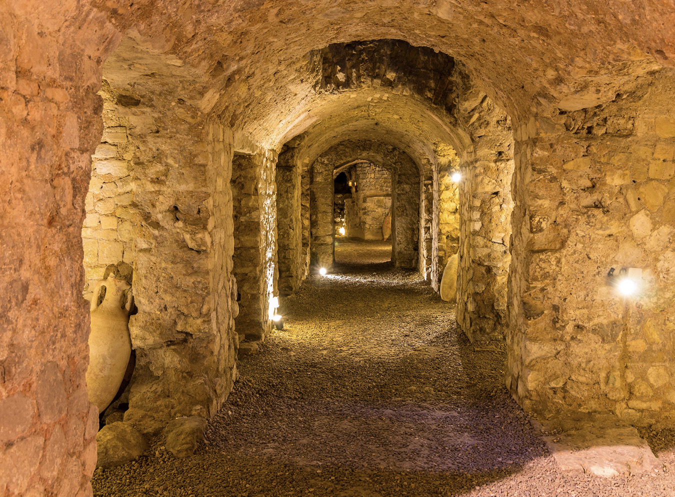
Figure 3.2. Horreum (underground warehouse), Narbonne. istock, 467276787
Part of the Via Domitia in the center of the old town of Narbonne, close to the Town Hall, was revealed in 1997 and is on display in situ. A longer section of the Via Domitia can be seen at Ambrussum, in the commune of Villetelle (Hérault), where it passed through the settlement (figure 3.3). Ambrussum originally was founded as an oppidum, although occupation continued after the Romans arrived in the area and the settlement was remodeled. Ambrussum was recorded as a trading post on the Antonine Itinerary, a list of distances along various Roman roads that was compiled around the third century AD.

Figure 3.3. Roman road known as the Via Domitia at Ambrussum. Alamy
There is little physical evidence of the military campaigns that led to the final conquest of Gaul by Gaius Julius Caesar, known as the “Gallic Wars.” These took place between 58 and 52 BC and are recorded by Caesar in his Commentarii de Bello Gallico (Commentaries on the Gallic War). Caesar documented his final struggle against Vercingetorix, who by 52 BC had become the leader of all of the indigenous tribes from the river Seine in the north to the river Garonne in the southwest. Caesar wrote that the struggle against Vercingetorix culminated in the final battle at Alésia, the capital of the Mandubii tribe, a hill fort where Vercingetorix and his warriors had taken refuge. The site of Alésia was not known and, as discussed in chapter 1, in 1864 the French Emperor Napoleon III issued an official decree that Alésia was located on Mont-Auxois, in the commune of Alise-Sainte-Reine (Côte-d’Or). Indeed, the presumed site of the battle is overlooked today by a colossal statue of Vercingetorix, commissioned in 1864 by Napoleon III from the sculptor Aimé Millet. Standing on a stone base 7 meters high, designed by the architect Eugène Viollet-le-Duc, the statue, covered in sheet copper, stands 6.6 meters high and, accordingly, dominates the landscape.
More recently, survey and excavations were conducted at Alise-Sainte-Reine between 1991 and 1997 by a Franco-German team led by Michel Reddé and Sigman von Schnurbein, their objective being to confirm that Alésia and Mont-Auxois were the same place. Their excavations revealed the traces of a Gallo-Roman town, which prospered largely as a result of the activities of bronze workers, before being abandoned in the fifth century AD. Buildings at Alise-Sainte-Reine include a monument to Ucuestis, a Gallic deity linked with metallurgy; and a bronze vase inscribed with the names of Ucuestis and his consort, Bergusia, had been found during excavation of the monument in 1908. Controversy still surrounds the identification of Mont-Auxois as Alésia, which will be discussed more fully in chapter 5.
A section of the Roman fortifications that would have surrounded the hill fort have been reconstructed at the Muséoparc Alésia in Alise-Sainte-Reine. These reconstructions are based on the account by Julius Caesar and the excavations undertaken by Napoleon III, and give the visitor an impression of the work necessary to conduct a siege in the Roman period.
Other evidence from the period of the Gallic Wars can be found close to the oppidum of Liercourt-Erondelle (Somme). Aerial photography has suggested an enclosure with a ditch near the oppidum, and the area also has produced Iron Age pottery and coins. It is unclear whether the enclosure housed a garrison consisting of Roman or Gallic mercenaries guarding the hill fort, or whether the occupants were a group protecting the hill fort after expelling the local Gauls. Although other enclosures in the Somme département, identified as “camps,” sometimes are associated with Caesar’s Gallic Wars, they are likely to be later in date.
Bibracte, twenty-five kilometers from the modern-day town of Autun (Saône-et-Loire), was an oppidum on Mont Beauvray. Bibracte was capital of the Aedui tribe from the end of the second century BC and, at its height, had an estimated population between five thousand and ten thousand inhabitants. The Aedui were treated favorably by the Romans and, accordingly, had contact with the Roman world before the conquest of this part of Gaul in 52 BC, undoubtedly aided by its strategic position on an important trading route along the rivers Loire and Saône. This is apparent from the discovery of amphorae imported from Italy that would have contained wine. Despite being the place where Vercingetorix was made leader of the indigenous Gallic tribes, the status of Bibracte meant that it was left unscathed after the Roman victory at Alésia; and, indeed, Julius Caesar wrote his Commentarii de Bello Gallico (Commentaries on the Gallic War) at Bibracte. The foundation of Augustodunum (modern-day Autun) in about 15 BC led to the gradual abandonment of Bibracte, as the need for the protection given by its location on Mont Beauvray became unnecessary.
The first excavations at Bibracte were funded by Napoleon III and conducted by Jacques-Gabriel Bulliot from 1867; they were continued by his nephew Joseph Déchelette from 1897 until 1901 and again in 1907. On Déchelette’s death in 1914, archaeological work ceased at Bibracte. However, a major research project began in 1984 involving a multinational team. Modern-day visitors to the archaeological park at Bibracte can see public buildings, houses, workshops, and fortification walls from the Gallo-Roman town, extending over an area of two hundred hectares. The reconstructed fortifications extend 5.2 kilometers around the Gallo-Roman site and, with their main gateway, were constructed in the first century AD. An earlier fortification, still covered, was built in the second century BC when Bibracte was founded and extends seven kilometers around the site.
Once Gaul was finally under Roman administration as a consequence of Julius Caesar’s victory in the Gallic War, “romanization” began. Romanization was the gradual adoption by at least the upper echelons of the indigenous Gallic society of the customs, types of artistic and architectural expression, technology, style of dress, Latin language, and religious beliefs that are referred to as “Gallo-Roman.” Although the Gallo-Roman people retained their cultural and social identities by remaining members of their local indigenous tribe, they could become citizens of the Roman Empire, including serving in the Roman army. Indeed, by the second century AD, many of those serving in the Roman army were from Gaul.
Striking evidence of the fusion of Roman and indigenous Gallic culture can be seen on a statue known as the Vachères Warrior, named from its findspot in the commune of Vachères (Alpes-de-Haute-Provence). This is now in the Musée Lapidaire, the archaeological collection of the Musée Calvet, in the town of Avignon (Vaucluse). Dating to the later first century BC, the warrior is identifiable as an indigenous Gaul by the torc around his neck; he wears the dress and equipment of a Roman soldier. Accordingly, this demonstrates that the Gallic elite had the chance to advance in Roman society, yet retain their status in the local community.
The first Roman emperor to have been born in a province was Claudius, who was born on 1 August 10 BC in Lugdunum (modern-day Lyon) and reigned from AD 41 until his death in AD 54. It was during the reign of Claudius that members of the Gallo-Roman elite were first admitted to the Senate in Rome, a trend that continued throughout the second century AD.
A wealth of sites that have visible archaeological remains from the Roman period are in the south of France, in particular in the modern-day départements of Gard, Vaucluse, and Bouches-du-Rhône. The most notable are the towns Nîmes (Gard) and its nearby aqueduct bridge of Pont-du-Gard, Arles, Glanum/St. Rémy (both Bouches-du-Rhône), and Orange (Vaucluse).
The town of Nîmes (Gard), known in antiquity as Nemausus, was the capital of the Volcae Arecomici tribe before its conquest by the Romans and incorporation into the province of Gallia Narbonensis in the second century BC. The town further developed in the reign of the emperor Augustus (27 BC to AD 14), and was honored with the name Colonia Augusta Nemausus.
The Maison Carrée (translated as Square House), a name first applied to the building in 1560, stood in what originally would have been the Roman forum in Nîmes, of which no other buildings remain (figure 3.4). The Maison Carrée, which dates to the Augustan era, was a temple whose exceptional preservation is the result of subsequent reuse for a variety of functions.

Figure 3.4. “Maison Carrée,” Nîmes. istock, 628563362
The temple is typically Roman in architectural form, with a staircase at the front and the whole building on a high podium. Built from local limestone, originally it would have had porticos on three sides; they are no longer present. Temples in this style are relatively rare in Roman Gaul, another example being the well-preserved temple dedicated to Augustus and Livia in Vienne (Isère). The columns of the Maison Carrée are in the Corinthian order, the most elaborate of the Greco-Roman architectural orders, decorated with stylized acanthus leaves and scrolls. There is a combination of freestanding columns at the front of the temple and engaged columns part way down the sides and back. The Corinthian column capitals are carved in three different styles, suggesting that three separate teams of artisans were employed. Two lines of small holes on the facade of the Maison Carrée indicate the position of the dedicatory inscription made in individual letters, probably made from bronze, but now no longer present. This indicated that the temple was an example of the imperial cult, dedicated to Gaius Caesar and Lucius Caesar, who Augustus had intended to be his heirs. They were the sons of Marcus Vipsanius Agrippa, appointed governor of Transalpine Gaul in 39 or 38 BC by Octavian before he took the name of Augustus. The titles of Gaius Caesar and Lucius Caesar in the inscription establish a date of around AD 1 for the construction of the temple. The Maison Carrée was much admired by the U.S. president Thomas Jefferson and influenced the design by Jefferson and Charles-Louis Clérisseau of the State Capitol building in Richmond, Virginia.
The amphitheater at Nîmes, dating to the later first century AD, was built of locally quarried stone and would have held twenty-four thousand spectators (figure 3.5). It is also extremely well preserved due to its later reuse. After the ban on gladiatorial games in AD 404, the arena was not used until the twelfth century, when a chateau was built inside and occupied by the Chevaliers des Arènes. The chateau was occupied until the fourteenth century, when the inhabitants moved to a new building on the site of the town gate known as the Porte d’Auguste. A village, including two churches, subsequently developed inside the amphitheater, which by the eighteenth century had approximately seven hundred inhabitants living in fifteen hundred houses. It was not until the early nineteenth century that the last remaining houses were demolished and the amphitheater restored to its appearance in the Roman era.

Figure 3.5. Roman amphitheater, Nîmes. istock, 521208624
The town was fortified in the reign of the emperor Augustus, although the only remains are the Porte d’Auguste, which was one of the main gates to the town; and the Tour Magne, which stands on Mont Cavalier, the highest point of the city (figure 3.6). Although the construction of the Tour Magne dates from the Roman period, it incorporates the remains of an earlier Iron Age monumental tower.

Figure 3.6. Tour Magne at Nîmes. istock, 175964858
An essential element of Roman towns was the provision of a good water supply. Roman Nîmes was served by an aqueduct whose remains are well preserved. Built in the first century BC, it carried water from the town of Uzès (Gard) at the source of the river Eure, a distance of fifty kilometers, to Nîmes. The route of the aqueduct involved a combination of masonry structures, channels, and tunnels to maintain a gradual falling gradient. The most famous structure is the aqueduct bridge now known as the Pont-du-Gard, which spans a gorge above the river Gardon (figure 3.7). At its highest point it is forty-nine meters above the river, making the Pont-du-Gard the highest surviving bridge in the Roman world. The Pont-du-Gard was constructed with three tiers of arches, comprising six spans on its lowest level, eleven on its middle level, and thirty-five (originally forty-seven) on its upper level. A well-preserved example of the way the water was distributed throughout a Roman town is found at Nîmes, where the “castellum divisorium” is preserved. This is a circular reservoir at the end of the aqueduct that enabled the water flow to be regulated as it was distributed through lead pipes to the bathhouses, fountains, and lavish private houses in Nîmes. The Pont-du-Gard was also a landmark in later periods, and engravings of initials and tools were made by the “compagnons,” the traveling stonemasons who were apprenticed to master artisans, to signal the symbolic end of their travels. These engravings, the earliest of which is dated 1631, can still be seen on the east side of the Pont-du-Gard.
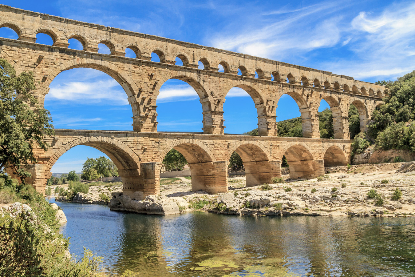
Figure 3.7. Roman aqueduct-bridge known as Le Pont-du-Gard. istock, 159314951
The town of Arles (Bouches-du-Rhône), known in the Roman period as Arelate, is situated on the river Rhône and was at the end of the Via Julia Augusta that ran from Placentia, modern-day Piacenza in Italy. The coastline has altered since Roman times, and modern day Arles is further from the sea than its Roman counterpart. Impressive surviving Early Roman monuments include a theater, forum, and, most notably, a cryptoporticus and a very well preserved amphitheater. The cryptoporticus was built in the first century BC and is a series of subterranean galleries in the form of three double parallel tunnels that form the substructure of the Roman forum. Although the usual suggestion for the use of a cryptoporticus is for the storage of grain, the galleries at Arles are too damp for this purpose, and the possibility exists that they were used as barracks for public slaves. The amphitheater was built in the first century AD and was capable of holding twenty thousand spectators. Its good preservation is a result of later use; in the post-Roman era the amphitheater was used as a fortress, with the addition of towers in the medieval period. The area became residential, which continued until the late eighteenth century. Restoration of the amphitheater began in 1825 at the instigation of Prosper Merimée, the author of the novella Carmen, then Inspecteur général des monuments historiques. It remains in use today for the performance of plays, concerts, and bullfighting.
Evidence of food production in the Arles region in the Roman period is found at the watermill complex at Barbegal, twelve kilometers north of Arles. The remains are of a multiple mill with sixteen overshot waterwheels arranged as two parallel sets of eight, and of an aqueduct that provided water from the Alpilles hills to Arles. The waterwheels were used as the source of power for a flour mill, which may have been employed as a sawmill when it was not grinding corn. The mill was in use from the end of the first century AD until the end of the third century AD, and estimates are that it was capable of producing 4.5 tons of flour per day, enough to provide bread for ten thousand people. The Musée de l’Arles et de la Provence antiques displays a reconstructed model of the Barbegal water mill.
In AD 395 Arles became the seat of the Praefectura praetorio Galliarum (Praetorian Prefecture of the Gauls), which was the catalyst for a new phase of building, particularly the Baths of Constantine. This was a large bath complex, of which only the northern area has been excavated.
The necropolis of Alyscamps is situated a short distance outside the old town of Arles, where the Via Julia Augusta entered the town. By the fourth century AD the necropolis had several thousand tombs and was used not only by the elite families of Arles, but also by those in the surrounding area. Some of the sarcophagi from the necropolis are now on display in the Musée de l’Arles et de la Provence antiques. The artists Vincent van Gogh and Paul Gauguin visited Alyscamps in October 1888, and both painted the same view of the cemetery to compare their work.
The remains of Glanum, originally a Gallo-Greek and then Roman town set in the Alpilles hills close to the modern town of St. Rémy (Bouches-du-Rhône), were excavated by Henri Rolland between 1928 and 1933, and again in 1942. The excellent preservation of the town is due in part to Glanum’s abandonment in the third century AD in favor of St. Rémy. Originally founded in the sixth century BC, contact between Glanum and the Greek colony of Massalia is reflected in the civic architecture, particularly a building resembling a Greek bouleuterion (council chamber), an agora (marketplace), and stone-built houses with peristyle colonnades. The romanization of Glanum is visible in its monuments, particularly its triumphal arch and the mausoleum of the Julii (figure 3.8). The triumphal arch is one of the earliest known examples in France, dating to the latter part of the reign of the emperor Augustus. The upper part of the arch, including its inscription, is no longer present. The surviving part of the arch is a Roman propaganda statement, its sculpture showing images of defeated Gallic prisoners. The mausoleum of the Julii is technically a cenotaph, as it has no burial chamber. It is a very imposing structure, being eighteen meters high and built in three stories, with scenes of mythical combat sculpted on its lowest section. The mausoleum was erected between 30 and 20 BC by three brothers of a Gallic family who had been granted Roman citizenship by Julius Caesar and built in honor of the brothers’ father and grandfather. The monument, which stands close to the triumphal arch alongside what was then the main road into Glanum, would have proclaimed the status of the deceased and was an indication of the wealth of the town.

Figure 3.8. Roman arch and Mausoleum of the Julii, Glanum. istock, 458250481
The town of Orange (Vaucluse) is noted for its Roman remains, particularly the well-preserved theater and triumphal arch (figure 3.9). Roman Orange was founded in 36 BC on the site of an earlier Gallic settlement. Known to the Romans as the Colonia Julia Firma secundanorum Arausio, it was home to veterans of the second Legion. The theater was built in the first century AD during the reign of the emperor Augustus. The theater’s most notable architectural feature is its scaenae frons (rear wall), which survives to a height of thirty-seven meters. King Louis XIV (reigned 1643–1715) was reported to have said during a visit to Orange, “C’est la plus belle muraille de mon royaume” (It is the finest wall in my kingdom). The Edict of Thessaloniki in AD 380 established Nicene Christianity as the official religion of the Roman Empire. Accordingly, in AD 391 the emperor Theodosius closed the theater, in common with those elsewhere, and Orange became a bishopric. As at Arles, restoration of the theater began in 1825 at the instigation of Prosper Merimée. The first Roman Festival was held at the theater in 1869, renamed the Chorégies from 1902, and continues today, primarily as a festival of opera. The Roman triumphal arch at Orange is more than nineteen meters high, has three spans, and is decorated lavishly with military themes of battle and the spoils of victory. The date of the arch has been the subject of much debate. Its initial construction traditionally is dated to the reign of Augustus to honor both those who fought in the Gallic Wars and the second Legion. The arch seemingly was reconstructed in AD 27 by the emperor Tiberius, as evidenced by an inscription, to celebrate the victories of Germanicus over the local tribes in the Rhineland. However, another opinion is that the triple arch would indicate a later date, perhaps in the late second century or early third century AD. The arch was incorporated into the city walls of Orange in the medieval period and restored as a freestanding monument in the middle of the nineteenth century.

Figure 3.9. Roman arch at Orange. istock, 479520446
Away from the major towns in southern France are a number of Roman archaeological sites.
The Trophée des Alpes, also known as the Tropaeum Alpium, is a prominent Roman monument, located at La Turbie (Alpes-Maritimes), above modern-day Monaco (figure 3.10). It is situated at the highest point on the Via Julia Augusta, the main Roman coastal road from Italy to Gaul. The Trophée des Alpes was erected by the emperor Augustus between 7 and 6 BC. It celebrates the conquest in 15 BC by Tiberius and Drusus, the stepsons of Augustus, of forty-five tribes described on the monument’s inscription as “Alpine.” The Trophée des Alpes, which dominates the landscape and is visible from the sea, serves as a tangible statement of the power of the Roman Empire.
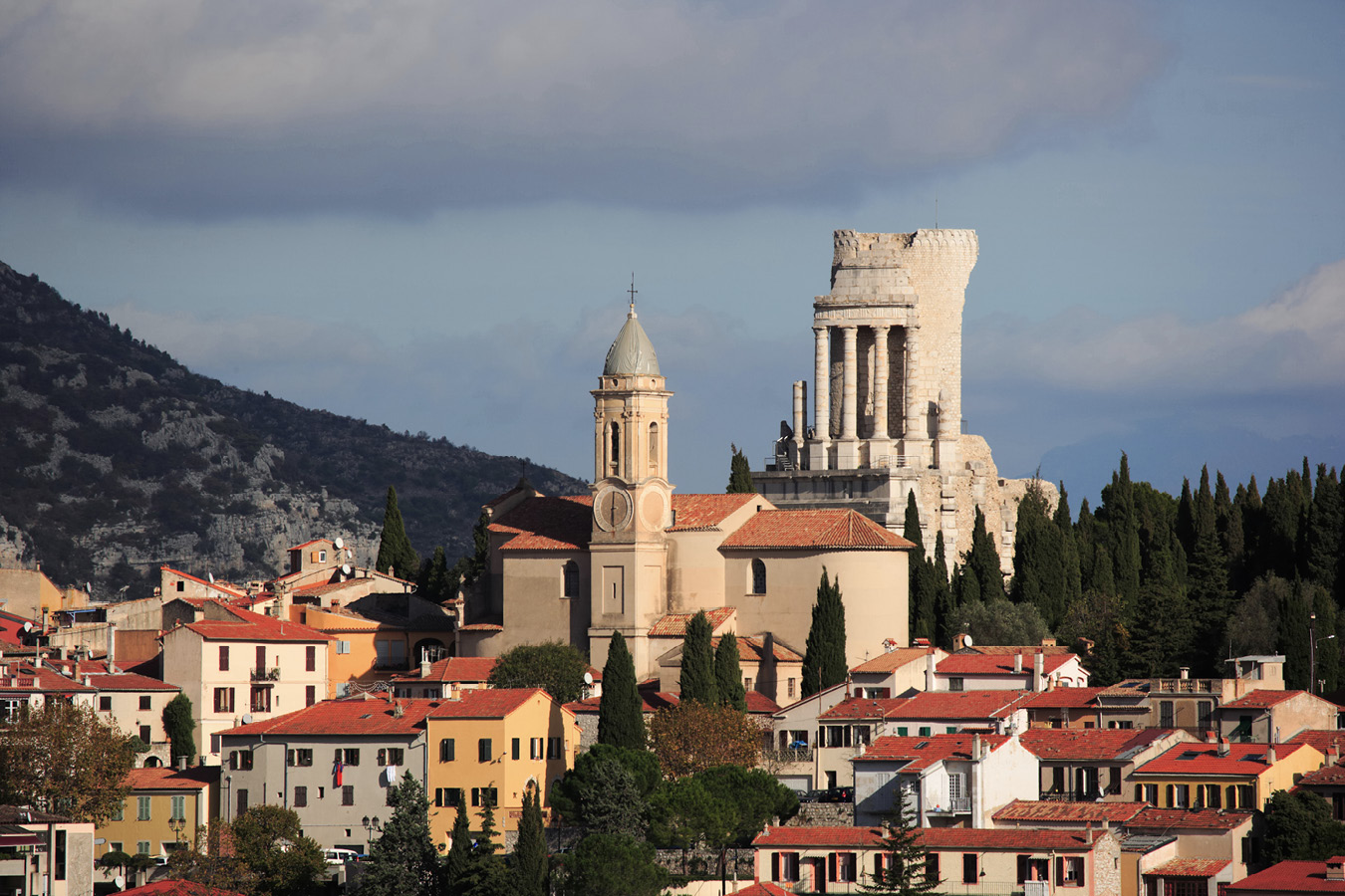
Figure 3.10. Le Trophée des Alpes, La Turbie. istock, 144956354
An unusual reminder of the Gallo-Roman era is found at the coastal settlement of Saint-Cyr-sur-Mer (Var), east of Marseille, where a villa was built in the first century AD in a very picturesque location. The villa site is now incorporated in the Gallo-Roman Museum of Tauroentum, although no clear evidence links the modern-day Saint-Cyr-sur-Mer with the ancient city of Tauroention (Roman Taurontum). Tauroention is recorded historically as a Greek trading post active from the fifth century BC and the site of a decisive naval battle between Caesar and Pompey for the control of Massalia. The location of the villa was known during the reign of King Louis XIV (1643–1715), who commissioned a survey of the site, but excavation only was begun in the 1920s, under the direction of Antoine Charras. The importance of the site was recognized in 1926, when it was classified as a historic monument. The site museum, constructed on top of the villa, opened in 1966. The highlight is the villa itself, although the museum also displays objects found on site, including amphorae, glass, and coins. A group of graves of different types includes a rare “house tomb.” A Roman villa on the coast, such as this, similar to the type known from the Bay of Naples, is a very unusual discovery in France, the more usual villa being inland. The villa at Saint-Cyr-sur-Mer had a long open colonnade consisting of eighty granite columns, facing the sea, and three of its rooms had mosaic floors. It has been suggested that the abandonment of the villa was hastened by an earthquake in the third century AD.
Evidence of Gallo-Roman religion comes from the important rural healing sanctuary at Source-Seine (Côte-d’Or) in a small, enclosed valley in the Châtillon plateau to the northwest of the town of Dijon. Plausibly, it originated as an indigenous sanctuary that further developed in the Roman period, from the first century AD until the end of the fourth century AD. The first Gallo-Roman objects were found on the site in the eighteenth century, and excavations were conducted between 1836 and 1843 under the direction of Henri Baudot. Baudot’s excavations uncovered the foundations of the sanctuary, which consisted of baths and a temple adjacent to the spring that is the source of the river Seine, as well as votive offerings. A find in one of the rooms of the baths was a pot inscribed with the name of the goddess Dea Sequana, the goddess of the river Seine, containing 120 anatomical votive offerings in the forms of eyes, breasts, and sexual organs made from bronze coated with gold or silver. In addition, wooden votive offerings have been preserved through the waterlogged environmental conditions. These consisted of a group of anatomical votives and complete human figures, likely to have represented worshippers. A statuette, thirty centimeters tall, of a female standing in a boat, is likely to be a representation of the goddess Sequana. The statuette now is housed in the Musée archéologique in Dijon (Côte’d’Or).
Another significant rural Gallo-Roman sanctuary was located at Ribemont-sur-Ancre (Somme), whose pre-Roman ossuary was discussed earlier in the chapter. The sanctuary is located on the slope of the valley of the river Ancre. At the highest point of the site was a large temple, with other buildings at a lower level, including a bath complex and theater seating three thousand spectators. Some of the stone sculpture from the temple is on display at the Musée de Picardie in Amiens (Somme).
Modern-day La Graufesenque (Aveyron) and Lezoux (Puy-de-Dôme) in southern and central France were the most important pottery production centers in the Roman Empire. They were known for the type of pottery technically called terra sigillata, colloquially referred to as “Samian ware.” East Gaulish terra sigillata was made in what is now Germany. The earliest type of terra sigillata was made at Condatomagus (literally “the market where the rivers meet”), today known as La Graufesenque, on the outskirts of the town of Millau, on the small plain at the confluence of the rivers Tarn and Dourbie. Condatomagus was ideal for the production of pottery on a large scale, having access to good-quality clay, plentiful water, and large quantities of wood from the forests on the Causses, the series of limestone plateaus situated to the east of Millau.
Excavations at La Graufesenque took place in 1950, again from 1972 until 1982, and have provided useful evidence of the practicalities of the production of terra sigillata. The kilns at the site were in use between 10 BC and AD 150, with the major period of pottery export being between AD 40 and AD 100. It has been calculated that approximately six hundred potters would have worked at Condatomagus during its period of pottery production, about two hundred at any given time. Condatomagus is estimated to have had about fifty kilns in an area of ten hectares, although apart from the “grand four” (large kiln), few are visible today as only 2 percent to 3 percent of the site has been excavated. The Musée de Millau et des Grands Causses in the eighteenth-century Hôtel de Pégarolles houses displays that include a reconstructed kiln, examples of the different shapes of pottery vessels, and large quantities of “wasters,” which are defective vessels that had been discarded. Interestingly, the “wasters” include pottery vessels stamped by different makers but fired in the same kiln.
The other major production center in France of terra sigillata was Lutosus, in the modern-day commune of Lezoux, near the city of Clermont Ferrand (Puy-de-Dôme). Many years of excavation have revealed hundreds of kilns whose output was exported widely in the Roman Empire. The names of about twelve hundred potters have been recorded, the most prolific of whom were Cinnamus and Paternus. Production at Lutosus began in the early first century AD, with the main phase of production being between AD 120 and the end of the second century AD.
In northern France, Paris has its origins in the pre-Roman period. The oppidum of the Parisii tribe was on the Ile de la Cité, in the heart of modern-day Paris, which they occupied from the mid-third century BC until the first century BC. Little is visible of Roman Lutetia, which developed on the left bank of the Seine from the mid-first century BC, exceptions being an arena, sometimes called an “amphitheater,” and part of the Roman baths. The Arènes de Lutèce (figure 3.11), which dates between the late first century AD and second century AD, was discovered in the mid-nineteenth century in advance of the construction of a tram depot. Additional excavation and restoration took place in the early twentieth century, and the area now is used as a public recreation area. The Arènes de Lutèce was not a conventional amphitheater as it had a stage building, significant remains of which are preserved, including nine niches that seemingly were present to aid the acoustics in the arena. The preserved remains include small rooms, believed to be animal cages, which opened onto the arena. The frigidarium (cold room) and caldarium (hot room) of a third-century AD Roman bathhouse now form part of the Musée national du Moyen Age-Thermes et hotel de Cluny. The frigidarium also houses carved blocks from the altar known as the Pilier des Nautes, found under the Cathedral of Notre-Dame de Paris in the early eighteenth century. Dating to the first century AD, the altar was dedicated to Jupiter and other Roman and Gallic deities. The “Archaeological Crypt,” now attached to the Musée Carnavalet, opened in 1980 under the square in front of the Cathedral of Notre-Dame and displays finds from excavations conducted there from 1965 to 1972. Visitors can see architectural remains of the early settlement, including a section of the quay on the river Seine and fourth-century AD baths, together with the foundations of the defensive wall built around the Ile de la Cité in AD 308. More recently, in 2006, excavations on the campus of the Université Pierre-et-Marie Curie in Paris revealed a Roman road and private houses with baths and a hypocaust.

Figure 3.11. Remains of the Arènes de Lutèce, Paris. istock, 462346127
Lutetia was connected to other Gallo-Roman settlements, including Diodorum, which lies close to the communes of Jouars-Pontchartrain and Tremblay-sur-Mauldre (both Yvelines). First identified in the mid-twentieth century, excavation of the site was in advance of the construction of the N12 road, which bypasses Jouars-Pontchartrain. Founded in the first century BC, Diadorum was on a strategic location at the crossroads of several long-distance routes. The settlement developed into a large Gallo-Roman administrative and trading center, extending over forty hectares, with sanctuaries and a theater. Evidence of daily life at Diadorum also was found, including pottery kilns, granaries, and a structure in one of the houses used for either drying cereals or smoking meat or fish. Information about the diet of Diadorum’s inhabitants came from middens of shells and the bones of butchered animals.
The acquisition of the northern coast of Gaul aided the Roman conquest of Britannia. In AD 43 the emperor Claudius is reported to have assembled four legions close to Gesoriacum, the modern-day town of Boulogne-sur-Mer (Pas-de-Calais) in readiness for the invasion across the Channel. Following the invasion, Gesoriacum became the headquarters of the Classis Britannica, part of the Roman imperial navy, which protected both sides of the Channel. Archaeological evidence of the Classis Britannica is indicated by large numbers of ceramic tiles stamped CL.BR as well as inscriptions erected by naval officers. The naval base was on a hill overlooking the harbor, below the modern town. Built in the early second century AD, it had stone-built walls with rectangular towers surrounded by a ditch. Excavation in the northeastern section of the fort’s interior revealed a large barracks, able to accommodate up to at least four thousand men. The writer Cassius Dio recorded the presence of a triumphal arch in celebration of Claudius, but this, together with the location of the first century AD naval base, has not yet been located. A first century AD lighthouse, known as the Tour d’Ordre, previously was located a couple of kilometers northwest of the fort. It disappeared in the seventeenth century as a result of the erosion of the cliff on which it stood and is known only from literary accounts and drawings.
On the island of Corsica, the commune of Aléria (Haute-Corse) on the east coast has archaeological remains from the pre-Roman and Roman periods. The settlement was founded as Alelie, a colony of the East Greek city of Phokaia (modern-day Foça in western Turkey), in the mid-sixth century BC before becoming an Etruscan colony. Archaeological evidence from the Etruscan period includes finds from burials in the Casabianda necropolis, to the south of Alelie, which was excavated in the 1960s by Jean Jehasse. The Etruscan-type tombs, more than two hundred in number, contained grave offerings from Etruria, Greece, and the Greek colonies in southern Italy, dating from the early fifth century BC until the third century BC. The city fell under Roman administration in 259 BC and subsequently was given the Roman name Aléria when the area became part of the Roman province of Sardinia and Corsica in 238 BC. By about 80 BC the Etang de Diane, a saltwater lagoon to the north of Aléria, become a major naval base. The remains of the Roman city of Aléria first were noted in 1839 by Prosper Merimée but not excavated until the 1950s. Among the prominent buildings discovered were the remains of baths, the forum, and a triumphal arch. However, in AD 410 the city of Aléria was devastated by fire and did not recover for several centuries. Finds from the site are displayed in the Musée Archéologique Jérôme Carcopino in Aléria, which is housed in a fourteenth-century Genoese fortress.
Elsewhere on Corsica, the now abandoned site of Mariana, in the modern-day commune of Lucciana (Haute-Corse), has produced evidence of the adoption of Christianity on Corsica and important new information regarding the cult of Mithras on the island during the Roman period. According to the Roman writers Seneca and Pliny, Mariana was founded as a colony by Gaius Marius in the early first century BC. Although the site was recognized in the nineteenth century, the first excavations did not take place until 1930. Further excavation was undertaken in the 1960s and 1970s, when cemeteries east and west of the settlement were located. In addition, excavations in the area of La Canonica, the medieval cathedral of Mariana, revealed the remains of an early Christian basilica and baptistery, constructed around AD 400, considered the first archaeological evidence of Christianity on Corsica. Research recommenced in 2000 by a team drawn from universities in France, Italy, and Belgium, who, in particular, discovered several structures dating from the first to the third centuries AD. The most recent excavations at Mariana have been conducted by Inrap, with the discovery announced in early 2017 of a Mithraeum, a sanctuary of Mithras, found on the outskirts of the Roman settlement. This discovery, and how it relates to other evidence of the cult of Mithras in Roman Gaul, is discussed in chapter 6. In 2012, an announcement was made that a new museum and archaeological park were being planned for Mariana, showcasing its history from the Roman period until its decline through malaria in the early thirteenth century and, finally, abandonment in the early sixteenth century when the Episcopal seat was transferred to Bastia (Haute-Corse).
The Late Roman Empire in France
The political crisis that affected the Roman Empire in the later third century AD led to the formation of the “Gallic Empire,” which in practice was a separate state from the rest of the Roman Empire. Established by Postumus in AD 260, at its peak the Gallic Empire included the provinces of Germania, Gaul, Britannia, and, for a time, Hispania. It declined from AD 268, and returned to Roman rule under the emperor Aurelian in AD 274. In AD 286, Carausius, the Roman naval commander of the Classis Britannica, tried to usurp the emperor Maximian. Carausius established a regional empire, sometimes called the “Britannic Empire,” declaring himself emperor over Roman Britain and much of northern Gaul, where a mint issuing coins with his name operated at Rouen (Seine-Maritime). In AD 293, Constantius Chlorus successfully besieged Gesoriacum, modern-day Boulogne-sur-Mer (Pas-de-Calais), and defeated Carausius, who was murdered by Allectus, his own official. Archaeological evidence of the uncertain political situation may be reflected in the modification of the fort at Boulogne-sur-Mer. Large towers were added to the front of the defensive walls of the fort, with a completely new wall built using the ditch of the earlier walls as its foundation trench. A find from this period from Arras (Pas-de-Calais) is a gold medallion depicting Constantius Chlorus’s triumphal entrance into Londinium (London) in AD 296 after the defeat of Allectus.
In the late fourth century AD, the Roman Empire was divided into eastern and western administrative areas, within which were two prefectures in each part. The former Gallic provinces, together with modern-day England, Wales, Spain, Portugal, and northern Morocco, became the Praefectura praetorio Galliarum. Archaeological evidence of these political changes may be found in Arles, which became the seat of administration of the Praefectura praetorio Galliarum, as discussed earlier in this chapter. In addition, the archaeology of late Roman Gaul is characterized by evidence of the spread of Christianity.
Prior to these changes, archaeological evidence of early Christianity in Gaul is found at Lugdunum, the modern-day city of Lyon, whose amphitheater of the Three Gauls (figure 3.12) is considered to have been the site of the persecution of Christians, in particular Blandina and Pothinus, who died in AD 177 and later were canonized. The building of churches was encouraged following the Edict of Toleration for Christian worship of AD 313. Lyon has good evidence of Christian architecture of the late fourth century AD, in the late Roman town on the banks of the river Saône, where the remains of the churches of Sainte-Croix and Saint-Etienne are displayed in the “archaeological garden” adjacent to the present-day cathedral.
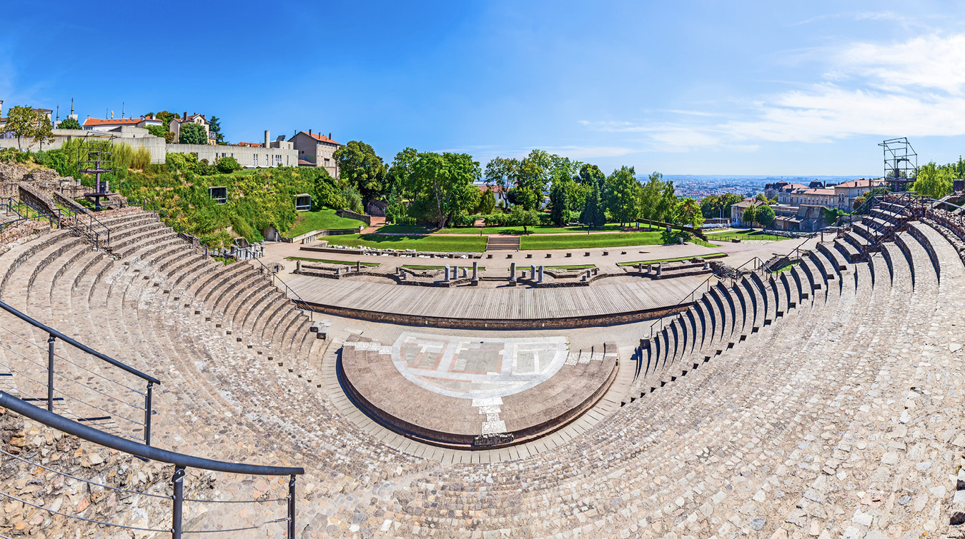
Figure 3.12. Roman amphitheater of the Three Gauls, Lyon. istock, 600371110
Earlier buildings occasionally were converted into Christian use. For example, at Cimiez (Roman Cemenelenum), a northern suburb of Nice (Alpes-Maritimes), a Christian basilica was built on part of the East Baths in the fourth century AD.
France also shows archaeological evidence of early monasticism. The monastic community at Ligugé, near Poitiers (Vienne), the present-day Abbaye Saint-Martin de Ligugé, was established by Martin of Tours around AD 360. It was founded on the site of a Roman villa, and excavation suggests that some of the villa’s rooms were adopted for use as a church. The fourth century AD church had a nave and apse eighteen meters long, to which a martyrium in the form of a cross was added in the early fifth century AD.
Maritime Trade: Shipwrecks from the Etruscan and Roman Periods
France has played a leading role in the development of underwater archaeology, discussed further in chapter 4. This section focuses on shipwrecks found off the southern coast of France from two discrete periods: the sixth and fifth centuries BC and first century BC to the first century AD. These shipwrecks provide invaluable evidence of trade in these periods.
The shipwrecks from the sixth and fifth centuries BC date from the period following the establishment of the Greek colony of Massalia. Two shipwrecks from this period are discussed in detail, the Cap d’Antibes and the Grand Ribaud F wrecks.
The wreck off Cap d’Antibes (Alpes-Maritimes) was excavated between 1955 and 1969 and found to have been partly looted by sport divers. The main cargo of the ship, which was wrecked in the middle of the sixth century BC, was at least 180 Etruscan amphorae. It also included Greek amphorae together with more than sixty examples of the characteristic Etruscan pottery known as bucchero and a few vessels decorated in the Etrusco-Corinthian style.
Slightly later in date is the shipwreck discovered in 1999 west of the island of Grand Ribaud, one of the Hyères Islands (Var), at a depth of around sixty meters. The particular wreck designated Grand Ribaud F was excavated in 2000 and 2001. The cargo suggests that the ship was wrecked at the end of the sixth century BC or beginning of the fifth century BC. Much of the hull of the ship, which was around twenty-five meters long, was preserved thanks to protection by its cargo of amphorae. Up to one thousand Etruscan amphorae from Cerveteri in modern-day central Italy, some of which carried inscriptions, were discovered together with fine-ware and coarse-ware ceramics and small bronze dishes.
Other shipwrecks from this period have been found off the coast of southern France, most notably Bon Porte, near Saint-Tropez (Var); Pointe Lequin, on the north side of Porquerolle island (Var); and Dattier, west of Cap Cavalaire (Var). The Bon Porte I wreck, found in 1971, was a small vessel carrying Etruscan and Greek amphorae. The Pointe Lequin IA wreck carried a much larger cargo, predominantly amphorae from diverse areas of the Mediterranean together with a large number of Greek fine wares. The small wreck found off the coast at Dattier in 1971 had already been looted, although fifteen amphorae were noted. Sadly, the majority of these were looted during the course of excavation before they could be raised to the surface.
Many Roman shipwrecks have been found off the southern coast of France. This section concentrates on the important wreck at Madrague de Giens (Var), with some discussion of wrecks found close to the lighthouse at La Chrétienne, near Saint-Raphaël (Var); and at Port Vendres (Pyrénées-Orientales), close to the border between modern-day France and Spain.
The Madrague de Giens wreck was discovered in 1967 by French naval divers in the harbor at Madrague de Giens, on the northwest tip of the Giens peninsula, lying at a depth of between nineteen and twenty-two meters. The ship came to rest on the seabed leaning to one side, covered by sediment, which aided the excellent preservation of the upper part of the ship’s hull. The excavation by a team led by André Tchernia began in 1972 and continued for eleven seasons. The ship was found to have been wrecked in the first century BC, between about 75 and 60 BC, while exporting wine from central Italy, probably destined for Massalia and the cities of southern Gaul.
The Madrague de Giens wreck was fully excavated. It was a large ship, forty meters long, and is estimated to have carried between fifty-eight hundred and seventy-eight hundred amphorae, stacked up to three or four levels, making it one of the larger Roman merchant vessels. The amphorae and silt covering helped preserve some of the hull, with the major timbers made from oak and the lesser timbers from pine or elm. The presence of large ballast stones, foreign to the area, seemingly were used as diving aids by salvage divers in the Roman period. The salvage divers appeared to have cleared valuable commodities, including many amphorae, meaning that large parts of the cargo had been raised in antiquity. It is not known how common salvage would have been in the past, but it is clear that the loss of a valuable cargo would have been considered catastrophic. The ship that sank at Madrague de Giens was clearly large, undoubtedly with a correspondingly rich cargo, and its owners may have ordered salvage.
The majority of the amphorae found on the Madrague de Giens wreck were of the Dressel 1B type, elongated in form. Many carry the stamps of Publius Veveius Papus, an estate owner, from Terracina, south of Rome. Few such seals survive on land sites, as the seals would have been broken to release the wine. The placement of the amphorae in the hold of the ship can be reconstructed. Analysis of the sediments in the amphorae indicates that the wine from the Madrague de Giens shipwreck was a red wine. The cargo also included defrutum, made from boiling down must, the freshly pressed grape juice. A secondary cargo was pottery, mainly black slipware produced both in Campania and other parts of Italy, which was widely exported. It also included some amphorae from East Greece, modern-day Turkey. Rather than being part of the cargo to be sold, this type of amphora probably either contained stores for the crew or were older amphorae carrying water or other produce.
More than one hundred other Roman shipwrecks are found along the coast of southern France. Although some sank before the second century BC, the majority sank in the second and first centuries BC, decreasing in number after the reign of Augustus (first century AD and later). The majority of the second and first century BC ships found wrecked off the coast of modern-day France sailed from ports on the Italian peninsula, carrying locally produced goods.
One of these shipwrecks is designated the Chrétienne C, discovered close to the lighthouse of La Chrétienne and investigated by Jean-Pierre Joncheray in the early 1970s. The ship, which sank between 175 BC and 150 BC, represents the early stage of the wine trade between Italy and France. The ship, which was only fifteen meters long, carried about five hundred Greco-Italian amphorae, possibly the produce from a single estate. Shipboard materials included tools and three sounding weights.
The shipwreck designated Port Vendres II was found off the Mediterranean coast, close to the border between France and Spain, and excavations took place between1974 and 1984. The wreck, which can be dated to the mid-first century AD, carried a cargo primarily consisting of amphorae carrying Spanish olive oil, wine, and salted fish. The cargo also included ingots of copper, lead, and tin, some of the latter marked with inscriptions giving dates between AD 41 and AD 48. Some of the other objects found on the ship, including spoons, a strigil, a comb, lamps, and a ceramic inkwell, may have belonged to the crew. The Port Vendres II wreck is particularly useful for its insight into trade from the area of modern-day Spain in the Early Roman Imperial period.
The rivers of France were used extensively to transport goods in the Roman period. Good evidence of this came to light in 2004 with the discovery by Luc Long and his team of the remains of a barge in the river Rhône at Arles (Bouches-du-Rhône), known as Arles Rhône 3. The barge dated to the first century AD, the time of the monumentalization of Roman Arelate. It was a trading vessel, thirty-one meters long, carrying a cargo of building stone quarried some fifteen kilometers north of Arles. The archaeologists, who excavated the barge between 2008 and 2010, also found the vessel’s galley, identified by the presence of cooking utensils. The oak timbers of the hull were well preserved, and the decision was taken to cut the vessel into ten sections and raise it in 2011. The barge has been on display in the Musée de l’Arles et de la Provence antiques since 2013.
A similar vessel was found during excavations that took place in 1989 and 1990 in the Place Tolozan in Lyon, close to the river Rhône. The barge, which dates between AD 30 and AD 40, was excavated in advance of the installation of an underground cable. It was lifted in three parts and conserved between 1990 and 2003 at l’Atelier Régional de Conservation Nucléart (ARC-Nucléart) in Grenoble (Isère). The barge was found to be 7 meters long and 2.4 meters wide and had apparently been abandoned. It is now in the collection of the Musée Gallo-Romain du Lyon-Fourvière.
The group of six Gallo-Roman ships discovered in the river Saône at Lyon is discussed further in chapter 6.
Early Medieval France
Although Roman Gaul did not formally come to an end until AD 486 with the victory of the Franks at the Battle of Soissons, it had been preceded by a period of decline. The fifth century AD in Western Europe was characterized by the movement of non-Gallic people into Gaul. Vandals, Alans, and Suevi entered Gaul from Germania, crossing into modern-day Spain in AD 407. From the south, following their sack of Rome in AD 410, the Visigoths entered Gaul in AD 412. The Visigoths subsequently invaded modern-day Spain in AD 415, but in AD 418 they withdrew back into Gaul and established a capital at Tolosa, modern-day Toulouse (Haute-Garonne). Other groups of non-Gallic people were the Burgundians, who settled in the areas around the rivers Saône and Rhône; and the Alamanni, who moved into Alsace. The Franks settled in northern France, in the modern-day Ile-de-France region.
There is little archaeological evidence for the presence of any Visigoths in southwest Gaul in the fifth century AD. An exception is the series of carved stone sarcophagi often given the names “Visigothic,” “Aquitanian,” or “southwest Gallic,” found in the area known as Septimania, which was regarded as part of Gaul in the fifth century AD. The borders of Septimania were defined by the Massif Central to the north, the Pyrenees to the west and south, and the Camargue marshes to the east. The “Visigothic sarcophagi” were usually made from marble quarried in the commune of Saint-Béat (Haute-Garonne). Carved in very low relief, the earlier sarcophagi are fairly plain, with typical decoration being apostles under a row of arches, whereas the later type are more ornate and feature vine decoration. The main centers of production were Narbonne (Aude) and Béziers (Hérault), although sarcophagi have also been found in Toulouse (Haute-Garonne), Agen (Lot-et-Garonne), and Bordeaux (Gironde). It seems clear that Narbonne-based artisans specialized in sarcophagi with ivy-branch decoration, made from local marble quarried at the nearby commune of Saint-Pons-de-Thomières (Hérault), as opposed to the Saint-Béat marble used elsewhere. Five examples of this type of sarcophagus are in the Musée Lapidaire at Narbonne.
Another characteristic object were the “Aquitanian buckles,” large bronze buckles with a tinned surface, decorated with incised geometric and animal motifs. A particular type of buckle had a beak-like projection, and the distribution of finds suggests they may have been worn by locally recruited troops who defended Toulouse and the Garonne valley from attacks from the Visigoths of Septimania. The distribution of Visigothic objects in southern Gaul suggests that production of rectangular cloisonné belt buckles was divided between modern-day Spain and Septimania. Simpler buckles and radiate-headed brooches may well have been made locally. The buckles are found along the coast from Perpignan (Pyrénées-Orientales) to Montpellier (Hérault), with others around Carcassonne (Aude) and Albi (Tarn). Finds from excavations at the commune of Giroussens (Tarn) suggest that it was probably a Visigothic cemetery, a rare Visigothic site found in Frankish territory. Few Visigothic objects are found elsewhere in Aquitaine, two fine exceptions being a fibula in the shape of an eagle, decorated in the cloisonné technique, said to be from the commune of Valence d’Agen (Tarn-et-Garonne); and a buckle with an eagle-headed terminal from the fourth-century AD Gallo-Roman “Villa de Nymfius” in the commune of Valentine (Haute-Garonne). Visigothic coins, minted with the names of their kings, have been found in Septimania and southern Gascony but nowhere else in Gaul apart from occasional examples in hoards.
The characteristic pottery from southern Gaul made between AD 350 and AD 600 were gray and orange stamped wares. It has been classified into three main groups distinguished by the fabric and decoration: Languedoc, Provencal, and Atlantic, the latter probably based in Bordeaux (Gironde). The pottery has been useful in determining trade patterns during this period. Languedoc wares were barely exported, in contrast to the Provencal pottery, exported to the east coast of Spain, Italy, and the eastern Mediterranean, including Athens. The Atlantic pottery was exported to the English Channel ports, Wales, and Switzerland. The inward-looking aspect of Septimania also is suggested by the lack of evidence of use between the fifth and eighth centuries AD of the once-flourishing Roman road known as the Via Aquitania, which linked Narbonne (Aude), Toulouse (Haute-Garonne), and Bordeaux (Gironde).
The Rise of the Franks
Clovis, who was leader of the Franks from AD 480 to AD 511, became the dominant ruler in what had been Gaul and the first king of the Merovingian dynasty. The Frankish kingdom expanded; the Burgundians and Alemanni were conquered by Clovis, and the Visigoths withdrew from Aquitania into modern-day Spain. Even though the Franks gave their name to the modern-day country of France, their kingdom extended beyond present-day boundaries into what is now Belgium, the Netherlands, and northern Germany. Although some architectural remains survive from this period, most of the archaeological evidence comes from tombs.
Interaction between the recently arrived Franks and the existing inhabitants is evident from excavations at the cemetery in the commune of Frénouville (Calvados), near the town of Caen. The cemetery began to be used for burials in the fourth century AD and was in continuous use until the seventh century AD. However, the orientation of the graves changed in the early fifth century AD, and it is apparent from excavation that those aligned north to south are Late Roman whereas those aligned east to west are Frankish.
Other evidence of the transition from the Late Roman to the Early Medieval period has been found elsewhere in Normandy at the commune of Mondeville (Calvados), where a Merovingian cemetery was excavated by Capitaine G. Caillaud between 1913 and 1917. Subsequent excavations at the cemetery at Mondeville revealed eighth-century AD wooden buildings in the form of “grave houses” over burials, either singly or in groups.
The few architectural remains from this era are overwhelmingly Christian, most notably the Baptistère Saint-Jean at Poitiers (Vienne) and Merovingian crypts at Jouarre (Seine-et-Marne) and Grenoble (Isère).
The Baptistère Saint-Jean, adjacent to the cathedral at Poitiers, is considered to be one of the most notable examples of Merovingian architecture. It was founded traditionally in AD 360 on the instructions of Saint-Hilaire, the first bishop of Poitiers, although the structure visible today is Merovingian and Carolingian in date. The initial archaeological research at the baptistery was undertaken by Etienne-Marie Siauve in 1803. Siauve was an interesting character; initially a priest, he later became a soldier, including serving as military commissioner from 1800 until his death during the retreat of the French Grande Armée from Russia in 1812. Siauve was also the author of several archaeological publications and a member of the Académie celtique, which became the Societé nationals des antiquaires de France. At the baptistery in Poitiers, Siauve discovered an octagonal basin below floor level alongside a channel that connected it to the disused Roman aqueduct. Damage to the baptistery undoubtedly led to the building’s acquisition by the French government in 1834, with extensive renovations between 1852 and 1859. Elsewhere in Poitiers, in 1878 preparations for the building of artillery defenses uncovered part of a Gallo-Roman cemetery. The site was excavated by Camille de la Croix, a Jesuit priest from Belgium. He reported that he had found an Early Medieval subterranean mausoleum, which has been given the name the Hypogée des Dunes. Unusually for the time, la Croix reburied the monument, which has been dated to the seventh century AD, until there was a way in the future to protect it, although he retrieved finds from the excavation. Restoration of the Hypogée des Dunes has begun, and visitors are able to visit the monument a few days each year.
The two crypts at Jouarre (Seine-et-Marne), the Crypt of Saint-Paul and the adjoining Crypt of Saint-Ebrégisile, are part of the Abbaye Notre Dame de Jouarre. In particular, the Crypt of Saint-Paul, which was built surrounding two colonnades of Gallo-Roman columns topped by capitals carved in the Merovingian style, is noted for a series of burials in sarcophagi, most notably of Agilbert. Agilbert, who died in AD 681, was the brother of Abbess Theodochilde, who founded the abbey around AD 630. The carvings on Agilbert’s sarcophagus show scenes of the Last Judgment and Christ in Majesty and are considered to be among the best surviving examples of pre-Romanesque sculpture in France.
Another stunning example of Merovingian architecture exists in Grenoble (Isère), where the Musée archéologique Grenoble-Saint-Laurent houses the crypt of Saint-Oyand. The site of the museum has a long history, incorporating the deconsecrated twelfth-century church of Saint-Laurent. This was built on a Carolingian church, itself built on a church associated with burials and crypt dating to the sixth century AD. It was in this latter period that the cult of Saint-Oyand, usually called “Eugendus” in English, was introduced following his death in AD 510. The sixth-century AD church was built on a cruciform plan, with the north and south arms forming the exterior of the twelfth-century AD church. The crypt under the east arm is preserved under the choir of the later church. The roof of the crypt is supported by a colonnade of twenty columns, of which sixteen are original. These are surmounted by richly carved capitals, typical of the pre-Romanesque era.
The crypt of Saint-Oyand was brought to scholarly attention in 1803 through an article by Jacques-Joseph Champollion-Figeac, the elder brother of the renowned Egyptologist Jean-François Champollion. The crypt also attracted the attention of Prosper Merimée, Inspecteur général des monuments historiques, who was alerted to damage to the building in 1846. The crypt was categorized as a historic monument in 1850, one of the earliest to be designated in France.
The most characteristic Merovingian archaeological remains are grave goods from elite burials excavated throughout France. Collections of these grave goods were formed mainly between 1870 and 1914.
A major collector was John Evans, who purchased Merovingian objects, most notably grave offerings found at Picquigny (Somme) dating to the sixth century AD. Rather than from a single burial, as originally believed, the “group” comprises a combination of objects associated with both male and female burials. On Evans’s death in 1908, much of his collection, including the objects from Picquigny, was presented to the Ashmolean Museum in Oxford, England, by his son, the noted archaeologist Arthur Evans. Finds from Picquigny include objects made from gold and silver gilt, decorated in the cloisonné technique with garnets and glass. These include radiate-headed bow brooches, earrings, and a finger ring. A particularly interesting object was a rock crystal amulet, thought to have been worn at the waist.
An early excavation of a Merovingian cemetery was the result of a chance find in 1886 by Philippe Delamain from the commune of Jarnac (Charente), a member of the local family famous for its production of cognac. The cemetery was found at Herpès, in the commune of Courbillac (Charente), and was excavated by Delamain between 1889 and 1893. Most of Delamain’s finds were bought by the collector Edouard Guilhou in 1901 and sold in 1905. Many of the objects were purchased by the British Museum in London; others, the Metropolitan Museum of Art in New York. The objects are typical of Merovingian production in the sixth century AD, and comprise brooches of different types, made from silver gilt and garnets, belt mounts, buckles, and weaponry. Bowls there were made of both glass and pottery. Delamain also excavated a Merovingian cemetery in the commune of Biron (Charente-Maritime).
A group of Merovingian tombs came to light in the early twentieth century while quarrying for chalk at Rosay, now part of the commune of Val-de-Vière (Marne). The grave goods, which date between AD 500 and AD 550, include six pieces of jewelry now in the Metropolitan Museum of Art in New York. They are all decorated in the cloisonné technique with garnets and glass, and comprise a pair of silver gilt radiate-headed bow brooches and a pair of gold earrings, both very similar to objects from Picquigny mentioned previously, together with a pair of silver gilt disc brooches.
The most lavish known Merovingian burial is of Queen Arégonde, who died in AD 580 or 581, excavated at the Basilica of Saint-Denis (Seine-Saint-Denis). The basilica was built on a Gallo-Roman cemetery, the reputed burial place of Saint Denis, who was martyred in about AD 250. The first king to be buried in the basilica was Dagobert in AD 639. However, the area below the present basilica was used as a necropolis for the Merovingian elite from the late fifth century AD, which led to the flourishing of this location. In addition, excavations below the present basilica suggest that many women in particular were buried there, seemingly a desire for their remains to be as close as possible to Saint Denis.
In 1959 a stone sarcophagus was found containing the burial of a woman, who was identified from a ring inscribed with her name as Queen Arégonde and giving her the title of queen (figure 3.13). The grave goods were appropriate for Arégonde, who was the daughter of a king (Clovis I), wife of a king (Clotaire I), and mother of another (Chilperic). Jewelry, in the collection of the Musée d’Archéologie nationale, included gold filigree earrings; a gold belt buckle with garnet and glass fittings; and pins, including a large and elaborate pin inlaid with garnets and glass. Arégonde’s clothing was unusually well preserved. It was made from very high-quality textiles, some of which had been imported from outside the Frankish kingdom. The cuffs of her long garment were made of samite, a heavy silk fabric incorporating thread of precious metal, which would have been imported from Persia. Her head and shoulders had been covered with a veil made from a similar fabric. Above Arégonde’s long garment, dyed with purple dye made from murex shells, and below her burial shroud was a lavish textile made from a mixture of very fine wool and beaver hair. Fragments of leather were found from Arégonde’s shoes, together with metal fragments, which have enabled the reconstruction of her shoes and leg bindings. This burial has been especially helpful to archaeologists in the reconstruction of the clothing of an elite Merovingian woman.

Figure 3.13. Sarcophagus of Queen Arégonde, Basilica of Saint-Denis. Alamy
The Abbaye-Saint-Victor in Marseille (Bouches-du-Rhône) includes a fifth-century AD crypt, notable for excavations of burials, particularly that of a woman that included well-preserved textiles and plant remains. The woman, who died in the late fifth century AD aged in her late twenties, was buried in a stone-built tomb. She was wrapped in linen wearing a decorated silk damask tunic and fringed cloak. The woman, whose head rested on a cushion of flowers, was buried with a gold cross on her forehead.
Important Merovingian discoveries continue to be made. A group of five rich burials, dating from the fifth to sixth centuries AD, was excavated in 1987 in the commune of Louvres (Val-d’Oise), close to Paris-Charles-de-Gaulle airport. The burials were found around the Tour Saint-Rieul, the remains of a twelfth-century AD church. Four of the burials were of females; the fifth, a man, was accompanied by his iron sword. All burials included grave goods of high-quality cloisonné jewelry; the women were buried with pendants, bracelets, buckles, and brooches of different shapes. In the case of the man, the scabbard of his sword was ornamented with cloisonné decoration.
France has provided a major contribution to the current understanding of ancient maritime trade in the western Mediterranean through exploration of shipwrecks found off its Mediterranean coast and along its major rivers. Likewise, discoveries from the Iron Age and the period of Roman occupation in France have shed light on the effects of Greek colonization and the conquest by Rome. The arrival of non-Gallic people into Late Roman and Early Medieval France, culminating in the establishment of the Merovingian dynasty of kings, is also a main feature of French archaeology in this period.