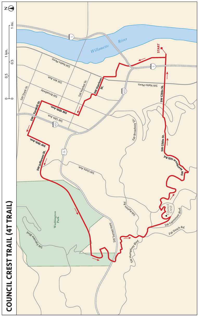
 Start at the South Waterfront Lower Tram Terminal, located on SW Moody Avenue next
to the Oregon Health and Sciences University building (OHSU).
Start at the South Waterfront Lower Tram Terminal, located on SW Moody Avenue next
to the Oregon Health and Sciences University building (OHSU).
THE RUN DOWN
START: South Waterfront Lower Tram Terminal; elevation 72 feet
OVERALL DISTANCE: 6.6 miles
APPROXIMATE RUNNING TIME: 2 hours (depending on transportation schedules)
DIFFICULTY: Blue
ELEVATION GAIN: 1,322 feet
BEST SEASON TO RUN: Year-round
DOG FRIENDLY: Leashed dogs permitted
PARKING: Free
OTHER USERS: None
CELL PHONE COVERAGE: Good
MORE INFORMATION: https://4ttrail.wordpress.com/
FINDING THE TRAILHEAD
Start at the South Waterfront Lower Tram Terminal, located on SW Moody Avenue next
to the Oregon Health and Sciences University building (OHSU).
RUN DESCRIPTION
This route has it all—“Trail, Tram, Trolley, Train���—resulting in the aptly named 4T Trail. From the start at the lower tram station, you will experience the trails in and out of the forest, public transportation, roads, stairs, and views of Mount Hood. The entire route is very well signed, with 4T trail markers pointing the way through the neighborhood and other sections. The route ends at the upper tram station. Tram rides down are free. Some options for sustenance along the way include the Daily Cafe at the Tram, 3355 SW Bond Avenue, and the Little Big Burger, 3704 SW Bond Avenue.
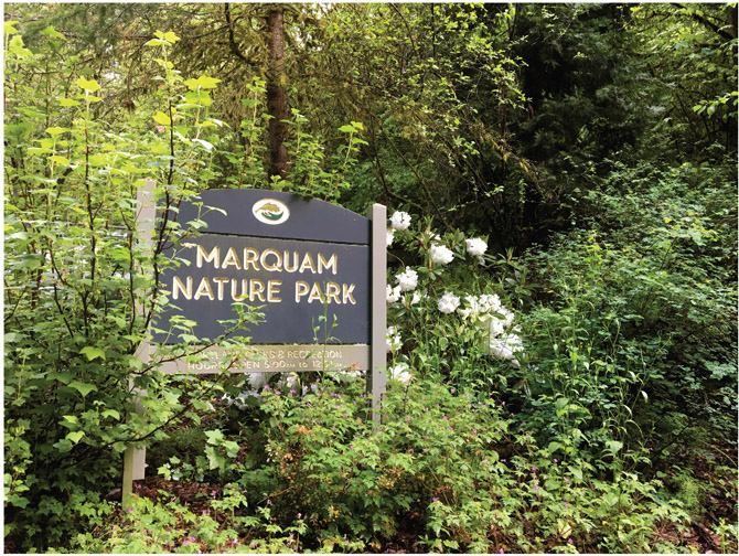
Located in Forest Park, 178-acre Marquam Nature Park is comprised primarily of singletrack trails within canopied forest. Be mindful of falling tree limbs on the trails in early spring. This is common in many forested areas in the Pacific Northwest, when the weight of water absorbed during the rainy season tends to put stress on branches and causes breakage. Trails are well marked. This is also the trail portion of the 4T Portland experience—Trail, Tram, Trolley, Train.
THE RUN DOWN
START: Marquam Park Shelter; elevation 316 feet
OVERALL DISTANCE: 3 miles out and back (on a parallel trail)
APPROXIMATE RUNNING TIME: 40 minutes
DIFFICULTY: Blue due to the elevation gain
ELEVATION GAIN: 761 feet
BEST SEASON TO RUN: Year-round
DOG FRIENDLY: Leashed pets permitted
PARKING: Free
OTHER USERS: Foot traffic. Can be crowded, and sightings of local running celebrities are common
CELL PHONE COVERAGE: Very good
MORE INFORMATION: www.fmnp.org
FINDING THE TRAILHEAD
Park in the lot at SW Marquam Street and Sam Jackson Park Road, located a short walk
from the trailhead (fifteen spots). You can also park at the nearby Duniway Track
and run about 1 mile for a warm-up to the trail.
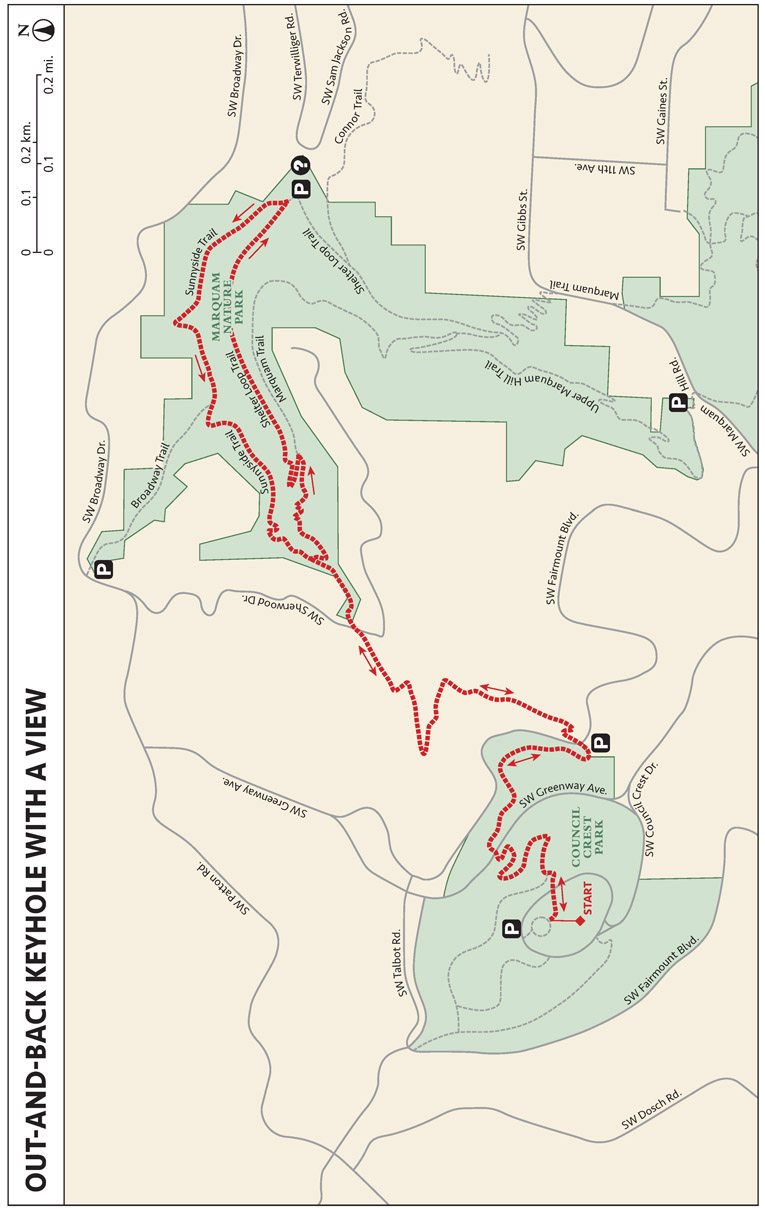
RUN DESCRIPTION
This out-and-back keyhole loop starts on a slight uphill paved section on the Marquam Shelter Trail and is primarily on singletrack trails, meandering in and out of the forest with some long, sweeping switchbacks. There are some steps on the route and two road crossings. There are also gradients over 20 percent in spots, making for some steep running. It is a well-marked trail and the view from the top at Council Crest will include Mount Hood on a clear day. Return down the way you came on the Marquam Trail to the Sunnyside Trail, or at the fork, take the Shelter Trail back to the start point.
THE RUN DOWN
START: Uphill from the parking lot on SW Marquam St.; elevation 988 feet
OVERALL DISTANCE: 4.5-mile loop
APPROXIMATE RUNNING TIME: 50 minutes
DIFFICULTY: Blue
ELEVATION GAIN: 988 feet
BEST SEASON TO RUN: Year-round although the singletrack can get a bit muddy in heavy rains
DOG FRIENDLY: Leashed dogs permitted
PARKING: Free
OTHER USERS: None
CELL PHONE COVERAGE: Good
MORE INFORMATION: www.fmnp.org
FINDING THE TRAILHEAD
Take SW Marquam Street off Sam Jackson Park Road. Approximately 100 yards down SW
Marquam Street, there is signage on the right-hand side for Marquam Nature Park. The
trailhead is located uphill from the parking lot.
RUN DESCRIPTION
There are three trail options from this location. Continue uphill on Marquam Street, which dead-ends to a gate. You can continue uphill on the Shelter Trail, which is located immediately beyond the bollards and provides a loop route experience. Additionally, there are two singletrack trails: One is the Sunnyside Trail, to the right, and the other is the other end of the Shelter Trail.
Following the run, enjoy some food and drink at spots such as the Stumptown Coffee Roasters, 1026 SW Stark Street; Deschutes Brewery Portland, 210 NW 11th Avenue; and Lair Hill Bistro, 2823 SW 1st Avenue.
THE RUN DOWN
START: Oregon Zoo; elevation 883 feet
OVERALL DISTANCE: 30 miles one way
APPROXIMATE RUNNING TIME: 5 to 12 hours
DIFFICULTY: Black for distance; blue for trails
ELEVATION GAIN: 3,530 feet
BEST SEASON TO RUN: Year-round
DOG FRIENDLY: Leashed dogs permitted
PARKING: Free
OTHER USERS: Mountain bikers and equestrians on designated trails
CELL PHONE COVERAGE: Good
MORE INFORMATION: www.forestparkconservancy.org
FINDING THE TRAILHEAD
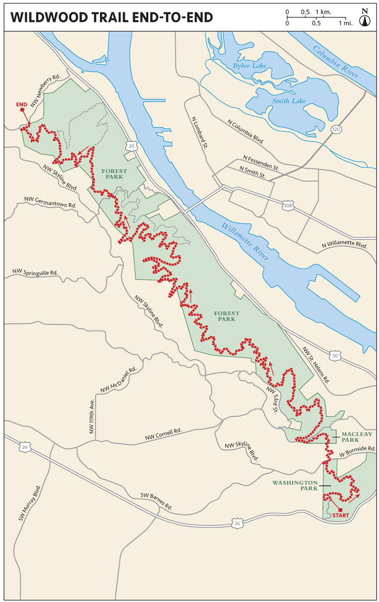
Start at the Oregon Zoo at mile zero and end at Newberry Road; or turn around at
any point for an out-and-back effort.
RUN DESCRIPTION
This well-maintained, buffed-out singletrack traverses terrain in the forest. There are three road crossings if the route is done in its entirety. The trail stretches across the largest urban forest in the United States, Portland’s 5,000-acre Forest Park.
Begin by looking at the wear and tear on your old, “spent” shoes. Are the soles worn in certain parts and not in others? Wear patterns provide evidence of overpronation or supination. By looking at wet footprints left after a shower, bath, or swim and comparing your prints with others, you can determine relative arch height and forefoot width. Armed with those particular “foot notes,” a trail runner is better able to shop for shoes at a local specialty running store, in a catalog, or from an online vendor, and better prepared to ask an expert salesperson for a recommendation. It is best to go to a running specialty store, where a foot specialist can perform a gait analysis using a videotaped treadmill or other test.
When shopping for trail shoes, wear the same kind of socks worn for running. Similarly, those who use orthotics should bring the devices to ensure shoes fit once the orthotic is inserted. Also, it is best to shop immediately or soon after a run, when your feet are most likely to be swollen. Ultrarunners should err on the side of buying a half to a whole size larger than normal to accommodate foot swelling.
Be wary of buying a new model or style of shoes from a catalog or website. Just because a trail runner has liked a brand of shoe does not mean the runner will be happy with another model or style from the same manufacturer. Similarly, just because a trail runner enjoys a particular shoe model does not guarantee that the next iteration with the same model name will fit or perform in a similar manner. Shoe manufacturers are always tweaking their lines in an effort to better the product, and all too often those “improvements” leave the runner with a shoe that goes by the same name but has an entirely different feel, fit, or performance. When in doubt, buy from a local retailer, especially if you can test-drive the shoes on a treadmill or in the parking lot.
THE RUN DOWN
START: Goose Hollow Inn; elevation 180 feet
OVERALL DISTANCE: 4.4 miles one way
APPROXIMATE RUNNING TIME: 70 minutes
DIFFICULTY: Blue
ELEVATION GAIN: 942 feet
BEST SEASON TO RUN: Year-round
DOG FRIENDLY: Leashed dogs permitted
PARKING: Free
OTHER USERS: Cyclists
CELL PHONE COVERAGE: Good
MORE INFORMATION: http://explorewashingtonpark.org
FINDING THE TRAILHEAD
Start at Goose Hollow Inn, located at 1927 SW Jefferson Street. Parking is available
at the trailhead. Head west along SW Jefferson Street under the historic Vista Avenue
Bridge.
RUN DESCRIPTION
This route is great for uphill intervals or a lung-busting uphill tempo run. Start on the entrance to Washington Park on SW Jefferson Street, and go up the paved Madison Trail in Washington Park, to the Mac Trail just beneath the International Test Rose Garden, and climb the Mac Trail all the way up to the Zoo/MAX Train stop, which is also the start of the Wildwood Trail. When heading uphill, cross several roadways on the winding trails. To avoid the downhill run, ride four minutes back down to the trailhead on the MAX train. Enjoy eats at Coffeehouse Northwest, 1951 W Burnside Street; dine at your starting point at Goose Hollow Inn, or at Laughing Planet Cafe, 1755 SW Jefferson Street.

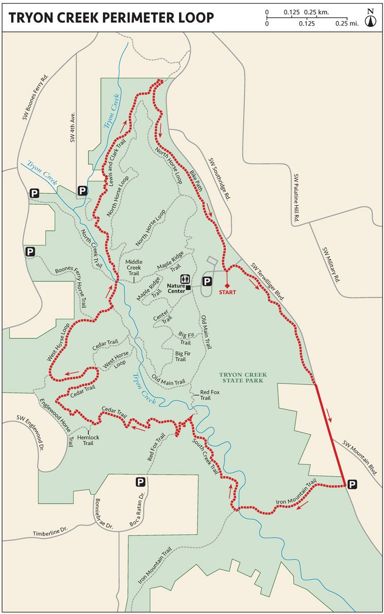
With 8 miles of trails over 658 acres, Tryon Creek State Natural Area is Oregon’s only state park within a major metropolitan area. The park is located off I-5 at Terwilliger Boulevard in Southwest Portland. The nearest bus routes are the #39 and #35. A mixture of singletrack and wide pathways crisscross the park. Carrying a map (a photo on your smartphone) would be beneficial to better navigate routes due to multiple trail connectors and intersections. It is better to look like a tourist than to be lost.
THE RUN DOWN
START: Near the visitor center; elevation 252 feet
OVERALL DISTANCE: 1.2-mile loop
APPROXIMATE RUNNING TIME: 15 minutes
DIFFICULTY: Green
ELEVATION GAIN: 166 feet
BEST SEASON TO RUN: During heavy rains this can be a bit muddy, but the trail has very good absorption due to hard-packed dirt
DOG FRIENDLY: Leashed dogs permitted
PARKING: Free
OTHER USERS: Equestrians on designated trails; mountain bikers on paved trails only
CELL PHONE COVERAGE: Very good
MORE INFORMATION: http://oregonstateparks.org/index.cfm?do=parkPage.dsp_parkPage&parkId=103
FINDING THE TRAILHEAD
Parking is located at 11321 SW Terwilliger Boulevard, and there is also on-street
parking with a short walk to the trails. Know that this is a very busy venue on the
weekends. The trailhead is near the visitor center, with signage indicating the various
trails accessed from this point.
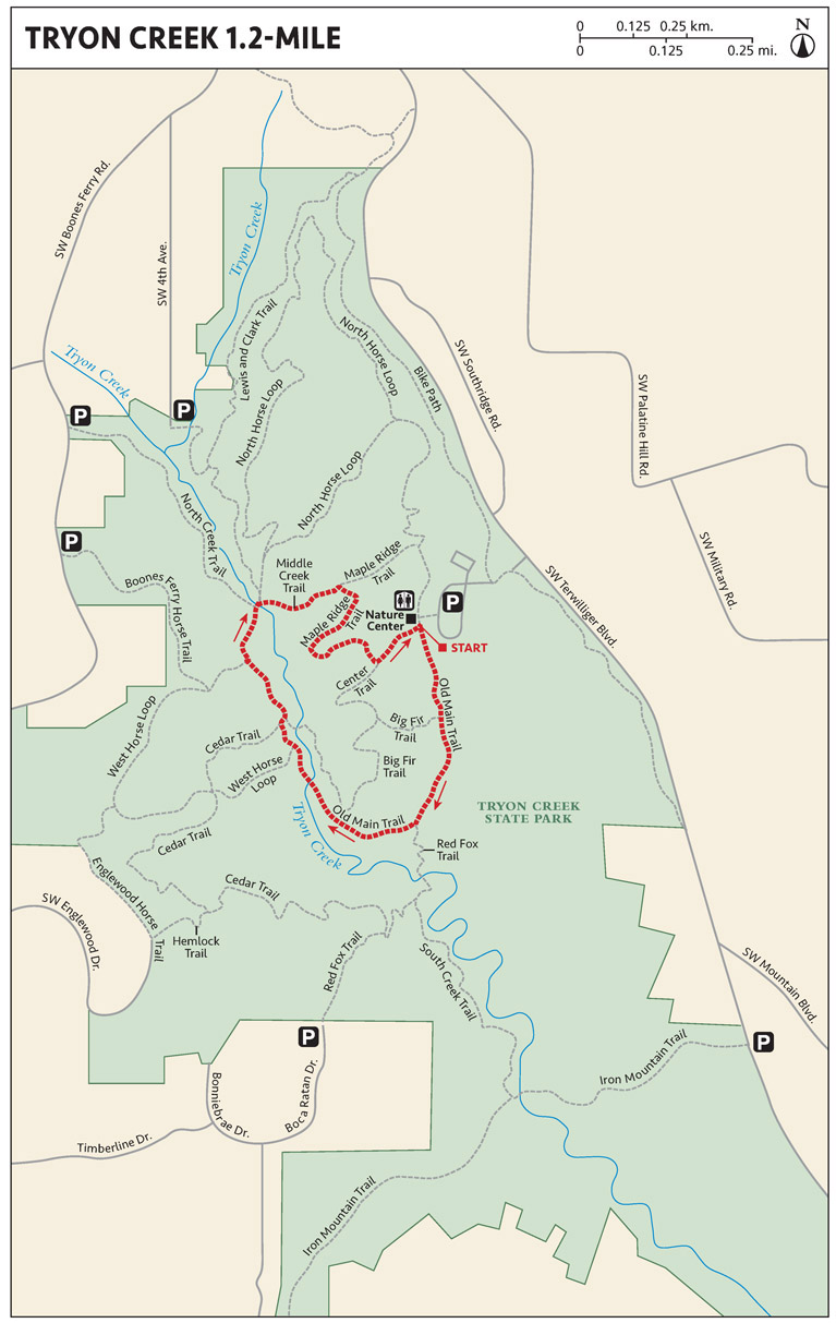
RUN DESCRIPTION
Head south on the Old Man Trail for a clockwise loop encompassing a very short section in the park. The loop takes in parts of the North Horse Loop and the Maple Ridge Trail. There are foot bridges to cross and forests to enjoy along the route. It is beneficial to carry a map, a screen shot of the map in this guide, or a map on your phone to navigate the various junctions on the trail system.
MAKE YOUR TRAIL SHOES LAST LONGER
The best way to prolong the life of trail shoes is to have several pairs and rotate them so that one pair is never used for more than a couple of consecutive runs without getting a rest. Using old beater pairs on days when the weather is particularly “sucky” also extends the life of newer shoes that you would rather not expose to brutal conditions. Like allowing the body to have recovery days, giving shoes some time off allows the midsole materials—the parts that usually break down the fastest—to decompress between runs.
It is a good idea to wash shoes by wiping them down to remove caked mud. Remove the insole inserts from the footbeds and insert balled-up newspaper in each footbed while the shoes dry at room temperature. If the shoes are soaked, it may be necessary to replace the newspaper once or twice.
It is best to allow shoes to dry slowly. That way they will be less likely to delaminate. Do not run the shoes through the washing machine or dryer or put them in the oven, as this can damage the midsole material. Reserve your favorite trail shoes for the activity they were made for: Do not wear them to work, for walking, or for hiking because that compresses and stresses them in ways that are not conducive to running—plus, such activities break them down prematurely.
THE RUN DOWN
START: Near the interpretive center; elevation 312 feet
OVERALL DISTANCE: 3.4-mile loop
APPROXIMATE RUNNING TIME: 40 minutes
DIFFICULTY: Green
ELEVATION GAIN: 397 feet
BEST SEASON TO RUN: During heavy rains this can be a bit muddy, but the trail has very good absorption due to hard-packed dirt
DOG FRIENDLY: Leashed dogs permitted
PARKING: Free
OTHER USERS: Equestrians on designated trails; mountain bikers on paved trails only
CELL PHONE COVERAGE: Good
MORE INFORMATION: http://oregonstateparks.org/index.cfm?do=parkPage.dsp_parkPage&parkId=103
FINDING THE TRAILHEAD
Proceed to the entrance off SW Terwilliger Boulevard, which is indicated by signage
stating TRYON CREEK STATE PARK NATURE STORE. Park in the lot just west of SW Terwilliger Boulevard. Proceed to the trailhead
sign age near the interpretive center. There are restrooms at the center, as well
as a drinking fountain.
RUN DESCRIPTION
This loop is run in a counterclockwise direction. You’ll enjoy smooth surfaces throughout the run, along with a smattering of exposed tree roots and rocks on the trails. The trails are well maintained and not technical. There is a very informative sign at the Nature Center with a great map. Take a photo when you start to plan your route. All creek crossings have footbridges.
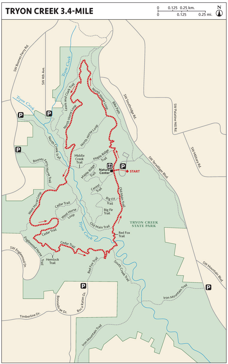
Starting on the North Horse Loop, connect to the West Horse Loop after approximately 1.3 miles. Follow West Horse Loop less than 1 mile to the intersection with the Cedar Trail. At just under 3 miles, connect to the Old Man Trail, which heads back to the starting point.
THE RUN DOWN
START: Near the interpretive center; elevation 331 feet
OVERALL DISTANCE: 4.5-mile loop
APPROXIMATE RUNNING TIME: 50 minutes
DIFFICULTY: Blue
ELEVATION GAIN: 459 feet
BEST SEASON TO RUN: During heavy rains this can be a bit muddy, but the trail has very good absorption due to hard-packed dirt
DOG FRIENDLY: Leashed dogs permitted
PARKING: Free
OTHER USERS: Equestrians on designated trails; mountain bikers on paved trails only
CELL PHONE COVERAGE: Good
MORE INFORMATION: http://oregonstateparks.org/index.cfm?do=parkPage.dsp_parkPage&parkId=103
FINDING THE TRAILHEAD
Proceed to the entrance off SW Terwilliger Boulevard, which is indicated by signage
stating TRYON CREEK STATE PARK NATURE STORE. Park in the lot just west of SW Terwilliger Boulevard. Proceed to the trailhead
sign age near the interpretive center. There are restrooms at the center, as well
as a drinking fountain.
RUN DESCRIPTION
Start on the Terwilliger Trail, heading south approximately 0.8 mile to the Iron Mountain Trail. Run east on this section for approximately 0.5 mile to the South Creek Trail, which becomes the Cedar Trail after crossing over the Red Fox Trail. After 2.4 miles, reach the junction with the West Horse Loop Trail and continue to the Lewis and Clark Trail at approximately 3 miles. At just under 4 miles, turn south on the Terwilliger Trail back to the starting point.

THE RUN DOWN
START: Near the dog park in Tualatin Community Park; elevation 112 feet
OVERALL DISTANCE: 5.8 miles in two loops
APPROXIMATE RUNNING TIME: 70 minutes
DIFFICULTY: Green
ELEVATION GAIN: 328 feet
BEST SEASON TO RUN: Year-round
DOG FRIENDLY: Leashed dogs permitted
PARKING: Free
OTHER USERS: Cyclists
CELL PHONE COVERAGE: Good
MORE INFORMATION: www.oregonhikers.org/field_guide/Cook_and_Durham_City_Parks_Hike
FINDING THE TRAILHEAD
Start at the Tualatin Community Park, 8515 SW Tualatin Road, in Tualatin. This park
has ball fields, tennis courts, a dog park, and several parking areas. The trail is
on the north side of the parking lot near the dog park. Walk north past the skate
park, baseball diamond, and basketball court to start your run near the dog park.
RUN DESCRIPTION
This route is flat as a pancake. It’s great for beginners or for those wanting to do a short and fast tempo run or pickups. Run along the Tualatin River and Fanno Creek, through wetlands, and through three city parks on a mixture of paved paths and trails, enjoying a wild paradise in the middle of suburbia. The main Fanno Creek Trail and the Tualatin River Trail are named and marked, but many smaller feeder trails are not.
From the SW Tualatin Road entrance, run east, toward the river, circumnavigating the park in the counterclockwise direction. Follow the Tualatin River Greenway path to the north, along the riverbank, crossing over railroad tracks and then over a bridge that joins the Fanno Creek Greenway, which parallels the tracks.

After almost 2 miles, keep to your right and complete a short loop as part of a lollipop, and then head back (south) along the same route for a quarter mile until you come to Wetlands at Durham Wastewater Trail . . . because, you know, everyone wants to run a trail with the word “wastewater” in the name. Follow the Durham Wastewater Trail to the Tualatin River Trail for an out-and-back to the end of the park, where it runs into SW 108th Avenue.
On the return, take the northern route of Tualatin River Trail, rejoin the Durham Wastewater Trail, and then head south, taking a right at the juncture with Fanno Creek Greenway. Keep on the Tonquin Trail, paralleling the train tracks, to your second left, where you follow the Tonquin Trail west and then south again to cross the tracks where you did on the outbound route. Return to Tualatin Community Park, finishing where you began.
Be sure to stop for eats at Doughnut Land, 19350 SW Boones Ferry Road, or for more substantial eats at C I Bar & Grill, 18786 SW Boones Ferry Road, or New Seasons Market, Nyberg Rivers Shopping Center, 7703 SW Nyberg Street.
Trail runners are often well-rounded athletes who enjoy a fine collection of outdoor endurance activities. With the changing seasons, trail runners are likely to supplement their recreational routines with Alpine and Nordic skiing; snowshoeing; kayaking; swimming; pool running; climbing; hiking; walking; martial arts; dance; horseback riding; skating; mountain, road, and stationary biking; and other pursuits. Engaging in other sports helps balance a trail runner’s training regimen, develop supporting muscles, and condition the cardio system, and throws an element of excitement and vivaciousness into the mix. Because running is not necessarily a full-body sport, integrating other activities into training helps strengthen the trunk and upper body, which might otherwise grow weak from neglect.
Skills and strengths gained from cross-training easily translate to trail running. The limbering and strengthening of muscles that comes from rock climbing, the lung capacity gained from Nordic skiing, high altitude training from mountaineering, descending skills from mountain biking, the leg strength gained from snowshoeing, the muscular balance gained from swimming—all of these make for a better trail runner.
Cross-training also gives some perspective to trail running. Cross-training can be used as “active rest”; you can feel good about not running while pursuing another discipline or developing new skills that enhance the trail-running dimension. By becoming passionate about other athletic endeavors, a trail runner is more likely to take adequate time away from running when a recovery period is necessary to recuperate from an overuse injury or to avoid overuse. Knowing there are alternatives to running trails certainly helps during a time of injury, boredom, or burnout from running.
Cross-training is easily integrated into the trail-running routine by substituting a different discipline for a running session or two each week. These cross-training sessions should be of equivalent intensity as the running would have been, as measured by heart rate, effort, and time. For example, after a long trail run on Sunday, replace the normal 45-minute Monday recovery run with a 45-minute swim, bike, or Nordic ski session of equivalent effort.
Depending on your trail-running goals, cross-training should complement and supplement running, but not supplant it. Although cross-training is an excellent way to maintain fitness while giving running muscles some time off, cross-training should be thought of as active rest, in that it should not be so strenuous or depleting that you are too exhausted to pursue trail-running training. Exercise some caution when trying a new sport, because it is easy to strain muscles that are not trained for that specific activity. It is rather disappointing to spoil your trail-running training effort because of an injury resulting from a cross-training mishap.