NORTHWEST PORTLAND
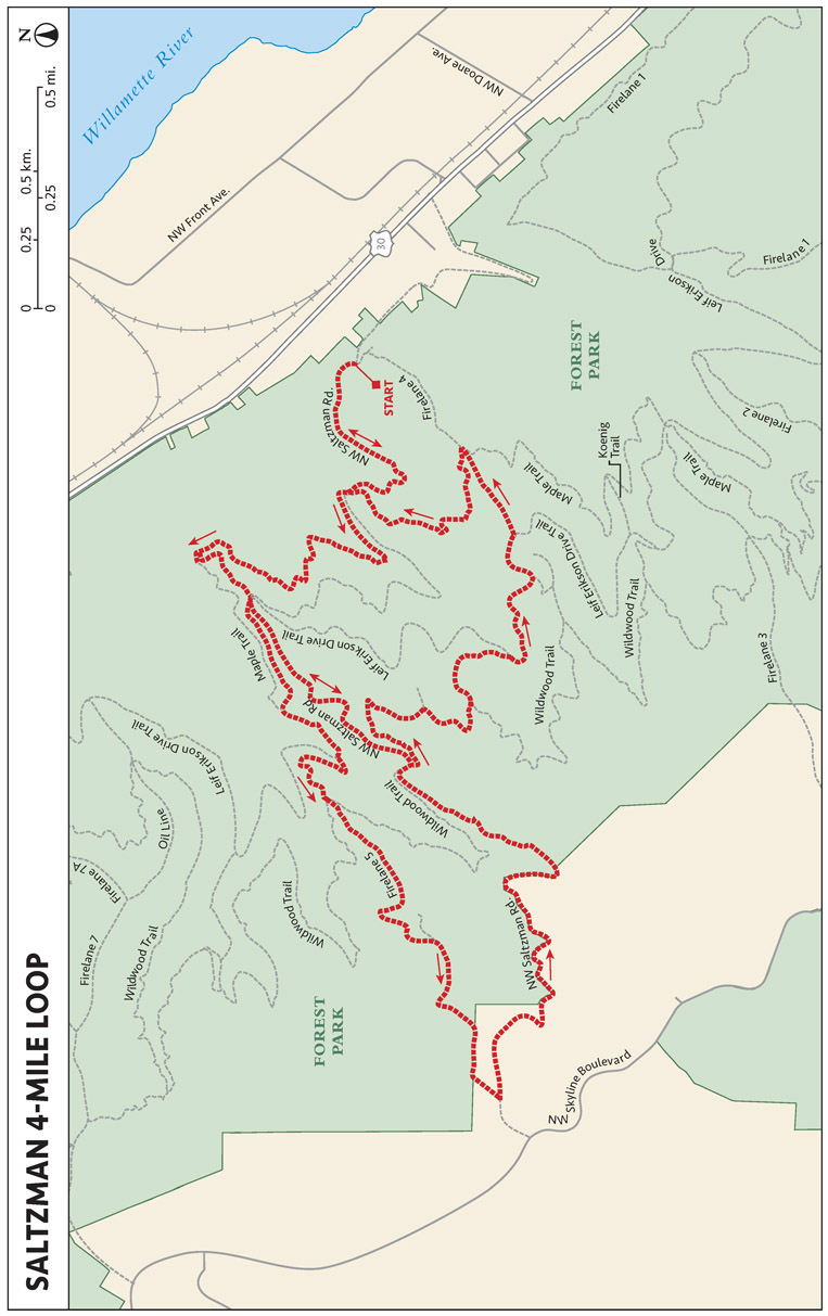
SALTZMAN 4-MILE LOOP
THE RUN DOWN
START: End of NW Saltzman Rd.; elevation 394 feet
OVERALL DISTANCE: 3.9-mile loop
APPROXIMATE RUNNING TIME: 45 minutes
DIFFICULTY: Blue
ELEVATION GAIN: 719 feet
BEST SEASON TO RUN: Year-round
DOG FRIENDLY: Leashed dogs permitted
PARKING: Free
OTHER USERS: Cyclists
CELL PHONE COVERAGE: Good
MORE INFORMATION: www.forestparkconservancy.org
FINDING THE TRAILHEAD
 If taking public transportation, take the #16 bus toward Sauvie Island and get off
at the NW St. Helens and Saltzman stop. Run up NW Saltzman Road to the trailhead.
You can also drive northwest out of Portland on NW St. Helens Road. Make a left on
NW Saltzman Road. NW Saltzman Road ends at the gate at the trailhead, where it becomes
a dirt and soft pine needle-strewn road.
If taking public transportation, take the #16 bus toward Sauvie Island and get off
at the NW St. Helens and Saltzman stop. Run up NW Saltzman Road to the trailhead.
You can also drive northwest out of Portland on NW St. Helens Road. Make a left on
NW Saltzman Road. NW Saltzman Road ends at the gate at the trailhead, where it becomes
a dirt and soft pine needle-strewn road.
RUN DESCRIPTION
This keyhole loop starts at the Lower Saltzman Gate. Proceed uphill on Saltzman Road
(dirt). Go right on Maple Trail, then left on Quarry Trail to the Saltzman/Leif Erikson
Drive junction. Continue straight (uphill) to Saltzman Road. Go left on Wildwood Trail;
left on Cleater Trail; right on Leif Erikson Drive; left on Firelane 4; left on Maple
Trail; and right on Saltzman Road, heading downhill to the gate. The first third is
uphill, the middle third is flat, and the final third is downhill, providing a nice
mix of elevation changes. The route is entirely in the forest and is a mix of singletrack
and fire road. There are no views.
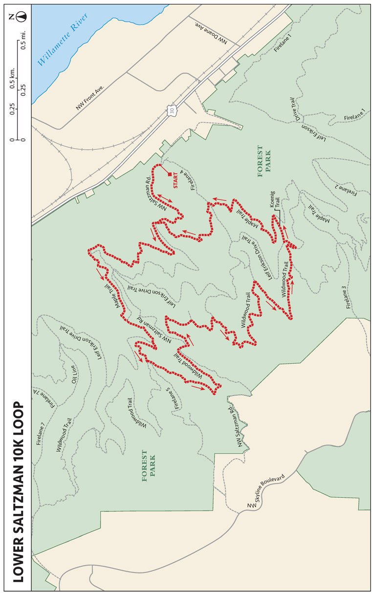
LOWER SALTZMAN 10K LOOP
THE RUN DOWN
START: End of NW Saltzman Rd.; elevation 400 feet
OVERALL DISTANCE: 6.2-mile loop
APPROXIMATE RUNNING TIME: 1 hour
DIFFICULTY: Blue
ELEVATION GAIN: 883 feet
BEST SEASON TO RUN: Year-round
DOG FRIENDLY: Leashed dogs permitted
PARKING: Free
OTHER USERS: Cyclists
CELL PHONE COVERAGE: Good
MORE INFORMATION: www.forestparkconservancy.org
FINDING THE TRAILHEAD
If taking public transportation, take the #16 bus toward Sauvie Island and get off
at the NW St. Helens and Saltzman stop. Run up NW Saltzman Road to the trailhead.
You can also drive northwest out of Portland on NW St. Helens Road. Make a left on
NW Saltzman Road. NW Saltzman Road ends at the gate at the trailhead, where it becomes
a dirt and soft pine needle-strewn road.
RUN DESCRIPTION
This is a longer variation of the Saltzman 4-Mile Loop.
This keyhole loop starts at the Lower Saltzman Gate. Proceed uphill on Saltzman Road
(dirt). Go right on Maple Trail and follow it to NW Firelane 5 Road, which switchbacks
to Wildwood Trail, taking the leftmost of the three trails at the juncture. Stay on
Wildwood, crossing NW Saltzman Road and then Cleater Trail, ignoring Firelane 4 on
your left, until you come to Koenig Trail. Take Koenig Trail to the left, which leads
over NW Leif Erikson Drive to a T with Maple Trail, where you head left (north) to
complete the loop back to Saltzman Road and the start/finish point.
TERRAIN AND TOPOGRAPHY
The terrain of the areas we’ve covered in this guide are quite varied. That’s one
of the many beauties of the Portland metropolitan area and its different trail-running
options: There are flat runs along waterfronts and mountain runs, and you can mix
them to spice things up if you’d like. We’ve included quite a few of each, so you
may select the perfect run to match your mood, or one with specific features if you
are training for a specific event.
Portland area trails tend to be forested and prone to mud, although many have been
rerouted to keep you from getting too wet or muddy. With some of the seasonal changes,
Portland trail runners need to be adept at running on mud, runoff, rock, and occasional
snow and ice. They must know how to confront water crossings and when to avoid dangerous
ones. Similarly, they must be capable of maneuvering around roots, rocks, fallen branches;
dealing with other trail obstacles; and handling wildlife confrontations.
Some of the trails in this guidebook are groomed and wide enough that they are practically
dirt roads, while others are of the singletrack variety. Some allow dogs, others do
not. Some turn into shoe-sucking mud when wet, others become rocky riverbeds. Still
others attract local fauna during mating or nesting season. We request that you honor
not only the notes about those trail sensitivities that we’ve provided in the guide,
but also that you be very aware of the conditions and follow Leave No Trace practices
in your trail running.
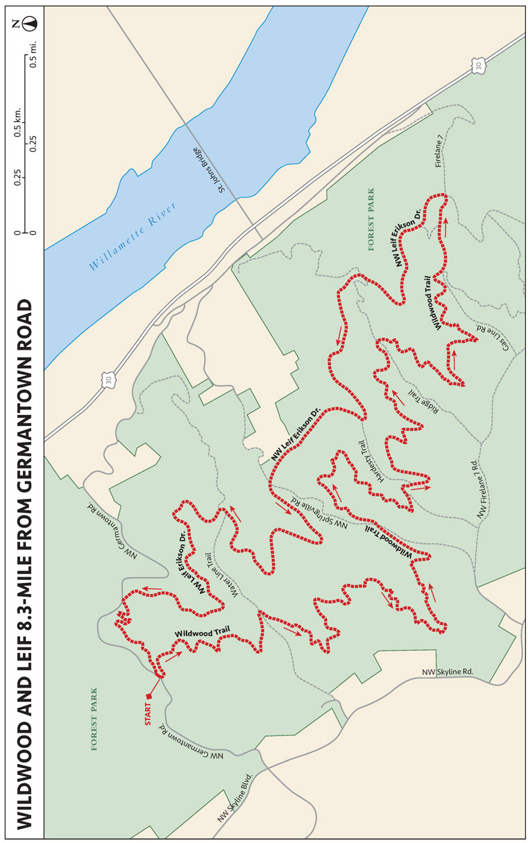
WILDWOOD AND LEIF 8.3-MILE FROM GERMANTOWN ROAD
THE RUN DOWN
START: Elevation 873 feet
OVERALL DISTANCE: 8.3-mile loop
APPROXIMATE RUNNING TIME: 1 hour, 20 minutes
DIFFICULTY: Blue
ELEVATION GAIN: 997 feet
BEST SEASON TO RUN: Year-round
DOG FRIENDLY: Leashed dogs permitted
PARKING: Free
OTHER USERS: Cyclists and equestrians on designated trails
CELL PHONE COVERAGE: Good
MORE INFORMATION: www.forestparkconservancy.org
FINDING THE TRAILHEAD
From US 30, take NW Germantown Road north, through a couple tight turns, before finding
parking on your left. The trailhead is readily accessible from the parking turnout.
RUN DESCRIPTION
This route follows a combination of buffed-out singletrack and good-quality dirt roads
with a lot of pine-needle covering. You’ll run through a heavily forested area, like
most of Forest Park.
From the parking lot, run downhill on the Cannon Trail. Turn right on the butter-smooth,
dirt NW Leif Erikson Drive. Turn right and run steeply uphill on the Gasline Trail.
Turn right on the Wildwood Trail and follow it all the way back to the parking lot.
FLORA AND FAUNA
Weapons to ward off the unlikely possibility of animal encounters are an unnecessary
encumbrance on Portland trails, unless you are in the remotest areas. High user traffic
tends to cause animals—mostly coyotes—to take refuge. The only annoying plants are
poison oak and the occasional stinging nettle. Human interactions are probably the
greatest cause for concern when running Portland-area trails, and we recommend running
with a companion if the area is likely to be dangerous.
All trail junctions in Forest Park are clearly marked. NW Leif Erikson Drive even
has white concrete posts with quarter-mile markers!
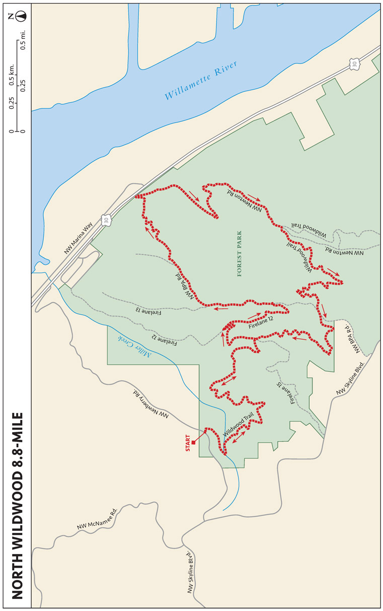
NORTH WILDWOOD 8.8-MILE
THE RUN DOWN
START: Wildwood trailhead; elevation 732 feet
OVERALL DISTANCE: 8.8-mile keyhole
APPROXIMATE RUNNING TIME: 90 minutes
DIFFICULTY: Blue
ELEVATION GAIN: 1,821 feet
BEST SEASON TO RUN: Year-round
DOG FRIENDLY: Leashed dogs permitted
PARKING: Free
OTHER USERS: Cyclists and equestrians on designated trails
CELL PHONE COVERAGE: Good
MORE INFORMATION: www.forestparkconservancy.org
FINDING THE TRAILHEAD
Head northwest from downtown Portland. Take NW St. Helens Road to Newberry Road,
and follow Newberry Road to the Wildwood trailhead.
RUN DESCRIPTION
This part of Forest Park is bisected by a large power line. The clear-cut under the
lines provides views to the north of the Willamette and Columbia Rivers, and to Mount
Saint Helens and Mount Rainier. Some of the ascending is quite steep, as it heads
directly uphill without switchbacks. The route is primarily on singletrack, with sections
of primitive doubletrack (overgrown pathway). This is the least trafficked part of
the Wildwood Trail; being farther from the city, this section provides a more primitive
feel, with overgrown trees and vegetation that can wildly grow very close to the trail
in the summer.
From the parking area, take the Wildwood Trail. Turn left on Firelane 15, right on
Firelane 12, then left on the BPA Road. Follow the BPA Road downhill, under the power
lines, until you almost reach the heavily trafficked NW Saint Helens Road. Turn right
on the dirt NW Newton Road, which will take you back uphill to where you rejoin the
Wildwood Trail. Turn right on the Wildwood Trail and run all the way back to the parking
area.
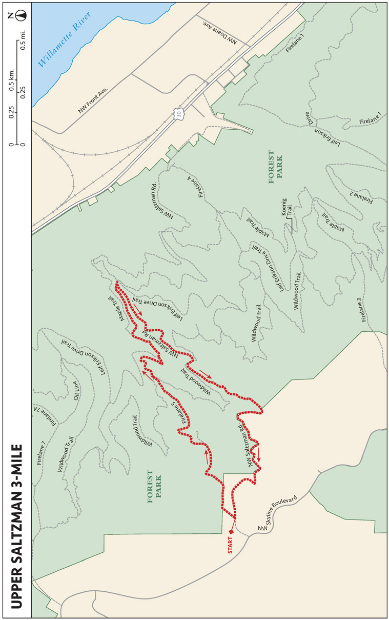
UPPER SALTZMAN 3-MILE
THE RUN DOWN
START: At the gate on NW Saltzman Rd.; elevation 1,125 feet
OVERALL DISTANCE: 3.0-mile loop
APPROXIMATE RUNNING TIME: 35 minutes
DIFFICULTY: Blue
ELEVATION GAIN: 459 feet
BEST SEASON TO RUN: Year-round
DOG FRIENDLY: Leashed dogs permitted
PARKING: Free
OTHER USERS: Cyclists and equestrians on designated trails
CELL PHONE COVERAGE: Good
MORE INFORMATION: www.forestparkconservancy.org
FINDING THE TRAILHEAD
Take NW Skyline Boulevard northwest from downtown Portland, and take a right on NW
Saltzman Road. The parking lot is right at the gate. As the route name suggests, this
follows the upper part of Saltzman Road.
RUN DESCRIPTION
This run is mostly downhill to start and uphill to finish. Although this is a short
run, the climbing and descending make it a bit more challenging. About 40 percent
of the route is on singletrack and 60 percent on dirt road.
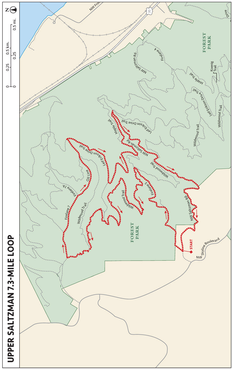
UPPER SALTZMAN 7.3-MILE
THE RUN DOWN
START: At the gate on NW Saltzman Rd.; elevation 1,096 feet
OVERALL DISTANCE: 7.3-mile loop
APPROXIMATE RUNNING TIME: 75 minutes
DIFFICULTY: Blue
ELEVATION GAIN: 1,161 feet
BEST SEASON TO RUN: Year-round
DOG FRIENDLY: Leashed dogs permitted
PARKING: Free
OTHER USERS: Cyclists and equestrians on designated trails
CELL PHONE COVERAGE: Good
MORE INFORMATION: www.forestparkconservancy.org
FINDING THE TRAILHEAD
Take NW Skyline Boulevard northwest from downtown Portland and take a right on NW
Saltzman Road. The parking lot is right at the gate; no restrooms, services, or water
are available. As the name suggests, this is the upper part of Saltzman Road.
RUN DESCRIPTION
This route is similar to the Upper Saltzman 3-Mile, but is a bit longer. One of the
least busy trailheads into Forest Park, Upper Saltzman is a great starting point for
runners who want an easy (i.e., all downhill) start to their runs. Heavily forested,
the trails leading from Upper Saltzman are cool and shaded on hot summer days.
Run downhill on Firelane 5; turn left on the Wildwood Trail; turn right on Firelane
7; and continue straight on the NW Oil Line Road until it meets NW Leif Erikson Drive.
Turn right on NW Leif Erickson Drive; turn right on NW Saltzman Road, and run uphill
to the parking area.
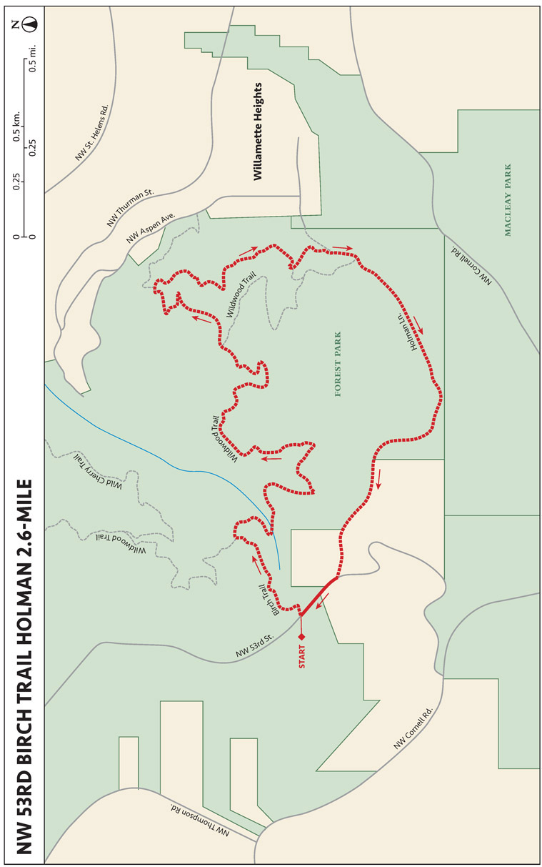
NW 53RD BIRCH TRAIL HOLMAN 2.6-MILE
THE RUN DOWN
START: Trailhead on NW 53rd Dr.; elevation 840 feet
OVERALL DISTANCE: 2.6-mile loop
APPROXIMATE RUNNING TIME: 40 minutes
DIFFICULTY: Blue
ELEVATION GAIN: 551 feet
BEST SEASON TO RUN: Year-round
DOG FRIENDLY: Leashed dogs permitted
PARKING: Free
OTHER USERS: Cyclists
CELL PHONE COVERAGE: Good
MORE INFORMATION: www.forestparkconservancy.org
FINDING THE TRAILHEAD
Take NW Cornell Road out of downtown Portland. Turn right on NW 53rd Drive to reach
the trailhead.
RUN DESCRIPTION
This is a short loop ideal for hill climb workouts up Holman. Begin with a short drop
onto Birch Trail, then take your first right onto Wildwood Trail, which will curve
clockwise until you reach Holman Lane at about one o’clock. Follow Holman back up
to your starting point to complete the loop.
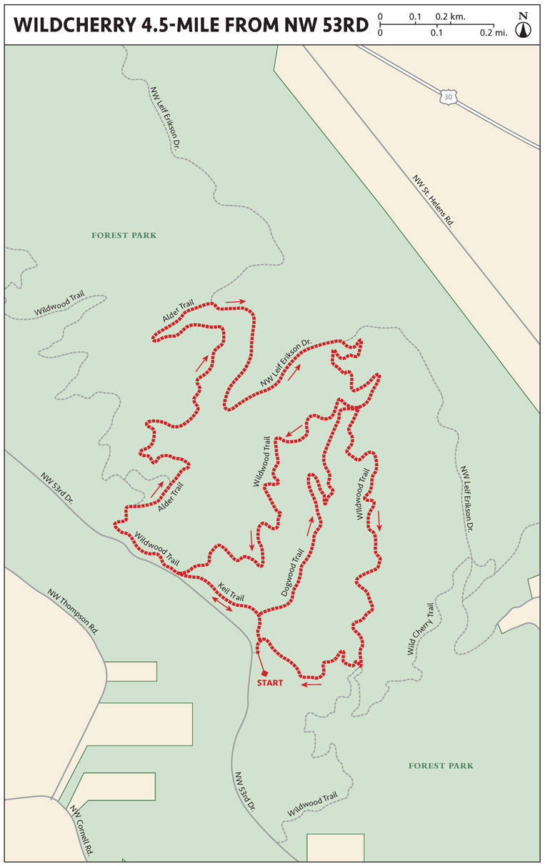
WILDWOOD ALDER DOGWOOD TRAILS 4.5-MILE
THE RUN DOWN
START: Wild Cherry Trail/Dogwood trailhead; elevation 909 feet
OVERALL DISTANCE: 4.5 miles round trip
APPROXIMATE RUNNING TIME: 45 minutes
DIFFICULTY: Green
ELEVATION GAIN: 468 feet
BEST SEASON TO RUN: Year-round
DOG FRIENDLY: Leashed dogs permitted
PARKING: Free
OTHER USERS: Mountain bikers and equestrians on designated trails
CELL PHONE COVERAGE: Good
MORE INFORMATION: www.portlandoregon.gov/parks/finder/index.cfm?action=ViewPark&PropertyID=127
FINDING THE TRAILHEAD
Take NW Cornell Road out of downtown Portland. Turn right on NW 53rd Drive and follow
NW 53rd Drive to the Wild Cherry Trail/Dogwood Trail trailhead signs.
RUN DESCRIPTION
Start near the high point and run down, up, down, up, all on singletrack. You can
easily add more distance by continuing on Wildwood Trail or Leif Erikson Drive. All
of the signage in Forest Park is consistent throughout, with all junctions marked
by green signs with white lettering. There are mile markers on the Leif Erikson and
Wildwood Trails. (In fact, each quarter-mile is marked on Leif Erikson with white
concrete posts with black lettering.)
Start on the Dogwood Trail and run uphill. Turn left on the Keil Trail; turn left
on the Wildwood Trail; turn right on the Alder Trail. Turn right on NW Leif Erickson
Drive; turn right on the Dogwood Trail; turn left on the Wildwood Trail; then turn
right on the Wild Cherry Trail. Turn right on the Dogwood Trail; turn left on the
Wildwood Trail; turn left on the Keil Trail; and then turn right on the Dogwood Trail
to run back to the parking area.
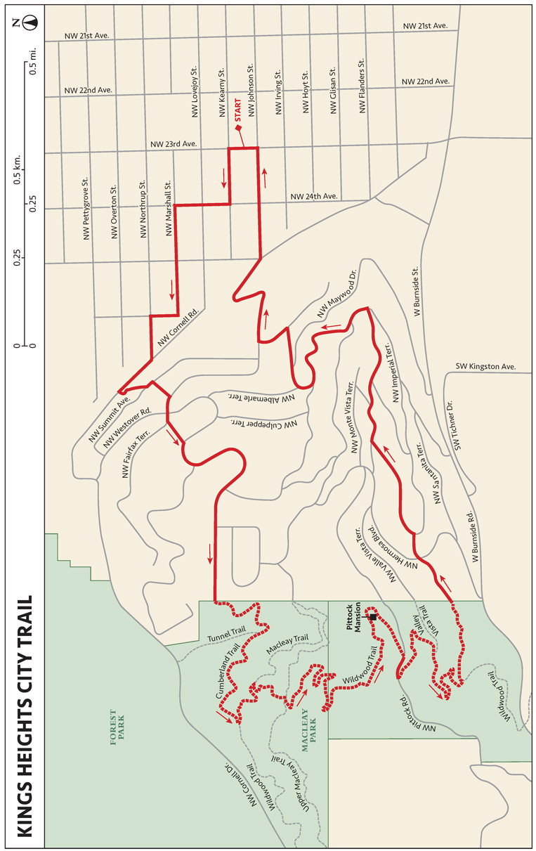
KINGS HEIGHTS CITY TRAIL
THE RUN DOWN
START: Barista Coffee shop; elevation 151 feet
OVERALL DISTANCE: 4.5-mile loop
APPROXIMATE RUNNING TIME: 60 minutes
DIFFICULTY: Blue
ELEVATION GAIN: 889 feet
BEST SEASON TO RUN: Year-round
DOG FRIENDLY: Leashed dogs permitted
PARKING: Free
OTHER USERS: Hikers, cyclists, and cars on road sections; no bikes allowed on trails
CELL PHONE COVERAGE: Good
MORE INFORMATION: http://pittockmansion.org
FINDING THE TRAILHEAD
Start from the Barista Coffee Shop at 823 NW 23rd Ave. in Northwest Portland.
RUN DESCRIPTION
Run stairs and trails to the historic Pittock Mansion. The route through the neighborhood
(Kings Heights) is paved. All of the trails within Macleay Park are dirt and singletrack
in heavily forested terrain. The footing is easy, but there is a lot of vertical.
There are three staircases to ascend along the route. Overall the route is 60 percent
road and 40 percent trail.
From the finish at Pittock Mansion, you can enjoy magnificent views—in fact, the best
in the city—on a clear day. Mount Rainier and Mount Saint Helens are to the north,
downtown Portland and Mount Hood are to the east. This area has one of the highest
densities of restaurants, coffee shops, breweries, bars, and boutiques in the city.
People venture here from all over the region to enjoy these amenities.
From Barista Coffee Shop, go west on NW Kearney Street, then right on NW 24th Avenue.
Go left on NW Marshall Street, then left on NW 26th Avenue, and then up the staircase
at the end of NW 26th. Go right on NW Cornell Road, left on NW Summit Court, and then
left on NW Summit Avenue. Look for steep staircase on the right, go up the stairs,
and then go right on NW Westover Road.
Go straight at the four-way intersection and continue on NW Fairfax Terrace. Look
for the stairs to the left just after the junction, and ascend the stairs to take
a right on NW Cumberland Road. NW Cumberland Road ends where Cumberland Trail begins.
Follow Cumberland Trail, turning left on Wildwood Trail. Follow Wildwood Trail to
Pittock Mansion at the summit.
To return, continue on Wildwood Trail toward the Oregon Zoo. Turn left on Verde Vista
(a dirt road that becomes paved). Turn right on NW Beuhla Vista Terrace; left on NW
Macleay Boulevard; right on NW Albemarle Terrace; right on NW Melinda Avenue; right
on NW Westover Road; left on NW Johnson Street, and finally, left on NW 23rd Avenue.
WATER CROSSINGS
Do you recall running through large puddles—or even small ponds—as a child? If so,
then perhaps you mastered the technique of taking exaggerated steps with a cartoonlike
form that kept you relatively dry while making everyone near you wet. That skill is
invaluable, and if you don’t have it down, take advantage of the dampness that Portland
offers and hone it. Go to a shallow stream, puddle, or other body of water that is
not more than 6 inches deep. Think of lizards that nature programs always show running
in slow motion across water. Try to duplicate that high-stepping form, and throw a
little lateral kick at the end of each stride to push the water away.
For deeper water crossings, decide whether it is worth trying to stay dry. The water
and air temperature, the width of the body of water, the rate of the current or flow,
the availability of an alternative crossing, and the amount of time you can afford
should factor into your decision. Also remember that going around water crossings,
puddles, or wet areas causes erosion.
If you don’t want to take the time to keep your feet dry or to change socks, consider
the “easy in/easy out” alternative. Wearing highly breathable footwear or trail-running
shoes with mesh uppers allows water to penetrate the shoe when confronting water crossings
but also allows water to exit quickly. Water will be effectively squeegeed out of
the shoe by running on dry terrain, and after a mile or two the recent drenching will
be only a faint memory. Wearing wool socks, especially ones made with merino wool
that does not itch, will maintain a moderate temperature for your feet regardless
of whether they are wet or dry. They will also help prevent blisters because of their
temperature-regulating attributes.