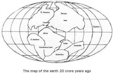
A few decades earlier, nobody believed in the Continental Drift Theory. Now geophysicists accept the fact. They believe that many centuries ago, the entire world was one place. It was united. But several geographical factors separated the continents. And they cannot answer that for how many more centuries, the world will remain in its present condition.
Will the earth keep on shifting slowly, or suddenly something drastic will happen? The scientists and scholars only speculate the situation.
Sometimes we read incredible piece of news in the newspapers. Scientists declare that settlements around sea are seeping inside the sea or at times we read that mountain ranges such as the Himalayas, the Andes and the Pamir are shifting from their place. However, scientists claim that it is happening so gradually that the process will take millions of years. The important point is whether the parts of earth are moving or not?
The process of ‘earth moving is called the Continental Drift Theory. A microscopic look at the world map reveals that various islands which presently have a zig-zag outline must have been a big circle. During earlier times, scientists used to think like this but they were not able to prove their thought scientifically. It was in 1915 that German meteorologist Alfred Wegener, produced a coherent picture of how the pre-historic earth might have looked with all its landmasses joined. At that time, he was ridiculed. But today Wegener is considered to be the father of Continental Drift Theory. He is regarded so great in his theory that some have suggested naming a crater on the moon after him. It was as late as in 1960 that geologists found some evidence to support Wegener’s hypothesis. Today, they have many evidences. They have based their result of modern topographic and core-sampling techniques. Out of these techniques, the geophysicists have been able to draw out a more dynamic picture of the earth’s crust.

Some years ago, scientists proclaimed that Australia, South Asia, Africa and south America must have been joined together. They derived this conclusion after conducting an extensive research in Antarctic. This declaration created an uproar in the world. Two American scientists – Dr. Robert and Dr. John too challenge and to test the authenticity of the declaration, they started doing experiments. The various points on which they carried out research were the speed at which an island foats, the direction where it shifts, its boundary line, the present position of the island, the expansion of oceanic rock sand, the earlier direction of ocean bodies.
After researching on the above lines, Dr. Robert and Dr. John arrived at the conclusion that 22,50,000 years ago all the continents must have been joined together. This meant that there must have existed only one ocean. And this ocean was called ‘Payjiya’. During those ancient times, South America and Africa were very close to each other and the boundaries of eastern America touched northern Africa. India was between South Africa and Antarctic.
Australia was part of Antarctic. According to them, the entire world was situated between 60 degree and 120 degree longitude.
However, this situation could not stay for long. After 50 lakh years of such an existence, the earth started dividing. At first, it was just divided into two parts – Laurashia in north and Gondwana land in south. In Laurashia, North America and Asia were included and Gondwana Land had South America, Africa, India, Australia and Antarctic.
The shifting continued and the earth came into its present shape nearly 6 crore 50 lakh years ago.
According to the geophysicists, the continents and large islands are believed to ride on top of plate-like slabs of lower crust. These plate like slabs, collectively called lithosphere, foat in turn on a semi molten sea of crystal slush called lithosphere, foat in turn on a semi molten sea of crystal slush called the asthenosphere. As a result, when molten rock from the asthenosphere boils into a crack separating two plates, it forces the pates and the continent apart. Dr. John and dr. Robert also believed in this theory.
Dr. Dave and Dr. Bird aggravated the above theory. They claimed that when two continents – India and Asia collided, a crater was formed into the land. Both the continents slide down and their sides slide down into the crust. And below the crust when they again collided, they came up vigorously and powerfully. So powerful was their thrust upwards that they took the form of a mountain. And this mountain is called Himalays. It was difficult to refute Dave and Bird. For this is one of the reasons accepted for the formation of mountains.
Mt. Andes in South America was formed in a different way. Ocean crust moved under the crust of the continent and the earth buckled up high, which came to be known as Andes mountains. Scientists believe that such changes in the earth crust must have happened simultaneously.
Geophysicists have finally agreed to the theory that all continents are slowly moving sideways. What will happen next to the earth? Nobody can answer this question. One can only hope that nothing traumatic happens by which the entire mankind may vanish.
