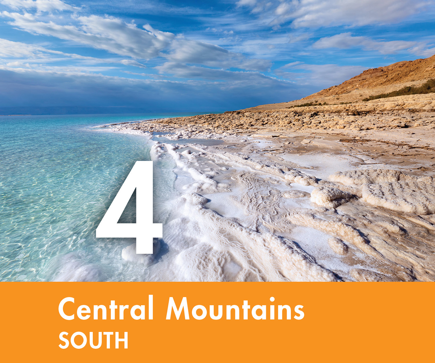
4. Central Mountains South
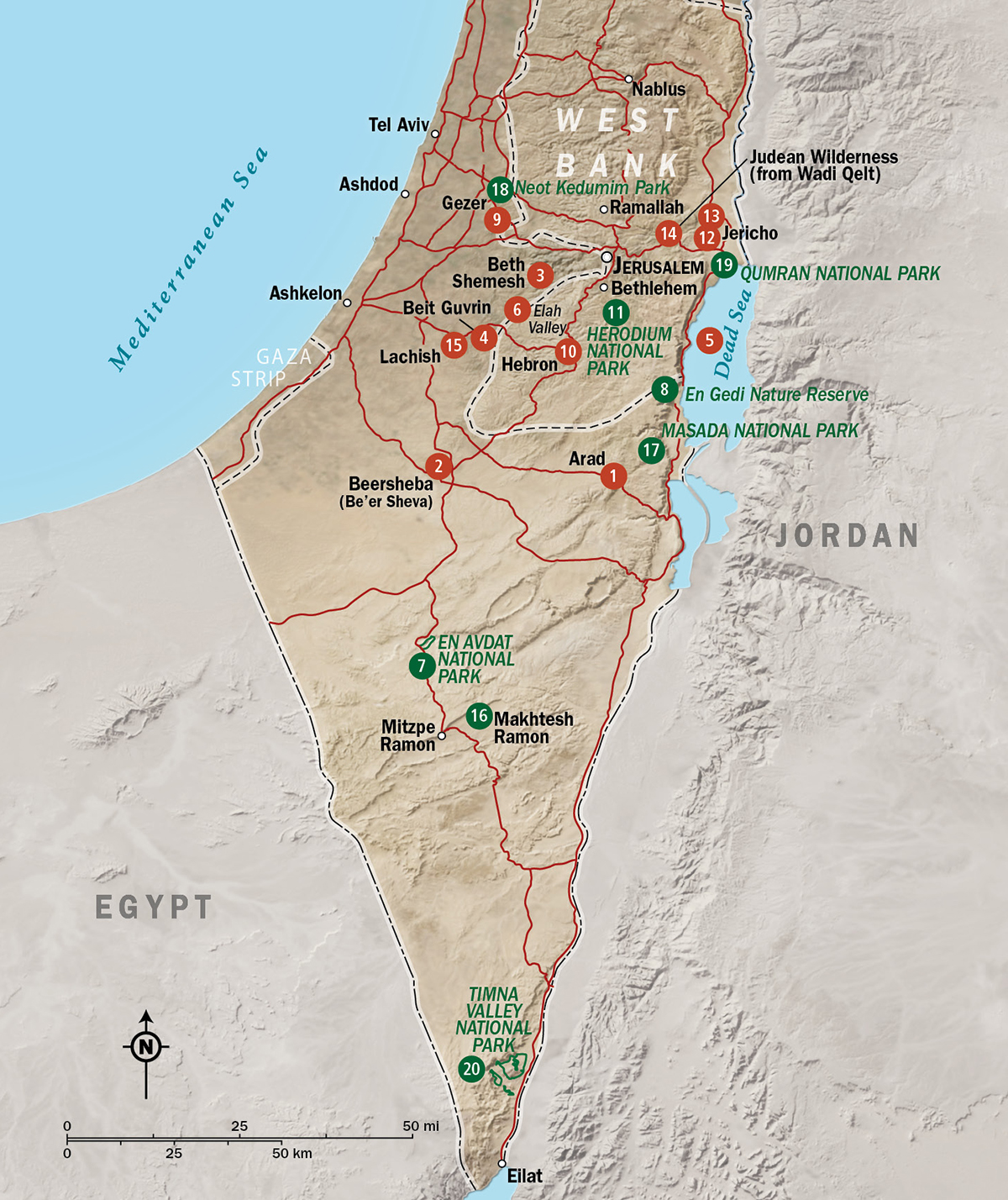
1 Arad
2 Beersheba
3 Beth Shemesh
4 Beit Guvrin National Park
5 Dead Sea
6 Elah Valley (from Tel Azekah)
7 En Avdat National Park
8 En Gedi Nature Reserve
9 Gezer
10 Hebron (Al-Khalil)
11 Herodium (Herodion) National Park
12 Jericho of the New Testament (Tulul Abu El-Alaiq)
13 Jericho of the Old Testament (Tell es-Sultan)
14 Judean Wilderness (from Wadi Qelt)
15 Lachish
16 Makhtesh Ramon
17 Masada National Park
18 Neot Kedumim Park
19 Qumran National Park
20 Timna Valley National Park
As you travel east from the coastal plain of Israel, you will find the geography changing quickly. The gently rolling plains give way to foothills that quickly give way to the central mountains. This is a zone of some variety with changes in elevation, topography, and rainfall. But overall, you will be struck by its higher elevations and the more sharply cut profile of the rising terrain. It is these realities that made ancient travel more difficult, invasion less of a concern, and farming a real challenge for those who lived here in Bible times.
I trust that your itinerary will include numerous days in the central mountains, because it hosted more Bible history than all of the other regions combined. That is why I have broken up this zone among three chapters in this guide. This particular chapter is dedicated to the southern part of the zone and its subregions: the fertile western foothills known as the Shephelah, the dry ridges and basins of the Negev, and the even drier and more rugged Judean Wilderness.
Arad
Tel Arad National Park is located in the driest of the three Negev basins. These basins mark the southernmost reach of the promised land in Bible times. The park provides a look into how people lived in this subregion both before the time of Abraham and during the time of the kings of Judah. Its archaeology includes a unique treasure. Within the fortress at the top of the hill, Judean soldiers constructed a worship facility that duplicated many of the elements of the temple in Jerusalem. There is nothing like it in the rest of Israel.
The park consists of two areas to explore. The older is the twenty-five-acre Early Bronze city that thrived between 2850 and 2650 BC. This sprawling city went out of existence about 450 years prior to the time of Abraham, making it a good place to see that a sophisticated society was part of this land long before it became the Israelite homeland. Those first residents settled here because Arad sat at a geographical crossroads. Roads radiated from here northeast into the Dead Sea basin, north into the highlands of Judah, and southwest to Egypt. These roads carried bitumen (a tar-like substance used in the embalming process) from the Dead Sea to Egypt and Egyptian goods destined for markets in Canaan.
Four elements of this Early Bronze city stand out. First, look for the surviving segments of the eight-foot wall and tower system that defended ancient Arad. It shows just how expansive this city was. As you marvel at its size, remember that this formidable city thrived centuries before the time of Abraham. Within the wall line you will find a large pagan worship complex with its altar and libation pit (a small stone-lined hole into which liquid offerings were poured). This is infrastructure of the Canaanite worship that repeatedly challenged Israel throughout the Old Testament.
Next, walk to the reconstructed Arad House. This single-room building demonstrates the construction style common to this era, one that is distinguished from the later style of home built by the Israelites. At the lowest point of the city you will find the cistern dug to harvest and hold millions of gallons of runoff water from the slopes that tilt toward its opening. When the Israelites built the fortress on the hill above, they dug the hole deeper. They struck the water table and the cistern became a well. From this spot they carried the water uphill and filled the cistern (underground water reservoir) located within the defensive walls of the fortress. This Israelite fortress on the high ground came into being long after the Early Bronze city of Arad ceased to exist. It was an outpost that went through several design changes from 1000 to 587 BC, from the time of David until the Babylonians invaded the promised land. Despite the design changes, it always functioned in the same way. Soldiers used it to watch for the advance of Edomite soldiers who were intent on attacking Judah from the south.
The signature element of this archaeological park is the Arad sanctuary within the fort. Israelite soldiers modeled this sanctuary on the temple in Jerusalem, a place unlike the pagan temple in the Early Bronze city below. Standing in the forecourt is an altar of uncut stones (Exod. 20:25). Beyond this altar is a courtyard with incense altars, like the holy place of the temple in Jerusalem. Those incense altars stand before a small room (like the holy of holies) that contained either one or two upright stones (perhaps meant to recall two stone tablets on which Moses received the Ten Commandments). All of these parallels have produced many questions to which there are no certain answers. Was this a symbolic or functioning temple? Did it mingle pagan elements with orthodox Jewish worship? While the answers to such questions evade us, one thing is certain: this Israelite sanctuary is unique, the sole surviving Old Testament Israelite sanctuary contemporary with the first temple in Jerusalem.
Finally, from the walls of the Israelite fortress it is possible to get a sense for the Negev ecosystem in which Abraham’s family lived upon entering the promised land (Gen. 12:9). The light-colored loess (windblown) soil of this area is rich in quartz. When the meager rainfall comes, the quartz crystals link to create a surface that sheds the life-giving moisture. Most years the grain planted here will not sustain until harvest. However, enough moisture is absorbed by the soil during the winter months to produce a flourish of spring grass favoring pastoralists like Abraham’s family. As these natural pastures yield their vitality before the hot southern winds of summer, pastoralists of the Negev move their sheep and goats north in incremental steps ever deeper into the heart of Canaan where pastures linger longer. It is no wonder the Bible often describes the family of Abraham on the move, building a relationship with the promised land not with deeds but with wells, seasonal camps, and altars they built along the migration routes that led north into the land they were given on oath.
INFORMATION  travel west from the modern city of Arad along Highway 80; the entry is about eight kilometers to its west;
Beersheba 
Tel Beersheba National Park presents the most complete reconstruction of an Old Testament town you will meet during your trip. The name Beersheba means “well of the seven” or “well of the oath,” linking it to two Bible stories set during the days of Abraham and Isaac (Gen. 21:22–34; 26:23–33).
Beersheba became a fortified city during the time of King David to discourage invasion of his kingdom from the south. The Ridge Route began here, the roadway that connected all the major cities in David’s kingdom to the north of Beersheba. This route proved to be a tempting target, too tempting for the Egyptian pharaoh Shishak, who attacked and destroyed Beersheba while on his way to loot Jerusalem in 925 BC (2 Chron. 12:9). During better days that followed, Beersheba was rebuilt as an administrative center, located at an important crossroads. Merchants who picked up their trade goods in places like the Dead Sea or Arabia moved them along roads that passed through Beersheba on their way to the Mediterranean seaport of Gaza. The eighth-century town preserved for your visit collected trade revenue from these merchants.
Many dimensions of ancient Israelite culture come to life in the archaeology of this site, starting with the square stone altar in the courtyard. This is a replica of the four-horned altar discovered on this site (the original is in the Israel Museum). When archaeologists found it, the altar was not intact but broken apart and scattered throughout a variety of other ancient structures. Perhaps the religious reform of King Hezekiah or King Josiah brought its time of service to an end when altars other than those in Jerusalem were destroyed (2 Kings 18:3–4; 23:12–15). As you leave the courtyard and walk up the slope toward the town proper, you will pass two components of the town’s water system. The first is a large cistern (underground water reservoir) that holds more than 132,000 gallons of water. A dam constructed across the Wadi Hebron redirects water into this reservoir during the rainy winter months. Access to the cistern is from the top of the site. The second is a 225-foot-deep well, the deepest ancient well discovered to date in Israel. Beyond the well is the fortified entry to the town. It is called a “gate” but is better thought of as a gatehouse through which an enemy soldier had to fight in order to gain access to the town proper. Note how the multichambered building is constructed with local materials. The builders used sun-dried mud brick, which rises above a fieldstone foundation. Look closely and you will see that these bricks were made with straw. This prevented them from cracking when they dried, and increased their strength as much as three times beyond bricks made without straw.
More cultural insights come to light within the town. Once inside the gate, look to the right and you will find a set of storage buildings. Merchants typically paid transit fees in a city like Beersheba by surrendering a portion of the merchandise being moved to market. These storage rooms held such products. The partially reconstructed warehouses consist of two long corridors designed for storage and a central aisle to provide access. A set of pillars on either side of this central aisle supported the roof, which included a clerestory window (an uncovered, vertical opening) that provided both ventilation and light. Finally, check out the partially reconstructed Israelite homes on the northwest side of the site. As the designation “Israelite House” suggests, this style of architecture became common in this land with the arrival of the Israelites. While there were variations, Israelite homes in this region typically consisted of a ground floor with four enclosed spaces. This floor included an open courtyard used for cooking and three perimeter rooms for storage. A second floor provided sleeping space for the family. Note that the back room of the house is built into the defensive wall of the city. This is known as the casemate room. It was available for storage during peacetime, but if the city was under attack, it could be filled with debris, effectively doubling the width of the defensive wall.
Pick a place with a view south into the Negev and consider an important decision that Jacob faced here, one intimately linked to geography (Gen. 46:1). The Lord gave Abraham a set of promises that he passed along to his family. These promises connected Abraham’s family to the promised Savior from sin, and they connected the mission of this family to the land of Canaan. That is where Beersheba comes in. It is used repeatedly in the Old Testament to define the southern border of the promised land with the expression “from Dan to Beersheba” (Judg. 20:1; 1 Sam. 3:20). When Jacob arrived at this spot en route to Egypt, he hesitated. So much pulled him south toward Egypt. Joseph, the son whom he thought had died, was alive and had risen within the ranks of Egyptian government. Joseph was in control of the food distribution program in Egypt right when the region was gripped by a seven-year famine. Drawn from this land by Joseph’s invitation and driven from this land by famine, Jacob had set out for Egypt. But he hesitated at Beersheba because the next steps he took would take him out of the promised land. Knowing the importance of this land to their mission and recalling the stories of his father and grandfather who had been all too quick to exit the land when famine struck in their day (Gen. 12:10–20; 26:1–6), Jacob hesitated. Only when he heard these words of assurance did Jacob leave: “I am God, the God of your father. . . . Do not be afraid to go down to Egypt, for I will make you into a great nation there. I will go down to Egypt with you, and I will surely bring you back again” (Gen. 46:3–4).
INFORMATION take Highway 60 east from modern Beersheba for five kilometers and look for the sign indicating your turn for the park entrance;
Beth Shemesh
Beth Shemesh played an important role in the return of the ark of the covenant from the Philistines at the time of Samuel, and the view from this low rise captures key moments from the life of Samson. At a mere seven acres and with little to distinguish it from its surroundings, Beth Shemesh does not look like much. But it had real strategic value for those living in Bible times. Canaanites, Philistines, and Israelites all took their turn building a town here.
As you walk up into the site, the Sorek Valley will come into view. This is an ideal place to develop your understanding of the Judean Shephelah, the foothills that separate the higher mountains and the coastal plain. These foothills provided the setting for many Bible stories. No matter where you travel in this subregion, its geographical architecture looks the same. The Shephelah consists of wide U-shaped valleys confined between lower east–west ridges. It is the latter that gives the Shephelah its name. In Hebrew, Shephelah means “humble.” These humble hills and their associated valleys had much to offer. In Bible times the hillsides were filled with sycamore trees whose limbs were cut and used as roof rafters (1 Kings 10:27). The wide valleys produced a wonderful grain harvest fed by the high-nutrient soil that washed into them from the mountains to the east. And for those on the move, these east–west valleys formed natural travel corridors from the coastal plain to the interior of Judah.
This archaeological site is less developed for your visit, so you will find a number of ancient ruins but no help in determining what they are. The most prominent archaeological feature on the site is a Byzantine religious complex found on the southeast side. But it is the northeast side where archaeologists continue to uncover Beth Shemesh of the Old Testament era. Look for a room with three large, flat stones all in a line. Scholars have concluded that this was a pagan temple with altar stones dating to the eleventh century BC, the time of Samuel. The evidence indicates that those who destroyed this temple sought to desecrate it, and so disable its deities, by using its location as an animal pen. Other structures on this side of the site were part of an Israelite administrative center dating to the tenth century BC. Among its buildings, you can explore an underground, cross-shaped cistern that could store over 211,000 gallons of water.
Bible readers can think about two Old Testament episodes here. Much of Samson’s troubling story and his repeated conflicts with the Philistines occurred within sight of Beth Shemesh. His hometown was Zorah, located on the ridge just to your north. The story of his proposed marriage in Timnah, a lion attack, grain fields set on fire, and his betrayal by Delilah all find their place in the valley before you (Judg. 13–16).
A story that directly engages Beth Shemesh is found in 1 Samuel 6:1–7:1. Here the inspired author mentions the city repeatedly in order to demonstrate the fading spiritual health of Israel. To get the larger picture, you need to begin by reading this story in 1 Samuel 4. The Israelites took the ark of the covenant into battle; the Philistines defeated them and captured the ark. The Philistines moved it from one city to the next, only to have it cause trouble wherever it went. When the ark arrived at Ekron, a Philistine city located on the west side of the Sorek Valley, the Philistine leaders looked for a way to return it to Israel without bringing more harm to their own citizens. They did so by hitching cows that had recently calved to a cart containing the ark, which they sent down the Sorek Valley toward Beth Shemesh. Everything seemed to go fine until the residents of Beth Shemesh looked into the ark and were struck dead. As the writer tells the story, Beth Shemesh is mentioned nine times in just eleven verses. To understand this repetition, we need to see that Beth Shemesh played a special role in Israelite culture. It was one of the Levitical cities where Israel’s clergy lived (Josh. 21:16). Think of the implications for the story about the ark’s return. If there was a town that should have known how to manage themselves around the ark, this was it. Their failure helps communicate to the readers of 1 Samuel just how low the spiritual health of Israel had sunk.
INFORMATION on the west side of Highway 38 near modern Beth Shemesh; 
Beit Guvrin National Park is a 1,250-acre park that preserves the Old Testament city of Maresha (Greek Marisa) and the nearby Roman city of Beit Guvrin. Here you have a chance to connect with Rehoboam, Solomon’s son. He fortified this site as part of the larger plan to deter invasion of Judah by the most travel-friendly routes. This is also a place to learn more about the geology and natural history of this region. The stop associated with the Bell Caves will give you that opportunity.
Layers of Old Testament history lie beneath your feet as you walk this park. Rehoboam fortified Maresha (2 Chron. 11:5–11). Invading Assyrians destroyed the place in the eighth century BC (Mic. 1:15). And following the deportation of Jews by Babylon (sixth century BC), it was claimed by the invading Edomites, who became known as the Idumeans. They made this city their regional capital. From this point on, the city became a cultural melting pot that included Jewish, Egyptian, Sidonian, and Greek elements. Ironically, the tell (archaeological mound) offers little more than an elevated view of the area because of a unique demand the Ottomans placed on the archaeologists who excavated here. The Ottomans required the archaeologists to leave the site as they found it. That meant all the streets and structures uncovered during the archaeological investigation had to be backfilled, and so they remain out of sight below your feet.
If you are interested in geology and natural history, stop at the Bell Caves parking area. Here a short natural history walk will introduce you to the local trees and plants as you weave through a series of man-made caves. These caves were created in the sixth to tenth century AD by those in pursuit of the soft chalk that was used to make mortar and plaster. The miners opened a series of one-meter holes that you will see at the top of the caves, excavating down to create the bell shape that gives these caves their name. A walk in them offers a view of the beautiful geologic architecture that lies unseen beneath our feet in the Shephelah.
INFORMATION along Highway 35 southwest of Jerusalem;
If you are interested in ancient culture, other underground sections of this park await your visit. Well-marked trails lead to a massive cross-shaped columbarium (artificial nesting area created to attract doves), a reconstructed olive oil processing factory, and the ornately painted Sidonian tombs (third to second century BC).
Dead Sea
There are few places on earth so beautiful and so forbidding as the Dead Sea. When you stand on its shore, you are standing at the lowest point on the surface of the earth—1,300 feet below sea level. And when you touch its water, you are experiencing one of the most chemically laden lakes on earth, with salt content approaching 33 percent (nearly nine times that of the ocean).
The Dead Sea fills just the top of the spectacular geologic rift created when two tectonic plates, the African and Arabian, parted company. While the deepest part of the Dead Sea is over one thousand feet, it is estimated that unconsolidated bedrock below this body of water lies another twenty thousand feet down, making this the deepest tear in the surface of the earth. Water arrives in the basin primarily via the Jordan River. But upriver demands have curtailed inbound flow to less than 5 percent of what it was in Bible times, resulting in a rapidly dropping lake level and the formation of sinkholes that you will see adjacent to the road. There is no natural outlet for the water that enters, so the only way for the water to leave is through evaporation. There is plenty of that, particularly on a summer day when daytime high temperatures exceed 100°F. On such a day, half an inch of water leaves the lake, creating the perpetual haze that fills the Dead Sea basin. The beautiful blue-green color of the water looks so inviting on a hot summer day. But few who visit the lakeside beaches call the water refreshing. They come for the therapeutic value of the water and cosmetic value of the mud. And who can refuse “swimming” in a body of water that does not allow you to sink? Just be cautious about ingesting water or getting it in your eyes or into a cut. The salt will add unforgettable discomfort to the unforgettable view.
INFORMATION along Highway 90 south of Jericho;
The Bible mentions this body of water under a variety of names, including Salt Sea, Eastern Sea, and Sea of the Arabah. The most striking mention of the Dead Sea occurs in Ezekiel 47:8–12, where its change is used to illustrate the dramatic refashioning of the world that the Messiah will bring at the end of time. In this vision, Ezekiel sees a deepening water stream flowing from the temple in Jerusalem. It flows into the Dead Sea and completely changes the ecosystem. The lifeless inland lake without fruit trees or fishermen becomes a life-filled inland lake.
Elah Valley (from Tel Azekah)
The story of David’s battle with Goliath is one of the best-known stories in the Bible. But the geography that begins and ends the story (1 Sam. 17:1–4, 51–53) often goes unappreciated. That can change for you when you put this story on the land at Tel Azekah. From here you will have a commanding view of the Elah Valley and the unfamiliar geography that introduces this familiar story.
As you make your climb to the top of the hill, catch the views west. You are looking toward the coastal plain and the Mediterranean Sea. This was the region controlled by the Philistines. Look carefully for what appears to be a small hill rising about five and a half miles to the west. This is Old Testament Gath (Tell es-Safi), hometown of Goliath. Now walk to the east side of Tel Azekah for the view down the Elah Valley toward the central mountains of Judah. This beautiful valley is part of the Shephelah (see the description under Beth Shemesh). In Saul’s day it had several vital contributions to make to his young kingdom. This valley offered ready-made grain fields, timber covered hillsides, and easy access between Judah’s hill country and the coast. Add all of these up and you have one of the most valuable pieces of real estate in the promised land.
As the story of David and Goliath unfolds in 1 Samuel 17, the first four verses are full of geographical details that can be traced in the view ahead of you. The Philistines have left the coastal plain and now fill the Elah Valley between where you are standing at Azekah and Socoh. Socoh is located well east of your position. With your eyes, follow the road in the valley below until you come to the place where the valley narrows near a water reservoir. To the south of the reservoir is a small hill. That is Socoh. The Philistine camp extended from where you are standing to Socoh, which means the only portion of the Elah Valley left for Saul and the Israelite soldiers was the tiny corner at the base of the mountains.
The author of 1 Samuel paints this picture with geographical references in order to help us understand the national crisis that lies behind the familiar story. The Philistines had captured a vitally important valley. What is more, they were poised to take the far eastern side of it at the base of the mountains. If they were successful in getting past Saul and the Israelite army, they would have access to a variety of routes that led from the eastern end of this valley into the mountains and to the critical Ridge Route. Access to this main road through Judah’s interior would mean the Philistines could conduct raids on all the cities and villages along the north–south spine of the mountains, including Bethlehem. The geography that begins the story is not trivia. It is vital to our appreciation of the national crisis that was unfolding in this valley and the inconsequential contribution of the current king of Israel. Saul had failed to inspire faith or courage in his soldiers, and he had failed to deliver a plan of action to prevent this slow-moving disaster from unfolding further.
It was only when David arrived that everything changed. David spoke words of faith. He formulated a wise plan of action and courageously executed it. As Goliath lay dying in the valley near Socoh, the Israelite soldiers saw in David a leader they could follow. This cowering band became infused with courage and took off in hot pursuit of the Philistines. And as the story closes, the geographical picture could not be more different from the one that begins it. The Elah Valley, once full of enemy soldiers, has been purged of all but dead Philistines, with the few survivors fleeing west in the direction of the coastal plain (1 Sam. 17:51–53). This is the geographical turn of events that points to David rather than Saul as the best man to lead Israel as king.
INFORMATION in the British Park accessed by taking Highway 38 south of Beth Shemesh and driving to the park entrance located off Route 383 west; drive to the highest elevation in the park and look for the parking area and signs directing you to the top of Tel Azekah, a fifteen-minute walk away;
En Avdat National Park
To experience all the beauty and austerity of the southern wilderness, travel to En Avdat National Park. The Lord kept Israel in this region for thirty-eight years. Only after using the geography of this region to humble, test, and teach them (Deut. 8:1–3) did he bring Israel into the promised land.
Driving the roads in the park will give you a taste of the southern wilderness, but there is no better way to experience wilderness than with a walk starting at the lower parking lot. You have two options. The first will take about an hour. It is an out-and-back hike through the canyon to a waterfall and its accompanying pool. The natural beauty of this walk will take your breath away. Wind and water have sculpted the soft limestone walls of this canyon into a bizarre limestone mural that is laced with black seams of flint. Although the area receives only four to eight inches of annual precipitation, rainfall drains into this canyon from a large watershed, forming its waterfall and stream. This water gives birth to the array of shrubs, trees, and wildlife you will see in this nature reserve. The second hiking option is a one-way walk that follows the same trail to the waterfalls but then climbs out of the canyon on stairs and ladders en route to the upper parking lot. This hike will take two to three hours and requires that you work out a transportation plan since you will be finishing in a different location than where you began.
INFORMATION on Highway 40 south of Beersheba;
The Lord brought Israel into the wilderness after their stay in Egypt in order to humble them, to test them, and to teach them that he was worthy of their trust (Deut. 8:1–3). After two years in the wilderness, he looked for signs of that faith as he invited them to enter the promised land. Unthinkably, Israel refused the invitation. As a result, all the adults responsible for this decision faced death in the wilderness where Israel would remain for an additional thirty-eight years (Num. 14:20–35). Certainly everyone would have died quickly were it not for the repeated miracles the Lord provided, producing food and water in a place that had neither in sufficient quantity to preserve the lives of hundreds, much less tens of thousands. It was during one of those miracles that Moses and Aaron failed to model the trust that the wilderness was to build. As a result, the Lord barred both from entering the promised land (Num. 20:1–12). But the wilderness continued to perform its role for the next generation of Israel, humbling them, testing their faith, and teaching them. By walking in this wilderness, you can acquire a sense of how this ecosystem participated in Israel’s development as the people of God, just as our own “wilderness” seasons of life have a role in shaping us as God’s own.
En Gedi Nature Reserve
David hid in the En Gedi area as the murderous Saul relentlessly pursued him. But here he faced another threat: death by dehydration. That is why he spent a portion of his wilderness time near this oasis now secured within the En Gedi Nature Reserve. At the oasis, the bland yellows and treeless ridges of the Judean Wilderness give way to refreshing blue water and green foliage. This 250-acre park preserves the natural world of a wilderness oasis so that visitors can appreciate the uniqueness of this ecosystem and the role it played in David’s life.
Hiking trails of varying length and difficulty provide access to this wonder-filled world. We will focus on the loop that meanders through the lower falls, up to David’s Waterfall, and circles back to the parking lot. It takes one and a half hours and is of moderate difficulty because of the climbing involved. A shorter and less rigorous out-and-back segment leads to the lower falls.
Where does the water come from? This is the first question you are likely to ask in this rain-deprived region. The water that flows here and in all the other oases in the Judean Wilderness fell as rain on the western slopes of Judah’s mountains. Over thousands of years, these persistent rains eroded the limestone and moved the surface watershed line of Judah’s mountains to the east. This changed the way water flowed on the surface but not underground where the subsurface watershed line remained in its original location farther to the west. This means that a portion of rain that falls on the western slopes of Judah’s mountains travels underground in the direction of the Dead Sea (rather than toward the Mediterranean Sea) and breaks out as springs and streams in the wilderness. This water produces the thriving natural world protected in this reserve. It is a living classroom in which you can meet oasis plants like ferns, bamboo-like reeds, date palm, acacia, Egyptian balsam, and Christ thorn. It is also the place to see and learn about birds and animals like Tristram’s starlings, the desert tawny owl, the Nubian ibex (the wild goat for which the park is named), the rock hyrax, and the fennec fox.
This wilderness and oasis play an important role in David’s story. As a young man, David experienced a meteoric rise in popularity following his defeat of Goliath. But it was just this popularity that inspired the sitting king, Saul, to relentlessly pursue him with the intention of ending his life. David retreated to the wilderness, acquiring food on the fringes and water from oases within, including the oasis at En Gedi (1 Sam. 24:1). David achieved a measure of security here in this ecosystem so hostile to human habitation. And in turn, the Lord used the wilderness to mature David’s faith. The austere wilderness and dire personal circumstances of David humbled him, taught him to respect his own limitations, and grew his trust in the Lord.
On one occasion, this wilderness provided David with a chance to reveal his growing faith. David and his men were hiding from Saul in a cave in the En Gedi area when Saul entered that same cave to use it as a bathroom. Despite the opportune moment and the encouragement of his men, David did not dispatch his rival. Instead, he trusted the Lord to work out the transition to the throne in his own time. David spared Saul’s life, and in doing so, he showed just how much his trust in the Lord had grown (1 Sam. 24:1–22). Finally, the wilderness made one more contribution to the life of David that we enjoy as a legacy of his time here. This place that developed his perspective on life also gave David imagery when writing poetic verse. Find a quiet spot in the reserve to read Psalms 57 and 63. The language of these psalms reveals their wilderness heritage.
INFORMATION on Highway 90 south of Qumran;
The size of an archaeological site and a long history of repeated use through the centuries are signs of importance. Tel Gezer has both. Its ruins cover some thirty-three acres. The site remained in use from the seventeenth century BC to the Hellenistic period. That means people lived here from the time Israel was in Egypt to the close of the Old Testament. Its residents left behind three very unique treasures to explore: a gate from the time of Solomon, an underground water system, and a set of ten large standing stones.
To get oriented, walk to the raised lookout platform on the west side of the site. From here you will be able to appreciate the importance of Gezer’s geographical setting. To the west is the Mediterranean Sea and the coastal plain. The International Highway that connected the markets of Asia, Africa, and Europe traveled on this plain just west of Gezer. To the east you will see the broad Aijalon Valley. The Jericho–Gezer road traveled through this valley, ascending the Beth Horon Ridge to your east en route to Jerusalem. This was the route that connected Jerusalem with the world’s markets and invading armies with Jerusalem.
That is what made Gezer such an amazing wedding gift, an importance underscored by its threefold mention in 1 Kings 9:15–17. The Egyptian pharaoh, Siamum, was involved in a dispute with the Canaanites. To acquire the support of Solomon, he gave one of his daughters to Solomon as a bride, defeated the Canaanites living in Gezer, and then gave this city to Solomon as a wedding present (1 Kings 9:16). As you might expect, Solomon quickly fortified this key city (1 Kings 9:15, 17). The foundation of a six-chambered gate and accompanying wall lines located on the south side of the site may well be part of that fortification process.
You can explore the even earlier water system located on the southwest side of the site. This water system dates to the Late Bronze era. That means it served a city associated with the Canaanites who lived here during the days of Joshua and Judges (Josh. 10:33; 16:10; Judg. 1:29). It provided secure access to water via a tunnel and pool. Like many archaeological treasures in Israel, a fuller understanding of its architecture and how it functioned is still under investigation.
On the north side of the archaeological site are ten large, upright stones and an accompanying water basin. Someone intentionally put these standing stones in this location during the Middle Bronze period. But while we know they were set up during the time of Abraham’s family, their significance and role are debated. They could represent ten deities whose spirit resided in them. That would make this a worship site to which people came in order to interact with these deities. On the other hand, these ten stones could represent ten satellite villages that had made a treaty with Gezer. The installation was then a symbol of that agreement.
Gezer itself is not mentioned frequently in the Bible, but it is a good place to think about why God may have chosen this land as his promised land. Two goals were accomplished in his selection of this land. First, the Lord needed to create a secure location for Israel, one that would allow them to live in isolation from empire armies and the paganism of the larger world. The mountains to the east provided that security and isolation. At the same time, the Lord needed to create access for the message of salvation linked to his chosen people. That access was available just west of the mountains via the International Highway that traversed the coastal plain. From Gezer, poised between mountains and the coastal plain, we can see that the promised land is uniquely positioned to accomplish both goals.
INFORMATION turn east off Highway 44 into Karmi Yoseph; follow Tamar Street to Gefen Street, which will lead to Tel Gezer, located north of Karmi Yoseph;
Abraham’s family tomb is in Hebron. That makes it a city of great spiritual importance to Jews, Christians, and Muslims, because all three of these religions honor Abraham’s role in their faith tradition. This city was also the first capital city of King David following the death of Saul and remained David’s capital during the seven-and-a-half-year civil war that followed (2 Sam. 5:1–5).
When Sarah, Abraham’s wife, died, it became necessary for him to purchase land for his family’s tomb. Although Canaan was the promised land, the deedless Abraham regarded himself as an alien and stranger who had to bargain with the locals for a plot of ground and its cave that he might use for a family tomb (Gen. 23). Once the land was purchased, Abraham buried Sarah here. In the years that followed, Abraham, Isaac, Jacob, and their wives would join her. In the first century BC, Herod the Great built an ornate wall encircling the parcel of land presumed to be the land Abraham purchased. It was called the Machpelah (Cave of the Patriarchs).
The building is part mosque and part synagogue, so you will need to pick one of the two entrances for your visit. Within the building you will see six cenotaphs. These are not coffins but memorial structures that reside above the cave in which the burials took place. The cenotaphs of Abraham and Sarah are in the middle of the building, with Sarah’s cenotaph positioned north of Abraham’s. The cenotaphs of Jacob and Leah are on the west side, with Leah’s cenotaph to the north of Jacob’s. The cenotaphs of Isaac and Rebekah lie on the east side; Rebekah’s cenotaph is north of Isaac’s. Access to the cave below is not permitted.
Abraham purchased this parcel of land not only to serve as the family tomb but also as a memorial for his descendants, a place to reflect on the critical link between Abraham’s family and their assigned mission. God promised Abraham that his family would become a thriving nation. God promised Abraham that his family-turned-nation would have Canaan as their homeland. And God promised that from that nation on this land he would provide the blessing of forgiveness to the nations (Gen. 12:1–3). Because this was the first parcel of land to be truly owned by Abraham’s family, it was special. It was the first step in the fulfillment of the land promise. What is more, its location on the main road traveling north and south through the heart of Canaan meant Abraham’s descendants could visit this tomb repeatedly as they traveled on the Ridge Route. In the end it became and still is what he intended it to be: a place to recall and reflect on the powerful promises that linked this family and this land.
One more insight is to be gained here, one that is related to how the temple in Jerusalem would have looked. Notice the way the exterior walls are constructed with meticulously trimmed ashlars (large, square building stones), each laid without the use of mortar. Here you can also see pilasters (engaged columns), which give the building a sense of strength and height. Herod the Great, who built this structure, also expanded the temple complex in Jerusalem. We are unable to see the temple complex in Jerusalem because the Romans destroyed it in AD 70. But here we can get a sense for its design features in a building of Herod that the Romans did not destroy.
INFORMATION Hebron is thirty kilometeres south of Jerusalem on Highway 60; once in Hebron, watch for the signs that lead to the Cave of the Patriarchs; 
Herodium (Herodion) National Park
The Herodium is a spectacular palace built by Herod the Great. It was part safe house to which he could flee, part lookout station against invaders from the east, part luxury palace for the entertainment of his guests, and part monumental tomb designed to be his final resting place. It was also a place Jesus used to illustrate a lesson more spectacular in content than Herod’s palace, a lesson on the power of prayer.
Begin your visit with a walk up the steep ramp to the rim of the upper palace. As you start your climb, look down and to your left. That is where you will find the sprawling and luxurious lower palace of the Herodium. Its most distinguishing feature is the swimming pool with its signature island in the middle. Herod surrounded this pool with a formal garden and buildings filled with luxurious amenities and art, the perfect place for Herod’s guests to relax.
Continue climbing and walk to the northeast side of the rim. From there the geographical context of the Herodium and its role as a lookout station will become clear. To the west you will see Judah’s hill country. Bethlehem is in view to the northwest, and the towers on the Mount of Olives to the north mark the location of Jerusalem. To the east lies the Judean Wilderness, the Dead Sea, and the even higher mountains of modern Jordan. It is particularly this view to the east that made the Herodium a valuable lookout station. Invaders from the Transjordan had to begin their trip across the Judean Wilderness where they could stock up on water, at a place like En Gedi located along the shoreline of the Dead Sea. An ancient road went from En Gedi, above the deeply cut Wadi Tekoa that lies to your south, on its way to Judah’s interior. No invader could make this trek without passing within view of the Herodium, making it a key eastern lookout station.
As you look down into the circular interior of Herod’s upper palace, you get a sense of the engineering feat required to make this place possible. First, the interior of the hill you are standing on was hollowed out. Then Herod built a five-story, circular building at the base of and around the perimeter of this excavated recess. The most distinguishing features of this building were its four towers, whose bases are still intact. As you can see, the round tower on the east side of the complex was the largest. It was mostly solid and would have extended an additional eighty feet above its current foundation. Three other semicircular towers are found on the north, west, and south sides of the complex. These were hollow and contained storage and living space. Once Herod had the circular halls and towers in place, he shaved the soil and rock from the adjacent hill (just north of the current complex) and moved it to the Herodium building site in order to create the steep exterior slopes that covered two stories of the previously built halls. This added to the grandeur of its appearance while enhancing its security.
With your impressions collected, descend via the modern staircase for a look at the hollowed-out interior. A walk through the remains of the upper palace, although stripped of its fine fabrics and exotic decorations, will give you a taste for its extravagance. You can visit the remains of Herod’s dining room, his Roman hot bath, and his peristyle garden. All were designed for his personal pleasure and the enjoyment of his guests.
The utilitarian portions of the palace can be seen by going underground. Look for a set of stairs located just below the large eastern tower base. As you descend, you will walk past cisterns built to hold the water that served the complex. The three largest cisterns held approximately 660,430 gallons of water. During the Second Jewish Revolt against Rome (AD 132–35), the Jewish resistors seized control of this location and turned it into an administrative center. The synagogue and ritual baths you saw above and part of the tunnel system you are walking through are part of their legacy at the Herodium.
Once you are outside, there is one more important area to visit. It houses the private theater of Herod and the remains of his tomb. For a long time, the ancient reports of Herod’s burial at the Herodium were questioned because no monumental tomb had been found. That changed in 2007 when Ehud Netzer discovered evidence of a lavish burial and the foundation of a multistory mausoleum that was as large as seven stories tall. Its massive base is all that survives and lies beyond the remains of the private theater.
Here at the tomb with Bethlehem on the horizon to the west, you can reflect on the striking difference between the Roman-appointed king of Judea and Jesus, the divinely appointed King of the Jews. Jesus was born in Herod’s last days, when his mental state had deteriorated. This once-great leader and builder was now filled with paranoia. He ordered the execution of family members whom he feared to be conspiring against him. When the magi came looking for the King of the Jews, they touched off another bout of paranoia. Herod gave orders to kill the baby boys in the village of Bethlehem, perhaps sending soldiers from this very facility to accomplish the grisly task (Matt. 2:1–12).
Although the Herodium is not mentioned by name in the Bible, it is the distinctive mountain Jesus had in view from the Mount of Olives when he spoke with the disciples about the power of prayer (Matt. 21:18–22). The Herodium was a symbol of all that had gone so horribly wrong in Israel. It symbolized misuse of power and the misuse of wealth. It was the epitome of social injustice and misplaced values. The disciples felt powerless in the face of such challenges. What could they do when Herod could do this? Jesus answered, “Pray.” Herod may have been able to move a mountain, but so could they. “If you have faith and do not doubt, . . . you can say to this mountain, ‘Go, throw yourself into the sea,’ and it will be done. If you believe, you will receive whatever you ask for in prayer” (Matt. 21:21–22).
INFORMATION take Highway 60 south from Jerusalem and then Route 398 to the park entrance;
Jericho of the New Testament (Tulul Abu El-Alaiq)
Jesus’s ministry reached into the lives of both the impoverished and the wealthy. That may best be illustrated in Jericho. Here two men, who lived in the same city but under very different circumstances, changed because they met Jesus. Their names are Bartimaeus and Zacchaeus.
This archaeological site makes you work a bit more to appreciate its wonders because it is poorly developed and interpreted for the visitor. The most striking structures are those built by Herod the Great. He was taking advantage of the geography here. Although a mere fifteen miles from Jerusalem, this oasis in the Judean Wilderness was a very different place. It offered water, agricultural products, and temperatures 30°F warmer than Jerusalem. The warmer temperatures made Jericho a winter resort for the rich and famous, including Herod the Great. The mud-brick superstructures of his palaces have long since worn away, leaving only foundations of his once great buildings. Herod’s last palace in Jericho (and the one in which he died) straddled the wadi (the often-dry riverbed). Start your visit on the south side with the view from the top of the mound. This mound likely housed a round hall used for relaxing and dining. To its east you will see a large swimming pool, and to the west was a lavish sunken garden. The bridge that crossed the wadi is now gone, so you will have to cross the streambed to reach the north side of the complex. Here you can wander through the remains of a reception hall, multiple courtyards, and a Roman bathhouse. In this area you will find evidence of the signature construction techniques Herod used in his buildings. On the floor of the palace, you can make out patterned indentations that contained tiles (opus sectile). And where the brickwork of the walls survives, you will see that the bricks have been set on edge in a diamond pattern (opus reticulatum). Both styles betray a European heritage so loved by Herod.
Bartimaeus and Zacchaeus both lived in Jericho but in very different parts of its social world. Bartimaeus was poor. Although he was unable to see the wealthy estates around him, blind Bartimaeus knew they were there. He begged from those who passed by to make ends meet. That is how he spent his days until he met Jesus at the edge of the city. Bartimaeus called out, “Son of David, have mercy on me!” Jesus did, and this impoverished man received his sight (Mark 10:46–52). The second Jericho story (Luke 19:1–9) takes us to the opposite side of the economic spectrum. Here we meet Zacchaeus, a tax collector who had done quite well for himself. He too faced a physical limitation, but one far less serious than that of Bartimaeus. When Jesus comes by, Zacchaeus does not call out. But being short of stature, he climbs a sycamore tree to see Jesus. His spiritual needs were the same as those of Bartimaeus. Jesus saw these needs and invited himself to dinner at this tax collector’s home to bring salvation to his household. Both stories are Jericho stories. In them we meet two men with different limitations from different sides of the social world of Jericho, but with the same need, a need filled by Jesus, the only Savior.
INFORMATION follow the signs in modern Jericho; these will lead you to the south side of the city where the Wadi Qelt drains into the Jordan Valley;
Jericho of the Old Testament (Tell es-Sultan)
The story of Jericho and its tumbling walls (Josh. 6) is among the best known in the Bible. But long before Joshua and the Israelites attacked it, others found Jericho too important to pass up. It is the oldest town in the world (8000 BC) as well as the lowest in elevation (825 feet below sea level).
You will be able to see the geographical advantages of Jericho better than its ancient walls and buildings that eroded away long ago. The Elisha Spring, located just east of the ruin (2 Kings 2:19–22), gushes at a rate of 1,200 gallons per minute, turning the barren wilderness into an agriculturally productive oasis filled with date palms. The trees’ presence signals the existence of subterranean water that feeds the extensive groves. These give the city its other name—the City of Palms (Deut. 34:3). A consistent water supply joined with agriculture to attract the first settlers to Jericho, who defended their village by constructing a large defensive tower. You can see the round tower with its internal set of stairs at the bottom of a pit on the west side of the excavation. As you look down, you are looking back in time to the eighth millennium BC, when ground level was at the bottom of this pit. To put it in perspective, people were living here five thousand years before Abraham.

Old Testament cities were defended by multiple layers of protection designed to delay attackers, cause casualties, and plant seeds of discouragement.
1 Entry ramp
2 Revetment wall
3 Glacis
4 Main defensive wall
5 Gatehouse
Many Bible readers come to Jericho expecting to see walls from the time of Joshua. They are gone, the victims of human destruction and natural erosion. Nevertheless, here and there you will glimpse earlier walls dating to the Early and Middle Bronze eras (periods that overlap with the stories we read in Genesis and Exodus). Although the walls do not date to the time of Joshua, it is important to look carefully at them. These are walls made of sun-dried mud bricks, the same kind of wall that fell before Joshua.
On the south side of the excavation, you will get the best picture of how Canaanite cities of Joshua’s day defended themselves. Not just one defensive wall but layers of protection were designed to delay the advance of enemy soldiers and to multiply casualties among those who pressed the attack. The outermost wall of the two that encircled Jericho was located where you see the massive curving wall of fieldstone. This was the foundation for the outer defensive wall of the city, which doubled as a retaining wall (known as a revetment wall). Above this fieldstone foundation (which was mostly underground), imagine a mud-brick superstructure. This lower wall presented an imposing barrier but, once breeched, did not put the attackers in the city. Just inside this outer revetment wall, the attacker faced a steep, exposed slope called a glacis. This slope offered no cover from the arrows fired from above by the city’s defenders. And if an attacking solider was able to cross this exposed zone, he was still not in the city but only at the base of Jericho’s inner defensive wall. This picture of Jericho’s defensive system helps us appreciate just how many Israelite lives were spared when the Lord caused the wall of Jericho to collapse, allowing everyone to charge straight in (Josh. 6:20).
As impressive as these defenses are, most Bible readers imagine seeing a larger fort than they find here. Jericho was no more than ten acres in size. Why didn’t the Israelites just go around it? The importance of Jericho was defined not by its size but by its strategic location. A natural route descended from the ridges above Jericho to the east where the King’s Highway traveled the watershed of the Transjordan mountains. This route crossed the natural ford of the Jordan River before continuing to Jericho, where water could be obtained for the next leg of the journey. With their water replenished, the ancient merchants or soldiers could make the eight- to ten-hour crossing of the Judean Wilderness using the natural routes leading through the wilderness to the mountain interior of Judah. Here travelers or invaders could access the Ridge Route, which provided access to every major town or city of the interior. Alternately merchants or travelers could continue past the Ridge Route to the coastal plain and connect with the International Highway. Thus the east–west route, which we call the Jericho–Gezer Road, cut completely through the promised land, connecting international roadways that traveled the Transjordan mountains to your east and the coastal plain out of sight to your west. Jericho is the geographical bottleneck along this route and so the ideal place to control movement and collect tariffs. If Joshua had left this fort intact, it would have been a continuing problem, particularly since many Israelites had families they had left on the east side of the Jordan River. That is why the Lord brought it down. And once he did so, Joshua proposed the unthinkable: leave it in ruin (Josh. 6:26). This was a call to faith. The Lord promised his protection and blessing to the Israelites, urging them to move forward to other Canaanite forts rather than refortify this critical city. This appears to be a policy that Israel kept until the unfortunate time of King Ahab, when Jericho was rebuilt (1 Kings 16:34).
INFORMATION follow the signs in the modern city of Jericho for Tell es-Sultan, located in its northwestern quarter;
Judean Wilderness (from Wadi Qelt)
The Judean Wilderness is an austere and forbidding region, one of the last places you might think of visiting. Yet it was the setting for a number of well-known Bible stories, including the work of John the Baptist (Matt. 3:1; Luke 1:80), the temptation of Jesus (Matt. 4:1–4), and the parable of the good Samaritan (Luke 10:25–37). To really get a sense of the wilderness, it is necessary to find a place in this region where you can find isolation from others. The parking area above the Wadi Qelt is just such a place. Be sure to bring water and walk only as far as you are comfortable when exploring.
The Judean Wilderness is approximately ten miles wide and sixty miles long, extending north and south along the western shore of the Dead Sea. In most places it looks like the view in front of you, a series of east–west ridges that plunge dramatically into narrow twisting canyons. The natural beauty of the landscape is offset by its lack of water. This region resides within a rainfall shadow. Moist air masses driven eastward from the Mediterranean Sea are forced to climb the central mountains to your west. As the air rises, it cools, producing clouds and rainfall west of the central watershed. However, when those same air masses cross the watershed, they begin to descend and warm. This causes the rainfall to stop and the clouds to evaporate, leaving a rainfall shadow that is apparent in the view and in the rainfall data. Although they are a mere fifteen miles apart, Jerusalem receives twenty-two inches of annual precipitation while Jericho receives just five inches.
How was this wilderness used? People in Bible times grew grain everywhere they could. The wilderness was not such a place. Inadequate rainfall, steep slopes, and marginal soil made agriculture impossible here. During the season of the winter rains, isolated pastures develop that are still used by the local shepherds to graze their flocks in this stingy landscape. Apart from shepherds, the wilderness was home to those who wanted to get away from others in society. In Bible times, the list included robbers, revolutionaries, and ascetics.
The wilderness is one of the best ecosystems for mortals to reflect on their own limitations and to advance their trust in the Lord. By design, a wilderness experience can humble, test, and teach (Deut. 8:2–3). Jesus entered this wilderness as Israel had entered a wilderness centuries before (Matt. 4:1–4). Both Israel and Jesus faced the same challenging question directed to them by the heavenly Father: “Will you trust me even when the fundamentals for survival are not in view?” But the outcome could not have been more different. Israel complained about the lack of food and demanded that they be taken from the wilderness. Jesus stayed in the wilderness, chose to remain hungry, and replied to Satan’s temptation by quoting the very words used to define the purpose of a wilderness experience: it is a place to learn that “man does not live on bread alone but on every word that comes from the mouth of the LORD” (Deut. 8:3; Matt. 4:4). In doing so, Jesus not only provided the obedience Israel had failed to deliver in the wilderness; he also modeled how to respond when his followers face seasons of wilderness in their lives.
David also spent time in this wilderness. During the winter months when grain was growing in the village farm fields, the shepherds had to take their sheep and goats to another location. That was when herdsmen like David moved their livestock to the wilderness pastures. Here David observed the way in which the members of his flock trusted him. He longed to trust the Lord in the same way. David’s thoughts turned into words, and the Holy Spirit provided the church with one of the great treasures of the Bible, Psalm 23. This piece of poetry that so beautifully portrays the theme of trust in the Lord is best read and understood against the backdrop of the wilderness pasture that provided David with the images that make it come to life.
INFORMATION take Highway 1 east from Jerusalem toward Jericho and watch for the sign for Wadi Qelt; exit north and look for a pullout with unmarked trails;
Lachish
Lachish may not be a name you recognize, but in the minds of the biblical authors, Lachish was second in military importance only to Jerusalem. Fortified initially by King Rehoboam (2 Chron. 11:5–10), Lachish grew to become massive in scale. Its purpose was to guard the road systems that led from the southern coastal plain through Judah’s interior to Jerusalem.
Three archaeological installations will help you understand the story of Lachish. Just a few steps from the parking area and to your right as you face the site you will encounter what remains of the siege ramp built by the Assyrians during their assault of Lachish in 701 BC. Their goal was to reach the city walls above with their siege equipment, devices meant to pick away at the defensive wall of the city. To build the siege ramp, the Assyrians hauled in nineteen thousand tons of rubble. Their attack was wisely directed next to, rather than at, the main gate of the city. The gate was closed during the Assyrian assault, but it is open for you. Walk up the ramp ahead of you and note the size of this gate’s architectural footprint. If its ruins still impress, imagine how the intact entry must have looked with its outer courtyard and inner gatehouse. From the gate area, walk to the west-central part of the city to visit the foundation of a citadel measuring 115 feet by 250 feet, the largest pre-Roman citadel discovered to date in Israel. It held multiple buildings and offered a commanding view of the area.
Biblical scholars and historians of the ancient world have a great interest in the story of the Assyrian assault on Lachish. It is one of the few Bible events supported and enhanced by information from multiple ancient sources, including the Bible, archaeological remains at Lachish, a contemporary written account by the Assyrians, and a depiction of the event in Assyrian art. When put together, the information provides the answers to two critical questions: Why did Assyria attack such a massive fortification so far away from their main target, Jerusalem? And why did Jerusalem’s King Hezekiah respond to the fall of Lachish in such desperate fashion? The answer lies in the size of the city. If you could defeat Lachish, you were sending this unmistakable message: no city in Israel was safe. That is why Assyria attacked this imposing target. When Lachish fell, arrogance filled the language of the Assyrian envoy sent to disrupt the confidence of those living in Jerusalem (2 Chron. 32:9–15). When it fell, Sennacherib dedicated seventy feet of wall relief space in the entry hall of his palace at Nineveh to boast of his accomplishment. When it fell, Hezekiah tried to quench Sennacherib’s thirst for conquest with a large tribute payment (2 Kings 18:13–16).
INFORMATION take Highway 35 southwest from Beit Guvrin to Road 3415; watch for the entrance to Tel Lachish;
Makhtesh Ramon
The view into the Makhtesh Ramon provides one of the most breathtaking views in Israel, a place to marvel at the handiwork of the divine architect, capture the meaning of wilderness, and appreciate the Lord’s provision for Israel.
A number of these makhteshim exist in southern Israel. In Hebrew, a makhtesh is the bowl used in combination with a pestle for grinding. Geologists who looked at these eroded valleys enclosed within a steep set of walls thought they looked a bit like such a bowl, hence their unique name. Makhtesh Ramon is the largest of this geologic family: twenty-five miles long, six miles wide, and 2,400 feet deep.
Plan your visit so that you can walk along the edge of the crater at sunset to enjoy its colors at their most vibrant. Glowing reds, yellows, and oranges contrast sharply with the black remains of ancient volcanoes. It is also the time of day you are most likely to be accompanied by the local ibex. If you arrive early, you can spend time in the visitor center, which for a fee will help you learn more about the geology and natural history of the crater. Near the visitor center and again for a fee, the Bio Ramon wildlife park gives you a chance to learn more about wilderness animals.
The view from the crater’s edge teaches what wilderness is and what it can do. After their time at Mount Sinai, the Lord led his chosen people north to the promised land through trackless wilderness like this. Jeremiah offers a definition of wilderness and a lesson involving wilderness travel in 2:5–7. As this prophet compared the challenge of being in the wilderness with the blessing of being in the promised land, he invited his readers to consider the harsh landscape through which the Lord had led his people before arriving in the promised land. The Lord led them “through the barren wilderness, through a land of deserts and ravines, a land of drought and utter darkness, a land where no one travels and no one lives” (Jer. 2:6). This is a land in which mortals could not survive, but it was an ecosystem the Lord used to humble Israel, test them, and teach them that the One who created this stunning landscape could also provide the food necessary for survival here (Deut. 8:1–3). That makes this view both one of the most stunning and one of the most educational in Israel, a view that invites you to capture what the biblical authors had in mind when they used the term “wilderness” and what the Lord had in mind by bringing Israel here.
INFORMATION just east of Mitzpe Ramon, south of Beer Sheba on Highway 40; admission to the site is free; fees for the visitor center and the wildlife park.
Masada National Park
Natural beauty, stunning architecture, and human tragedy collide on the mesa called Masada. Softer limestone cliffs eroded away, leaving this stone mesa rising 1,300 feet above its surroundings and guarded by sheer rock walls. Its name means “fortress,” and that is the role it played for both Herod the Great and the Jewish resisters who held out here during the First Jewish Revolt against Rome. There is more to see here than time may permit, so this summary will focus on the key elements found on the northern portion of the mesa.
Herod the Great is responsible for the majority of the remains you can see atop this forty-acre mesa. He used the natural defenses of the butte as the foundation for a luxury palace and lookout station that doubled as a safe house to which he could flee if his relationship deteriorated either with his Jewish subjects or with his Roman patrons. The Western Palace was the first royal residence built here. While local soil and rock composed the inner walls, their exterior was covered with plaster in an effort to simulate marble. If you like mosaics, some of the most exquisite are preserved here. While ordinary folks made do with dirt floors, Herod installed mosaic floors like those preserved in the inner rooms of the Western Palace. Eventually Herod built a second royal palace on the north side of Masada, where afternoon shade promised cooler temperatures. The three-tiered Northern Palace seems to defy gravity, clinging to the northern ledge of the butte, extending into thin air like a ship’s prow into the sea. The top tier of the palace was a residence that included a curving balcony with a stunning view. The rounded second tier and rectangular third tier provided areas for entertainment and relaxation. You can reach both by descending on a modern flight of stairs. Just to the south of the Northern Palace is a very well-preserved Roman bathhouse. You can walk through the multiple rooms as the ancients did, starting in the changing room and then moving through a series of rooms, each of which offered a bathing experience warmer than the last.
But Masada was about more than luxury; it was about survival. Toward that end, much of the forty-acre mesa was farmland used to grow food. On the perimeter of the grain fields you will find columbaria. These were artificial roosts that provided habitat for doves that could be eaten and whose dung was used to fertilize the farm fields. Twenty-nine long storage rooms located on the north side of the mesa could secure a large food supply. But water remained an issue. No well or spring served Masada. Consequently, Herod built a rainwater collection system that consisted of eighteen cisterns with a storage capacity of 1.4 million cubic feet. The natural defense, food, and water available at Masada made it the perfect place to survive during a siege. And that was just what drew the Jewish resisters to it during the First Jewish Revolt against Rome.
After the Romans defeated Jerusalem in AD 70, some of the Jewish soldiers fled to Masada. After obtaining control of the place, they converted portions of it for their religious needs. This was the era in which the synagogue and mikvah (ritual bathing station) were added to the architecture of Masada. When Rome showed up in AD 72, they showed up in force. The Roman general, Silva, ordered the construction of a ten-foot wall that encircled Masada, cutting off supply or flight. He then brought fifteen thousand soldiers into the arena and housed them in eight square, stone-lined camps. You can still see the remains of the wall and camps at the base of the mesa. Knowing that the 967 Jewish men, women, and children could hold out against them for a long time, Silva initiated the construction of a siege ramp on the west side of Masada to bring his battering ram and mobile assault tower to bear on the defensive walls. As the Roman soldiers made final preparations for the assault on Masada, the Jewish families agreed to an unthinkable plan. Each father would end the lives of his family members, ten men were chosen to kill the surviving fathers, and one individual (chosen by lot) would execute the nine before taking his own life. That is how the plan unfolded as told by the first-century Jewish historian Josephus. It is the powerful story that lives in the archaeological remains. And it is the story that informs the spirit of Jewish nationalism, which asserts that Masada will never fall again.
You may be disappointed to learn that this historically rich place is not home to a single Bible event. We do not know if some of the Jewish fighters who held out at Masada were believers in Jesus. But there is one way the disturbing story of this place informs our Bible reading. It illuminates the world in which the early Christian church matured. When Rome dominated a region, it expected those living there to show allegiance by adopting the worship of pagan deities linked to Roman rule. This demand raised a question for those at Masada, and one that confronted Jewish believers in Jesus throughout the Roman world: How may we best live or die when faced by a dominating power that demands allegiance to other gods? That is the arresting question against which to weigh the decision made at Masada. And it is the question that informs the encouragement and direction we find in the letters of our New Testament.
INFORMATION follow Highway 1 east from Jerusalem and then Highway 90 south along the Dead Sea to the entrance; fee both for entrance and for use of the cable car if you choose not to walk to or from the summit.
Neot Kedumim Park
Neot Kedumim Park is a biblical landscape reserve. Much of the natural world in Israel is now paved or built on in a way that obscures how the land looked in Bible times. This 620-acre park works to turn back the clock so that modern visitors can see how the land of the Bible looked in an earlier era.
As a visitor you have a number of options. If you prefer a more structured experience, Neot Kedumim Park offers more intensive workshops and guided tours. Alternatively, if you prefer to wander on your own at a pace that fits your need for reflection, a number of self-guided routes are available. No matter how you choose to explore this park, you will have the chance to see and learn about the plants, trees, and animals of this land. In addition, you will find reconstructions of a cistern, water wheel, winepress, watchtower, threshing floor, and olive presses.
While learning about the natural history and culture of the past has value in itself, the park offers something more for Bible readers. The Lord chose to share his thoughts with us through the experiences of mortals living in a particular time and place. The biblical authors were familiar with the natural history and cultural installations found in this park. These are, in part, the lens through which we view the thoughts of the Almighty. Consequently, anything we can do to become more familiar with the world of the Bible will make its contents more familiar and its pages more intelligible.
INFORMATION along Route 443 between Tel Aviv and Jerusalem;
Qumran National Park
The storied ruin at Qumran is much smaller and less assuming than many expect. You can compensate by knowing what to look for when exploring the archaeology and how to connect this site to the Dead Sea Scrolls, the Essenes, and your Bible reading.
Look for three things that make the archaeology of Qumran unique. First, pay attention to all the elements of the site connected with water. You will find water conduits, cisterns, and ritual purification baths scattered throughout the ruin that together form a water system that holds nearly three million gallons. This is far more water storage than would be necessary to meet the expected water needs of the few working here. Second, look for the room connected with writing, the so-called scriptorium or copying room. Although archaeologists did not find scrolls here, those living here had a great interest in copying manuscripts. The scriptorium is empty now, but when discovered, it contained long, plastered benches, inkwells, and pens. These betray its purpose as a copying room in which a reader would read a text aloud so that it could be copied by those sitting at the writing benches. Third, note that the ruin is a complex of workstations without residential facilities. The assumption is that those who worked at Qumran lived in tents around the ruin or in the many caves that dot the slopes and used the archaeological site as a work and meeting area.
The documents known collectively as the Dead Sea Scrolls were discovered in eleven of the caves in the area. The first scrolls came to light in 1947, extracted from Cave 1. (Each of the Dead Sea Scroll caves is numbered in the order of manuscript discovery.) The most accessible and photogenic is Cave 4, which you can see from the viewpoint on the southwest side of the site. The entire collection of scrolls generally falls into three categories. About 25 percent are copies of the Hebrew Bible / Old Testament that date from the third century BC. The remaining 75 percent are commentaries on the Bible or sectarian literature—that is, literature that defined the unique worldview and the lifestyle of the scrolls’ writers. Given the proximity of the caves to the ruin, the evidence for writing at the ruin, and the similarities between the ceramic jars found in the ruin and those in which the scrolls were found, most scholars believe that the Dead Sea Scrolls originated at the ruin of Qumran.
But who lived in the ruin, and what were they doing here? Pliny the Elder mentions a group of Jewish separatists who moved to the west shore of the Dead Sea. He called them Essenes. While this group is not mentioned by name in the Bible, works by two other first-century writers (Josephus and Philo) do mention them. The scrolls these separatists left behind offer additional help in understanding who these people were. Some of the Essenes left Jerusalem under the leadership of the “Teacher of Righteousness,” believing that the priests in Jerusalem had corrupted worship at the temple. Retreating from others, they held their possessions in common and lived in strict ritual purity while awaiting the coming of a messiah and the end of time.
Some have connected John the Baptist to the Essenes at Qumran. It is easy to see why. Both were active in approximately the same area at the same time. Both emphasized the ritual use of water and believed they were carrying out preparations for the one who would be coming in fulfillment of Isaiah 40:3–4. Despite these similarities, John’s teachings and his preparations for the coming Messiah were very different from those of the Essenes. That in no way diminishes the important contributions the ruin at Qumran and the Dead Sea Scrolls offer readers of the Old and New Testaments.
The Old Testament text we have at Qumran is over 1,150 years earlier than the oldest complete Hebrew manuscript we have of the Old Testament. This is a real treasure that transports back in time by centuries our understanding of how the Hebrew Bible looked. The other literature and evidence from Qumran provide a window into the world of the New Testament. When Jesus walked this earth, he did not speak into a cultural vacuum but rather into the cultural world of the first century AD. A segment of that culture was defined by those who lived and thought like the Essenes who lived here and authored and copied the Dead Sea Scrolls. That means we will better understand some of what Jesus said in light of the view into first-century culture offered here.
INFORMATION take Highway 1 east from Jerusalem and turn south on Highway 90 in the direction of the Dead Sea; the entrance to the park is on Highway 90;
Timna Valley National Park preserves a beautiful desert valley surrounded by multicolored mountains. This valley was mined for copper in Bible times, so it is the place to see the remains of ancient copper mines and understand how metals were processed and used in Bible times. But Bible readers will also benefit from the life-size replica of the Israelite tabernacle, which is also part of this park.
You will have many stops to explore within the park’s fifteen thousand acres. Wherever you travel, know that the scenery is at its best in the early morning or late afternoon. These are the times of day that the sandstone columns, unusual rock formations, natural arches, and mountainsides glow with rich pastels. The ibex, oryx, and ostrich call this place home. They have been here a long time, as indicated by the Egyptian hunting scene called “The Chariots” etched into a limestone cliff on the north side of the park. It dates to the time of the Israelite judges (thirteenth to twelfth century BC).
The sandstone contained copper ore, which drew ancient miners to the valley. The remains of some ten thousand mine shafts and a variety of smelting camps dot the valley floor. A number of the parking areas provide access to these historical features of the park, giving you an opportunity to see how this important metal was harvested and processed for use. Copper was combined with tin to make bronze, a metal used from the time of Abraham to the time of the judges for making tools, weapons, and art. The mines here thrived under Egyptian and Midianite control when the judges ruled in Israel. Solomon mined the area in the tenth century BC.
INFORMATION seventeen miles north of Eilat on Highway 90;
Two religious installations are worthy of mention. The first is the Hathor temple, located at the foot of Solomon’s Pillars on the south side of the park. This temple operated during the time of the Israelite judges. The natural sandstone pillars provide a dramatic backdrop for the temple of the Egyptian goddess Hathor, who was believed to look after the well-being of the miners. When the Midianites took over the mining operation, they established a sanctuary on the same site, apparently erecting a tent over the same sanctuary footprint. Earlier, Israel had passed through this area as they moved from Mount Sinai toward the promised land. They also had a tent sanctuary, the tabernacle. Before Solomon built a temple in Jerusalem out of stone and wood, the Lord traveled with his chosen people and made his presence known in a unique way at this portable tent sanctuary. In the area of Solomon’s Pillars, you have the chance to see and explore a life-size replica of the tabernacle as it is described in the Old Testament (Exod. 26:1–27:19).