Imagine an enterprising young man, disembarking on the seven-hundred-yard-long wharf that dominated the inner harbor. Stiff from his passage from Halifax, he decided to perambulate the entire town before seeking lodgings.
The Long Wharf, lined on one side with imposing warehouses, led straight to the political and commercial heart of the town. As our traveler walked west along King and then Queen Streets, he could gawk at the brick mansions of some of the town’s wealthiest residents, count the shop signs for a dozen barbers and peruke makers, and take in the steepled structures of the Town House and the First Church. Nearby, on the streets radiating out from this central corridor, were several more churches (including the modest Quaker meetinghouse and the small Huguenot place of worship), two school buildings, substantial taverns, and many structures housing retail businesses in which the proprietors lived over their shops. Devastated by a 1760 fire and containing residents with the highest median wealth of the town’s inhabitants, this central section sported predominantly brick structures.1
Streets were congested in the town center, and no less so in the North and South Ends. Our newcomer would mimic other pedestrians by keeping when possible to the center of the street, and yet he would find himself frequently jumping aside or taking refuge in shop doorways to escape being run over by the “carts, waggons, drays, trucks, wheel-barrows, and porters . . . continually obstructing” one’s passage.2
Pushed along by the flow of foot and wheeled traffic, the youthful traveler could not miss spying the courthouse and stone jail to his left as he ventured down Queen Street as it bent slightly northward. If he turned right on Tremont and then on Hanover Street, he would soon cross the bridge over Mill Creek and enter the North End. Packed with almost twice the number of people as the town’s central district, the North End offered quite a different social landscape. Although some prosperous Bostonians such as Paul Revere lived here, the district was—measured by median household wealth—”the poorest section of town.” Over half the residents in the wards at the northern tip of the peninsula lived so modestly or precariously that they did not own the house, shop, or £20 in merchandise that would make them liable for the province’s property tax. This distinctive section, wedged between the harbor, the Charles River, and the Mill Pond, was a beehive of industry. Located here were most of the shipyards, along with the workshops of craftsmen in trades supporting shipbuilding and maritime commerce. Living and working cheek by jowl were sea captains, common seamen, sailmakers, coopers, tallow chandlers, and caulkers. If our traveler walked northward on Fish Street, following the harbor’s curving shoreline, he would pass a wharf every few hundred feet: Clark’s, Gallop’s, Heywood’s, Hancock’s, Hutchinson’s, and more. The boys of Boston, when not detained at school or by errands for their parents, could be found darting “to and fro beneath bowsprits and mooring lines.” By making a northwesterly loop on Ship and Lynn Streets the traveler would reach the dock serving the Charlestown ferry. Then he might head away from the water for a block, climb Copp’s Hill to view its burying ground and panoramic scenes of the harbor, and stroll eastward on Love Lane (not named after our warner’s family). By turning right on Middle Street, one ended up back in part of the town center.3
From there, Cold Lane was the best route to the West End, the most sparsely settled section. The traveler might walk the curve of Green Lane, turning north on Leverett Street and passing two more shipyards before arriving at Barton’s Point, the town’s most northwesterly tip. By backtracking through the district, which was also called New Boston, and turning right on Cambridge Street, our sojourner would come upon Dawson’s Cold Bath set in a “large Fruit Garden” near the water. Here gardeners and orchard owners Joseph and Sarah Dawson tried to attract “the Gentlemen and Ladies” to “spend an Afternoon” walking and taking “the Benefit of the Air,” sipping tea or coffee, and surveying the array of fruit trees, flower plants, and seeds for sale.4
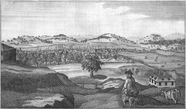
Between Cambridge Street and the high ridge of three peaks that made up the Trimountain, there were several streets laid out and a ropewalk or two, but few buildings or habitations. As the traveler passed the ropewalk on Belknap Street, he might notice people of African descent on the streets. A few men ran boardinghouses here that drew blacks and Indians from across New England. Bostonians muttered that bawdy houses were to be found nearby, hence the nickname of one of the hills: Mount Whoredom. The curious youth would probably be game to make the steep climb up Temple Street in order to reach the highest spot on the peninsula: 140-foot Beacon Hill. This peak was one of three in a row that gave Boston a distinctive profile when viewed from afar. Standing next to the beacon (a sixty-five-foot-tall crane, used for signaling danger to the surrounding countryside) and the great guns placed on the summit, visitors could “overlook all the Islands in the Bay, and descry such ships as are upon the Coast” (Figure 8). Below to the southwest was the forty-four-acre Boston Common. This large space was used largely for pasturing cattle and militia training. Except for a tree-lined promenade along one border, it had not been prettified. Left in its natural state, the Common was thought to offer a healthier environment than the city streets.5
Clambering down the south slope of Beacon Hill on a cow path lined with cedar trees and shrubs, our explorer could spot a number of elegant mansions, with extensive gardens, spread out along Beacon Street. If he kept going in a southeasterly direction, he would skirt the northeast side of the Common, putting the almshouse, workhouse, and town granary cluster on his left. Now he was entering the large expanse of the South End. Heading east on Milk Street would allow a circumnavigation of the district, allowing the walker to view the enormous ropewalks stretching along Hutchinson Street, note the South Battery jutting into the harbor, and then climb one of the steep lanes eighty feet to the top of Fort Hill to see its timber military works, thirty-fiveguns, and barracks housing Captain Jeremiah Green’s company of soldiers. Then, winding southwesterly along the shore, the traveler passed a long series of wharves and distilleries, punctuated by Windmill Point.6
Sparsely settled up until the 1750s, the South End was now the fastest growing district in Boston, with the number of inhabitants and artisans rivaling the North End. Yet in places it featured open space, with pastures, orchards, gardens, and barns integrated into large house lots.7 The walk down its main north-south artery, Newbury Street (called Marlborough and Orange in some sections) and approaching Frog Lane, led into a neighborhood of great elms, one of which in 1765 became the ceremonial center of the town’s resistance to British policy—the Liberty Tree. After another long block, our newcomer would pass only a few doors from the rented quarters on Hollis Street of the man paid to identify and warn strangers, Robert Love.
FIGURE 8. This view of Boston from the top of Beacon Hill shows the Common in the near distance, the South End and Boston Neck in the middle distance, and the Dorchester hills on the horizon. “South-east View of Boston,” by Samuel Hill, Massachusetts Magazine, 1790, p. 640.
Image courtesy of the American Antiquarian Society.
Farther down Orange Street was a fortified wall with openings—a checkpoint for travelers arriving in Boston by land. If the newcomer chose to venture farther, he would pass through the opening designed for pedestrians (there was a separate one for carts) and find himself on Boston Neck. Here the urban clutter and cacophony were gone. The narrow strip of land was so close to sea level that the spring tides often washed over sections of the road. Except for a few taverns, a small house with a barn, and some outbuildings, no other structures appeared on either side of the paved cart path. The open land here was used for saltworks, pasturing townspeople’s bulls, and the occasional horse race. A stretch of the path was lined with trees—alternating buttonwoods and elms. The gallows for the county of Suffolk stood on a small knoll, at a site that could accommodate the hundreds, even thousands, of people who attended corporal punishments and hangings. Shaking off this reminder of the brutal justice meted out to keep the king’s order, our youth might very well opt to seek lodging for his first few nights in Boston at the George Tavern. He would thus end up sleeping just a stone’s throw away from the Roxbury gate, which marked the bounds of Boston and which was the entrance point for visitors and newcomers who arrived by land.8