Mummy Pass Trail
Mummy Pass Trail runs from the Long Draw Reservoir Road past the national park’s northwestern boundary to a spot above Pingree Park, beyond the northern boundary. Both ends of the trail are in Roosevelt National Forest. The trail passes through what once was the remotest part of the park. The improvement of the road to Long Draw Reservoir to accommodate ordinary passenger cars has made the park’s northwestern corner more accessible, but it still is relatively uncrowded and a good place to spot deer and elk. During hunting season it is heavily patrolled by rangers to frustrate poachers.
To reach the Pingree Park end of the trail, from CO 14 take Pingree Park Road (CR 63E) 17 miles to the Tom Bennett Campground turnoff. A forest service sign marks the turnoff. Turn right past the campground, cross the South Fork of the Cache la Poudre River, and continue around a curve to a fork in the road, where you can park. Walk up the left fork toward Cirque Meadows and Emmaline Lake. This trail is a road for another 2.5 miles to the beginning of Mummy Pass Trail. This county road, however, tends to deteriorate to a four-wheel-drive adventure.
The road fords Fall Creek, and about 0.25 mile later the trail heads left (south) from the road. After zigzagging through subalpine forest for a couple of miles, it winds out of the trees and into the national park. Above tree line, the trail steepens somewhat until you reach the broad, nearly level top of a bench leading to Mummy Pass. On the way you must descend into a lush little valley holding two ponds and a multitude of flowers.
After hiking out of the valley, you can turn right (northwest) off the trail and climb steeply over tundra to Fall Mountain. The opposite (northern) side of the peak is glaciated dramatically, as is the entire ridge leading northwest to Comanche Peak. On the way to Comanche, skirt the big rocks at the heads of the cirques that indent this ridge, but walk to the edge now and then for the view.
From the top of Comanche, it is a long way north to any higher mountain. It is also a long way down to Emmaline Lake, Cirque Lake, and other smaller tarns at the head of Fall Creek. These lakes can be seen from intermediate peninsulas that project from the Fall-Comanche ridge, but the best view is from Comanche’s summit.
A circle route back to Pingree leads east down the north ridge above the Comanche cirque. Below this ridge you will hit a trail from Emmaline Lake that leads to the four-wheel-drive road. Follow the road down to your vehicle.
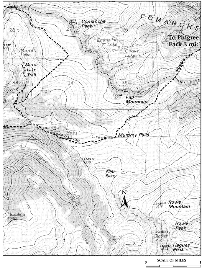
Mummy Pass sits on a broad tundra plateau between the Hague Creek and South Fork of the Poudre drainages, 1.5 miles from the northern boundary. As the trail winds across tundra and through subalpine forest, you see the Mummy Range from a unique if not particularly spectacular angle. More scenic from the plateau is the Never Summer Range to the southwest, with dramatic Mount Richthofen and Nokhu Crags dominating the skyline. Just past the crossing of Mummy Pass Creek, 1.8 miles from Mummy Pass, you arrive at a junction where the Mirror Lake Trail runs to the right (north).
Most hikers approach Mirror Lake from the western end of the Mummy Pass Trail, Corral Creek Trailhead. To reach this trailhead, drive along CO 14, which runs between Fort Collins and Walden. About 4 miles north of Cameron Pass, or 2 miles south of Chambers Lake, turn southeast onto the two-lane, gravel Long Draw Road (FR 156), which travels through Box Canyon and Corral Park, eventually ending at the western end of Long Draw Reservoir.
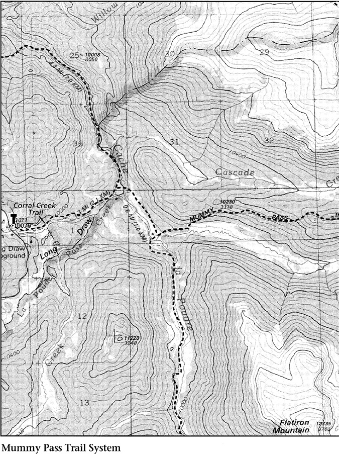
Drive about 8 miles on this road to the Corral Creek Trailhead and its parking lot. There is a campground, Long Draw, about 0.25 mile south of the trailhead.
The Mummy Pass Trail begins as an old road following Corral Creek but soon becomes a path. After less than 1 mile, you will reach the national park and a rather substantial bridge over the Cache la Poudre River. Another 0.6 mile of easy walking brings you to a junction with the Poudre River Trail. The Poudre River Trail (see Trails from Milner Pass in the Trail Ridge Road chapter) branches right (south); the Mummy Pass Trail continues east.
The Mummy Pass Trail meanders north of Hague Creek along a gentle open valley until a left bend takes you steeply up through thick woods. The grade moderates at the ridgetop, rising gradually to the junction on the left with the Mirror Lake Trail, 4.5 miles from the Corral Creek Trail.
The climb to Mirror Lake is an easy walk through subalpine forest until you reach a meadow where Cascade Creek flows still and wide, 0.7 mile from the Mummy Pass Trail.
There, branching sharply right from the main trail, a path heads straight up through the forest. Above tree line the route is steeper yet. Marked by cairns up the mountain, the trail levels west of Comanche Peak. There is nothing to be gained from striking out for the top of Comanche until the path flattens; premature departure probably will put you on an annoying false summit. Beyond Comanche Peak, the trail descends out of the national park to another junction; a sharp right turn there leads down, after about 4.0 miles, to Comanche Reservoir. This artificial lake is situated at the end of the road branching off the Pingree Park road to Tom Bennett Campground.
It may seem odd that some maps call the trail to Comanche Peak the Mirror Lake Trail when from the point of view of most hikers, it cuts away from Mirror Lake. The trail was named, though, when most visitors to the lake approached it from the north.
The final 1.0 mile of the trail to Mirror Lake passes through forest and flowered marshy meadows before reaching its destination. The lake, a classic tarn, was scoured by a glacier in the rock of a long cirque. This is tree line, so the lake at its outlet end is bordered by both erect subalpine fir and the shrubby krummholz version of the same tree. The far shore is rocky and barren, bordered by steep cliffs and snowbanks. The peaks that tower over the lake are no less dramatic for being unnamed. The lake itself has been shortchanged with a very common name for an uncommonly beautiful place.