Chapin Pass Routes
Chapin Pass is the back door to Mount Chapin, Mount Chiquita, and Ypsilon Mountain. Although the rugged, glacially carved east faces of these popular peaks are very visible and beautiful from the valleys around Estes Park, the less-precipitous western slopes rising above Chapin Pass offer the easiest routes to the top. Beyond Ypsilon you can continue to Desolation Peaks, Flatiron Mountain, or Fairchild Mountain. Chapin Pass is the highest point on the Chapin Creek Trail.
The easiest way to Chapin Pass is to drive to a small parking area by the side of the unpaved Old Fall River Road about 6.5 miles from its beginning at the western end of Horseshoe Park. Old Fall River Road is one-way uphill; after the hike you will have to continue on to Trail Ridge Road at Fall River Pass. (Overnight parking is prohibited at the parking area below Chapin Pass.) From the parking area follow the road for a few yards to the spot where the Chapin Creek Trail starts on the right (northern) side. Then follow the trail a short distance straight uphill to Chapin Pass.
If the Old Fall River Road is not yet open for the season and you are determined to hike through Chapin Pass, you must drive over Trail Ridge Road to Fall River Pass and begin there. Walk down the Old Fall River Road nearly to tree line. There you should angle off to the left and follow the ridgeline downhill to Chapin Pass, thus avoiding having to ascend to the pass from farther down the road.
Beginning at Fall River Pass adds almost 3.0 miles to the hike. It means that the final part of your trip, when you are tired, will be an ascent above tree line to reach your car. Furthermore, lightning-filled clouds may roll some excitement your way, forcing a retreat below tree line prior to climbing again toward Fall River Pass.
To climb Mount Chapin, Mount Chiquita, and Ypsilon Mountain, head east from Chapin Pass on a faint (“unimproved”) path that branches off the main trail. The branch trail soon climbs out of the trees, cuts around the southern flank of a hill on the ridge, and disappears amid rocks and tundra. Do not fret if you miss the path; once above tree line, it is a simple, steep trudge up the ridge to Chapin, the rounded summit farthest to the right.
Ascending this ridge to Chapin seems like a steeper and harder climb than either Chiquita or Ypsilon. Many hikers bypass Mount Chapin and head directly for these two higher peaks via the saddle between Chapin and Chiquita. By so doing, they miss good views down onto rock spires that rise from Chapin’s rugged southern side. As you approach the top, bypass Chapin’s western summit and head for the taller eastern one.
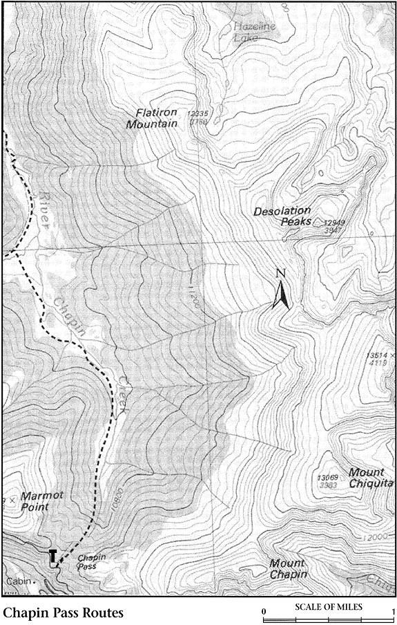
From Chapin descend about 400 feet to the Chapin-Chiquita saddle before ascending 1,000 feet to the top of Chiquita. You walk about 1.0 mile from summit to summit. The grade is not terribly steep; only the 13,000-foot elevation may pose minor problems. Chiquita is the easiest “thirteener” to climb in Rocky Mountain National Park.
If you are pressed for time or have a more distant goal, you can skip Chiquita and head straight for Ypsilon, 1.0 mile farther on. From the top of the snow-filled gullies that form a Y on the east face of Ypsilon, there is a spectacular view straight down to Spectacle Lakes, more than 2,000 feet below. Since you are likely to see this view in the morning, the reflected sun probably will be glaring off the water. A polarizing filter over the lens will eliminate the glare from photos.
Beyond Ypsilon the going gets tougher. Desolation Peaks are located 2.0 rugged miles of ridge clambering and cirque skirting north of Ypsilon. It is a similar 1.5 miles beyond Desolation to Flatiron Mountain.
Fairchild Mountain, northeast of Ypsilon, is usually climbed from Lawn Lake (see Trails North of Horseshoe Park). But Fairchild can also be reached from Ypsilon, a route that necessitates losing and regaining 1,000 feet of elevation over a couple of very steep and rough miles. If you plan to go to so much trouble, you might as well descend Fairchild via Lawn Lake and arrange for transportation at the trailhead in Horseshoe Park.
Back at Chapin Pass, a route descends very quickly to the marshy drainage of Chapin Creek. You will reach the valley floor in less than twenty minutes; I will refrain from guessing how long it will take to climb back out. This unmaintained 3.0-mile route is followed mainly by backpackers on their way to somewhere else via the Poudre River Trail (see Trails from Milner Pass in the Trail Ridge Road chapter). Your chances of seeing elk along Chapin Creek or the Poudre River are excellent.