Roaring Fork Trail System
The parking lot for the Roaring Fork trail system is on the right (east) side of the road, near the USFS Arapaho Bay Campground’s Roaring Fork Loop.
The Roaring Fork Trail heads east from the trailhead and climbs immediately through steep switchbacks above Arapaho Bay to a welcome level stretch that leads to a crossing of Roaring Fork. (Roaring Fork was a fork of Arapaho Creek until Lake Granby backed up, converting Arapaho Creek into Arapaho Bay.) In easy grades the trail follows the broad Roaring Fork Valley upstream, sometimes in marsh, sometimes in lodgepole pine. In a wide, shrubby meadow about 2.5 miles from the trailhead, turn right to recross Roaring Fork.
Beyond the crossing, a trail branches left (north), zigzagging 1.5 miles up to Watanga Lake. From the last of three level stretches, just below the last series of switchbacks up to the lake, is a fine view of the Fraser Valley below and the Continental Divide above. Flower-filled subalpine woods become ever more delightful as you climb higher. Finally you reach the top of a terminal moraine that dams Watanga Lake. The lake is relatively small, and the peaks above are not as spectacular as is normal in Indian Peaks. A gravel bottom around the edge supports water grasses, providing spawning habitat and good feeding areas for a rather dense trout population (mostly rainbows, some brown). This trail usually melts free of snow by mid-July.
Beyond the branch to Watanga Lake, the Roaring Fork Trail climbs steeply through deep woods and flowery meadows to the Irving Hale Divide, a broad saddle north of Mount Irving Hale. This section of trail has only a few switchbacks to lessen the grade. It is a real lung-popper until you reach the Irving Hale Divide. Here displays of wildflowers—tall chiming bells, yellow senecio, various colors of paintbrush—can be spectacular, especially where the trail sloshes through bogs. Paintbrush is also abundant in the drier subalpine meadows, along with some alpine flowers extending their range down from the tundra.
Mount Irving Hale is an easy climb up a tundra ridge from the Irving Hale Divide. On the double-humped top of Irving Hale are two large cairns. From a distance they look like two mountaineers standing watch over Hell Canyon. The summit is about 2.0 miles from the crossing of Roaring Fork.
Vistas from the top of Irving Hale are magnificent. To the west Lake Granby stretches out in Middle Park and the Gore Range defines the horizon. Mount Toll, Paiute Peak, and Mount Audubon tower on the southeastern skyline. Hell Canyon extends to the east, with Crawford and Long Lakes far below your feet at the base of craggy cliffs on Irving Hale.
Back down at the Irving Hale Divide, the trail descends slightly to the east past ponds and puddles. Early in the season, abundant glacier lilies testify to heavy snow accumulation. In a particularly lovely meadow with a fine view east to the Continental Divide, a tumbledown log cabin can add a romantic element to your photos.
Descending past this old sheepherder’s cabin, the trail drops along a ridge into Hell Canyon. Another view of Crawford Lake is visible during the descent. It is possible, from a point 1.0 mile below the Irving Hale Divide, to descend cross-country to Crawford and Long Lakes. A sometimes-faint path (which is strewn with much timber and is an arduous route, whether hiked up or down) continues down Hell Canyon to the Cascade Trail, Monarch Lake, and down 2.0 miles of road to Arapaho Bay Campground, where you began hiking.
The trail to Stone Lake continues, marked in faint stretches by rock cairns. Stone Lake lies in a stone basin that was scoured out by a glacier roughened into a rasping tool by the tons of rock it carried. Unlike many such tarns, Stone Lake is not particularly deep. Interspersed among the rounded rocks that form its shoreline are patches of subalpine meadow and trees of the forest’s upper margin. A narrow track leads up the valley over meadow and rock slabs to Upper Lake. The trail stops at Upper Lake, but you can continue upstream over flowery tundra meadows to a pass overlooking Paradise Park. From lake to pass is about 1.0 mile with a rise of 800 feet; the terrain makes for easy walking.
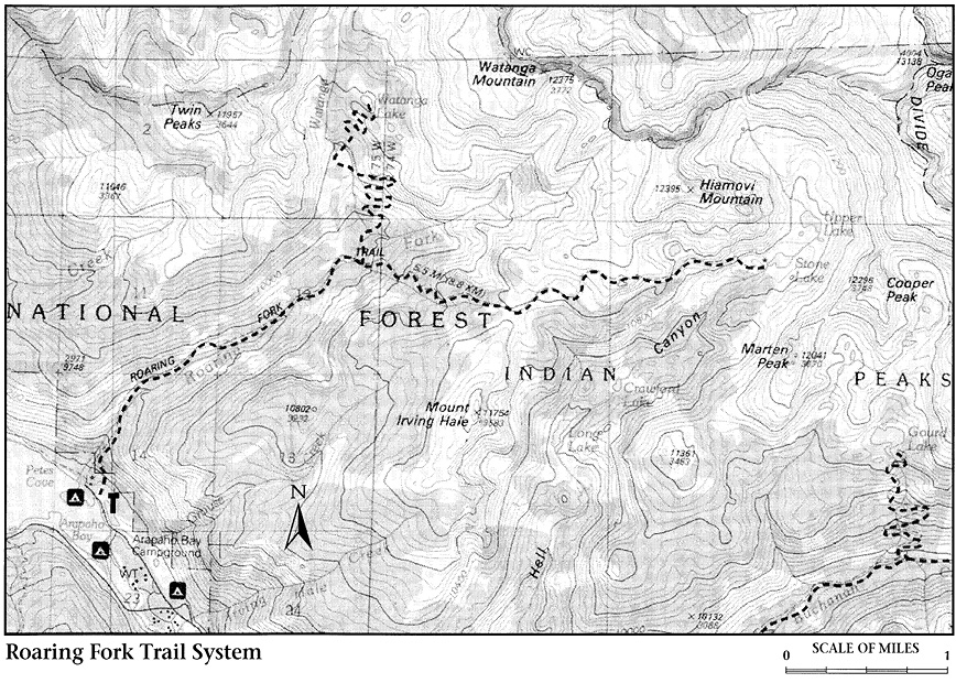
The pass is in a unique position between Paradise and Hell. But it is difficult to feel like Dante in a spot where both places are covered with tundra flowers and where Paradise and Hell are sublimely similar. Paradise Park lies within Rocky Mountain National Park and has been set aside as a research natural area. It is a preserve for scientific study; horses and camping are prohibited to maintain this remote mountain valley in a pristine condition. If you continue into Paradise Park, please be extra careful to leave no evidence of your passing.