1 Katy Trail
The former railroad right-of-way has gone from neighborhood eyesore to the place to see and be seen in uptown Dallas. It’s the closest thing North Texas hiking has to a singles bar, as the city’s buff and beautiful sweat out romance. Some couples have even married on the trail. But don’t feel put off if you’re not in the market. The trail welcomes all ages, as long as you don’t try to wander into the adjacent private homes and apartment complexes.
Distance: 5.0 miles out and back
Approximate hiking time: 1.5 to 2 hours
Trail surface: Concrete with side trail made out of pedestrian-friendly soft surface
Best season: Mar through June; Oct through Dec
Other trail users: Runners, cyclists, in-line skaters, dog walkers
Canine compatibility: Leashed dogs permitted
Fees and permits: No fees or permits required
Schedule: Park open daily 5:00 a.m. to midnight
Maps: TOPO! Texas CD; Friends of the Katy Trail map
Trail contacts: The trail is operated by the Dallas Parks and Recreation Department but is largely maintained and improved by the very active Friends of the Katy Trail; (214) 303-1180; www.katytraildallas.org.
Special considerations: The biggest bummer about the Katy Trail is the lack of restrooms. There are a few portable toilets in Reverchon Park but nothing along the trail. And don’t think you can slip into the woods—both sides of the trail are densely populated, and you could end up on someone’s back patio. At Knox Street you can stop for a drink at one of the bistros or grab a latte at a coffee shop and use the facilities, otherwise—sweat it out.
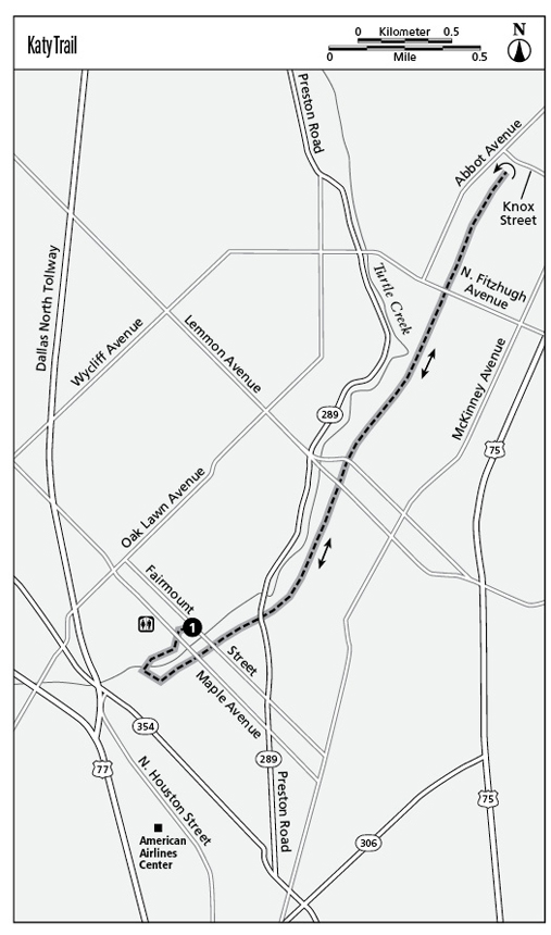
Finding the trailhead: From downtown Dallas, take Woodhall Rogers Freeway north to the Pearl Street exit. Go north on Pearl to Maple Avenue and follow Maple Avenue to entrance of Reverchon Park at 3535 Maple Ave. From the park’s parking lot, walk toward Turtle Creek. Exit at the stone bridge and veer right on the trail, passing playgrounds on the right. The trail winds up a hill by a stone pavilion to the Katy Trail. GPS: N32 48.078' / W96 48.625'
The Hike
Located on the old railbed of the Missouri-Kansas-Texas, or MKT, Railroad (nicknamed Katy for short), this trail was born in 1997 to preserve the narrow greenbelt and create an urban path traveling north from downtown Dallas to posh Highland Park and beyond. The 12-foot-wide concrete path is supplemented by an 8-foot-wide soft-surface trail for pedestrians in many but not all areas.
One of the easiest places to access the trail is from Reverchon Park, where the Friends of the Katy Trail, a volunteer organization of more than 1,200 enthusiasts, raised more than $1.5 million to construct an elaborate stone entrance. The trail actually begins 0.5 mile to the south. If time permits, you can take a right at the trailhead and hike the short distance to enjoy a view of downtown Dallas and the American Airlines Center.
From the Reverchon entrance, simply veer left and start heading north, walking between upscale apartment and office buildings on the right and leafy Turtle Creek on the left. The trail is a straight shot, with no street crossings up to Knox Street, the border of Highland Park. Mileage markers are embedded in the trail every 0.25 mile, beginning at the American Airlines Center. From the south the markers go up to 3.5 miles and then return to zero.
The trail is very well populated—crowded even on weekends and after work—making it feel relatively safe during those times. Dallas Police officers patrol the trail on bikes, and Friends of the Katy Trail can be spotted making the rounds on a golf cart. In 2008 the city added “911” markers every one-eighth mile along a 3.5-mile stretch of the trail. At the bottom of these markers, labeled KT-100 through KT-125, are numbers indicating the GPS coordinates to help determine your location in an emergency—the Katy Trail doesn’t have an official address.
The trail continues to grow, spreading north from Highland Park to Southern Methodist University, and should eventually connect to the Mockingbird DART Station and a trail heading east to White Rock Lake. The trail is great for people watching—both fellow hikers and cyclists on the trail and residents perched on patios overlooking the trail. (Some upscale developments now use the trail as an amenity to boost adjacent property prices.)
As you cross over Cedar Springs Road, take a look to your left toward Turtle Creek at the pinkish building styled like a sixteenth-century Italian Renaissance villa. That’s the luxurious Mansion on Turtle Creek hotel, where rock stars and other celebrities routinely hang their hats—and perhaps hit the trail.
Pass over Hall Street and Lemmon Avenue. Turn around at Knox Street, but be sure to go all the way to the intersection. Otherwise you might miss Christopher Janney’s soundscape titled Parking in Color, which creates what he calls “urban musical instruments” for passers-by.
Miles and Directions
0.0Start at Reverchon Park. Head uphill through the stone plaza to the trail entrance.
0.75Cross the bridge over Cedar Springs Road.
2.5Turn around at Knox Street and head south, retracing your route to trailhead.
5.0Arrive back at the trailhead.