6 Breckenridge Park
This 417-acre park is a popular destination, particularly during soccer season, when the parking lots are jammed with local families toting tykes to weekend games. This hike makes the most of the park’s 4.5 miles of trails, combining an out-and-back trail with a loop around the park’s ten-acre lake.
Distance: 3.0-mile lollipop
Approximate hiking time: 1 to 1.5 hours
Trail surface: Paved
Best season: Mar through May, when the wildflowers are in bloom
Other trail users: Families use the park’s wide trails to teach kids bike riding and to fish along the banks of the pond and adjacent Rowlett Creek.
Canine compatibility: Leashed dogs permitted
Fees and permits: No fees or permits required
Schedule: Park open daily sunrise to sunset
Maps: TOPO! Texas CD; trail maps available from Richardson Parks & Recreation. Pocket trail guides are available at Richardson City Hall, Heights Recreation Center, Huffhines Recreation Center, and the Senior Citizens Center.
Trail contacts: Richardson Parks & Recreation; (972) 744-4300; www.cor.net/parksandrecreation.aspx?id=3790/homepage.html
Special considerations: The city closes portions of the park after heavy rains.
In addition: Bring a camera for great shots of spring wildflowers and a pair of binoculars for bird watching.
Finding the trailhead: From Plano take President George Bush Turnpike east to the Renner Road exit. Turn left onto Renner. Travel north about 3 miles and turn right onto Brand Road. The park is located at 3300 Brand Rd. Turn right onto the entrance road, Park Vista Road, and follow it around to Parking Lot A. The trailhead is located directly across the road from the restrooms. GPS: N32 59.812' / W96 37.591'
The Hike
It’s hard to believe this pastoral escape is partially built on an old city landfill. Luckily the land was reclaimed, and now Breckenridge Park serves as a much-needed respite from the daily grind and gridlock of the Telecom Corridor, a nickname derived from the high-tech firms that call Richardson and its neighboring cities home.
The park contains more than twenty-five acres of wildflowers and was the former home of the city’s annual Wildflower! arts and music festival before the festival moved to the more urban Galatyn Park. Breckenridge Park is still the best viewing spot for the city’s annual July 4 fireworks display.
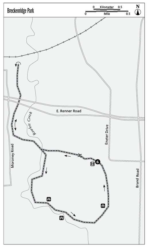
On other days the loudest noises you’ll hear are cheers from the dozen or so soccer fields, which draw area families for weekend games. To get to the trailhead, look for the primitive restroom facilities located by Parking Lot A. Cross the one-way street to the beginning of the paved trail. From here the trail heads down a gentle hill and away from the soccer fields.
When the trail splits, go right and cross a bridge over Rowlett Creek. The trail enters an open field and winds along the creek. Apart from soccer moms and dads, the park’s noisiest residents will likely be found along this part of the trail—the ducks and swans that waddle along the creek’s banks.
After passing under Renner Road, the trail dead-ends. Turn around here, making your way back by the creek and recrossing it.
Veer right at the trail split and then right again onto the trail that heads into the woods along the rushing waters of Rowlett Creek. Listen for woodpeckers, which frequent the cool, dense forest here.
The trail enters open space again, passing the park’s ten-acre lake on the left. The lake is stocked with bass, catfish, perch, and crappie, but anglers have to adhere to the park’s catch-and-release policy.
The trail winds around the lake, passing picnic pavilions and a playground before heading up a small hill back to the soccer fields and Parking Lot A.
Miles and Directions
0.0Start at the trailhead and veer left downhill.
0.1Go right at the trail junction. Cross a bridge and follow the trail into an open meadow along the creek.
0.5The trail passes under East Renner Road.
0.7The trail dead-ends. Turn around and circle back, retracing your route by the creek.
1.6Go right at the trail junction and right again when the trail splits, heading into the woods surrounding Rowlett Creek.
1.9Bear right at the trail juncture and pass a pond on the left.
2.5 Pass a picnic pavilion on the right and cross a bridge before looping back toward the parking lots.
3.0Arrive back at the trailhead.