12 Lake Grapevine Horseshoe Trail
This hike takes advantage of streets closed to traffic to enjoy a wide pathway through a post oak forest and to great views of Lake Grapevine. The trail goes past soccer fields, baseball diamonds, and a picnic pavilion, ending at a lakeside playground, making it a great outing for children.
Distance: 4.5 miles out and back
Approximate hiking time: 2 hours
Trail surface: Paved
Best season: Year-round
Other trail users: Cyclists, in-line skaters
Canine compatibility: Leashed dogs permitted
Fees and permits: No fees or permits required
Schedule: Park open daily 6:00 a.m. to 9:00 p.m.
Maps: TOPO! Texas CD; maps available online at www.grapevinetexas.gov
Trail contacts: City of Grapevine Parks and Recreation Department; (817) 410-3450; www.grapevinetexas.gov
Special considerations: This hike is gorgeous around sunset. Cabins and campsites are available at the Vineyards campground, which also offers kayak rentals and a geocaching program. For more information call (817) 329-8993 or visit www.vineyardscampground.com.
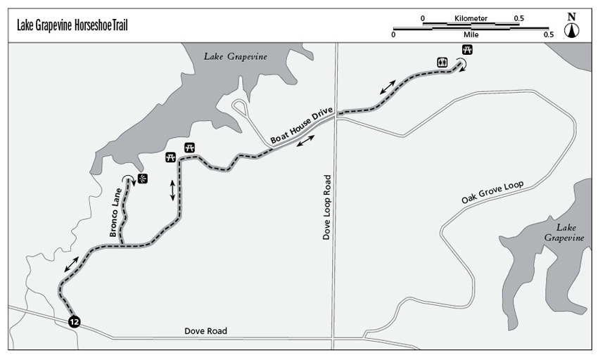
Finding the trailhead: Take TX 114 west from Dallas to Grapevine and exit at Park Boulevard, bearing right at the fork to stay on Park. Drive about 1 mile to intersection with Dove Road and turn left onto Dove. The parking lot for the trail is about 0.25 mile on the right. GPS: N32 57.345' / W97 06.308'
The Hike
Located on the south side of Lake Grapevine, which supplies water for Highland and University Park as well as portions of the city of Grapevine, this trail is only a few miles from bustling Grapevine Mills, Dallas/Fort Worth International Airport, and the massive Gaylord Texan resort. Thanks to those developments and others, the city enjoys a healthy tax base and offers first-rate parks, including this well-tended trail.
The first part of the hike, about 1.5 miles, is on an old paved park road that’s now open only to foot and bike traffic. Off-road cyclists take to side dirt trails that branch off the main trail.
The trail starts from the parking lot off Dove Road and then heads through a grassy opening, passing houses on the right and Little Bear Creek down the hill on the left. The trail then curves right.
At the junction with Bronco Lane, the trail follows the cul-de-sac down to the water’s edge for a good view of the lake. The trail then heads back up the street to pick up the main road, bearing left and heading downhill for another view of the lake on the left. The trail surface becomes concrete and heads up a hill, crossing over Dove Loop Road and into a post oak forest where squirrels scamper.
The trail enters Oak Grove Park, a hub of baseball and soccer fields and plenty of picnic tables filled with families on sunny weekends. A lakeside playground and nearby water fountains and restrooms make a nice resting spot before turning around and heading back to the trailhead.
Miles and Directions
0.0Start at the trail sign at the back of the parking lot. Stay on the wide paved street when you come to junctions with concrete-paved and dirt paths.
0.5Take Bronco Lane left to the end of the cul-de-sac. Retrace your steps after viewing the lake.
0.8Rejoin the main trail. Turn left and follow the road as it winds downhill with the lake on the left.
1.2Cross Dove Loop Road, and follow the path as it leads into the woods.
1.8Stay on the trail as it emerges from woods to an open area with soccer fields overlooking Lake Grapevine.
2.25The trail reaches a playground, your turnaround point. Retrace your steps back to trailhead.
4.5Arrive back at the trailhead.