18 Ray Roberts Lake State Park: Johnson Branch Trail
With well-marked paved trails, plenty of picnic tables, and a great swimming beach for a posthike dip, this loop is well worth the drive.
Distance: 3.5-mile lollipop
Approximate hiking time: 1.5 hours
Trail surface: Concrete pavement
Best season: Mar through Oct
Other trail users: Cyclists
Canine compatibility: Leashed dogs permitted
Fees and permits: Park entrance fee
Schedule: Park open daily 8:00 a.m. to 10:00 p.m.
Maps: TOPO! Texas CD; park maps available at the front gate or online at www.tpwd.state.tx.us
Trail contacts: Texas State Parks; (940) 637-2294; www.tpwd.state.tx.us
Special considerations: The park offers free guided nature walks on many Saturdays and occasional fireside chats and speakers at the Oak Point Amphitheater. For the latest schedule check www.tpwd.state.tx.us/newsmedia/calendar/?calpage=s0138
Finding the trailhead: From Denton take I-35 north to exit 483 and head east on FM 3007 for 7 miles. The park entrance is on the right. Continue straight from the entrance until the road ends at Oak Point parking lot. The trailhead is by the boat ramp and the fish cleaning station. GPS: N33 24.388' / W97 02.900'
The Hike
Lake Ray Roberts supplies water to the cities of Dallas and Denton and is named for longtime congressman Ray Roberts, who died in 1993. The lake encompasses two state parks—Isle du Bois and Johnson Branch—and a collection of protected wetlands and wildlife management areas. The nearby Lake Roberts Greenbelt offers 20 miles of trails, but this park tends to have fewer hikers, making it feel worlds away from the Metroplex even though it makes an easy day trip.
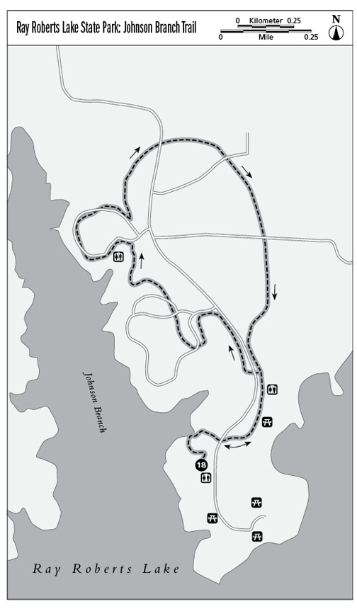
The trailhead is at the back of the park, all the way down the main road, by the boat ramp and fish cleaning station. Look for the concrete-paved trail and bear right, walking away from the parking lot. At about 0.12 mile you’ll see the entrance to the Vanishing Prairie Nature Trail. Go left and head into the forested area, which has educational markers identifying trees, plants, and area wildlife. The nature trail is a small loop that eventually returns to the same point.
Rejoin the mail trail and cross the park’s main road, heading toward a large swimming area by the lake. The trail follows the shoreline, passing picnic tables on the right. Bear left as the trail splits, crossing back over the park road and heading into the woods and away from the lake. The trail winds through the Juniper Cove camping area here and then meanders back into the woods, passing a chemical toilet on the right.
Cross back over the main park road and head into the woods, looping around until you join the trail back by the beach area. Finish your hike with a refreshing dip in the lake.
Miles and Directions
0.0Start at the trailhead by the boat ramp and fish-cleaning station adjacent to the parking lot.
0.12Bear left, following the Vanishing Prairie Nature Trail as it loops by a small pond.
0.4The nature trail rejoins the main trail. At the main trail bear left and go up small hill, crossing the park road and heading to the beach area.
0.5At the next trail split, go left, heading into the woods and away from lake.
0.7The trail crosses back over the main park road.
1.1Follow the trail through a camping area, bearing left as the trail rejoins the campground road and follows it around loop.
1.5Cross the main road and go right, heading into the woods as the trail loops around back to the beach.
2.5Follow the trail as it goes along the lake shoreline, heading back to parking lot and trailhead.
3.5Arrive back at the trailhead.