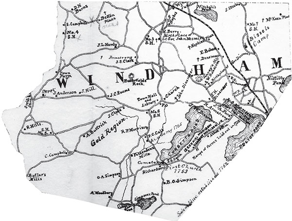
An 1880 map of Windham with several sites of historical significance marked. From History of Windham in New Hampshire (Rockingham County), 1719–1883.
1
A LOOK AT WINDHAM
In order to fully appreciate the many stories of Windham’s past, it is necessary to have a basic understanding of the historical layout of the town. The first detailed map of Windham was published in 1857 and recorded many of the local landowners and major geographical features. Another extensive map would not be completed until 1880, when a map of Rockingham County was compiled by Leonard A. Morrison for his history of Windham that was published three years later. This map contained the names of many Windham residents and geographical features, as well as several of the historical sites in town.
Historical names of local places are also evident on antique maps. For example, the small body of water on the eastern side of the map, labelled Hittitty Pond, has since been renamed Shadow Lake. Policy Pond, located just below Hittitty Pond, became known as Canobie Lake just a decade after the map was published. Maps, such as Morrison’s, also present historians with mysteries. On his map of Windham, Morrison labelled a large tract of land the Gold Region. Bounded by roadways on three sides and a stream on the other, the area contains some of the highest points of elevation in Windham. Curiously, Morrison never makes any other reference to the region in his book. It is likely Morrison copied the name from the 1857 map without knowing exactly what was meant by the cartographers who originally gave the region the moniker. To this day, no one has been able to successfully solve the mystery of Windham’s Gold Region.

An 1880 map of Windham with several sites of historical significance marked. From History of Windham in New Hampshire (Rockingham County), 1719–1883.
The roads are another prominent feature of Morrison’s map. Mentally navigating the system of roads provides an insightful look at the daily lives of Windham residents over one century ago. You can retrace the path many of Windham’s most well-known citizens traversed to reach the town hall or attend the Sunday service at the Presbyterian church. There are even some roads that still exist today, in almost the same location they were over one hundred years ago. Range Road is one such road. Located on the eastern side of Cobbett’s Pond, the road runs the entire length of the pond and beyond. Some of the earliest settlers of Windham lived in the vicinity of what is now known as Range Road. The roads are just one of a wealth of features offered on the earliest detailed maps of Windham. Featured in this introductory chapter, the 1880 map is an interesting look back into Victorian era Windham.