|
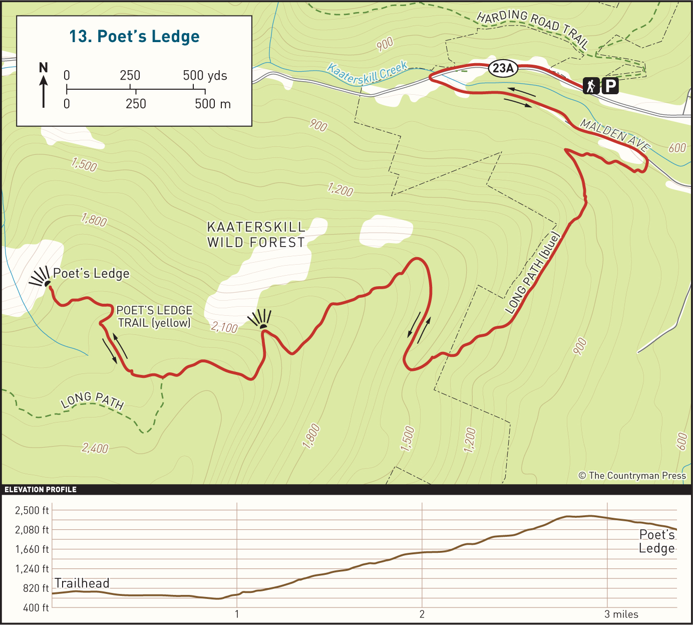
DISTANCE: 7 miles TYPE: Out and back TOTAL ELEVATION GAIN: 1,650 feet MAXIMUM ELEVATION: 2,350 feet DIFFICULTY: Difficult HIKING TIME: 4 hours |
The view from Poet’s Ledge is one of the best in the region, but the hike to the vista is a little more complicated. You’ll have to work more than usual to reach the viewing area, following an arduous ascent up an old dirt road, sandwiched between a short roadwalk at the beginning and a segment of relatively easy walking near the top. Don’t let the climb discourage you, though! This is an excellent hike offering a good deal of solitude in addition to the wonderful view from the ledge. At times the trail crosses private land. As always, be courteous and respect the landowner’s rights by staying on the designated trail.
There are blueberry bushes very close to the viewpoint, and when the fruit is ripe the area is frequently visited by black bears that can be quite protective of this plentiful food source. Be alert, exercise caution, and make sure you are educated on what to do in the event of a bear encounter.
GETTING THERE
Take Exit 20 (Saugerties) from the New York State Thruway, then turn left onto NY-212/NY-32. At the traffic light, take a right onto NY-32 North. In 6 miles, continue straight onto NY-32A. Follow NY-32A for 2 miles. In the small town of Palenville, make a slight left onto NY-23A and follow the road as it enters the Catskill Park. The parking area will be on your right just after crossing the park boundary, in about 100 feet. It is a small gravel lot, nestled in the trees a short distance off the road. If you reach a bridge crossing Kaaterskill Creek, you have gone too far. Do not park at the turnoff near the bridge.
GPS SHORTCUT
Search Google Maps for “NY-23A & White Road.” The parking lot is 0.2 mile up NY-23A to the west.
THE TRAIL
From the parking area, head to the road and turn right, following the street further into the park. The road can be busy at times, so stay on the shoulder and be cautious. You will walk alongside the road for 0.3 mile, crossing the bridge over Kaaterskill Creek when you come to it. On the other side of the bridge, turn left and cross the road. Once you cross the road, you will turn sharply to the left and follow a short segment of pavement heading back in the direction you came, this time on the opposite side of the creek. At the end of this short paved area, enter the woods, passing a guardrail, and continue to follow the remnants of an abandoned road for half a mile as it skirts the bank of Kaaterskill Creek.
When you emerge from the woods, walk a short distance onto Malden Avenue and turn right, heading uphill on a gravel road grade. There are aqua-green Long Path blazes marking the way. Shortly after turning onto the gravel road, you will turn right again at a DEC trail sign and head back into the woods, eventually passing a metal gate. This is the start of the long, steady climb out of Kaaterskill Clove. You will stay on this grassy dirt road for 0.6 mile, ascending the entire time. This section of the trail is on private land, so stay on the trail. Follow the aqua-green Long Path blazes, and veer to the right, leaving the road grade and continuing your climb on a footpath. When you cross the Kaaterskill Wild Forest boundary, blue trail markers will join the green Long Path blazes. The trail makes a hard turn to the right 0.3 mile after leaving the road grade, and then levels out for another 0.3 mile.
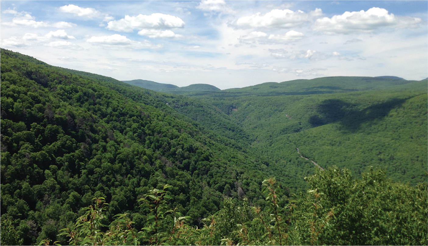
THE VIEW FROM POET’S LEDGE LOOKING WEST
Begin another steady ascent as the trail bends to the left, about half a mile after leaving the grassy road. Your course will take you up and over several very large stone ledges that cross the trail, like an oversized staircase. The trail will continue to steadily gain elevation, weaving through the forest. Roughly half a mile after resuming your ascent, you will come to a small open clearing on the right side of the trail. From here you can catch views of the cliffs on the opposite side of Kaaterskill Clove and see down into the valley below.
Continue to follow the trail uphill. The grade will begin to level shortly after you leave the ledge, and in about 0.3 mile you will come to a trail branching off to the right, marked by a sign. This is the spur trail that leads to Poet’s Ledge. You are now at the high point of this hike, 2.1 miles from leaving Malden Avenue. Turn right onto the trail and begin following the yellow blazes. The trail begins a moderate descent, winding through serene forest and passing a couple exposed rock ledges on the way.
After dropping 200 vertical feet over the course of half a mile, you will arrive at Poet’s Ledge. The yellow-blazed trail comes to an end here. This vista faces northwest, offering panoramic views of the mountainous landscape spreading out before you. The ledge drops off significantly, so be careful as you explore and enjoy the view. Make sure to bring a notebook and pen with you on the hike, as it is required that you write a poem from this vantage. (Of course, to complete the creative trifecta, you will also have to hike nearby Artist’s Rock, Guide #10, and Inspiration Point, Guide #11.)
When you are ready to leave, walk back up the yellow-blazed trail and turn left onto the Long Path. Retrace your footsteps back to the parking area. Be careful as you descend to the road grade, as rocky portions of the trail can be slippery, especially when wet.