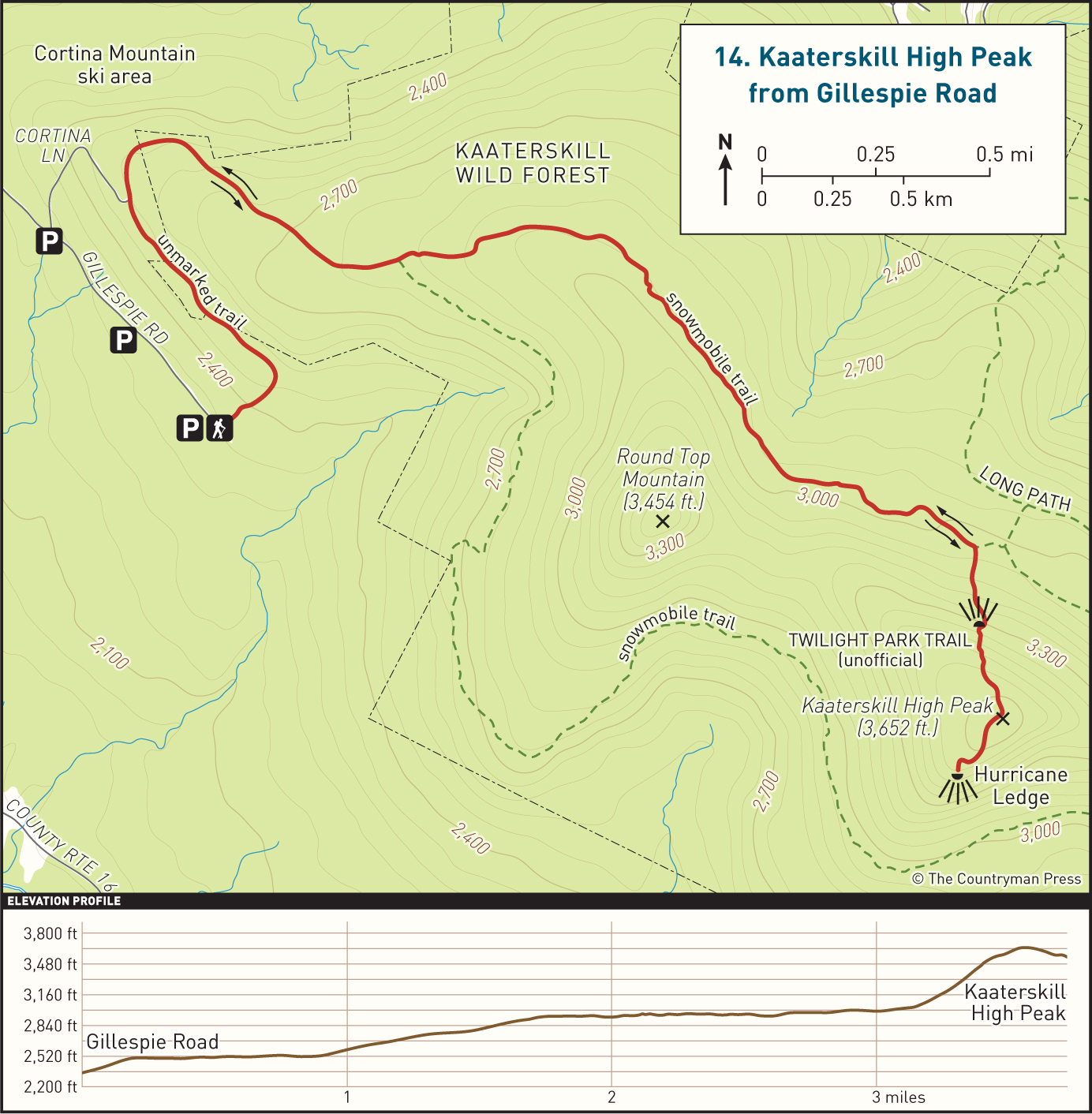
Kaaterskill High Peak from Gillespie Road
|
DISTANCE: 6.4 miles TYPE: Out and back TOTAL ELEVATION GAIN: 1,305 feet MAXIMUM ELEVATION: 3,655 feet DIFFICULTY: Easy HIKING TIME: 3.5 hours |
The easternmost Catskill mountain over 3,500 feet in elevation, Kaaterskill High Peak—with its distinct, easily recognizable profile and storied past—is an excellent hike for explorers and historians alike. The popular nineteenth-century painter Thomas Cole captured the mountain’s figure in several paintings, and this influence would help to establish Kaaterskill High Peak and neighboring Round Top Mountain as enduring icons of the Catskill Mountains. The peak was once thought to be the highest point in the Catskills, until resurveying determined it to be the twenty-third tallest peak, more than 500 feet shorter than the actual high point on Slide Mountain.
The hike described below is an easy approach from the south that entails a fairly painless climb along the lightly used snowmobile trail that circles the peak. The last half mile to the top is on an unmaintained section of trail that is fairly steep. Along the way you will experience firsthand some of the economic history of the mountain, and on the summit you will see the remaining wreckage of a plane crash that occurred in the late twentieth century. There are a few views at various points from which you can survey the surrounding landscape, looking north and south.
GETTING THERE
Take Exit 20 (Saugerties) from the New York State Thruway, then turn left onto NY-212/NY-32. At the traffic light, take a right onto NY-32 North. In 6 miles, continue straight onto NY-32A. In 1.9 miles, turn left onto Route 23A, and drive up the winding mountain road toward Tannersville. Remain on NY-23A for 6 miles before turning left onto Clum Hill Road, about a mile before reaching downtown Tannersville. Follow Clum Hill Road to a T intersection and turn left, taking Gillespie Road for about a mile until it ends at a grassy parking area on the edge of a field. The last half mile is a rocky dirt road that can be difficult to navigate if your vehicle sits low to the ground. There is additional parking roughly halfway up the dirt road, and just before Cortina Lane. Do not turn onto Cortina Lane, as this is a private driveway. You will have to walk to the end of Gillespie Road if you park at either of these two areas.
GPS SHORTCUT
Search Google Maps for “Gillespie Road, Elka Park, NY.” Your GPS will take you halfway up Gillespie Road. Continue to the parking area where the road ends.
THE TRAIL
From the parking lot at the end of Gillespie Road, pick up an old rutted dirt road next to a wooden fence and follow it, heading into the woods along the edge of an overgrown field. Although the trail here is unmarked, it is generally fairly easy to follow. You will keep on this path as it heads uphill for a short distance, about 0.2 mile. At this point the woods road will turn to the left and level off. You will walk parallel to the eastern shoulder of Round Top Mountain, which rises to your right, through forest predominantly composed of maple and beech trees. There is a fair amount of blowdown on this unmarked road, and you will occasionally have to leave the main grade of the trail to skirt around some of the bigger fallen trees, but you will always return to the uneven road to continue. Certain sections of this path can be muddy depending on the time of year, but you should have no problem traversing these soupy areas along the edge of the road.

THE EASTERN HALF OF THE DEVIL’S PATH, FROM HURRICANE LEDGE
About 0.9 mile from the parking area, you will emerge from the woods into a clearing where two gravel roads meet. These are the ruins of Cortina Mountain ski area, which was in business from 1975 to the early 2000s. There are a few dilapidated buildings still standing, as well as a ski lift system. From here you can see the Hunter Mountain ski area off to the west, as well as the East Jewett Range of mountains to the northwest. A small stand of trees blocks the view of Hunter village, which sits directly between these two mountain ranges. There is also a good view that faces north, looking out from the fern-covered ski lift swath, where you can see the Blackhead Range.
Reenter the woods by walking under the ski lift cables on a continuation of the dirt road, passing a run-down building on your left. You will pass through a gate immediately upon stepping back into the woods. This marks the start of a snowmobile trail that runs out and around the summits of Kaaterskill High Peak and Round Top Mountain. You will start to see markers along the side of the trail. Some of them will be red, and some of them will be yellow, but they both mark the same trail. Continue to follow the snowmobile trail for about 0.75 mile, climbing gradually on rocky road grade until you reach a sign that announces the start of the loop portion of the trail. Veer left and continue hiking along the snowmobile trail, which maintains the same relatively flat grade as before.
After 1.6 miles, you will come to a trail that bends to the right, marked by a small cairn. This is the unmaintained path that leads to the summit. If you reach a blue-blazed trail coming in on your left, you have gone too far and will have to backtrack about a tenth of a mile. Turn onto the unmaintained trail and begin climbing much more aggressively. The trail is rocky and steep, sending you past large overgrown boulders and through gaps in the ledges to ascend. You may need to use your hands in certain areas. There are a few weatherworn blue blazes still hung on the trees, and occasionally small cairns to mark the path, but it is easy to distinguish nonetheless. After about 0.3 mile of intense climbing, the grade will begin to lessen, and you should be able to cover ground much more quickly. The forest will transition to mostly balsam, spruce, and birch, and the trail will narrow. There is a decent view through a small break in the trees about 0.2 mile from the summit, through which you can catch a glimpse of the Blackhead Range to the north.
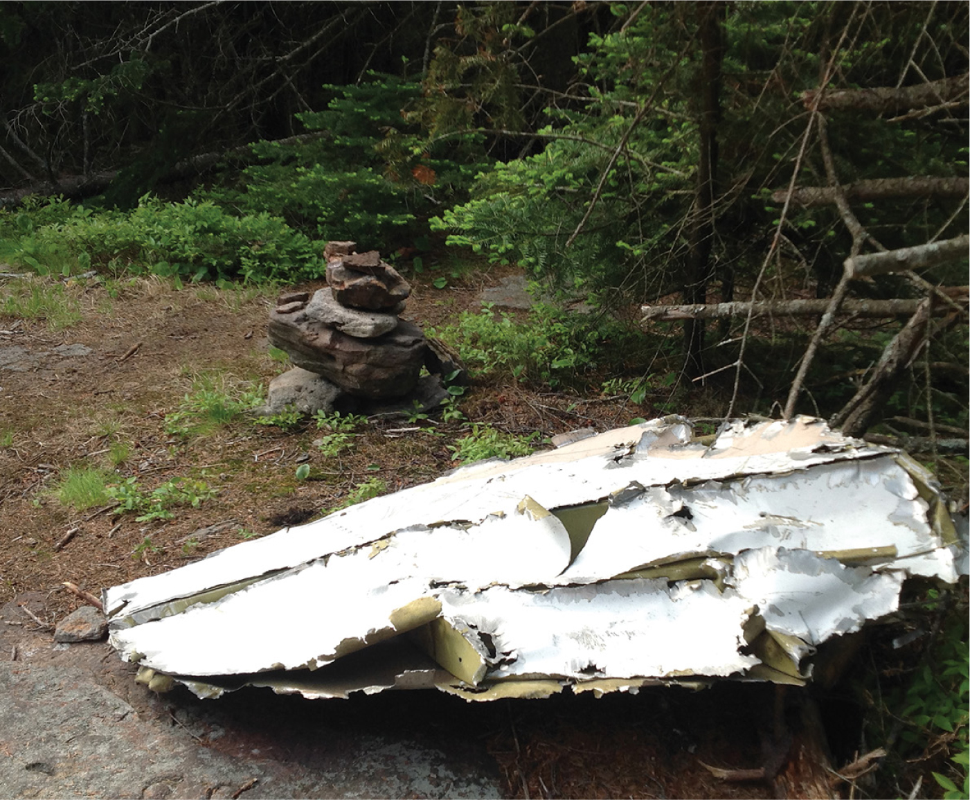
Half a mile after turning onto the unmaintained trail, you will reach the summit, a wide grassy clearing with a herd path heading straight on and another breaking off to the right. There are no views from here, but there is a piece of wreckage from a plane crash that occurred on the mountain in the 1980s, as well as a few USGS markers that you can find if you look around.
Pick up the herd path that goes straight on and follow it for about a tenth of a mile, heading south as it descends nearly 200 feet. It may be hard to follow, so take your time and reassess your route often. At the end of this little trail is Hurricane Ledge, a small rock outcropping that boasts 180-degree views of the surrounding landscape. To your left you can see Kaaterskill Clove, and to your right you can see Platte Clove, Indian Head Mountain, and Twin Mountain, the start of the Devil’s Path range. On a clear day you should be able to make out the fire tower on Overlook Mountain, which sits behind Indian Head, slightly to the left. The Hudson River serves as a nice backdrop to the scenery, stretching from north to south through the distant countryside below. This is an excellent place to enjoy a snack and take a break before making the trek back to the trailhead.
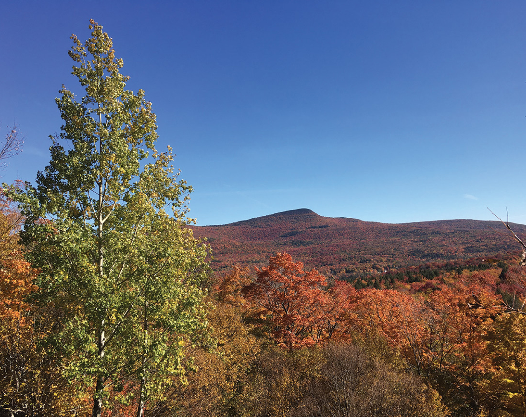
DISTANT KAATERSKILL HIGH PEAK
To return to your car, reverse your course and take the unmaintained trail downhill to the snowmobile path. Turn left and follow the red and yellow markers to the old ski area, at which point you will join the run-down forest road and walk its length back to the parking lot.