This complex multidisciplinary science attempts to establish the mutual relations of living beings (biosphere) and atmospheric processes over long periods.
In this book, we deal with bioclimatology as an environmental science that deals with the relationship between climate and the distribution of plants and plant communities on the surface of the Earth, according to the methodology of the bioclimatic classification of the Earth by Rivas-Martínez.
The importance of temperature and precipitation in the distribution of plants and plant communities is well known. Both are basic climatic elements in the set of parameters and indices used by bioclimatology to establish physical frameworks (bioclimatic territories) in which living beings develop.
distributional areas of plants and simple plant communities defined through classical phytosociology,
vegetation series or sigmeta. These are plant communities linked by the process of succession within similar teselar territories, which are ecologically homogeneous territories and potentially able to sustain a single type of potential vegetation,
geoseries or geosigmeta, (contacting series along an ecological gradient),
geopermaseries (concatenation of permanent communities),
This global bioclimatic classification establishes five major macrobioclimates for the Earth: Tropical, Mediterranean, Temperate, Boreal and Polar. These, and their subordinate units or bioclimates, are inhabited by particular plant communities and formations. Within the bioclimates there are a certain number of variations in the seasonal rainfall rhythms: bioclimatic variants. In addition, thermal and ombric territories are established according to certain thermal and pluviometric index ranges: thermotypes and ombrotypes, used to definine the bioclimatic belts.
According to this classification, the Canary Islands are included in the Mediterranean macrobioclimate. This is an extratropical macrobioclimate, whose main characteristic is the existence of a dry period (P < 2 T) lasting at least two months after the summer solstice. Of the eight bioclimates that it encompasses, four are recognized in the Canaries: hyperdesertic-oceanic, desertic-oceanic, xeric-oceanic and pluviseasonal-oceanic.
3.1 Bioclimatic Belts
Thermotypes recognized in the Canary Islands and threshold values for Itc and Tp (Rivas-Martínez 2011)
Thermotype | Index value | Horizon | ||
|---|---|---|---|---|
Itc | Tpa | Itc | ||
1. Inframediterranean | 580–450 | > 2.400 | Lower: | 580–515 |
Upper: | 515–450 | |||
2. Thermomediterranean | 450–350 | > 2.100 | Lower: | 450–400 |
Upper: | 400–350 | |||
3. Mesomediterranean | 350–220 | > 1.500 | Lower: | 350–285 |
Upper: | 285–220 | |||
Itc/Tp | ||||
4. Supramediterranean | < 220 | > 900 | Lower: | 220–150/1500–1200 |
Upper: | 150–(120)/1200–900 | |||
5. Oromediterranean | – | 450–900 | Lower: | −/900–675 |
Upper: | −/675–450 | |||
Ombrotypes recognized in the Canary Islands and threshold values for Io (Rivas-Martínez 2011)
Ombrotype | Index value | Horizon | |
|---|---|---|---|
Io | Io | ||
1. Hyperarid | 0.2–0.4 | Lower | 0.2–0.3 |
Upper | 0.3–0.4 | ||
2. Arid | 0.4–1.0 | Lower | 0.4–0.7 |
Upper | 0.7–1.0 | ||
3. Semiarid | 1.0–2.0 | Lower | 1.0–1.5 |
Upper | 1.5–2.0 | ||
4. Dry | 2.0–3.6 | Lower | 2.0–2.8 |
Upper | 2.8–3.6 | ||
5. Subhumid | 3.6–6.0 | Lower | 3.6–4.8 |
Upper | 4.8–6.0 | ||
6. Humid | 6.0–12.0 | Lower | 6.0–9.0 |
Upper | 9.0–12.0 | ||
A few climatic values and indices are enough to establish the thermotypes and ombrotypes:
Compensated Thermicity Index (Itc)

It (thermicity index) = (T + M + m) × 10
T = mean annual temperature
M = mean maximum temperature of the coldest month of the year
m = mean minimum temperature of the coldest month of the year
C = compensation value
When the continentality index (Ic = difference between mean temperatures of the warmest and coldest months of the year) is <8 (oceanic) or >18 (continental), a compensation value (C) is subtracted or added to It to obtain Itc. This value is used in the territories outside the eutropical latitudinal zone of the Earth (north of 23°N and south of 23°S) to compensate for the extra winter cold of highly continental territories or the extra winter warmth in highly oceanic ones, so that the resulting compensated thermicity index (Itc) is comparable all around the Earth. In the Canaries, only Ic values <8 require compensation. Such compensation values are obtained from: C = (8.0−Ic) × 10.
Positive Temperature (Tp)
is the value in tenths of degrees resulting from the sum of the monthly means above 0 °C. In cold climates, when Itc < 120 or when Ic > 21, the positive temperature shows greater accuracy than Itc for determining thermotypes.
Ombrothermic Index (Io)
is a pluvio-thermal coefficient used to establish bioclimates, subdivisions of the macrobioclimates, and ombrotypes, territorial entities characterized by their rainfall values balanced with their corresponding thermal values. The Io is defined as follows: Io = (Pp/Tp) × 10.
Positive Rainfall (Pp)
is the annual rainfall in mm, taking into account only the months with mean temperature higher than 0 °C. Since this is the case for all the available thermopluviometric weather stations in the archipelago, except on Mount Teide approximately above 3000 m (N facing) and 3200 m (SE facing) where subzero mean temperatures are recorded in winter time, Pp generally has the same value as P (mean annual rainfall).
With trade-wind clouds (c), which refers to windward areas directly affected by clouds all year round, although with diverse intensity;
With overflowing trade-wind clouds (oc), which refers to leeward slopes under the influence of clouds overflowing from the windward slopes;
With trade-wind clouds except in summer (ces), as normally occurs on windward slopes above about 1250 m a.s.l.;
Without trade-wind clouds (wc).
Bioclimatic belts recognized in the Canary Islands

Bioclimatic combinations and climatophilous vegetation series in the Canary Islands


La Palma. Map showing the correspondence between bioclimatic belts and climatophilous vegetation series, as detailed in the legend and in Table 3.4 (Based on Garzón et al. 2014, corr)
3.2 Bioclimatic Belts in the Canary Islands

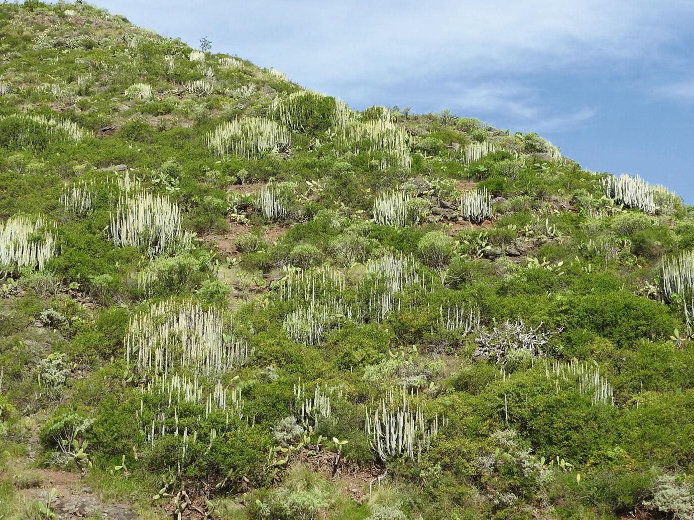
Asterisco intermedii-Euphorbio balsamiferae S. growing within the territory of the arid Inframediterranean bioclimatic belt. Malpaís de La Corona. Lanzarote

Periploco laevigatae-Euphorbio canariensis S. growing within the territory of the lower-semiarid Inframediterranean bioclimatic belt. Valle Jimenez. Tenerife

Brachypodio arbusculae-Juniperetum canariensis S. growing within the territory of the upper-semiarid Thermomediterranean bioclimatic belt. Agulo-Vallehermoso. La Gomera

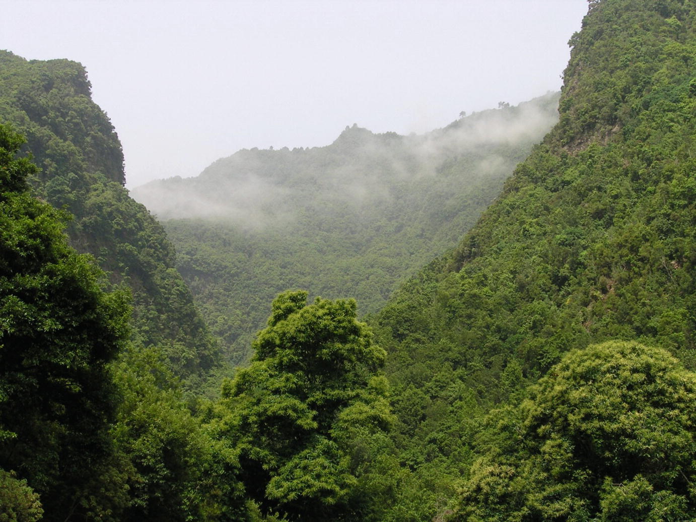
Ixantho viscosi-Lauro novocanariensis communities growing within the territory of the subhumid-humid Thermo-Mesomediterranean bioclimatic belt. Laurel forest of Los Tilos. La Palma

Loto hillebrandii-Pino canariensis S. growing within the territory of the subhumid Mesomediterranean (wc) bioclimatic belt. Caldera de Taburiente. La Palma

Spartocytiso supranubii S. growing within the territory of the dry Supramediterranean bioclimatic belt. Las Cañadas. Tenerife
Common names and scientific names of climatophilous vegetation series
Community common name | Vegetation series name |
|---|---|
Sweet spurge shrubland | Asterisco intermedii-Euphorbio balsamiferae S. (L) |
Lycio intricati-Euphorbio balsamiferae S. (F) | |
Euphorbio balsamiferae S. (C) | |
Ceropegio fuscae-Euphorbio balsamiferae S. (T) | |
Neochamaeleo pulverulentae-Euphorbio balsamiferae S. (G) | |
Echio breviramis-Euphorbio balsamiferae S. (P) | |
Rubio fruticosae-Euphorbio balsamiferae S. (H) | |
Cardón shrubland | Asterisco intermedii-Euphorbio balsamiferae S. aeonietosum lacerotensis (L) |
Kleinio neriifoliae-Euphorbio canariensis S. (F) | |
Aeonio percarnei-Euphorbio canariensis S. (C) | |
Periploco laevigatae-Euphorbio canariensis S. (T) | |
Euphorbio berthelotii-canariensis S. (G) | |
Echio breviramis-Euphorbio canariensis S. (P) | |
Aeonio valverdensis-Euphorbio canariensis S. (H) | |
Thermo-sclerophyllous woodland | Convolvulo lopezsocasii-Oleo cerasiformis S. (L) |
Micromerio rupestris-Oleo cerasiformis S. (F) | |
Pistacio lentisci-Oleo cerasiformis S. (C) | |
Junipero canariensis-Oleo cerasiformis S. (T) | |
Brachypodio arbusculae-Junipero canariensis S. (G) | |
Rhamno crenulatae-Junipero canariensis S. (P) | |
Rubio fruticosae-Junipero canariensis S. (H) | |
Thermo-sclerophyllous woodland, humid faciation | Junipero canariensis-Oleo cerasiformis S. ericetosum arboreae (T) |
Brachypodio arbusculae-Junipero canariensis S. ericetosum arboreae (G) | |
Rhamno crenulatae-Junipero canariensis S. ericetosum arboreae (P) | |
Rubio fruticosae-Junipero canariensis S. ericetosum arboreae (H) | |
Dry laurel forest | Echio handiense-Visneo mocanerae S. (F) |
Visneo mocanerae-Arbuto canariensis S. (C,T,G,P,H) | |
Humid laurel forest | Lauro novocanariensis-Perseo indicae S. (C,T,G,P,H) |
Cold laurel forest | Pericallido murrayii-Morello fayae S. (C,T,P,H) |
Violo rivinianae-Morello fayae S. (G) | |
Canary pine forest | Pino canariensis S. (C) |
Sideritido solutae-Pino canariensis S. (T) | |
Cisto gomerae-Pino canariensis S. (G) | |
Loto hillebrandii-Pino canariensis S. (P) | |
Bystropogono ferrensis-Pino canariensis S. (H) | |
Canary pine forest, humid faciation | Pino canariensis S. (C) ericetosum arboreae |
Sideritido solutae-Pino canariensis S. (T) ericetosum arboreae | |
Cisto gomerae-Pino canariensis S. (G) | |
Loto hillebrandii-Pino canariensis S. (P) ericetosum arboreae | |
Bystropogono ferrensis-Pino canariensis S. (H) ericetosum arboreae | |
Summit broom shrubland | Descurainio bourgeauanae-Spartocytiso supranubii S. (T) |
Spartocytiso supranubii S. (T) | |
Genisto benehoavensis-Adenocarpo spartioidis S. (P) | |
Teide violet community | Violo cheiranthifoliae S. (T) |
3.3 Bioclimographs


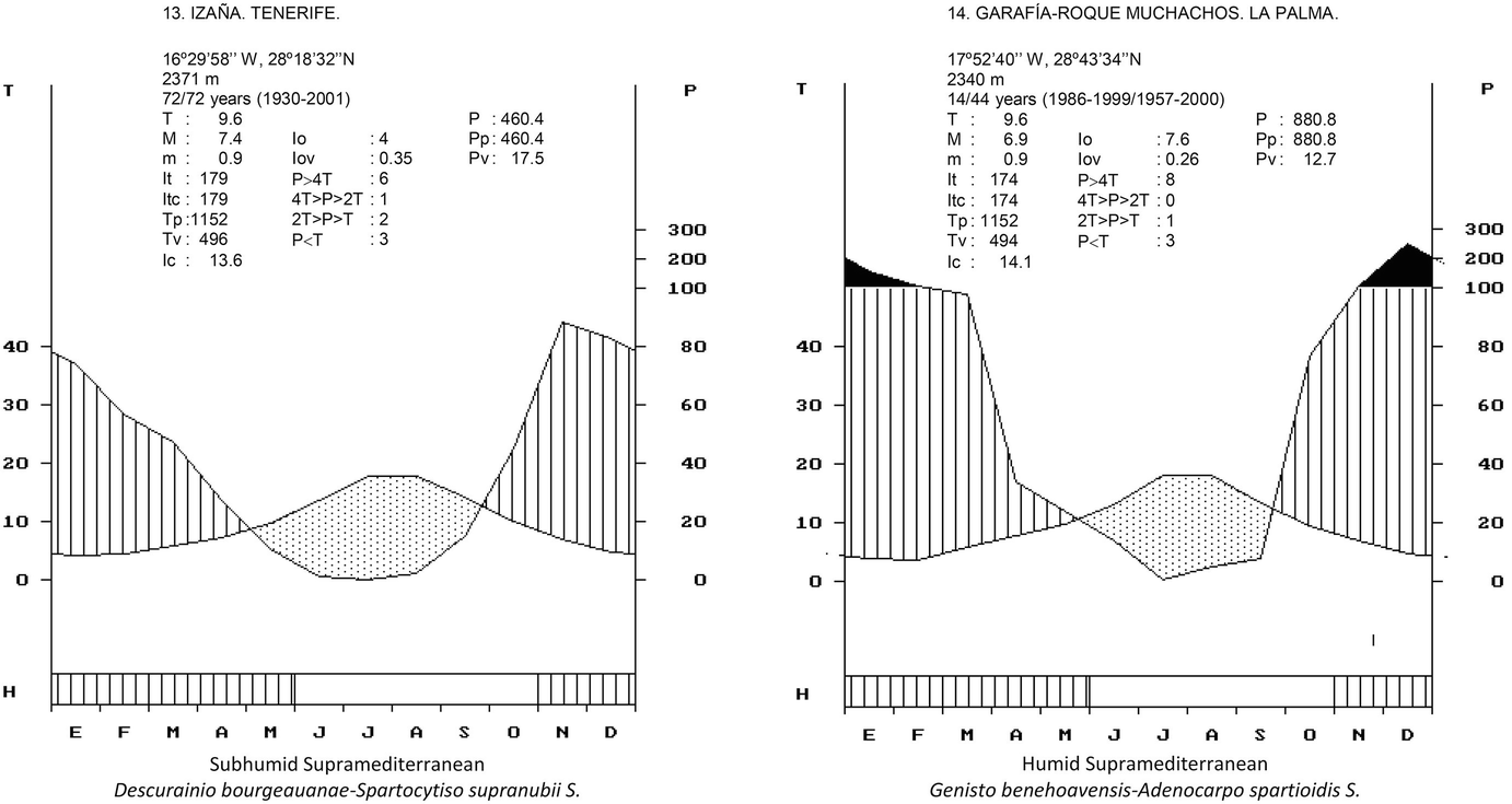
Bioclimographs of selected meteorological stations in the archipelago showing parameters and indexes for the usual bioclimatic belts and their relation with climatophilous vegetation series. T = Mean annual temperature in °C; M = Mean maximum temperature of the coldest month; m = Mean minimum temperature of the coldest month; It = Thermicity index; Itc = Compensated thermicity index; Tp = Positive temperature; Tv = Summer temperature; Ic = Continentality index. Io = Ombrothermic index; Iov = Summer ombrothermic index; P > 4 T = Months in which the rainfall value (in mm) is greater than four times the temperature value (in °C); 4 T > P > 2 T = Months in which the rainfall value is between twice and four times the temperature value; 2 T > P > T = Months in which the rainfall value is greater than the temperature value but smaller than two times this value; P < T = Months in which the rainfall value is smaller than the temperature value. P = Annual rainfall in mm; Pp = Positive rainfall; Pv = Summer rainfall. H: Frost period [blank = frost-free period (mi > 0 °C); black = frosts certain (mi ≤ 0 °C); hatched = probable frosts (m′i ≤ 0 °C); mi = monthly mean daily minimum temperature; m′i: monthly mean absolute minimum temperature]. (c): With trade-wind clouds; (oc): With overflowing trade-wind clouds; (ces): With trade-wind clouds except in summer; (wc): Without trade-wind clouds