
Mount Dana
TRAIL USE
Day Hike
LENGTH
5.6 miles, 4–6 hours as a day hike
VERTICAL FEET
One-way: +3,140', –20'
Round-trip: ±3,160'
DIFFICULTY
TRAIL TYPE
Out-and-Back
FEATURES
Summit
Wildflowers
Great Views
Steep
Geological Interest
FACILITIES
Bear Boxes
Campgrounds
Entrance Station
Restrooms
Shuttle Stop
Dark glasses and good health are both necessary for this climb to the second-highest summit in Yosemite. Only Mount Lyell exceeds it—by about 60 feet—but the Lyell summit is distant, and it requires mountaineering skills. Because Dana is such an accessible big peak, it is very popular, and on weekends you may find dozens of people ascending it. Its summit views are among the Sierra’s best, but turn back if the weather looks threatening.
Maps
This trail is covered by the Tom Harrison Yosemite High Country and Mammoth High Country maps (1:63,360 scale), the National Geographic Trails Illustrated #308 Yosemite NE map (1:40,000 scale), and the USGS 7.5-minute series Tioga Pass and Mount Dana maps (1:24,000 scale).
Best Time
Because this route is between just under 10,000 feet and just over 13,000 feet, snow can linger and obscure parts of the trail, particularly on the middle section, until early July. Higher up, on the windswept slopes, snow often is blown away during winter storms and is snow-free earlier. Both July and August are good months for the ascent, with warm temperatures, but be sure to check the weather forecast; this is not a hike to embark on if thunderstorms threaten. September is fine too, cooler, but with a lower chance of thunderstorms terminating your summit bid. If you dress properly, the usually chilly early- and mid-October days can be rewarding because the crowds are gone and the sky is a brilliant blue.
Probably in the 1930s, Yosemite’s eminent botanist, Carl Sharsmith, established this route to minimize impact to the fragile alpine environment. In 2013 Yosemite National Park restored many of the parallel trails created by hikers and formalized a single main route, again to protect the surrounding vegetation. Please keep to the trails in a location where vegetation grows by the inch and dies by the foot.
Finding the Trail
The trail begins on Tioga Road (CA 120) at Tioga Pass, the park’s eastern entrance. The entrance station is 7 miles east of the Tuolumne Meadows Campground and 12 miles west of the US 395–CA 120 junction in Lee Vining. If you are coming from Lee Vining (from the east), consider parking in the large pullout just before you reach the entrance station because parking is quite limited once in the park. For those coming from the Tuolumne Meadows direction, the Gaylor Lakes Trailhead or a parking lot across the street from it are the best choices.
There are three shuttle buses a day from the Tuolumne Meadows Lodge; if you are staying at the Tuolumne Meadows Campground and wish to use this service, the times are detailed in the newsletter you received when you entered the park. There are toilets across the street at the Gaylor Lakes Trailhead, but the closest water is at Tuolumne Meadows or one of the campgrounds east of Tioga Pass.
Trail Description
From Tioga Pass, ▶1 the footpath starts due east, then meanders southeast between two ponds that are among two dozen that developed when the last major glacier retreated. After 0.4 mile your path starts a moderate ascent, but shortly flattens again and turns south for a delightful traverse through the aptly named Dana Gardens. A mixture of the nutrient-rich metamorphic soils and moisture seeping down the slope makes this one of the most colorful wildflower patches in Yosemite—and that is saying a lot. Indeed all elevations on Mount Dana boast an astounding diversity of species. All too soon the flattish botanical interlude abruptly ends and a steep climb ensues (0.8 mile), ▶2 though endless flowers continue to decorate the rocky soils: larkspur, monkshood, spotted fritillary, phlox, western flax, and, soon after the snow melts, the delicate little rock star flowers. The steep, vaguely switchbacking trail continues relentlessly upward, bidding the last trees goodbye, passing a jumble of boulders that marmots and pikas call home, and slowly leaving behind the vegetated lower slopes. Continuing on talus and passing some long-lasting snow slopes, the slope rolls over to an alp. Having completed half the climb, a rest is due in this miniature alpine pasture, and a handy wind shelter is the perfect place to lean back and relax as you stare at the expanding vista (1.75 miles). ▶3


The landscape is briefly flatter as you traverse a flower-dotted plain—alpine tundra—toward the rocky slopes above. Several use paths, one more prominent than the others, head up the rubbly slopes of ancient rock to the windblown summit. Up here, it’s necessary to wear a hat and dark glasses and cover your skin with sunscreen to protect yourself from the strong rays. Continuing in a southeasterly direction you follow the steep trail straight up the slope ahead. The path is bouldery and you are constantly high-stepping to surmount the next rock. Tall cairns—rock towers—indicate the direction the trail takes, first leading you straight up and then slowly trending south (right). As you climb, the panorama continually expands with elevation, saturating the optic nerves with overpowering vistas. What you don’t see until you are just feet from the top is the summit itself—you just sense that the trail is becoming steeper and the ridges to your left and right are converging. Take the ascent slowly because the atmosphere is thin and in your euphoria you can easily overexert yourself. Being above the 12,000-foot elevation, July hikers may see the sky pilot blooming, with its dense head of blue flowers.

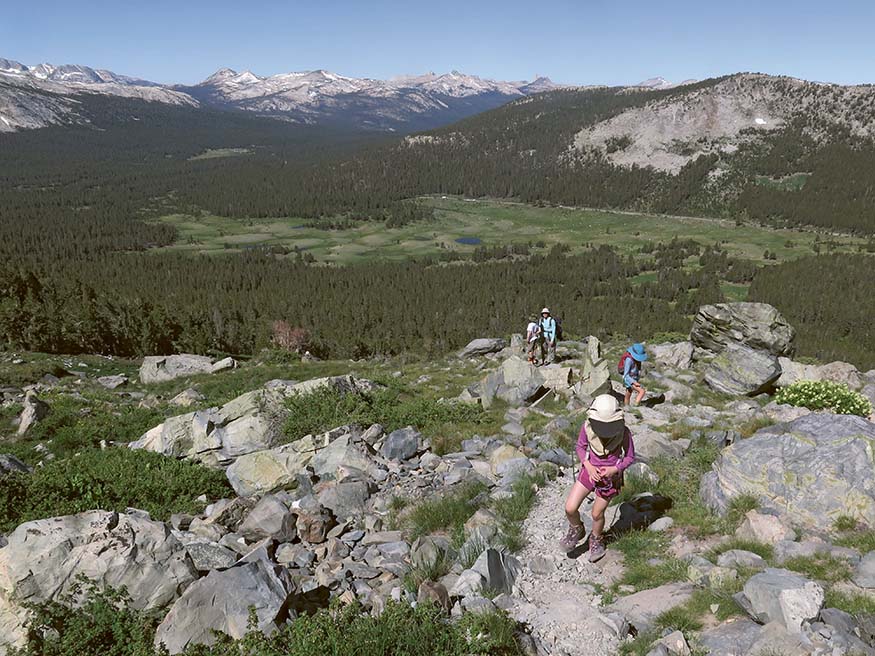
View back to Tuolumne Meadows on the hike up Mount Dana
At Mount Dana’s summit (2.8 miles), ▶4 at about 13,057 feet, your exhausting efforts are rewarded by a stupendous 360-degree panorama. The Sierra’s eastern escarpment can be viewed as far as the Wheeler Crest, about 40 miles to the southeast. East of it extends a long north-south mountain chain, the White Mountains. At the north end of the White Mountains stand the pale, isolated twin summits of Montgomery and Boundary Peaks, both over 13,000 feet high. Below these twin summits rises Crater Mountain, the highest of Mono Domes’ (formerly Mono Craters) many volcanic summits and, like most of them, fewer than 10,000 years old. The youthfulness of Mono Domes strongly contrasts with the age of the ancient giant, orbicular Mono Lake, directly north of them, which may be over 1 million years old. During glacial times, Mono Lake was much larger than today. At its maximum size, Lake Russell—glacial Mono Lake—was about 345 square miles in area and up to 950 feet deep, versus about 86 square miles and 186 feet deep in historic time before Los Angeles started diverting water away from it.

Continuing your counterclockwise scan west, you see deep-blue Saddlebag Lake and, above it, the serrated Shepherd Crest. Next comes pointed North Peak, then a true “Matterhorn,” Mount Conness. Beyond a sea of dark-green lodgepoles lies Tuolumne Meadows and its sentinel, Lembert Dome, whose bald summit appears nearly flat from this altitude. On the skyline above them stand Tuolumne Peak and Mount Hoffmann, while south of these stand the craggy summits of the Cathedral Range. Examining the range counterclockwise, you can identify blocky Cathedral Peak, north-pointing Unicorn Peak, clustered Echo Peaks, and the adjacent Cockscomb plus the finlike Matthes Crest extending south from it. A bit farther are sedate Johnson Peak, more profound Rafferty Peak, and broad Tuolumne Pass, through which former Tuolumne glaciers overflowed into the Merced drainage.
To the south-southwest stands the park’s highest peak, Mount Lyell (13,114'), flanked by Mount Maclure to the west and pointed Rodgers Peak to the southeast. Mount Ritter and Banner Peak barely poke their triangular summits above Kuna and Koip Peaks, while more rounded Parker Peak and Mount Wood stand above closer Mount Gibbs, and Mount Lewis, of intermediate distance, projects just east of them.
On your descent to your trailhead, try to retrace the way you ascended, resisting the temptation to attempt a different route down (5.6 miles). ▶5 While your path was straightforward, albeit exhausting, all other routes ascending Mount Dana are trickier, and most use trails peter out before the bottom.

| ||
▶1 | 0.0 | Start at Mount Dana Trailhead at Tioga Pass |
▶2 | 0.8 | South end of Dana Gardens |
▶3 | 1.75 | Halfway rock shelter |
▶4 | 2.8 | Mount Dana’s summit |
▶5 | 5.6 | Return to Mount Dana Trailhead |
 MILESTONES