Gaylor Lakes and Great Sierra Mine
TRAIL USE
Day Hike,
Child-Friendly
LENGTH
4.0 miles, 2–4 hours
VERTICAL FEET
One-way: +1,110', –240'
Round-trip: ±1,350'
DIFFICULTY
TRAIL TYPE
Out-and-Back
FEATURES
Lake
Wildflowers
Great Views
Geological Interest
Historical Interest
FACILITIES
Bear Boxes
Campgrounds
Entrance Station
Restrooms
Shuttle Stop
Five subalpine lakes and sweeping panoramas await those who take this hike and its optional side trip, though most visitors visit only middle and upper Gaylor Lakes and perhaps the mining cabins above them. To reach the Granite Lakes, you have a cross-country hike. Camping is not allowed in the Gaylor Lakes area, including the Granite Lakes.
Maps
This trail is covered by the Tom Harrison Yosemite High Country map (1:63,360 scale), the National Geographic Trails Illustrated #308 Yosemite NE map (1:40,000 scale), and the USGS 7.5-minute series Tioga Pass map (1:24,000 scale).
Best Time
Because this route is between about 9,940 and 10,800 feet, snow can be long-lasting. You can usually hike the trail by early July but may encounter patches of snow at the higher elevations, and the stretch of trail beyond middle Gaylor Lake is often soggy. So while late July–early August may be the best time for a good trail tread, late June–July provides the maximum display of wildflowers. By late August the ground cover will begin to adopt fall-colored yellow and red hues, providing a subtler collection of colors that last through much of September. When weather permits, days of mid-September–mid-October offer brisk hikes with bright blue skies and relative solitude.
The trail begins on Tioga Road (CA 120) at Tioga Pass, the park’s eastern entrance. The entrance station is 7 miles east of the Tuolumne Meadows Campground and 12 miles west of the US 395–CA 120 junction in Lee Vining. If you are coming from Lee Vining (from the east), consider parking in the large pullout just before you reach the entrance station because parking is quite limited once in the park. For those coming from the Tuolumne Meadows direction, the best choices are the Gaylor Lakes Trailhead or a parking lot across the street and a bit to the south from it.
In these meadowy uplands are many marmots and Belding’s ground squirrels, plus spotted sandpipers, shorebirds identified by their bobbing walk.
Three shuttle buses a day leave from the Tuolumne Meadows Lodge; if you are staying at the Tuolumne Meadows Campground and wish to use the shuttle service, look at the newsletter that you received when you entered the park; it details the times the shuttle runs.
There are toilets at the trailhead, but the closest water is at Tuolumne Meadows or one of the campgrounds east of Tioga Pass.
Trail Description
From the small parking area southwest of the Tioga Pass Entrance Station, ▶1 your rocky trail ascends steeply through lodgepole forest, and in season you pass a profusion of wildflowers. You may also see whitebark pines, and while its bark resembles that of lodgepoles, lodgepole pines have two needles per bunch while whitebarks have five. Your steep trail, rutted, incised, and lacking the well-graded switchbacks of Yosemite’s stock trails, begins to level off near the top of the ridge, and once atop it you have a well-earned view that includes, clockwise from the north, Gaylor Peak, Tioga Peak, Mount Dana, Mount Gibbs, the canyon of the Dana Fork Tuolumne, Kuna Peak, Mammoth Peak, Lyell Canyon, and the peaks of the Cathedral Range. From the vantage point you can see where red metamorphic rocks to the northeast are in contact with gray granites to the southwest.


Ruins of one of the Great Sierra Mine cabins
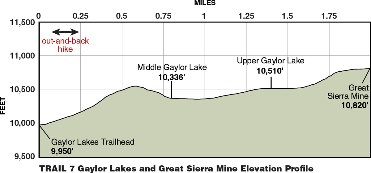
As you move west on the ridgetop, the rocks underfoot become quite purplish, a hue shared by the flowers of penstemon and lupine, which obtain their mineral requirements from these rocks. Now the trail descends steeply past clumps of whitebark pine to middle Gaylor Lake (0.8 mile) ▶2 and skirts the lake’s north shore. On the other side, the peaks of the Cathedral Range seem to be sinking into the lake, their summits barely poking above the water. For those wishing to explore this lake’s environs instead of pushing higher, a use trail encircles middle Gaylor Lake, letting you admire the shimmering waters from all aspects.

The main trail leads up the inlet stream, making a short, gradual ascent to upper Gaylor Lake (1.4 miles). ▶3 The meadows through here are strikingly lush in comparison to most Sierran landscapes because the soils derived from the metamorphic rocks provide the plants with a greater supply of nutrients and minerals, allowing a dense carpet of plants to establish. Large boulders dot the landscape—favorite perches of marmots.
Wandering along the shore of the upper lake, you cross the inlet stream, resume a steeper climb, and soon you can see a rock cabin, a century-old relic, built by a mining company that sought to tap the silver veins that run somewhere under Tioga Hill, directly north of the lake. Should you go to the cabin, you can admire the skill of the dry-rock mason who built this long-lasting house near the Sierra Crest. Farther up the hill are other works—including one dangerous hole—left by the miners, in various states of return to nature. Several other cabins are in this area, and they are all that are left of the envisioned “city” of Dana, the site of the (not so) Great Sierra Mine.


Atop Tioga Hill (2.0 miles) ▶4, which is just beyond the cabins, you have all the earlier views plus a view down into Lee Vining Canyon. A scant mile northeast of and below Tioga Hill is another “city,” Bennettville, which in the 1880s sprang up near the mouth of a tunnel being dug to exploit the silver lodes. Its founder mistakenly projected that its population would rise to 50,000, but at its heyday it did feature several dozen buildings, including a post office. From this vicinity, most folks return to the trailhead (4.0 miles), ▶5 but with map in hand, from upper Gaylor Lake, you could navigate 0.4 mile southwest to relatively close alpine lower Granite Lake, following the lake to its southern edge and then returning southeast to middle Gaylor Lake.
| ||
▶1 | 0.0 | Start at Gaylor Lakes Trailhead |
▶2 | 0.8 | Middle Gaylor Lake |
▶3 | 1.4 | Upper Gaylor Lake |
▶4 | 2.0 | Great Sierra Mine |
▶5 | 4.0 | Return to Gaylor Lakes Trailhead |
Hemlocks just above Crown Lake (see Trail 1)
 MILESTONES