
Sunrise Lakes and
Sunrise High Sierra Camp
TRAIL USE
Day Hike, Backpack, Horse
LENGTH
10.3 miles, 4–8 hours (over 1–2 days)
VERTICAL FEET
One-way: +1,800', –640'
Round-trip: ±2,440'
DIFFICULTY
TRAIL TYPE
Out-and-Back
FEATURES
Lake
Wildflowers
Great Views
Camping
Swimming
Steep
FACILITIES
Bear Boxes
Restrooms
Shuttle Stop
The terrain passed on this quite short hike is varied and scenic, with two superb camping possibilities, the upper Sunrise Lake and Sunrise High Sierra Camp. Those at the latter are rewarded with a beautiful sunrise—the reason the camp is situated where it is. Hikers pursuing this route must, however, be prepared for a steep climb as you rise above the Tenaya Creek drainage: you ascend 1,000 feet in just 1.1 miles, an unusually sharp climb for a Sierra trail. You can’t avoid this climb, but if you wish to make it a shorter day, the hike to upper Sunrise Lake is just 3.55 miles each way.
Permits
Overnight visitors require a wilderness permit for the Sunrise Lakes Trailhead, issued by Yosemite National Park. Pick up your permit at the Tuolumne Meadows Wilderness Center, located in the parking lot a short way down Tuolumne Meadows Lodge Road or at another of the Yosemite permit-issuing stations (see “Permits”).
Maps
This trail is covered by the Tom Harrison Tuolumne Meadows map (1:42,240 scale), the National Geographic Trails Illustrated #309 Yosemite SE map (1:40,000 scale), and the USGS 7.5-minute series Tenaya Lake map (1:24,000 scale).
Best Time
Because of fairly high elevations and some northerly aspects, the pass between upper Sunrise Lake and the High Sierra Camp can have snow patches into July; only in lower snow years will you want to take this route in June. Lakes are near their optimal temperatures mid-July–August, and mosquitoes have tapered by late July, making August the favorite month of many backpackers. To avoid crowds, consider a September trip, though nights will be notably cooler. You can even go in early and mid-October, though then be prepared for cool days and subfreezing nights to complement the yellow grasses and often bright blue skies.
Sunrise is the only High Sierra Camp not located by a lake or river, but what sunrises!
Finding the Trail
The trail begins on Tioga Road at the Sunrise Lakes Trailhead, a large pullout at a highway bend near Tenaya Lake’s southwest shore. It is located 30.7 miles northeast of Crane Flat and 8.7 miles southwest of the Tuolumne Meadows Campground. There are pit toilets at the trailhead, but the closest flush toilets and drinking water are located at the Tuolumne Meadows Visitor Center (to the east) or at the White Wolf Campground or Crane Flat store (to the west), so fill your water bottles before heading to the trailhead.
Trail Description
From the trailhead parking area, ▶1 take a trail that heads east, passes two small spur trails that depart to the right (south), and soon crosses the usually flowing outlet of Tenaya Lake. Just beyond this crossing you reach a trail junction. The trail left goes northeast along Tenaya Lake’s southeastern shore (0.2 mile). ▶2
You, however, veer right on a trail that heads south for an additional 0.25 mile along Tenaya Creek before turning to the southeast as the trail gently ascends in sparse forest over a little rise and drops to a ford of Mildred Lake’s outlet. Like the other streams over the next 2 miles, it can dry up in late summer or early autumn but requires a sandy wade (or wobbly log balance) in early summer. Beyond the Mildred Lake stream the trail undulates and winds generally south, passing several pocket meadows browsed by mule deer and crossing additional seasonal tributaries, the outlets of the Sunrise Lakes. At 1.4 miles, the trail then begins to climb in earnest, through a thinning cover of lodgepole pine and occasional red fir, western white pine, and mountain hemlock. As the trail rises above Tenaya Canyon, you pass several vantage points from which you can look north to the polished granite walls rising above Tenaya Creek, though you never see Tenaya Lake. To the east the canyon is bounded by Tenaya Peak; in the northwest are the cliffs of Mount Hoffmann and Tuolumne Peak.

Now on switchbacks, you see Tioga Road across the canyon and can even hear vehicles, but these annoyances are infinitesimal compared to the pleasures of polished granite expanses all around. Your route ahead is steep—few Sierra trails ascend 1,000 feet in just 1.1 miles. The trail is also, in places, annoyingly rocky, reflecting the many half-buried boulders and partially submerged slabs with which the trail construction crew had to contend. At least these switchbacks are, for the most part, mercifully shaded, and where they become steepest, requiring a great output of energy, they give back with the beauty of a fine flower display, including lupine, penstemon, paintbrush, larkspur, buttercup, and sunflowers such as aster and senecio. Finally the switchbacks end and the trail levels as it arrives at a junction on a shallow, forested saddle (2.55 miles). ▶3


Straight ahead leads to Clouds Rest and beyond (Trail 18), but you turn left and first contour east, cross a low gap, and descend north through broken forest to lower Sunrise Lake (3.0 miles). ▶4 The western shore of this lake sports a number of small campsites, the first under forest cover, the latter smaller and more open in flat patches between slabs. Steep exfoliating slabs dominate the cross-lake view, while heath species, including red mountain heather and western Labrador tea, decorate the lakeshore. Climbing from this lake, you reach a crest in several minutes, and from it you could descend cross-country an equally short distance north to more isolated, island-dotted middle Sunrise Lake. Your trail, however, veers east and gains a very noticeable 150 feet as it climbs to upper Sunrise Lake, the largest and most popular lake of the trio (3.55 miles). ▶5 Campsites are plentiful along its north shore, away from the trail and reached by crossing the lake at its outlet.


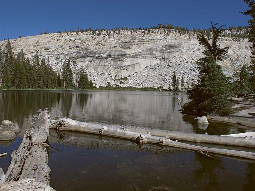
Lower Sunrise Lake
With 1.6 miles remaining to your day’s goal, you skirt the edge of the flower-filled meadow ringing the lake, diagonal up a slope, and soon find yourself in a shallow gully that you follow south across dry gravelly soils. At a broad pass you can look back to Mount Hoffmann or ahead to see the Clark Range head-on, piercing the southern sky. From the gap, which is sparsely clothed with mountain hemlocks, whitebark pines, and western white pines, you begin a shallow descent, still on decomposing granite and hopefully catching a glimpse of a Clark’s nutcracker, the gray-and-white relative of blue jays that frequents the timberline country. The grade increases and you descend south into denser cover, veer east, and then north to make a steep descent to the Sunrise backpackers’ camp, complete with a water faucet, pit toilet, food storage boxes, and ample (if crowded) campsites. From near the pit toilet, a use trail leads northeast to the Sunrise High Sierra Camp. An overnight stay at either camp gives you an inspiring sunrise over Matthes Crest and the Cathedral Range. Continuing briefly down the main trail below the campsite leads to a T-junction with the John Muir Trail, where turning right takes you to Yosemite Valley and left (north) takes you along L-shaped Long Meadow toward the Cathedral Lakes and Tuolumne Meadows (5.15 miles). ▶6 After a beautiful night’s sleep or picnic lunch, you then retrace your steps to the trailhead (10.3 miles). ▶7

Vista to Mount Florence from Sunrise High Sierra Camp
| ||
▶1 | 0.0 | Start at Sunrise Lakes Trailhead |
▶2 | 0.2 | Right at junction to Tenaya Lake perimeter trail |
▶3 | 2.55 | Left at Sunrise Lakes–Clouds Rest junction |
▶4 | 3.0 | Lower Sunrise Lake |
▶5 | 3.55 | Upper Sunrise Lake |
▶6 | 5.15 | Sunrise High Sierra Camp backpackers’ campground |
▶7 | 10.3 | Return to Sunrise Lakes Trailhead |
 MILESTONES