TRAIL 38 Yosemite Valley’s South Rim
Sentinel Dome
TRAIL USE
Day Hike,
Child-Friendly
LENGTH
2.2 miles, 1–2 hours
VERTICAL FEET
One-way: +470', –80'
Round-trip: ±550'
DIFFICULTY
TRAIL TYPE
Out-and-Back
FEATURES
Summit
Great Views
Granite Slabs
Geological Interest
FACILITIES
Bear Boxes
Restrooms
Sentinel Dome is a perfect first peak experience for a family, as well as a must-visit destination for every view seeker. While it lacks the aerial Yosemite Valley views available at the rim vista points (Dewey Point, Taft Point, and Glacier Point), its view of the Yosemite high country surpasses these other locations. For little effort you can see all the way to Yosemite’s eastern boundary.
Maps
This trail is covered by the Tom Harrison Yosemite Valley map (1:24,000 scale), the National Geographic Trails Illustrated #306 Yosemite SW map (1:40,000 scale), and the USGS Yosemite Valley map (1:24,000 scale).
Best Time
Because Sentinel Dome provides a good view of Yosemite Falls, if your goal is to see the falls churning, you should visit this viewpoint while the falls are still flowing with considerable volume, which is late May–mid-July. If the expansive views of the southern and eastern reaches of the park propelled you to this destination, then you can take the trail anytime Glacier Point Road is open and the snow has melted, usually from early May through at least late October. And of course, Vernal and Nevada Falls, off to the east, will be flowing year-round—the white stripes they delineate on the panoramic landscape simply become thinner as the year progresses.
From a signed junction along Wawona Road, drive 13.2 miles on Glacier Point Road to a parking area, on your left. This is 2.3 miles before the Glacier Point parking lot entrance. The parking lot fills early, after which cars begin lining Glacier Point Road and small pullouts up to 0.5 mile before and after the main trailhead parking. The closest water faucets are at the pullout at the Wawona Road junction, in the Bridalveil Creek Campground, and at Glacier Point.
Trail Description
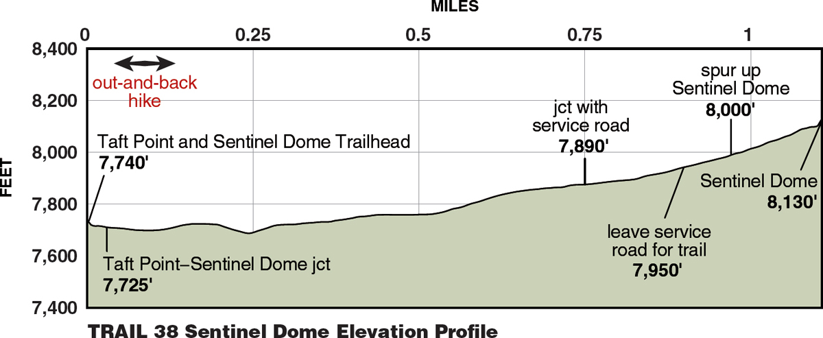
From the parking area ▶1 you descend briefly to a trail (0.03 mile), ▶2 turn right, and begin a curving descent into a shallow gully; left leads to Taft Point. The trail now traverses north, across sandy slopes and through additional gullies, before climbing more diligently on an open sandy slope, all the while your gaze fixed on Sentinel Dome, which lies straight ahead; slabs lie just beneath the surface here and only a few shrub species can scrape out a living in the pitiful soils. Atop this slope, you meet a service road (0.75 mile) ▶3 that you follow north (left). Walking through open forest cover, you soon diverge left back onto a trail (0.9 mile) ▶4 and almost immediately arrive at the northern base of the dome (0.97 mile), ▶5 where you meet a path ascending from Glacier Point. Turning left, you now climb southwest on quite safe, unexposed bedrock slopes—just watch your footing because though there is nowhere far to fall, it is remarkably easy to slip on the gravel and sand lying atop slabs of rock.
At an elevation of 8,122 feet, Sentinel Dome is the second-highest viewpoint above Yosemite Valley (1.1 miles). ▶6 Only Half Dome—a strenuous hike—is higher. Sentinel Dome was formed by the exfoliation of rock layers, rather than by glaciation. Indeed, you will find no evidence of glacial polish on Sentinel Dome’s summit, and the rock exposed here has been weathering for hundreds of thousands of years. Exfoliation is the shedding of thin layers of granite slab from the surface of the dome, and if you stare closely at the steep sides of Sentinel Dome, you can, without too much imagination, see it as a giant onion slowly being peeled apart.


Seen from the summit, El Capitan, Yosemite Falls, and Half Dome stand out as the three most prominent valley landmarks. Northwest of Half Dome are two bald features, North and Basket Domes. On the skyline above North Dome stands blocky Mount Hoffmann, the park’s geographic center, while to the east, above Mount Starr King (an unglaciated, true dome), stands the rugged crest of the Clark Range. A disc atop the summit identifies these landmarks and many others—likely fueling your desire to explore ever more of Yosemite. Note, however, that the disc atop the peak proclaiming the names of distant peaks is not 100% accurate—you cannot see Mount Ritter from the summit. In years past almost everyone who climbed Sentinel Dome expected to photograph its windswept, solitary Jeffrey pine, made famous by Ansel Adams. That tree, unfortunately, succumbed to drought in the late 1970s, but there are still gnarled, wind-weathered trees to satisfy your photographic needs. After a long summit break, retrace your steps to the car or combine this excursion with a walk to Taft Point, described as an option in Trail 37 (2.2 miles). ▶7
| ||
▶1 | 0.0 | Start at Taft Point and Sentinel Dome Trailhead |
▶2 | 0.03 | Right toward Sentinel Dome (versus Taft Point) |
▶3 | 0.75 | Left onto service road |
▶4 | 0.9 | Left back onto trail |
▶5 | 0.97 | Left on Sentinel Dome spur trail |
▶6 | 1.1 | Sentinel Dome’s summit |
▶7 | 2.2 | Return to Taft Point and Sentinel Dome Trailhead |
 MILESTONES