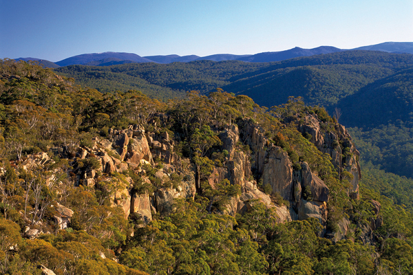

The granite slabs of Booroomba Rocks attract rock-climbers
PARK INFORMATION
Department of Environment and Sustainable Development 13 22 81 | www.environment.act.gov.au | Namadgi Visitor Centre (02) 6207 2900 | www.australianalps.environment.gov.au
SIZE
106 095 ha
LOCATION
32 km from Canberra
PERMITS
Permit required for hiking and camping in the Cotter River catchment area
ACCESS
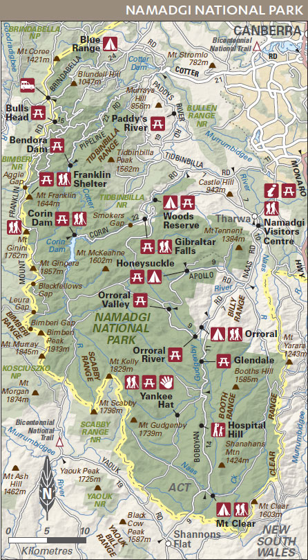
From Canberra via Tharwa then off Naas Rd (Namadgi Visitor Centre is 2 km from Tharwa); from Canberra via Tidbinbilla Rd (Tidbinbilla Nature Reserve backs onto national park)
BEST SEASON
All year; winter can be icy and cold
VISITOR INFORMATION
Canberra Connect 13 22 81
MUST SEE, MUST DO
JOIN a ranger-guided walk to learn about the park
FOLLOW the National Bicentennial Trail through majestic wilderness on foot, horse or mountain bike
INDULGE in some serious stargazing in the crystal-clear air
TRY a little trout fishing in the snow-fed streams
WALK across the flowering herbfields in summer
Rolling grassy hills unfold towards the horizon, hardy snow gums create woodlands on the subalpine slopes and higher still are alpine meadows with fragile wildflowers in season. Namadgi National Park is close to the nation’s capital, but a world away from city life.
Namadgi National Park occupies more than half the Australian Capital Territory, with the south-west section of the park joining Kosciuszko National Park. Namadgi embraces tracts of wilderness, some of the highest peaks in the country (there are seven peaks over 1600 metres), rugged walking tracks and a rich Indigenous cultural heritage.
A look at the past
Pastoralists moved into the district in the 1830s, struggling to establish themselves, with isolation and the severe weather taking their toll. The remains of fences, huts and abandoned homesteads recall those pioneering days. In the 1860s gold-seekers trekked through en route to the snowy fields at Kiandra and in the Gudgenby area parts of the hard-won trail can still be seen. From the 1960s to the 1980s, space-tracking stations operated at Honeysuckle Creek and in the Orroral Valley. The national park, which protects the Cotter River catchment, the source of Canberra’s water supply, was declared in 1984.
Aboriginal culture
Rock art, campsites and quarry sites where stone was gathered are among the many clues to the long occupation of this land by Indigenous people. It is believed their history here stretches back over 20 000 years. The name Namadgi is derived from an Aboriginal word for the ranges to the south-east of Canberra.
Natural features
Namadgi is majestic mountain country through which major rivers have gouged a path. The oldest exposed rocks here, once deep below the sea, are possibly over 440 million years old. Since then, rocks have been folded and raised high to create mountains, and rugged granite formations have emerged. This is the northern end of the Australian Alps and snow falls on the higher regions of the lovely Brindabella and wild Bimberi ranges in winter.
Native plants
Open woodland covers much of the park, with broad-leaved peppermints in the lower regions, and the twisted shapes of snow gums at higher altitudes. In sheltered aspects, particularly on the western side of the park, wet forests occur. Look for ribbon gum (manna gum or Eucalyptus viminalis) near waterways and stately alpine ash on cool, south-facing slopes. Sweeping open grasslands occupy the Orroral and Boboyan valleys, treeless flats that were largely cleared during the grazing years. The park’s bogs and fens are of special biological significance, with the moist sphagnum moss bogs an important water catchment, but also providing a home for rare species such as the endangered corroboree frog. Above the snowline, on the park’s highest peaks, are herbfields that are at their best in spring and summer, when silver snow daisies and billy buttons dust the landscape with colour.
Wildlife
Namadgi National Park is an important habitat for a wide array of animals, with more than 200 vertebrate species identified here. Of special note are threatened and rare species, including the diminutive (just 3 centimetres long) black and yellow corroboree frog, and the broad-toothed rat. More common animals are eastern grey kangaroos, wallabies, wombats and possums. The most conspicuous of the many birds are usually the brilliant crimson rosellas, pied currawongs, ravens, noisy magpies and the spotted quail-thrush.
Camping and accommodation
There is car-based camping at three locations in the park. All have barbecues, although campers are encouraged to bring a gas or fuel stove. Bookings must be made in advance and fees apply. Book well ahead for long weekends and holiday periods. Bush camping is also permitted within the park. Contact the visitor centre for details.
Things to do
BUSHWALKING One of the best ways to appreciate the park’s beauty is along the 160 kilometres of marked walking trails, and 22 signposted walks (pick up detailed notes from the visitor centre). Some walks are quite remote and weather conditions can be extreme, so register at the visitor centre or at one of the registers in the park. The main visitor centre is on Naas Road.
CROSS-COUNTRY SKIING This is possible when conditions are suitable. Always check with the visitor centre first for road and snow conditions.
FISHING Anglers will find some good fishing but check for closed seasons for trout, and restricted areas. Live bait is not permitted in the park.
FOUR-WHEEL DRIVING You will find several routes suitable for 4WDs in the northern end of the park – Mount Franklin Road as far as the access road to Bendora Dam; Two Sticks Road, which weaves its way across the top of the Brindabella Ranges to Mount Coree; Old Mill Road and Warks Road. Note that during times of bushfire danger and heavy snow, roads may be closed.
OTHER ACTIVITIES Cyclists will find several hundred kilometres of scenic trails, but must stay on fire trails or on made roads. Cycling is not permitted in Bimberi Wilderness or on walking tracks. Horse riding is permitted on fire trails east of Old Boboyan Road. Roads provide access to various aspects of the park, but some roads are narrow and slippery when wet. The park’s clean, clear air makes for some spectacular nighttime skies so expect to do some stargazing. Take advantage of the informative ranger-guided walking tours (ask at the visitor centre for details).
ROCK-CLIMBING Booroomba Rocks is a good area for rockclimbing enthusiasts.
