PARK INFORMATION
NSWNPWS 1300 361 967 NPWS Central Coast (02) 4320 4200
SIZE
3970 ha
VISITOR INFORMATION
Gosford 1300 132 975 www.cctourism.com.au
LOCATION AND ACCESS
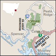
55 km north of Sydney via F3 Sydney–Newcastle Fwy then turn off at Mt White or Calga; access to the Ironbark picnic area is via Ironbark Rd, Mangrove Mountain
CAMPING
No camping

Popran National Park, 65 kilometres north of Sydney, has five sections, providing a corridor for wildlife between Brisbane Water and Dharug national parks. The environment is one of sandstone cliffs and gullies, with a stretch of Hawkesbury River foreshore and a web of freshwater tributaries. The park is relatively remote and the many rock shelters, rock engravings and shell middens testify to long Aboriginal occupation. More than 450 plant species have been identified, from impressive rainforest trees to wildflowers in drier areas. Sixteen threatened animal species in the park include the spotted-tailed quoll, brush-tailed phascogale and yellow-bellied glider.
For bushwalkers the Mount Olive Track (6 km return, 2 hours, medium difficulty) winds through dry open woodland, past Aboriginal engravings and impressive views over Glenworth Valley. Watch for nectar-seeking honeyeaters and noisy yellow-tailed and glossy black-cockatoos swooping through the trees. The 248 Track (8 km one way, 2 hours, medium difficulty) also passes Aboriginal engravings and has splendid views of the Hawkesbury River and Ironbark Creek. A network of fire trails in the Mount White vicinity provides walking routes for more experienced bushwalkers (carry topographic maps and compass), with trails leading to the rusting hull of HMAS Parramatta on the southern shores of the park.
Mountain-bike riding and horse riding (in the northern part of Popran) are other activities. Visitors can explore the edges of the park by boat, weaving past mangroves and sandstone cliffs, and fishing is permitted. It is possible to swim in Hominy Creek near Mount Olive.