Chapter Eight
Bridging the Prairies: The Railway Bridges
While the railway companies building across the prairie provinces were spared the unrelenting muskeg of northern Ontario and the death-defying gorges of the western mountains, they did encounter some of Canada’s most challenging bridge crossings. The CPR, of course, was the first to cross the vast plains and it encountered relatively few crossings west of Winnipeg. Its first bridge structures were timber trestles, easily accommodating the earliest trains, which were relatively short and the engines light.
The earliest type of bridge was known as the Howe truss bridge, a design created by William Howe as early as 1840. The earliest bridges used either the truss or the timber pile technique, and almost all were constructed of wood. But as the wood supply dwindled, and trains became heavier, steel deck plate girders replaced wood as the material of choice, while the supports were usually of poured concrete. Many of the prairies bridges are now designated as heritage properties. Indeed, the Province of Saskatchewan has completed studies on fifteen potential heritage railway bridges.
A relatively short bridge at Boharm, Saskatchewan, for example, while only six metres long, was built in 1907 and is a very early example of a steel I-beam bridge. The 1917 bridge at Kamsack, Saskatchewan, while only fifty metres long, is an early example of a through truss bridge. A 110-metre timber bridge still crosses the Cutknife river near Gallivan.
One of the CPR’s earliest bridges was built in 1893, and it crosses the Souris River between Pasqua and North Portal. At only fifty metres long, it is one of the Prairies’ oldest bridges. Other smaller heritage spans include bridges in Regina, Tantallon, and Swift Current. It is, however, the massive bridges that inspire the most awe, resembling delicate spiders’ webs, high above the wide valleys, but sturdy enough to support the heaviest of freight trains.
In Saskatchewan alone, more than sixty railway bridges exceed two hundred metres in length. In fact, that province can count more than 1,900 railway bridges.[11]
Alberta
Edmonton’s High Level Bridge
Now one of Edmonton’s iconic landmarks, the famous High Level Bridge offers passage for both rail and road traffic. At nearly 780 metres long and soaring forty-eight metres above the waters of the North Saskatchewan River, it is said to rank among the four greatest trestles constructed during the early days of the CPR. From 1913 until 1989, using the upper deck, some twenty metres above the lower deck, CPR trains regularly crossed the bridge. In fact, three sets of tracks crossed the bridge, with the centre track for the CPR trains and the two outer tracks for the Edmonton streetcars.
Unlike usual, the streetcars would travel on the left track rather than the right. Should the streetcar have become disabled while stranded precariously above the river, passengers would thereby be able to disembark from the doors on the right hand side of the streetcar and onto the centre of the bridge.
Streetcar service ended in September 1951, while the CPR ceased using the bridge in 1995. Shortly after that, the Edmonton Radial Railway Society (ERRS) began to install poles and overhead wires and in 1997 inaugurated a tour tram over the bridge. After operating a restored Japanese streetcar and a German streetcar, in 2011 the ERRS brought back into operation Edmonton Streetcar #3, restored to its original 1912 condition. The ERRS also operates a small museum in the Streetcar Barn in Strathcona, as well as a fleet in Fort Edmonton Park, where its workshops are located.
Edmonton’s Low Level Bridge
Now used for vehicles only, this structure was built by the CNo in order to link South Edmonton or Strathcona with Edmonton proper by rail. It opened in 1902 with a length of 212 metres on three steel truss spans. The tracks were gone by 1948.
The Beverley Bridge, Edmonton
Travellers entering Edmonton from the east on the northern Trans-Canada Highway will be impressed by the railway bridge over the North Saskatchewan a short distance to their north. Built by the GTP to bring their express Winnipeg to Edmonton trains over the river, it opened in 1908. With a length of over five hundred metres it rose only twelve metres above the river. Workers travelling between the communities of Clover Bar and Beverley would walk across the bridge, using the intermittent water barrels beside the tracks should a train approach. While it was originally constructed to accommodate vehicles as well, today it carries only trains and is the CN’s main line as well as the route used by VIA Rail.
The Mill Creek Bridge, Edmonton
Although it is neither grand nor distinctive, the all-wooden Mill Creek trestle represents the historic route of the Edmonton, Yukon and Pacific Railway, which was chartered in 1902 in order to finally link Edmonton with Strathcona, which were on opposite sides of the North Saskatchewan River. Despite protests from Edmonton, the CPR had refused to build a connection over the river and into Edmonton from its terminus in Strathcona. The EY&P was chartered to correct that by crossing the new Low Level bridge, which had been built by the government. While the Low Level Bridge represented the river crossing itself, the Mill Creek trestle represents a little-altered example of one the prairie’s oldest wooden trestles. Today it forms part of a trailway that follows the railway roadbed through the Mill Creek Ravine.
Red Deer’s CPR Bridge
Now part of the popular Waskasoo Trail system in Red Deer Alberta, the CPR’s bridge over the Red Deer River is a landmark located in this one-time railway divisional town. The steel truss bridge was built in 1908 in anticipation of the Alberta Central Railway completing a line from Coal Banks to Rocky Mountain House. However, funding fell short and the line was taken over by the CPR in 1911, and it established a divisional point in the community. Built as a double span steel truss bridge, it also displays a wooden trestle at the south end. Rail traffic continued to rumble across the bridge until 1991, when, as part of Red Deer’s downtown redevelopment, the CPR moved its track alignment west of the city centre, allowing the conversion of the bridge for pedestrian use.
Looking oddly out of place today, a concrete pillar stands beside Taylor Drive in Red Deer. A plaque beside it recounts that it is all that remains of a bridge built by the Alberta Central Railway in 1911 to cross the CPR tracks. When the CPR assumed control of the ACR, it decided to no longer use this bridge, and the structure was later removed. Taylor Drive itself occupies the former rail bed of the CPR, where, until the late 1990s, when the tracks were removed to construct Taylor Drive, a second pillar also stood.
The Mintlaw Bridge, Red Deer
Once the largest bridge in Alberta, the Mintlaw bridge is located on the abandoned CPR line south of Red Deer. The Alberta Central Railway began construction in 1910 but was bankrupt before it could complete the structure. The CPR took over the line and finished the bridge in 1912. At that point, the massive bridge stretched nearly a kilometre long and rose thirty metres above the river, its spans resting on fifteen piers. Abandoned by the railway in 1981, the bridge is now owned by Red Deer County and is being considered for pedestrian use on a trail that would link Forth Junction with Sylvan Lake. The structure lies south of Red Deer, but is not easily seen from any public vantage point.
Ardley’s Trestle
Another Red Deer area bridge was that built by the GTP over the Red Deer River in 1911. It measured five hundred metres long and fifty-five metres high. At first it was a wooden trestle bridge, but when it was destroyed by flooding a few years later, the centre portion was replaced with two steel spans. After being taken out again in 1952, this time by ice, it was replaced entirely by a steel trestle. It remains in use. The structure lies east of Secondary Highway 921, although there is no public vantage point from which to easily view this mighty structure.
The Oldman Bridge, Lethbridge
One of the most historic of Canada’s railway bridges, and one of the most photographed, is the CPR’s high level trestle over the Oldman River in Lethbridge. When it was completed in 1909, it was the highest of its kind in the world and to this day remains the longest. Its twenty-two girder spans and single truss span cover a distance of more than 1.25 kilometres and rise nearly one hundred metres above the river. The engineer who designed it was John Schwitzer, who also designed the Monarch trestle to the west of Lethbridge and the famous CPR spiral tunnels in the Rocky Mountain chain.
The bridge helped to eliminate an earlier, more circuitous route by replacing twenty-two smaller bridges and thirty-seven curves. It reduced the distance between Lethbridge and Fort MacLeod by eight kilometres. More than 645 railcars were needed to ship the girders from the Canada Bridge Company in Windsor to the Oldman River valley. A special design feature was the trough girders, which would keep a train from falling off the bridge should it derail. Because of its popularity with photographers and visitors, the City of Lethbridge has created a lookout point and installed interpretive signage. Nearby are walkways and plaques describing Lethbridge’s early coal mining story. Fort Whoop-up Historic Park lies at the base of the bridge.
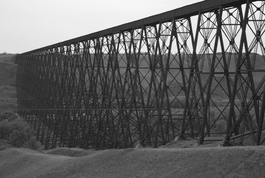
The CPR bridge over the Oldman River at Lethbridge was described as an engineering marvel and is one of the largest in North America.
The Monarch Trestle, Monarch
Around the same time as the CPR crews were bridging the Oldman River at Lethbridge, they were also hard at work west of Monarch building an almost equally impressive steel trestle over the same river. When finished in 1908, it stood more than six hundred metres long. The Monarch station, closed around the 1960s, is now a dwelling within the town. The Monarch bridge is about six kilometres west of Monarch but, unlike its counterpart in Lethbridge, twenty kilometres to the east, it lacks a viewing point.
The Bridges of the Rosebud Valley, Drumheller
The Rosebud River and Serviceberry Creek have eroded spectacular valleys, creating the layered badlands for which the Drumheller area is world famous. This valley proved to be the only viable route along which the CNo could build their line between Drumheller and Calgary. While none of the bridges along it are monumental, the countless twists and turns of the rivers meant that the railway, operating here as the Alberta Midland Railway (in reality a part of the CNo system), needed to bridge the little waterways sixty-two times within fifty kilometres. The line was built initially to haul the coal from the many coal mines near Drumheller. The ghost town of Wayne, about 10 kilometres east of Drumheller on Highway 10X, is located near the eastern section of this line, which remains in use, although it is limited today to carrying grain.

A rare surviving wooden truss bridge that once served the Atlas coal mine east of Drumheller.
East Coulee’s Wooden Bridge
East of the Rosebud River, along the Red Deer River, the rail line lies abandoned. Among the many abandoned mine sites, the historic Atlas mine, which retains many of its structures and rail cars, is now a National Historic Site. A rare wooden truss bridge crosses the Red Deer River just west of the mine. The structure built by the CNR in 1948 consists of six wooden truss spans resting on concrete piers. Tracks still sit between the wooden planks. Although the Atlas Coal Mine has become a tourist attraction, the bridge sits neglected. The much-photographed ghost town of Dorothy, with its ancient grain elevator and early churches, lies east of the Atlas mine. The mine and bridge are on Highway 10 about twenty kilometres east of Drumheller.
Rochfort Bridge, Mayerthorpe
One of North America’s longest wooden trestles, the Rochfort Bridge, near Mayerthorpe, Alberta, stretches more than eight hundred metres long across the Paddle River. After the CNo completed the bridge in 1914, farmers would herd their cattle across the structure, while pedestrians caught before an oncoming train would simply wait on one of the barrel stands located beside the tracks. Braver souls have been known to enjoy the thrill of driving their car over the mighty structure.
In 1935 soil slippage in the valley forced the pilings four metres out of line, requiring new pilings down to bedrock. In 1944 pressure from unusually severe ice floes once more forced the bridge out of line. Later, in 1956, fire damaged more than two hundred metres of the bridge’s timber supports, once again halting traffic on the CNR’s busy Edmonton to Whitecourt line. It remains in use today, although trains must limit their speed to fourteen kilometres per hour.
A lookout area on Range Road 80 south of Highway 43, a short distance east of the village of Rochfort, allows spectators to view trains crossing the mighty structure. The popularity of the trestle has influenced at least one business — the Rochfort Bridge Trading Post — to include the “Bridge Burger Challenge” on its menu.
The Sangudo trestle, another significant bridge, lies nearby on the west end of the village of Sangudo, a few kilometres to the east of Rochfort Bridge. Although smaller, it is nonetheless an impressive feat of engineering and is best viewed from Range Road 7, south of Highway 43, or from the Riverside Campground and Day Use Area in the village itself.
The Entwhistle Connection
One of western Alberta’s most spectacular gorges is that which was carved by the Pembina River following the last Ice Age. By 1908 the Grand Trunk Pacific Railway had constructed its main line up to the brink of the gorge and halted there long enough for the community on the east side of the gorge to become a busy end of steel known as Entwhistle. At sixty metres deep and 350 metres wide, the chasm proved a sufficient obstacle for the GTP, and it spent two years bridging that gaping abyss. Finally, in 1910, the trains began to cross the dizzying trestle, and the tiny mining town of Evansburg, on the opposite side, began to take shape. Still in use today, the Entwhistle trestle is one of Canada’s highest.
Blindman River Bridge, Blackfalds
In 1911 the Canada Northwestern Railway built a long wooden trestle that stretched six hundred metres across the Blindman River near the community of Blackfalds, now part of the growing Red Deer urban area. While the end portions retain their wooden piers, the central section now consists of steel girders. Because much of the old trestle was filled in, the bridge has been shortened to about two hundred metres. The CNR continues to run their freight trains over the structure.
Briggs Ravine
A rare timber trestle bridge, one of the last in the region, the Briggs bridge crosses a ravine near the Blindman River east of the vanished village of Briggs, and not far to the west of Blackfalds. It stretches more than two hundred metres across the gully. It was constructed by the Canada Northwestern Railway, now the CNR. Unfortunately, the trestle, about three kilometres north of Highway 11A, is not close to any public vantage point.
Waskatenau’s Wooden Trestle
In 1919 the St. Paul de Metis Railway, part of the CNo system, was opened between Heinsburg and Waskatenau. The aim was to serve the settlements east of Edmonton and north of the North Saskatchewan River. At Waskatenau it crossed the creek of the same name. Here, a long wooden trestle was erected and dam built to provide water for the steam locomotives. Once the railways began to switch to diesel from steam, the dam was removed, and much of the wooden trestle filled with earth. It nonetheless remains very much a heritage feature, as well as being the western terminus of the Iron Horse Trail.
East of Waskatenau, the Iron Horse Trail passes through the quiet village of Bellis, which once could claim a class-3 CNo station (added by the CNR) and yet another extensive low-level trestle. West of Waskatenau, the still active rails cross the Sturgeon River near Gibbons station on a timber trestle bridge, which is seven hundred metres long and soars thirty metres above the river.
The Beaver River Bridge, Cold Lake
Now part of the popular Iron Horse Trail, this large bridge that crosses the Beaver River south of Cold Lake Alberta consists of a single steel truss span resting on two concrete piers, with wooden frames on each end. Nearly five hundred metres long and almost sixty-five metres high, it was abandoned by the CNR in 1999.
Saskatchewan
Saskatoon’s Bridges
In 1908 the Canadian Bridge Company of Walkerville, Ontario, built for the Canadian Northern Railway a five-hundred-metre bridge over the South Saskatchewan River, a link that was vital in connecting Winnipeg with Edmonton. The company later became part of the CNR. To complete its link from Wynyard to Saskatoon, the CPR added a bridge over the river in the same year. This four-hundred-metre-long high level bridge, known as the Macdonald Bridge, today includes a foot bridge that is popular with walkers and joggers alike. Like many of the other walking bridges of the Prairies, this one is not for the vertiginously faint of heart. This structure lies along Spadina Crescent East, near the intersection of 33rd Street, where a parking lot by the river offers visitors an opportunity to view the bridge or mount the steps to cross it. The University of Saskatchewan sits on the east bank, while the main part of the city is on the west. The current CNR bridge, which has no pedestrian walkway, lies near Spadina Crescent West, some distance south of 11th Street West.
North Battleford’s Bridges
When the CNo was laying its tracks across central Saskatchewan, it opted to remain on the north side of the Battle River, thereby bypassing the older historic settlement and one-time capital of Battleford, which lay on the south bank. Here, the CNo established a divisional point and new community called North Battleford. Later, in 1912, the GTP extended a branch along the south side of the river, linking Swift Current with Battleford, and it erected a 93-span, 220-metre timber trestle over the Battle River. The structure was upgraded in 1924 and again in 1942 with two steel truss spans replacing the old timber spans. The abandoned GTP trestle south of the town beside 2nd Street South was purchased by the Town of Battleford to be incorporated into a trail system. This connects such local attractions as the historic Government House, which dates from Battleford’s role as the territorial capital, with the Fort Battle National Historic Site.
A second, longer trestle lies west of the town, where it also crosses the Battle River. Also abandoned, it is not visible from any public vantage point. A third even longer bridge lies to the north of North Battleford and was built by the CNo where it formed a junction with the tracks of the GTP at a location called Battleford Junction. A steel truss bridge more than one thousand metres long, it now carries the CNR main line across the North Saskatchewan River.
Prince Albert
One of Saskatchewan’s more important railway bridges was that built by the Canadian Northern Railway over the North Saskatchewan River in 1909, allowing the CNo to extend its main line from Winnipeg to Edmonton. It consisted of seven steel truss spans and a swinging portion that allowed steamboats to pass. Since the river crossing had until then been by cable ferry, the residents of Prince Albert grew anxious for a more permanent link. In fact, the community went so far as to subsidize the construction of a station and roundhouse if the CNo would expedite the bridge.
Then the province got into the act, calling for the bridge to accommodate vehicular traffic as well. When it opened in 1909, the bridge consisted of five Pratt steel truss spans of fifty metres each and one steel truss swing span of eighty metres. Finally, after 1918, steamers no longer plied the North Saskatchewan, and the swing span was fixed shut. Motor vehicles stopped using the railway bridge in 1960 in favour of the Diefenbaker Bridge. Trains, however, continue to use the old railway bridge
St. Louis’s GTP Bridge
This four-hundred-metre-long bridge across the South Saskatchewan River is made up of six steel trusses and was opened in 1915. For several years, local citizens and the provincial government continued to press first the GTP and then the CNR to incorporate a roadway into the bridge, but both companies repeatedly denied the request, even though the original design would in fact allow such additions. Finally, after the province threatened to plank in the bridge for cars, the CNR capitulated and in 1928 added traffic wings to the sides of the bridge. A smaller central lift span was included to allow steamboat traffic to pass beneath, although that form of transportation has long since ceased.
Until the traffic attachments were added, cars were forced to use a ferry service located about three kilometres upstream from the village. The CNR abandoned the line in 1983 and the bridge’s two traffic wings continue to carry vehicular traffic. A replacement bridge 1.5 kilometres away is scheduled for completion in 2012, when the old bridge will be closed. Efforts are under way for its preservation.
The town of St. Louis is situated on Highway 2, south of Prince Albert. A small roadside park near the south end of the bridge offers opportunities to photograph the bridge. A large information kiosk outlines the history of the region and the many ferry crossings that once operated along the river.

While the St. Louis “ghost train” no longer crosses the unusual road and rail bridge over the North Saskatchewan River, cars will continue to use it until a new bridge opens nearby.
The Fenton Bridge
In 1906, a few kilometres downstream from St. Louis, the CNo constructed a five-hundred-metre bridge across the South Saskatchewan River. Built first as a timber structure to replace washed out bridges, it was rebuilt in 1982. While the centre portion consists of a steel truss span, the two edges are made of timber pile and frame. It lies on the Hudson Bay Junction to Prince Albert section of the former CNo rail line about twelve kilometres west of the community of Birch Hills. Vehicular traffic must use a privately operated ferry to cross the river. A short side trip down a local road on the north side of the river and west of the ferry will bring the visitor within view of the mighty structure.
Meskanaw’s Wooden Trestle: Saskatchewan’s Longest
At more than four hundred metres long, the Meskanaw bridge is the longest wooden trestle bridge remaining in Saskatchewan. It lies beside the highway a short distance west of the village of the same name. The structure was built by the Canadian National Railway in 1929. Although no interpretive sign marks this major engineering feat, a short pullout on the shoulder on Highway 41 west of Melfort permits easy viewing of this daunting structure from just a few metres away.
Outlook’s Skytrail Bridge
Now one of Canada’s most stunning walking bridges, the CPR bridge in Outlook, Saskatchewan, was, at one thousand metres, the second-longest railway bridge in Canada and its piers the world’s highest. The bridge was built as part of a CPR initiative to provide a more direct link between Edmonton and Saint Paul, Minnesota. In addition to the rail crossing, the residents of the area lobbied hard for the bridge to accommodate vehicular traffic by means of a roadway beneath the tracks. But poor communication between the provincial government and the CPR caused the negotiations to collapse and the CPR built the rail-only bridge.

The wooden Meskanaw bridge is the longest such structure in Saskatchewan.
The remarkable structure consisted of eight spans, which had been shipped from the Lachine Bridge over the St. Lawrence in Montreal, each measuring eighty metres long, as well as a pair of twenty-seven-metre spans. The first trains crossed the structure in 1912 and continued to do so until 1987, when the CPR abandoned the line. In 2005 the bridge was decked in to become the Skytrail Bridge. Now part of the Trans Canada Trail system, it is Canada’s longest pedestrian bridge — and not a good idea for those with vertigo. The government later did construct a vehicle bridge to the south of the railway bridge, and now bypassed by a newer bridge, it is also a heritage structure.
Nipawin’s “Crooked” Bridge
Built in 1929, the double-decked plate girder bridge over the Saskatchewan River in Nipawin consisted of five steel truss spans resting on four concrete piers. A five-metre-wide roadway is situated on the lower deck. The bridge replaced a small cable ferry that had in turn replaced a precarious cable car, which carried travellers high above the river.
When word of the CPR’s proposed bridge became known in 1924, the area residents began to lobby for a vehicular segment to be incorporated. The original site of Nipawin was seven kilometres from where the CPR chose to locate their station, then called Ravine Bank, causing the town, as ever, to move the buildings to trackside. The bridge earned the nickname the “Crooked Bridge” due to the Y configuration required by the cars to approach it. The bridge is over six hundred metres long and consists of fifteen steel spans. A new traffic bridge opened in 1974, giving vehicles a straighter alternative. The CPR line between Nipawin and Choiceland is now operated by the Torch River Railway, a short line railway, which still uses the historic “crooked” bridge. Nipawin is on Highway 36, north of Tisdale.
The Heart’s Hill Timber Bridge
Even small bridges can carry local heritage significance, such as this small timber bridge at Heart’s Hill. It was built in 1930 when the CNR extended its branch line from Unity to Bodo in central Saskatchewan. The last structure to survive on this branch, it witnessed its last train in 1993 and then the line was abandoned. It still features its original wooden trusses, piers, timber bents, and stringer spans. Designated as a municipal heritage property in 2006, it is listed on the Saskatchewan Register of Heritage Properties and is a popular local landmark, especially among artists. It is situated northwest of Kerrobert, about thirty kilometres west of the village of Luseland.
Manitoba
Winnipeg, Bridging the Red and the Assiniboine
In a very short period of time, the forks of the Red and Assiniboine rivers became the focus of Canada’s east–west rail network. The lines of the CPR, the CNo, the GTP, and the Northern Pacific and Manitoba Railways all converged on the forks. Winnipeg boomed into what many called the Chicago of the north. To carry the tracks of these many lines across the two rivers, several bridges were constructed. In 1914 the Canadian Northern Railway built a lift bridge over the Assiniboine a short distance from its confluence with the Red. No longer in use, the lift bridge is today part of a walking trail along the Red River and leads into The Forks heritage site in Winnipeg. With its massive concrete counterbalance, it is an attraction for artists to display their works. Adjacent to it, a newer bridge still carries CN and VIA Rail traffic across the Assiniboine.
Further downstream from the Forks, both the CNR and the CPR use massive steel trestle bridges to carry their respective main line traffic, while still further downstream, an abandoned CPR swing bridge marks its once busy North Kildonan crossing with the centre span fixed into the open position. Meanwhile, upstream on the Assiniboine, a four-span steel trestle bridge, also now abandoned, until recent times carried CNR traffic to its Oak Pointe yards.
The Uno Trestle, Rivers, Manitoba
This prominent landmark of the otherwise flat landscape around the former railway divisional town of Rivers, Manitoba, crosses the Minnewashta Creek. When built by the Grand Trunk Pacific Railway in 1908, the trestle stretched nearly a kilometre and a half in length. After it took over operations of the GTP, the CNR filled in much of the trestle and replaced the wooden supports with those of steel.
In 1991 the railway closed the bridge for five days while crews converted the massive crossing from an open-deck bridge to a ballast-deck bridge that consisted of solid concrete forms into which ballast could be placed. Today, it is less than a quarter of its original length. The presence of this looming structure has given rise to the name of a local business, the Trestle Greenhouse. While the trestle remains in use, with CN trains crossing it several times a day, as well as VIA Rail’s cross-country trains, the vacant heritage station in Rivers lies neglected.
The Pas, Manitoba
After the CNo undertook construction of the Hudson Bay Railway, it halted the line on the south bank of the South Saskatchewan River and showed little interest in bridging it. When the Canadian government began completing the Hudson Bay Railway in 1913, they constructed a six-span steel truss bridge across the wide river. While it is one of that province’s longest railway bridges, it is a low structure. Its significance lies in its strategic importance in crossing a key barrier to the completion of the line. The bridge continues to carry trains to the grain port of Churchill and to the mining and First Nations communities of northern Manitoba. Rail lovers venture over it on VIA Rail’s popular Churchill train to view the polar bears.
The Port Nelson Ghost Bridge
Perhaps the most unusual of the prairie province bridges is that built at Port Nelson. In 1913 the Canadian government took over the task of completing the Hudson Bay Railway to its terminus at Port Nelson from the CNo. Tracks gradually made their way north of The Pas, reaching the Nelson River in 1914. Duncan William McLaughlin was scarcely a dozen years out of engineering at McGill University in Montreal when he became chief engineer for the construction of the Port Nelson grain terminal. Because of the shallow depth and shifting silts, the only place to construct the wharf was on an island offshore, which necessitated a lengthy bridge.
In 1915 the tenders went out for the construction of the bridge. The successful applicant was the veteran Dominion Bridge Company of Montreal. They began the job of assembling seventeen steel spans of more than thirty-five metres in length each. Throughout the short shipping seasons of 1915 and 1916, the bolts and beams began to arrive, and on August 26, 1916, the last span was hoisted into place. To further reduce the risk of ice and currents, a barge was sunk upstream to break up any ice and the bridge itself was raised higher.
Then, in the summer of 1918, after an expenditure of more than $6 million, all work at Port Nelson ground to halt. But the demand for an ocean grain port for the prairies did not. In 1927, with the western farmers howling for the completion of the railway, a British harbour engineer named Frederick Palmer was hired by the government of William Lyon Mackenzie King to compare the harbours at Port Nelson and Churchill. Harshly criticizing the choice of Port Nelson, he recommended that Churchill become the new grain port. The location would create a longer route but would provide a safer harbour.
In September 1929, the first grain was shipped from Churchill, and Port Nelson settled into obscurity as a ghost town. Ruins of buildings litter the grounds, a beached dredger lies on the shores of the island, but the most prominent ruin of all is the sturdy seventeen-span railway trestle, so solidly built that a train could cross it yet today. Few have visited this remote site, the only ways in being by boat or float plane.[12]