VENTURA HIGHWAY
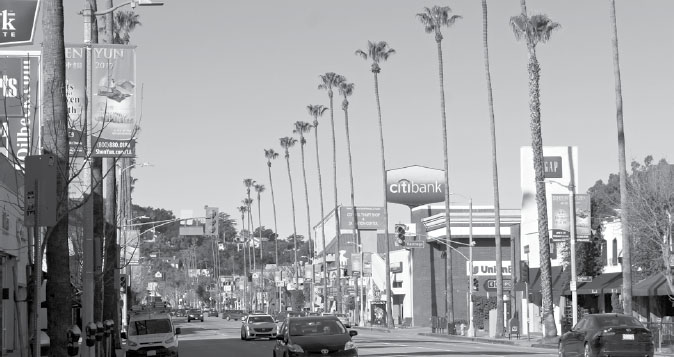
A view of Ventura Boulevard, old U.S. 101, lined with palm trees in Studio City.
There’s something about this section of the highway that lends itself to vibrant memories and vivid imagery. It’s even found its way into our musical folklore.
In Tom Petty’s “Free Fallin’” from 1989, the old highway alignment—today’s Ventura Boulevard—was a hangout for vampires. Not real vampires, but the shadowy figures who congregate off the sidewalks along the busy road.
The Everly Brothers recorded a song called “Ventura Boulevard” in 1968, and four years later, the band America released a song called “Ventura Highway” based on guitarist-vocalist Dewey Bunnell’s reminiscence of a trip down the road interrupted by a flat tire. He and his brother waited there as their father changed the tire, feeling the sun on their faces and gazing at cloud formations that reminded him of alligator lizards. The childhood scene became the inspiration for the song.
My personal memories of this section of road are just as vivid. I spent six years of my childhood in Woodland Hills, a slice of suburbia where we lived sandwiched in between then-Dodgers outfielder Bill Buckner on one side and Shelly Cohen, who served as the assistant music director for The Tonight Show, on the other. It was on Ventura Boulevard that, at the age of nine, I was introduced to my favorite Mexican restaurant, El Torito, which has since become a massive chain. Unfortunately, that location’s no longer there. But Corbin Bowl, just up the road in Tarzana, is still open. It was there that I bowled my first game at about the same age, racking up the fantastic score of 81. Built in 1959, it survived the Northridge quake of 1994 and has been used as a set for TV shows such as Moonlighting and Quincy.
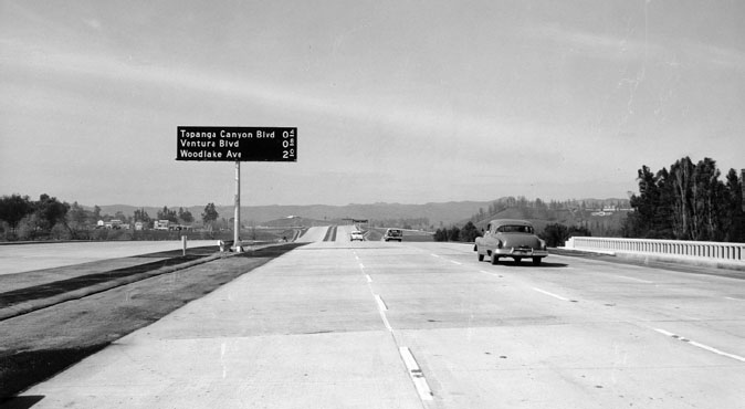
The Ventura Freeway, then called the Calabasas Freeway along this stretch, replaced Ventura Boulevard as U.S. 101. Here, it’s seen in 1958. Note that fractions of a mile are given in tenths, rather than halves and quarters. © California Department of Transportation, all rights reserved. Used with permission.
Ventura Boulevard was the artery that kept the lifeblood pumping across the San Fernando Valley—and inspiration for Frank and Moon Zappa’s song “Valley Girl,” where it’s linked with “bitchin’ clothes.” It’s the world’s longest roadway of contiguous businesses, running some 20 miles from Calabasas at its west end to Studio City, where it morphs into Cahuenga Boulevard.
It served as the alignment for U.S. 101 through the San Fernando Valley until 1956, when construction began on the new Ventura Freeway just to the north.
It’s a funny thing about the Ventura Freeway: It’s still technically U.S. 101 north and south, even though it actually runs east and west. (This was enough even to confuse the signposters, who set up signs bearing the words “east” and “west” in some San Fernando Valley locales, but “north” and “south” in others.)
Another oddity: At the so-called Hollywood Split, the interchange where the 101 morphs from the Hollywood Freeway into the Ventura Freeway—or vice versa—the Hollywood Freeway continues northward as State Route 170, while the Ventura Freeway keeps right on going eastward as State Route 134.
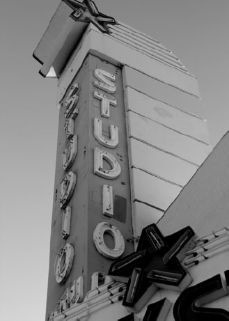
The Studio City Theatre on Ventura Boulevard was transformed into a bookstore.
PICTURES IN MOTION
Lights, camera, action. The first light—traffic light, that is—in the San Fernando Valley flashed red at the corner of Ventura and Lankershim Boulevards in a place called Studio City.
The motion picture industry was coming into its own in the second decade of the 20th century, but Hollywood didn’t spill over the hill into the San Fernando Valley until 1927—a year after Ventura Boulevard became U.S. 101. It was in the summer of that year that Mark Sennett announced plans to construct a studio on 500 acres, which would include a five-story office building on the highway at Radford Street.
The $20 million development was to front Ventura Boulevard for a full mile, and it would include an administration building, two dressing buildings, and “two immense stages,” with plans for two more stages to be built later, The Van Nuys News reported. The newspaper hailed it as “one of the greatest single development projects ever launched in the history of the San Joaquin Valley.” Other stucco buildings planned for the site would house a machine shop, cutting and projection rooms, film vault, and wardrobe and property rooms.
Sennett’s studio wasn’t the only one eyeing the site. Three other film production companies, including MGM, were poised to open studios in the new district.
The highway itself would be widened to accommodate the increased traffic, and the Pacific Electric trolley company planned to extend its service with a new line.
Before it was Studio City, the area where the highway bends southward from the valley toward Los Angeles was known as Laurelwood, an area bisected on the north-south grid by the similarly named Laurel Canyon Boulevard. In the second decade of the 20th century, Laurel Canyon was already becoming a haven for film players such as Tom Mix and Clara “It Girl” Bow, along with famed escape artist Harry Houdini, who took refuge in this scenic hideaway nestled in the Hollywood hills. (Errol Flynn had a large mansion of his own north of Houdini’s, which burned down in 1958. Tales arose that the rest of the estate was haunted.)
But earthmovers and pavers didn’t connect plush Laurel Canyon Boulevard all the way across the mountains—connecting Hollywood to the San Fernando Valley—until the 1940s. It was Studio City that first brought the film industry across the Santa Monica Mountains in a big way.
JUNGLE LOVE
West of Studio City on the 101 lies Tarzana, a name that sound like it was lifted out of Edgar Rice Burroughs’s famous stories—because it was.
Burroughs used some of the fortune he’d made writing his Tarzan stories to buy a 540-acre estate in 1919. Before he purchased the land in a rural area informally known as Runnymede, it had belonged Los Angeles Times publisher Harrison Gray Otis, who had christened it Mil Flores. Burroughs bought the estate for $125,000 after Otis died and renamed it Tarzana. It wasn’t exactly a jungle, but the author did buy animals to raise and breed on the ranch: cows, chickens, draft horses, and Angora goats, among others.
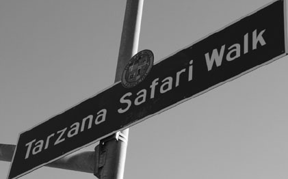
Tarzana Safari Walk pays tribute to the city’s namesake, Edgar Rice Burroughs’s fictional ape-man, Tarzan.
The centerpiece of the rancho was a 4,500-squarefoot Spanish-style mansion, which was also the social center of the rural area that surrounded it. Every week, Burroughs would invite his neighbors to the theater underneath the servants’ quarters to watch a free movie. As many as 200 people would show up to pack the place on any given Friday.
By 1922, though, he had grown weary of being lord of all he surveyed and decided to subdivide the land, offering tracts for sale in a nascent community that took its name from the estate—and the fictional hero. His description of it made this new vision for Tarzana sound something like a proto-hippie commune.
He advertised it as “an artistic colony on high class residential acres,” open to all “who expressed artistic desires through the medium of pictures, flowers or vegetables, furniture, drugs, plumbing, poetry or the screen—but artists, each in his own field, and each a lover of the beautiful. The mere desire to join this art colony will not in itself be sufficient unless you have the artistic urge.”
Unfortunately for Burroughs, such an art colony was probably too far ahead of its flower-power time. He wasn’t able to sell many of the lots, so he simplified his pitch with a newspaper ad that read simply, “Tarzan of the Apes to Sell Lots in Tarzana.” A few more lots sold, but not enough for Burroughs, who decided to move out of his mansion and converted it into the clubhouse at a country club he started.
In 1926, he moved into a smaller cottage along Ventura Boulevard—Old 101—and two years later, members of the nascent community decided to honor its founder by adopting the name he’d used for the rancho: Tarzana. Burroughs eventually left the Valley completely; he and his first wife divorced in 1934, and he remarried a year later, resettling with his new bride in Santa Monica. A few years later, he sold the land to developers who could achieve what he’d failed to accomplish: find buyers for subdivided plots from the old rancho. He got just $30,000 for it, less than a quarter of what he’d originally paid, the bottom having dropped out of the real estate market during the Depression.
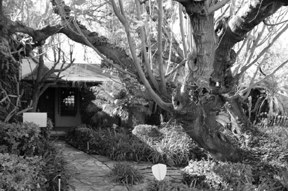
This walnut tree was planted as a memorial to author Edgar Rice Burroughs in front of his office on Ventura Boulevard (old U.S. 101).
The community, meanwhile, took a long time to fully embrace its identity: In 1936, a total of 300 residents signed a petition to change the name to Otono, with one of the people who argued for the change lamenting that the post office was likely to be annexed to Reseda, Van Nuys, or Canoga Park unless a better name were found.
“Edgar Rice Burroughs, who lives in Santa Monica, is the heaviest patron of the Tarzana Post Office,” Droege said. “His books published in the east are forwarded here so they can be mailed out with a Tarzana postmark. And I can’t even find a Tarzana library.”
Another name considered at the time was Walnut Hills. The chamber of commerce, though, opposed the idea, and it ended up dying—for the time being, anyway. In 1949, a year before Burroughs’s death, residents launched another drive to adopt a new, less kitschysounding name. Options on the table included West Encino, South Hills, and Southridge. Burroughs, who once remarked that “City of Tarzana” sounded like the name of a steamboat, gave his blessing to the idea of a name change, but again, the idea failed to take hold.
Tarzana stayed Tarzana.
Burroughs came home himself—posthumously—when his ashes were scattered in Tarzana under a walnut tree on Ventura Boulevard, outside his old office.
Still, it wasn’t until 1987 that the community really got into the spirit of things, holding its first Tarzan Movie Festival with showings of two 1970 films, Tarzan’s Deadly Silence and Tarzan’s Jungle Rebellion. The event featured T-shirts, posters, a costume contest, and free comic books printed in languages from Swedish to Portuguese. Eleven years later, Tarzana renamed its business district “Safari Walk.” No matter how hard it tried, it couldn’t escape the shadow of the lord of the jungle. So, in the end, Tarzana finally submitted to his rule.
GIRARD’S TURKEY
One of the busiest on- and off-ramp exchanges on the modern freeway is at Topanga Canyon Boulevard, a major crossroads since before the route was a freeway or even a federal highway.
Before Topanga Canyon was even paved, it was a natural pass through the Santa Monica Mountains connecting the western San Fernando Valley with the coast. A huckster from Kentucky named Victor Girard Kleinberger knew an opportunity when he saw it and promptly bought up 3,000 acres of land in the vicinity with the intent of marketing it as an exotic new settlement with a Turkish theme.
Kleinberger dropped his last name in an act he touted as repudiating his German heritage during World War I. He built a series of structures near the then-rural intersection to resemble a Turkish city—complete with fountains, light standards, domes, and minarets. Everyone else was building in the Spanish Mission style, and he wanted something that would stand out. Besides, he had an affinity for southwest Asia, having previously worked as a door-to-door salesman hawking knockoff Persian rugs. His favored tactic: rolling the rugs out across a homeowner’s doorstep to keep the door from being slammed in his face.
He announced his new development with great fanfare in 1923.
Some of the buildings were nothing more than facades, meant to create the illusion of a thriving business district, something Girard hoped to create: a kind of “half-build it and they will come” approach. A huge sign adorned with a pointing index finger advertised Topanga Canyon as a “scenic mountain drive” across a state highway with an easy grade. In typical P. T. Barnum fashion, Girard stretched the truth just a tad by boasting that ocean breezes would cool future residents—even though the ocean itself was some 13 miles away. But perhaps the biggest attractions were the trees. The valley back then was an open plain of pastureland, so Girard decided to spruce things up by planting more than 120,000 trees across his land: eucalyptus (later a staple along western highways), acacia, pine, sycamore, and pepper trees.
Girard subdivided the land to maximize his potential profits by creating some 6,800 lots that were just 25 feet across at a time when land was still plentiful and the typical parcel was measured in acres, not feet. Then he launched a campaign that included newspaper ads, along with pamphlets placed in hotels and train depots to catch the interested traveler’s eye. Among his promotional innovations was the so-called “sucker bus,” a tactic used widely in time-share promotions decades later: He offered a seat on the bus, a free lunch, and a tour of the area—highlighted, of course, by a visit to his nascent development. A ticket for one of these tours could be redeemed for a free 80-mile trip to the town of Girard: “Ride in comfortable busses and have lunch with us. No obligation.”
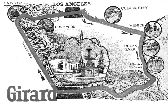
This vintage ad points the way to Girard, a development in the western San Fernando Valley, later renamed Woodland Hills.
Named, naturally, Girard.
Girard even started his own newspaper to promote the development, then made it more attractive by spending some $300,000 on new streets and adding features such as stables and a golf course. Meanwhile, he pushed for a new highway across the Santa Monica Mountains, which eventually came to fruition as Mulholland Drive.
How did Girard pay for all this?
By taking out loans that he’d never have to repay. Instead, he put a lien on every lot he sold that left the buyers on the hook for the money. Undeveloped lots could be purchased for $500, but Girard’s sales staff would accept almost anything offered as a down payment to get the buyer on the hook, sometimes selling the same piece of property to multiple buyers.
Girard built homes in the development, too. Or, rather, cabins made with log siding and placed on wooden foundations built directly on bare earth. About 100 of them were built, starting at just 500 square feet and without any running water or electricity. A few still remain in an area known as Spaghetti Canyon in honor of its winding streets.
The community, like so many other high-flying speculations, came crashing down to earth with the stock market in 1929, and many of the residents—faced with those nasty liens they couldn’t pay on top of their regular bills—simply abandoned the place. Girard found himself saddled with a slew of lawsuits and more than 1,300 acres of land he had been unable to sell, so he folded his Boulevard Land Company.
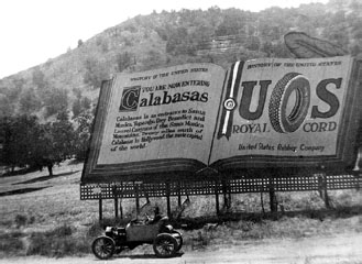
A 1917 billboard touts Calabasas as “an entrance to Santa Monica.” Public domain.
By 1932, the community that bore Girard’s name had dwindled to 75 families, but that wasn’t the end of the story.
Unlike the development he’d built, the trees he’d planted to attract prospective buyers flourished—and eventually began to attract a new generation of residents to the area. In 1941, mindful of the stigma associated with Girard, they decided to erase his name from the map and replace it with a more elegant and descriptive moniker.
Woodland Hills.
VENTURA BOULEVARD AND BEYOND
Old 101 was a maze of surface streets in Los Angeles and Orange County before the dawn of the freeway era, but that wasn’t the case in the San Fernando Valley.
Indeed, following the Old 101 is a relatively simple matter once you cross the Santa Monica Mountains: Just stay on Ventura Boulevard for 20 miles until you reach the west end of the San Fernando Valley at Mulholland Drive. Then cross under the freeway and keep going on Calabasas Road. You’ll head through Old Town Calabasas and past the Sagebrush Cantina. Built in the early part of the 20th century, it was once the Oak Garage and general store that sold RC Cola and Associated Gas. An El Camino Real bell stood in the parking lot underneath the 12-foot-tall oak tree that gave the garage its name, celebrated locally as the “hanging tree.”
There’s no solid evidence anyone was actually hanged there (although the town jail stood where the parking lot is until the early 20th century), but a noose was hung from the tree around 1970 for the fun of it. Unfortunately, the tree—which had been dead for some time—toppled over during a storm a quarter century later. The town, however, not to be so easily deprived of its heritage, saved the pieces of the old oak and reassembled it.
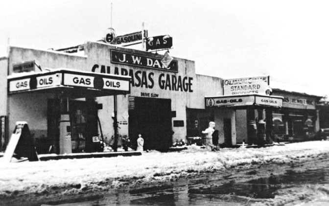
That doesn’t mean the place didn’t see its share of Wild West mischief. A 1921 headline in the Oxnard Press-Courier proclaimed, “Calabasas Garage Is Looted by Bandit Gang.” The bandits made “a complete robbery of the building,” blowing open the safe and taking a hefty sum of cash in addition to making off with tires, motor oil, and other merchandise.
The garage had been in business at least 4 years by that time at the westernmost outpost in the San Fernando Valley.
From Calabasas, the Old 101 continued west into the hills, crossing back under the highway on Las Virgenes Road before heading west again as Agoura Road and into Thousand Oaks as Thousand Oaks Boulevard. There it disappeared beneath the modern freeway before resurfacing again in Ventura as Main Street and Thompson Boulevard.
One of the most challenging obstacles along the way was a steep descent (or climb, going the other direction) between Thousand Oaks and Camarillo called the Conejo Grade. The modern freeway negotiates a steep 7 percent grade that’s a fairly straight downhill run into Camarillo—at least compared to its predecessors.
A paved two-lane state road, built in 1914, replaced an earlier gravel passage down the mountain, but even that was a winding, switchback-laden course with no fewer than 49 twists and turns. Plenty of motorists were seriously injured or even killed in the early part of the century when their cars skidded off the precipitous incline and tumbled down the hill. Among them was a rancher named Ernest Thompson, a passenger in a car driven by one Frank Wadleigh. While traversing “one of the most dangerous pieces of mountain road in the state, the car suddenly skidded and went 200 feet down the mountainside, turning several somersaults and instantly crushing the life out of” Thompson. Wadleigh, amazingly, made it through with no more than a few bruises, according to an account in the Bakersfield Californian.
The Calabasas Garage on old U.S. 101 is seen in 1932. Calabasas Historical Society.
That first state road, later designated a portion of U.S. 101, was replaced in 1937 by a three-lane highway (one lane in each direction, plus a central passing or “suicide” lane) and finally, in 1958, by the modern freeway.