THE PACIFIC COAST HIGHWAY
Travelers can be forgiven for confusing State Route 1 with U.S. 101. For decades, lengthy segments of the road that’s now called SR1 in the Los Angeles area were numbered as the 101 Alternate along the coast. This was before the San Diego Freeway (Interstate 405) was built and the state took over the route from the federal government.
Other sections, mostly where a single road is sandwiched between the Pacific and the coastal mountain ranges, remain signed as both State Route 1 and U.S. 101.
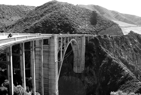
Much has been written about the Pacific Coast Highway—perhaps even more than about El Camino Real—probably because SR1 along the Central Coast is one of the most scenic drives you’ll find anywhere. The Bixby Creek Bridge, with its majestic arch set against a backdrop of green hills on one flank and blue Pacific on the other, is one of the most photographed spans in California. The Piedras Blancas Light Station, Hearst Castle, Morro Rock, and the redwoods of Big Sur are among the sights you’ll see along the stretch of winding road that’s undoubtedly the “scenic route.” In fact, it’s officially designated as a state scenic highway.
By contrast, it parallels a segment of 101 about 30 miles inland that runs through the Salinas Valley, a straight shot at 65 mph across flatlands flanked by agricultural fields and often-brown hillsides.
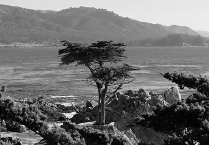
This iconic, solitary cypress tree stands off the coast of central California, not far from State Route 1, on 17-Mile Drive in Pebble Beach.
U.S. 101 is the older of the two roads here, which makes sense when you consider how challenging it must have been to build a highway across the isolated, craggy cliffs that hug this section of coastline. Despite engineering that only gets better with new innovations, Mother Nature still plays havoc with the coast road, sending down mudslides and undercutting segments of the highway during heavy storms and El Niño-spawned rainy seasons. As I write this, a segment of State Route 1 to the north of me, between Ragged Point and Big Sur, remains washed out and impassible thanks to a recent mudslide.
It’s no wonder that southbound traffic couldn’t get any farther than Bixby Creek before the iconic bridge was built across it in 1932. And the town where I now live, Cambria, marked the end of the road for northbound travelers until as late as 1937 (there’s even a book on the history of Cambria titled Where the Highway Ends).
You can still see the many sections of the first concrete road heading north from San Luis Obispo to Morro Bay. Much of it lies neglected on private property, with weeds sprouting up through cracks in the pavement. It runs north from the Cuesta College campus as Tomasini Road and crosses over the modern highway to its north side as Adobe Road, neither of which is accessible to the public. It crosses over again to the south side as Quintana Road just before you get to Morro Bay, and you can follow it here into that city for about two miles before continuing north on Main Street—another section of the old highway—to the point where it ends at the north side of town.
The stretch of highway from San Luis Obispo through Morro Bay, covering roughly 20 miles, was described as “newly paved” in a news article that appeared in the summer of 1925, and it wasn’t long before the road would stretch farther than that.
A bond issue approved by the public in 1919 dedicated $1.5 million to completing the highway between Monterey and San Simeon, but it took nearly two decades for those plans to reach fruition. Inmates from San Quentin State Prison were enlisted to do much of the work—their reward being 35 cents a day and reduced prison sentences—and convict construction camps were set up along the course plotted for the road.
It wasn’t until 1926 that workers began paving the section between Morro Bay and Cambria, and although that segment was completed by the summer of 1928, you had to settle for oiled gravel and dirt beyond that. Then, about eight miles north of San Simeon, you’d have to turn around and go back the way you came, because the road ended there, with one of those convict camps blocking the way.
But the biggest challenge was farther north, where steeper cliffs that plunged at impossible angles into the ocean below created daunting obstacles to highway builders. They had to bring supplies in by boat and lift them up via steam-powered engines to where the road was being built. The problem wasn’t a new one. Charles Bixby, for whom the creek was named, owned the land around it and had asked Monterey County to build a road—only to be told that “no one would want to live there.” He had to ferry goods in and have them hoisted up from ships anchored just offshore.
In the end, Bixby did manage to build a wagon trail from his ranch to Carmel that included 23 bridges but still had to be closed every winter. He built his road 11 miles inland to avoid the canyon Bixby Creek had carved between the mountains along the coast, but the builders of the new road decided to tackle the coastline head-on. They realized they’d need to carve an 890-foot tunnel to make the inland route work for them, and ultimately decided that, despite its challenges, a route directly along the coast was safer.
Quintana Road near Morro Bay once served as a section of State Route 1.
The Bixby Bridge, which opened in 1932, is perhaps the most recognizable feature of Highway 1 between San Luis Obispo and Monterey.
Besides, the view was stunning.
As the project got under way, free men set up their own camps to build the road, along with those of the convicts. But despite the formidable manpower, progress on the road was anything but steady, with stormy weather producing the same sort of rockslides and mudslides that plague the road today. With the road still being built, one of these could damage or destroy equipment and put the workers all the way back to square one.
Once a boulder fell on a steam shovel, destroying the controls, just moments after the operator stepped away. In another case, earth gave way underneath a shovel, which somehow remained suspended 300 feet above the ocean, with just a few inches of soil holding it in place and the operator continuing to work without realizing anything was amiss.
An account in the WPA to California, printed in 1939, recalled a particularly stormy winter night when slides had blocked the road: “The word spread that the wife of a man in the freeman’s camp, about to give birth to a child, needed a doctor; of their own free will, men from both (work) camps poured out to work in the rain and pitch darkness, blasting open with dynamite a road to the community hospital.”
As part of the project, more than 30 bridges needed to be built, the first of which was a timber span 19 miles north of San Simeon at Salmon Creek, which opened in 1928. The most impressive, of course, was the Bixby Creek Bridge, about 13 miles south of Carmel, which cost nearly $200,000 to build and was the longest concrete arch span in California’s highway system at 716 feet. Concrete arch spans were also built across Garapata, Granite, Malpaso, Rocky, and Wildcat Creeks, with the Rocky Creek span carrying cars 150 feet above the waterway for a distance of nearly 500 feet.
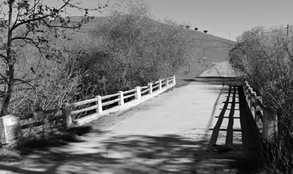
This old bridge across Villa Creek lay on a section of old Highway 1 that was bypassed; the road used by the bridge now leads to a dead end a few hundred yards to the south.
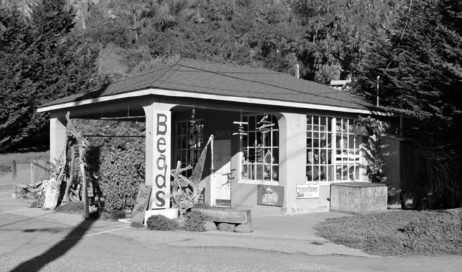
This pink bead shop at the south end of Cambria was once a fuel stop for motorists, back when Main Street through town was also Highway 1.
Convicts from camps in the northern and southern construction zones met in the middle in 1934, but more work still needed to be done, and the road wasn’t officially opened to the public until 1937.
Even though the section of the road between San Luis Obispo and Big Sur is largely rural, a few bypasses were built over the years. A new freeway replaced the Quintana Road-Main Street route in Morro Bay, and another section of freeway bypassed the old route through Cayucos, Ocean Avenue, in the 1960s. The older broad, two-lane thoroughfare passes a number of down-town buildings that look to predate the bypass, and the Borradori Garage at the north end of town dates to the earliest years of the highway. Built in 1932, it still stands at 455 Ocean Avenue.
To the north of Cayucos, just off Villa Creek Road, there’s a bridge over the creek that’s part of the old alignment, and farther north still lies Old Creamery Road in the village of Harmony. Once a dairy center and later a funky artists’ colony, Harmony—perpetual population 18—now is home to a few businesses that include a glass-blowing shop and winery. The short strip of the old route that passes through it disappears onto private land behind a locked gate at the north end of the hamlet. If you look carefully, you can still see portions of that old road, although it’s largely overgrown now. Another small bridge off to the right of the highway, just before you get to the junction of State Route 46, appears to have been part of that older road.
Cambria was bypassed, too, by the current highway in 1965, but vestiges of the old road remain. An old alignment there includes the south end of Green Street to the west of the current road, then dips eastward along Ardath and across the highway, where it becomes Main Street. This will take you directly through town, past a number of historic buildings. Among them: the old independent Music Gas Station (Music was the family name; the historic family home is just down the street) that’s been painted pink and was, as of 2017, home to a bead shop.
In the center of the old downtown—now known as the East Village—are Camozzi’s Bar and Hotel, which dates to 1922 and these days is called Mozzi’s Saloon; the old brick Bank of Cambria building (1931), later Bank of America and now an art gallery; and Soto’s True Earth Market, built in 1939 as Cambria Meat Market & Grocery.
Following Main Street as it veers west on its northward journey, you’ll reach the West Village, which has its own history. In 1995, it was submerged in a flood that turned the thoroughfare into something more closely resembling a river. More than eight inches of rain fell over the course of 24 hours, and the fact that the storm coincided with a high tide didn’t help. The water measured 10 feet deep at the north end of Main Street, with the waters rising near the canopy of the gas station there.
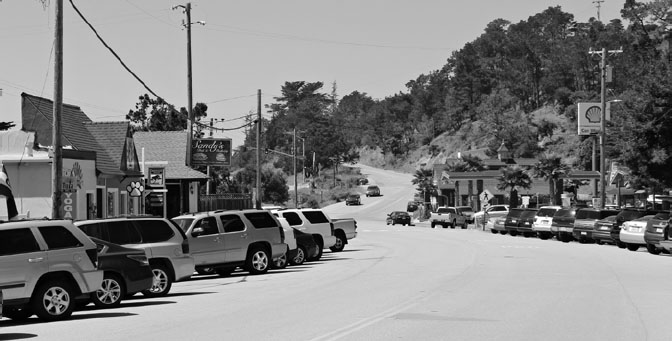
Main Street, formerly Highway 1, through Cambria’s West Village.
The highway winds north through San Simeon, which is little more than a retail strip and a few scattered homes, and on past Hearst Castle, which is visible on a hilltop to the east. Newspaper mogul William Randolph Hearst hired architect Julia Morgan to create the 165-room mansion that included lavish indoor and outdoor pools, a grand dining hall, and a theater for movie screenings. It housed hundreds of antiques and works of art from across the ages, spanning the classical, medieval, and Renaissance periods, and Hearst used it as a showplace/playground for friends from Hollywood and Washington, D.C.
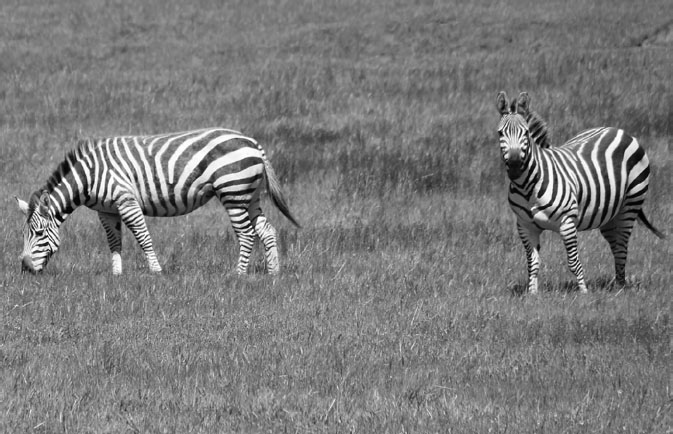
There was even an extensive zoo on the 127-acre site that, at one time, featured camels, llamas, emus, kangaroos, Barbary sheep, and even four giraffes. Although most of the animals were sold off in 1937 when the zoo was dismantled, zebras still roam the hillsides of the estate—now owned by the state of California—and can often be seen grazing beside Highway 1. Tours of the castle are available, and docents dress up as characters from the Hearst era for special occasions.
Zebras descended from a herd brought to the San Simeon foothills by William Randolph Hearst can often be seen grazing alongside Highway 1.
About five miles farther north is an elephant seal rookery, where the marine mammals play and (mostly) sleep on the beach by the hundreds, and farther on is the Piedras Blancas Light Station, which dates to 1875.
One of the last pieces of civilization you’ll hit before the road starts to ascend along the craggy coastline toward Big Sur is Ragged Point, site of the Ragged Point Inn. The current owners built a snack shack there back in 1961 after buying the land from a carnival owner who had left a bunch of rusting old rides and other attractions on the site. The simple roadside stop grew gradually, with the owners opening an upscale motor inn and developing a complex that came to include a restaurant, coffee bar, retail shops, and gas pumps. But the biggest attraction is the breathtaking panoramic view of the Pacific and the coastline you’ll find there. If you look northward, you’ll see the highway ascending up the hillsides, and there isn’t much except wonderful scenery from there on till you hit the Big Sur redwoods.