16
What Can Be Done? The Current Condition of the Waters and their Restoration
A bleak prospect?
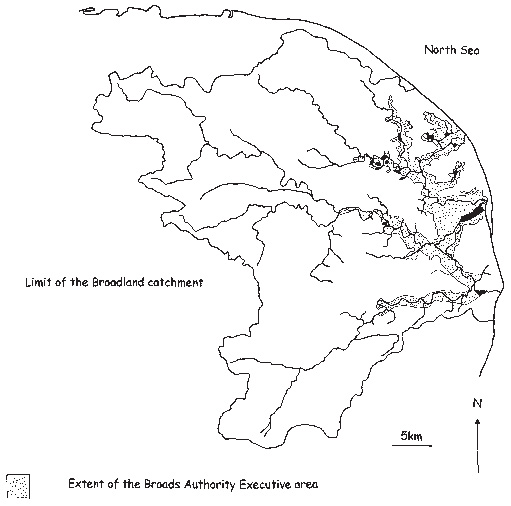
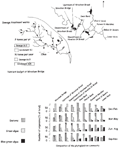
Inexorable changes and handicapped, if willing, authorities: a bleak assessment of the waters of Broadland and the means to restore them, but true. The solutions are well understood; there are still gaps in the scientific understanding, but they are not such as to preclude action. The action necessary can be taken to some extent, and more has been taken in recent years than ever before. The two key organisations that might promote such action, the Environment Agency and the Broads Authority, but they are not backed by sufficiently comprehensive or powerful enough legislation to cope. This becomes very clear from an examination of the key documents produced by each organisation – the strategy and management plan of the Broads Authority, the Broads Plan 1997 and the Local Environment Agency Plan for the Broadland Rivers of June 2000. Both organisations make as much use as they can of the tools available, but the restrictions imposed by the need for compromise and the lack of legislation to manage the catchments are very clear. The ultimate problem is that remediation of the Broads requires wiser management of the entire catchment as well as a cluster of local solutions. The Broads Authority has limited powers but wide influence and enthusiastic motivation in its local executive area, but this is less than 10 per cent of the catchment (Fig. 16.1). The Environment Agency has potentially wide powers over point sources of pollution, such as industrial discharges and sewage treatment works for the whole catchment, but virtually none over the diffuse pollutants of agriculture, and its operations are strongly determined by national politics.
The first difficulty in restoration is that there is now pouring into Broadland, from its catchments, a quality of water that is not compatible with the diverse biological communities that are remembered from 50 and more years ago. The second is that the structure of the river ecosystem has been destroyed by the damage that boats have done in the past and which, although boat activity is better managed now, is impossible to repair without temporary, but severe, local curbs on that activity. And the third is that the ecosystems of the Broads have switched to dominance by planktonic algae. Their return to the submerged plant communities of former times requires improvement of the water quality together with in situ measures that also require closing Broads from boat and other access for a period of some years. None of these problems is easily solvable. All have been tackled to the extent that current possibilities allow, but progress has yet been modest and is unlikely to be hastened in the near future.
Fig. 16.1 The Broads Authority’s executive area, although it covers the traditional area of ‘The Broads’, in fact covers only about 10 per cent of the catchment that determines much of what happens in the floodplains.
The scientific background
Current understanding of the system (of both rivers and Broads) is summed up in the alternative states model discussed in Chapter 12. The key, if a more diverse, attractive system is wanted, is to switch what has become a phyto-plankton-dominated, turbid water system to the clear water, plant-dominated system that characterised Broadland until the 1960s. In doing so it is also important to restrict the plant growth to somewhat less than it became in the weed-choked channels of the late nineteenth and early twentieth centuries, when sewage and its effluent promoted the great swathes of weed through which Arthur Patterson had trouble rowing. One need in doing this is to reduce the nutrient supply, but this alone (unless it were to be so severe as to allow very little human use of the catchments) will not be enough. The original plant communities could survive enormous increases in nutrients; likewise the plankton can persist even with substantial decreases.
What first has to happen is that any potential forward switches, which jeopardise the plants, are removed. These might include herbicide levels capable of killing plants or pesticides of zooplankton. They also potentially include intense grazing by geese, or physical damage by boats, wind and wave erosion, or very high salinities (Chapter 12). Switches that operated in the past will not necessarily be operating now; there may be new ones that must be identified and dealt with.
Then the nutrient concentrations have to be reduced and this probably means those of both phosphorus and nitrogen. Although nutrient reduction will not alone solve the problem, the effectiveness of the next step, called bio-manipulation, increases greatly as the nutrients are reduced. Biomanipulation means changing the fish community so as to encourage the development of grazing zooplankton. The zooplankters then clear the water, creating the potential for water plants to grow.
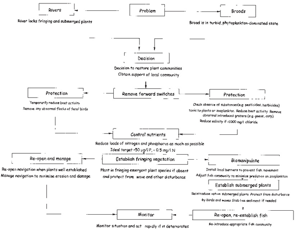
This potential may not be achieved, however, if there are no plant seeds or sprigs remaining, so plants may have to be introduced as the next step. They are very vulnerable to bird grazing and other disturbance at this stage, and may need to be physically protected until they have started to spread. A particular problem appears to be that the sloppy sediment now being laid down provides insufficient purchase for the rather rudimentary root systems of many submerged plants. Finally, an appropriate fish community can be reintroduced and the results monitored. This strategy (Fig. 16.2) gives a framework for discussion of practical restoration in the Broads and rivers.
General approach in the rivers…
In the rivers, it may never be possible to bring back extensive submerged plant communities without complete closure for removal of fish stocks and prevention of their return during the restoration period, but it is possible to restore some of the plant community. Restoration of the emergent plant communities – reeds and irises, reedmace and water-lilies – to re-form a more attractive wave-absorbing defence, would bring back a much more pleasant bank edge, with its associated birds and mammals, than the present eroded ugliness of many stretches.
The first step, with improvement of water quality, is the diversion of boat activity (the probable main forward switch in the rivers at present) from sections to be restored. This need not involve total exclusion, but certainly alternating one-way traffic and traffic-calming measures. There must be a regrading of the edge to a more gentle slope, where a vertical cliff has now been eroded, to provide a favourable habitat. Then appropriate species must be planted and protected from bird damage until they have begun to spread. Finally, there can be the return of the section to use by boats and anglers, though perhaps with increased thought being given to design and operation of the craft and management of the anglers.
…and the Broads
In the Broads, the general approach, again following nutrient control, is isolation so that fish can be removed and their re-entry from the river prevented for a time. Forward switches such as high pesticide ingress are less likely to be operating now, but boat damage and bird grazing are both likely. (At Hickling Broad, salinity is an issue, though this problem has been circumvented in a rather remarkable way by a severe reduction in nutrients, as will be related below.) Finally, the Broad may be reopened provided nutrient control has been general rather than local and that boat activity is initially controlled. A well-developed, tangled bed of submerged plants can effectively defend itself from boats by simply excluding them. Fish will naturally recolonise from the river. This is the theory. The next steps are to look at the techniques available for each stage.
Nutrient control
The keys to nutrient control are to minimise the intensity of cultivation and fertilisation and restore semi-natural vegetation to the catchment (Chapter 3) where possible, and to intercept the nutrients that come from stock and people. Algae need both nitrogen and phosphorus to grow prolifically, and it used to be thought that control of only one would be sufficient to limit growth. Theoretically this is true. Phosphorus has been the target of most control because it enters lakes and rivers from mostly discrete (point) sources such as sewage treatment works, or farmyards. Its compounds can be more readily precipitated than the very soluble ones of nitrogen, which come in from thousands of field drains and diffuse land runoff. Often, however, when phosphorus has been controlled in point sources, there has still remained a substantial supply from release from the lake sediments or diffuse leaching from cultivated land. In many shallow lakes there has probably always been sufficient phosphorus released from the sediments to maintain a large crop of algae provided nitrogen supplies are adequate (Chapter 12).
Fig. 16.2 A strategy for restoration of aquatic plant communities to the Norfolk Broads and rivers. This approach is also generally relevant to other shallow lakes.
The process of eutrophication in shallow lakes may then have been driven as much by increases in nitrogen as of phosphorus, and at different times of year either nitrogen or phosphorus may be more crucial to the algae. Moreover, if diverse communities of plants are to be restored, reduction of nitrogen is probably essential. The plants can obtain adequate supplies of phosphorus but not nitrogen from the sediment, and high nitrogen supplies in the water lead to dominance by a few or only one competitive species. In like manner, weeds such as nettles come to take over fertile soils. The most successful strategies of control for Broadland will thus reduce supplies of both elements. Therein lies the problem.
Control of phosphorus at waste water treatment works has been carried out routinely in many countries (though only sporadically in Britain) by precipitation of it from the effluent with iron, aluminium or calcium compounds. The effluent concentration can be reduced from as much as 30 milligrams of phosphorus per litre to as little as half a milligram, though more usually one or two milligrams per litre (Fig. 16.3). There is even interest in the chemical industry in extracting phosphorus from this process for re-use in industrial products such as detergents. The only problem is in precipitating it in a form that the industry can use, but this will no doubt soon be solved.
Phosphorus control from human effluent is also promoted by a European Directive (the Urban Waste Water Treatment Directive) that requires all works treating the sewage from over 10,000 people or the equivalent, including industrial effluents, to remove phosphorus to a specified level. Member states need only do it where the waters receiving the effluent are defined as eutrophic or at risk of becoming so. This allows individual governments to use the legislation fully or weakly by the way they define ‘eutrophic’. The British Government has defined very few waters as sensitive, mainly those used commercially for water supply and, somewhat surprisingly, only three Broadland rivers, the Wensum, Ant and Bure, have been so defined, and then only in 1998. Nonetheless, phosphorus precipitation is carried out at works on the River Ant and some on the River Bure, as a result at first of voluntary co-operation on an experimental basis by Anglian Water and then through the system of issuing official consents to discharge by the Environment Agency. It has, however, been extremely successful in reducing phosphorus concentrations in these rivers.
Many problems remain however; there are many small works that do not fall under the Urban Waste Water Treatment legislation, yet ten works treating the sewage of 1,000 people each, though not covered, release as much phosphorus as one works of 10,000, which is. The Broadland catchment has nearly 200 sewage treatment works. Works that are distant from the floodplains tend to be ignored, yet phosphorus can easily travel from the headwaters to the flood-plains; and phosphorus released from the large works serving Norwich on the River Yare can be transferred by the spring tides far up the other rivers. Therefore there is still a great deal of phosphorus being released into the Broadland system from sewage effluent, but legislation exists, were it to be used, to eliminate this source almost entirely.
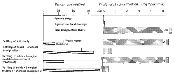
Fig. 16.3 Sewage, from humans or stock, contains much more phosphorus than water draining natural vegetation (pristine water) or agricultural land. After minimal treatment (settling and disposal of solids to land) the remaining water still contains a lot of organic matter (measured as the biological oxygen demand, or amount of oxygen that is used up by bacteria in it in breaking down the organic matter) and phosphorus. Conventional treatment, in which the organic matter is oxidised by a protozoon and bacterial community on filter beds or in activated sludge tanks at a treatment works (biological oxidation), still leaves thousands of times the concentration of phosphorus in pristine water and hundreds of times that in field drainage. Chemical precipitation by iron or aluminium salts from the sewage water removes at least 80 per cent. Full treatment (settling, oxidation and chemical precipitation) can remove more than 95 per cent of the phosphorus, still leaving ten times as much as in pristine water, but the ultimate effect is small when the effluent is well diluted in the receiving river water. Based on Gilbert & De Jong (1978).
Phosphorus from the land has been the minority component of the Broadland phosphorus budget – probably around 25 per cent in the Ant and Bure before phosphorus precipitation from works on these rivers, even less in the Yare and Waveney, where larger towns discharge to the rivers (see Fig. 12.4). It dominates the budgets of the Trinity Broads on the Muck Fleet, which receive effluent only from a few septic tanks. In the River Thurne it dominated the budget in the early decades of the twentieth century, was superseded by the excretion of black-headed gulls from the middle to the late decades and has now come to dominate again as the gulls have declined in numbers.
In the past it was accepted that rather little phosphorus ran off cultivated land, because the insolubility of its compounds leads to its being held rather tightly on the surfaces of clays and other soil components. The fertiliser industry has maintained the view that cultivation also led to little phosphorus loss on the basis that the percentage of loss, compared with what was put on the land, was very small. The problem with this is that a small percentage can be a large absolute concentration. To soil scientists, used to thinking in terms of grams of phosphorus per litre of soil, the couple of hundred micrograms of phosphorus per litre that might leach out in the water seemed trivial, but for algal growth these are huge supplies. Even so, formerly it was generally true that supplies from the land were small.
Currently, however, evidence from Northern Ireland and elsewhere is suggesting that soils, heavily fertilised since the 1950s, are becoming saturated with phosphorus, as eventually they must. The number of binding sites on the clay particles is finite; the amounts put on the land are inevitably slightly in excess of the crop needs, to ensure the crop has an adequate supply. With the vagaries of weather it is impossible to balance exactly the supply and the need and, from the farmers’ point of view, sensible to err on the side of excess. Most soils probably have sufficient stocks now for them not to need phosphorus fertilisation on a regular basis. However, there is a large industry dependent on the trade, and with crop profits dependent on the yield beyond that production needed to cover costs – most of it – there is no great incentive for more parsimonious use.
The only way of controlling these diffuse phosphorus sources, other than through changing the nature of agriculture, is to attempt to intercept them before they reach the streams. Much hope has been put in buffer zones and constructed wetlands. Buffer zones are areas of semi-natural vegetation kept between the agricultural land and the streams, in which uptake by plants and retention of phosphorus-containing eroded particles might provide a barrier. They can be effective (because their wet soils promote denitrification) for nitrogen, but are less so for phosphorus. Just as agricultural soils can become saturated with phosphorus, so eventually must those of the buffer zone and the wetter soils close to the stream will likely release phosphorus (see Chapter 4).
Buffer zones must therefore be extensive for long effectiveness, and this means not just a token strip a metre or two wide along each bank of a stream. Some calculations suggest that, with current agriculture, almost as great an area of buffer zone will be needed as of agricultural land to be isolated.
Constructed wetlands are a particular form of buffer zone in which an artificial reedswamp is planted in a suitable depression and water channelled through it. Again they work well for retaining silt and decomposing nitrogen compounds to nitrogen gas, but are much less effective at phosphorus retention. Sometimes they are used for the final polishing of sewage effluent, after conventional treatment and chemical phosphorus precipitation, but, despite many hopes to the contrary, cannot cope with waters very rich in phosphorus.
Both parsimonious fertilisation and use of buffer zones depend on voluntary co-operation of landowners. There is a Code of Good Agricultural Practice produced by the Ministry of Agriculture, which promotes their use, but its suggestions are mostly confined to nitrogen and even then are mild compared with what is needed for adequate control. There are no penalties if its provisions are not followed, except where grant money for improvements is being sought and may be refused. The law does not require control of diffuse nutrients.
Stock wastes are probably a small component of the Broadland phosphorus budgets. Farming in the catchments has been dominated by arable for many decades, but dairying in the river valleys, where damp grasslands favour it, and an increasing industry in poultry and pigs, must provide quantities that will become more important as other sources are controlled. There has been a problem of piggery wastes contaminating the River Waveney with ammonium ions, which must also mean that phosphorus supply was similarly increased. The problem was small, however, and dealt with by controlling the pig slurry; storing it and disposing it on the land as fertiliser under conditions that minimise runoff. Manure spread in wet weather can release very large supplies of nutrients to the streams, for the water runs over the surface and not through the soil where there is at least some possibility of retention.
Internal nutrient supply from the sediments
Ultimately all phosphorus and most of the nitrogen comes from the catchments, but phosphorus can be stored in sediments and emerge later as an internal supply. The rate at which phosphate emerges from sediments depends on many factors, for example temperature, disturbance by invertebrates and pH of the overlying water. Despite much research it is not a very predictable process because so many influences affect it simultaneously.
Because most of the release is in summer, when water flows are lowest, and much of the phosphorus may be returned to the sediment in particles of algae and detritus before it can be washed out, this supply may be available more or less indefinitely once quantities of phosphorus have built up in the sediment. It is tempting therefore to attempt to take out the sediments rich in phosphorus to remove this source.
Sediment removal is an expensive business, however, for it is slow and the sediment must be disposed of. Three Broads, Cockshoot, Alderfen and Strumpshaw together with Pound End, part of Hoveton Little Broad, have been suction dredged by pumping a mixture of fluid sediment from them and settling it in lagoons created among the surrounding wetland. Sediment removed from Barton Broad has been settled on agricultural land then ploughed in to the soil and agriculture resumed. Sediment will have to be removed from a much greater area of Broadland in the near future if open water is to be maintained for navigation, for current sedimentation rates, measured in cores dated by lead-210 dating, are of several millimetres, even a centimetre or so, each year.
The results of sediment removal on reduction of phosphorus inputs to the water have, however, been disappointing (see Chapter 10). Perhaps this is inevitable if it is the case that all shallow lake sediments release substantial amounts of phosphorus, even under plant dominance. Results are awaited for Barton Broad where external loads have been reduced by phosphorus precipitation and effluent diversion and where phosphorus concentrations have fallen in a situation where there is a vigorous flushing of the Broad. Summer release of phosphorus appears to be reduced and overall concentrations are falling in consequence. However, the precedents are not good for long-term control.
Nitrogen control
Nitrogen is both an old and a new card on the table. It has always been understood that it was closely involved in eutrophication, but it is very difficult to control. The earliest attempts at solving eutrophication problems were in Canada, North America, Switzerland and Sweden, where the local geology was such as to make phosphorus very scarce and strongly limiting. The problem was mostly one of urban wastes affecting deep lakes, and phosphorus control alone was very successful. This conditioned the thinking about nutrient control on a much wider basis, including Broadland, but in lowland areas, covered by glacial drift, and in shallow lakes, phosphorus is much more available. Thus it may have been increases in nitrogen that have driven the eutrophication of areas such as the Broads. Moreover, the present high nitrogen levels result in much lower plant variety so that where plants have been restored the communities have the instability that is associated with such low diversity and readily collapse. The consequence is that a stepwise decrease in both nutrients is likely to be needed for nutrient control in Broadland, as opposed to the sole control of phosphorus that has pervaded the thinking so far.
Some nitrogen comes from waste water treatment, as ammonium and nitrate, but this amount is trivial compared with that which drains as nitrate from agricultural land. The two approaches of interception by buffer zones and parsimonious use on the land, already discussed for phosphorus, are as yet the only possible solutions. At least for nitrogen, buffer zones and constructed wetlands can be very successful, as in waterlogged soils, especially those whose water tables fluctuate, denitrification by bacteria is effective.
The difficulty is that the loads of nitrate now coming from the land demand quite extensive buffer zones if control is to be effective and farmers are unwilling voluntarily to give up land, on which they could be growing crops, for this use. There is legislation, under a European Directive, that could create areas, called Nitrate Vulnerable Zones, in which farming practices can be legally limited to reduce nitrate levels to below 50 milligrams per litre (ten if the value is expressed as nitrogen, as it usually is). Some 600,000 hectares of land have been scheduled since 1996 as Nitrate Vulnerable Zones, but only small areas of the Broadland catchment, at Lyng Forge, near Wroxham, and in the upper reaches of the River Waveney, have been included. All of the areas so far designated have been to protect domestic ground water supplies, though the Directive promotes use of these zones also to protect sites of value in conservation of wildlife. The British Government has chosen not to use this option, but this has been noticed by the European Community and, in consequence, Britain is threatened with prosecution in the European courts. This has stimulated some thinking, at least, about suitable areas for scheduling.
Nitrate losses from arable agriculture come from both surplus fertiliser use and ploughing of the soil, which promotes decomposition and oxidation of nitrogen-containing organic matter. The Ministry of Agriculture worked out a number of strategies to minimise the losses, which, as in the case of phosphorus, are comparatively small from the farming point of view compared with the nitrogen stored in the soil and taken off in crops. Nonetheless they are huge compared with what would run off natural vegetation into streams and lakes, whose communities thrive on extremely low levels of such nutrients.
The Ministry recommended that high yielding crop varieties be used, which remove a lot of nitrogen. Unfortunately this is a two-edged sword, for a lot of fertiliser has to be used to support them. It recommended minimising the time the soil is bare, following ploughing, by planting cover crops and sowing the seed for the next summer season early the previous autumn. It suggested calculating fertiliser requirements carefully, avoiding fertilisation in spring, when runoff is high, and putting the fertiliser on in stages rather than all at once. And it recommended that the fertiliser be put on carefully, away from watercourses, and that irrigation take more careful account of weather and periods when uptake of nitrogen by the crop is greatest. Manure put on the surface can release a great deal of nitrogen and so it should be ploughed in, or not put on, when wet weather is expected.
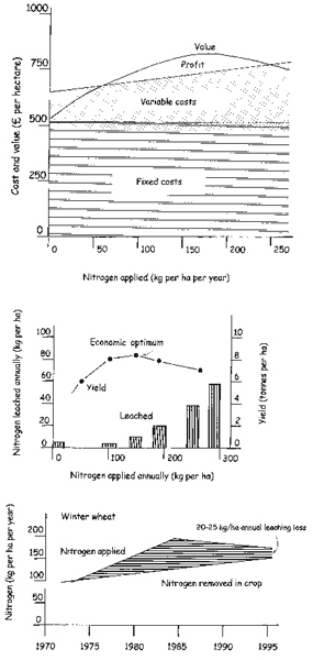
These strategies can reduce nitrate losses significantly, but not prevent them entirely. The fundamental problem is that fertiliser is cheap compared with other farm costs and the profit from a crop increases markedly from the last few per cent of extra yield obtained in response to nitrogen (Fig. 16.4). There will thus always be a tendency to put on a little extra to guarantee this. Leaching losses of nitrate from arable land and vegetable crops can be high, up to 200 kilograms per hectare from brassica crops, but less from cereals, which make up the bulk of cultivated land (4.5 million hectares compared with 0.2 million for other crops in the UK). Changes in practice and increasing yields have reduced potential losses from winter wheat from about 70 kilograms per hectare in the early 1980s to about 25 kilograms per hectare (Fig. 16.4) now. However, because of the vagaries of weather and the economics of crop growing it is claimed that it is unlikely that they can be reduced by much more.
The long-term average runoff of rain (that is the total precipitation minus the evaporation) in Broadland is about 150–200 millimetres per year. Thus a leaching of say 20 kilograms of nitrogen per hectare is likely to create a concentration of 9–13 milligrams per litre of nitrate-nitrogen in general and locally much more. The likely pristine concentration from under natural vegetation would be less than 1 milligram per litre. Some of the nitrate currently leached from the land is denitrified in streams, rivers and upstream swamps before it reaches the Broadland floodplain, so that values of up to 9 or 10 milligrams nitrogen per litre (Waveney, Yare and Bure), or 3–6 milligrams per litre (Ant, Thurne and Muck fleet), are found in water entering the Broads in winter. This is still very high. It means that a combination of both improved practice and interception by buffer zones will be needed to solve the problems of the Broads. There is still some possibility of reduction by designation of the Broadland catchments as Nitrate Vulnerable Zones, but there will have to be substantial conversion of land to defensive use as buffer zones.
The future for nutrient control
Serious attempts have been made to reduce the phosphorus flows into Broadland and these have been very successful in the Bure and the Ant. And there is one instance, at Hickling Broad, discussed below, of reduction in nutrient loads without benefit of any management at all. Yet there has been little impact on the ecological state of the system overall. A much more ambitious approach will be needed.
Greater impetus may be given by the new European Water Framework Directive, agreed in 2000, which requires a whole-catchment approach and the restoration of water bodies to good ecological status, by whatever means is necessary. This can only mean restoration of clear water and plant dominance to shallow lakes and lowland rivers. There are many opportunities within the Directive for member states of the European Union to derogate particular water bodies, but nonetheless it is the first legislation on water quality based on modern understanding of the importance of the catchment.
Fig. 16.4 Nitrate use for agriculture in the UK brings problems for fresh waters that must be seen in the current economic context (top). The profit (including a subsidy, the Arable Area Payment), is a small part of the overall farm costs, but the cost of the fertiliser, between nothing and £150 per hectare (in 1997) is also only a small proportion. The profit is increased with increasing fertiliser use, though not hugely. However, because the other costs are currently high, it is worth putting on ample fertiliser to make sure the maximum profit is attained. The need to meet legislative standards imposed by the European Union on nitrate concentrations in drinking water has led to much research into how nitrate leaching losses might be reduced without affecting farm profits. Long-term studies on land cultivated for wheat at Rothamstead Experimental Station (centre) show the increased loss by leaching as more nitrogen is applied. Above about 150 kilograms per hectare, which also represents the maximum profit, leaching losses increase greatly. Applications in recent years (bottom) have often been greater than this, but the encouragement of more careful practice as well as economic considerations have gradually narrowed the difference between the nitrogen applied and that removed in the crop. This difference, however, which represents the leaching losses to fresh waters, remains at 20–25 kilograms per hectare. In terms of concentration this can be up to 25 mg per litre, or 50 times that which leaches from natural vegetation. It is thought that leaching losses cannot be reduced any more than this under conventional intensive agriculture. Solution of nitrogen problems in fresh waters will thus require a much more radical reform of agriculture. Based on Ministry of Agriculture, Fisheries and Food (1999).
Restoration of the rivers
Until water quality can be improved on a catchment-wide basis it is not worth thinking of re-establishment of submerged plants in the rivers. Restoration of emergent plants is another matter and is possible. There is a variety of river edges (Fig. 16.5). On those upstream, reed fringes still occur, and occasionally water-lilies have persisted, but often past dredging and erosion have created a rather precipitous edge, rather than a gentle batter into the water, stopping any extension of the beds. Then there are those where alder growth has taken over and the edge is also steep with exposed tree roots. Both of these types front undrained fenland.
On river edges downstream, within the floodbanks protecting the grazing marshes, a part rooted, part floating rond may persist, with reed and other grasses, but often erosion has removed this and the water now extends to the floodbank. Finally, there are those sections where piling (quay heading) of wood or steel has already been inserted, because of the need for moorings or to protect property or badly eroded floodbanks. Above the tidal reaches most of the bank has a reasonably natural appearance, but within the tidal sections (around 183 kilometres, counting both banks) about 62 per cent retains something of a natural appearance, with ronds, although confined within floodbanks. Along 21 per cent the ronds have been eroded away, 9 per cent is piled and only 9 per cent retains a truly natural appearance. Everywhere there is erosion to some extent and the irregular plant-fronted edge of earlier decades has been replaced with a starker, straighter line.
Current boat traffic is incompatible with a spontaneous, natural redevelopment of fringing plant communities. Conversely, with the reduced traffic of the last decade or so, some further restrictions on speed, and with some temporary protection, new reed fringes might be established, except where piling has excluded this possibility forever. A reed fringe not only looks better than an eroded edge, but creates habitat for mammals and birds. Only the more tolerant – moorhen, coot, mute swan, great-crested grebe, mallard – are likely to persist, but these are familiar denizens and welcome even if more unusual animals fail to tolerate even modest amounts of boat disturbance.
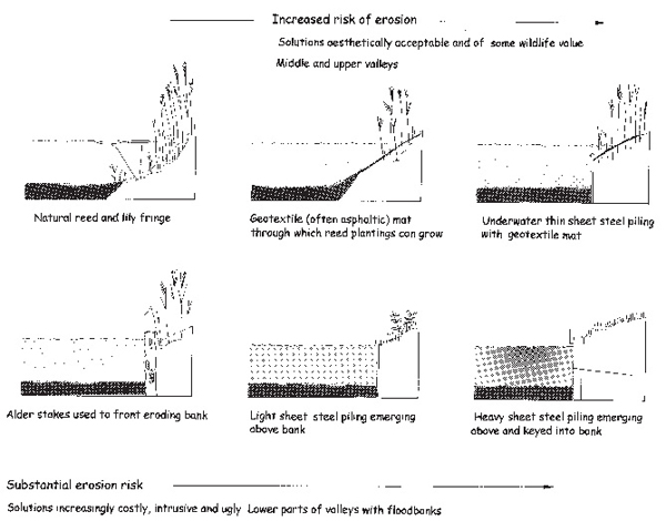
Fig. 16.5 Some examples of bank protection in Broadland.
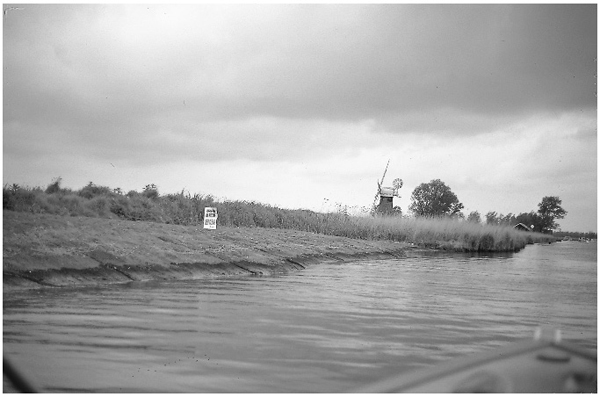
Fig. 16.6 Bank repair along the River Thurne, using geotextile matting that has been pegged over the regraded eroded bank.
In the past the problem has been that attempts at restoration (Fig. 16.6) have been too modest. They have attempted the impossible compromise of establishing the fringe with no control of boat traffic or regrading of the banks. Tough ‘geotextile’ matting has been laid down on the steep banks, with perforations for the reed to grow through, or barriers of car tyres threaded on stakes have been used to give some protection against waves along short sections. Neither has given very impressive results and neither is attractive. Both have been the approaches of conventional engineering.
What is needed first is restriction of boat traffic to reduce disturbance for probably two to three years along substantial sections in turn. This means confining boats to a lane along the centre line and a system of alternating one-way traffic flows so that substantial protection can be given whilst the reed fringes re-establish from plantings. These will need a bank edge that has been re-contoured to a gentler slope and protected by decomposable matting during the time that the reed is establishing. There is no great conceptual problem in arranging this. It is done every day in the repair of roads, even motorways, so it is faintly odd that it should have been opposed so stolidly by the navigation interests in the past. One problem in Broadland is that alternative parallel routes for traffic diversion are generally not available, but alternating one-way traffic over a couple of kilometres at a time would pose no real difficulty for holidaymakers.
The Broads Authority, now the navigation authority, has the powers to carry out such work under such circumstances, but has hitherto been slow to use them. Its preference has been to promote development of less damaging boats, through changes in hull design. Sensible and necessary though this is, it will not solve the ultimate problem, for when edges are eroded, spontaneous recovery is impossible, even at much lower levels of disturbance than can be tolerated with an intact vegetation fringe.
Restoration of the Broads
The Broads are, in theory, less difficult propositions for restoration of clear-water, plant-dominated conditions than the rivers, simply because they can be isolated. The results of local restoration have been promising, but limited and to some extent disappointing – low diversity of plant communities and a tendency to revert – because it has not been possible to reduce the nutrient loads sufficiently.
The strategy described in Figure 16.2 was worked out in hindsight. It is an ideal that can act as a reference to assess what should be done. The first step is to remove forward switches that might disturb a plant community. The problem is that it is never possible to be certain that none are operating, especially where there might be trace toxic substances, but at present in Broadland, boat damage and grazing by birds are the most likely agents, with salinity also an issue in the Thurne catchment.
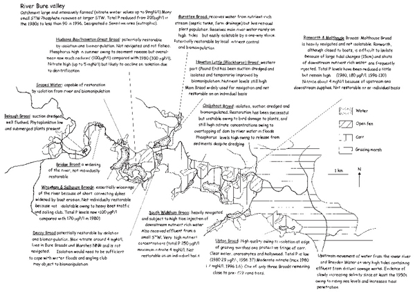
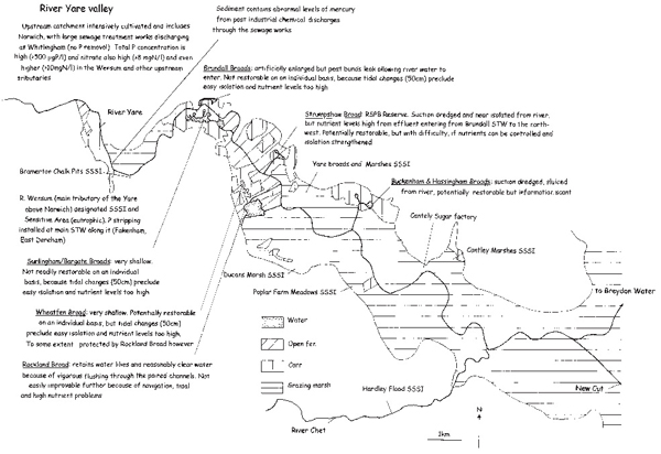
Small-scale experiments in enclosures that protect against physical disturbance in Broads along the River Bure have shown that plants can be established and grow well (Fig. 16.7). This means that chemical switches, such as pesticides or trace toxic substances potentially present in sewage effluents, can be discounted in the Bure. This might not be the case on the River Yare, where there is a large waste water treatment works serving Norwich, which has more varied industry than elsewhere and has discharged effluents with heavy metals such as mercury in the past. However, there is a substantial plant community, mainly of water-lilies, in Rockland Broad downstream of it, so even on this river, physical damage is likely to be the switch mechanism most to be guarded against.
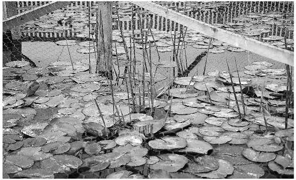
Fig. 16.7 Protection from physical damage and especially bird grazing can result in some plant growth in turbid waters, but these measures, coupled with biomanipulation, can give excellent growth. In this experiment, at Belaugh Broad, a slatted palisade of wood prevents birds from entering, whilst the flushing of the river at this point minimises phytoplankton development.
The second step is to reduce the nutrient loads as much as possible and this topic has been discussed above for the desirable catchment scale. On a local basis it is possible to reduce nutrients by isolation of a Broad from the river or diversion of inflow streams around it, as related in Chapter 12.
Biomanipulation
Following nutrient control, the strategy for restoration (Fig. 16.2) moves to biomanipulation. The aim is to clear the water of algae by husbanding the growth of populations of Daphnia, thus creating better conditions for plants to grow on the bottom. In the absence of the refuges that plants naturally provide (Chapter 12), and which allow coexistence of large numbers of Daphnia with substantial fish stocks, this can only be done by removing the fish that eat the Daphnia.
There are several ways of doing this. The first, and best, is to remove as many fish as possible, leaving only a few fish predators such as pike to hunt the fish that always remain after even exhaustive fishing. Inevitably this interferes with angling. The second is to remove only the species of fish that produce many young that feed on Daphnia in their early stages, such as roach and bream, but leave bottom-feeding fish such as tench, which do not form such large populations and do less damage, as well as the piscivores. This is more acceptable to anglers, but such selective fishing is more expensive. The third is to increase artificially the stock of piscivores such as pike. This is effective only if very large numbers are added and has to be done year after year, at great expense, because the young pike do not survive very well. Pike also function best among plant beds, which are, of course, absent at this stage. Adult perch are also piscivorous, but again prefer weedy conditions and their young are also zooplanktivorous.
The option of introducing exotic predatory fish such as the zander (pikeperch) is precluded under the Wildlife and Countryside Act. It would, in any case, be undesirable in principle, introduced species everywhere having created rather more problems than they have solved. The significance of zander is that it is an open-water shoaling fish, which, unlike pike, does not depend on the cover of plants for its hunting. It is native to mainland Europe and undoubtedly occurred in Britain during the interglacial periods, but the accident of history prevented its reinvasion before Britain became an island 8,500 years ago.
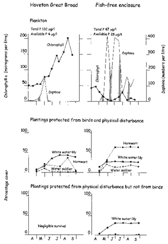
In Broadland the first approach, complete removal, has generally been taken, with fish removed to the main rivers. Biomanipulation has been carried out in Cockshoot Broad, Pound End (Hoveton Little Broad) and Ormesby Broad as well as in small-scale experiments of up to a hectare or so in Hoveton Great Broad (Plate 1). These have demonstrated its feasibility (Fig. 16.8) even where nutrient control has not been very great. Biomanipulation is now a commonly used technique and has been employed widely in mainland Europe. Research in Broadland has contributed significantly to understanding of the technique and its limitations.
Fig. 16.8 Removing fish can have a substantial effect on the plankton in shallow lakes and thence on light penetration and plant growth. The plant growth, however, is also affected by other factors including physical disturbance by waves and by bird grazing. The experiment from which these data are taken is shown in Plate 1. An enclosure, about 1 hectare in area, was made with plastic and wood sheets, perforated by stainless steel mesh windows, in Hoveton Great Broad. These allowed free exchange of water. Fish were removed from inside the enclosure, but remained outside it in the main Broad. Plants were planted in protective structures (Fig. 16.7) inside and outside the enclosure. The protection comprised circular wooden fences with slats spaced widely enough for birds, particularly coot, to enter (protection from physical disturbance only) or narrowly to prevent such entry. The latter structures were also covered with netting to prevent birds flying in. Removal of fish allowed considerable numbers of Daphnia to persist (upper panels) and this had an effect on the phytoplankton, which was greatly reduced, and the water chemistry. The phosphorus content fell as particles containing phosphorus were sedimented in Daphnia faeces, but the available portion of it increased as the Daphnia excreted it but prevented, by their grazing, further uptake of it. The plant growth, measured as individual coverage of the water surface, was best and in greatest diversity when protected from birds in the clear water of the fish-free enclosure. They did not survive unprotected in the open Broad, but even there, protection from birds allowed lesser growth of white water-lilies and hornwort. The persistence of plants was thus shown to be a function of a package of circumstances. Based on unpublished data of J. Stansfield, C. Bennett, G. Phillips and B. Moss.
There are several conditions that make biomanipulation most effective. Firstly, there should be no more than about 1 gram of fish per square metre (10 kilograms per hectare) remaining. This compares with about 20 grams per square metre in ‘normal’ waters and twice as much or more in those heavily stocked for angling. In water that lacks refuges for zooplankters, even a small stock of fish can undermine the grazing potential of Daphnia. Methods for removing fish are generally confined to the least effective, but more ethical ones. Use of a natural fish poison, rotenone, or of gill netting are most efficient but kill the fish; electrofishing, where the fish are stunned in an electric field created between two electrodes placed in the water, or seine netting, are less efficient, but the fish survive. It is comparatively easy, though time-consuming, to fish out a small lake of only a few hectares, but much more difficult to fish out one even of only a few tens of hectares.
Fishing is best done in winter, when many small fish from the previous summer will have grown to a more catchable size or been removed by natural predation. In winter, at low temperature and high oxygen levels, damage to the fish is also minimised. Piscivorous fish are usually put back – they might control the residual population of other fish – and so are eels, which do not feed on zooplankton and will get back anyway, for they can travel overland through wet vegetation. All other British lowland fish feed on zooplankton, when they are small, though tench never breed prolifically and are not much threat and might also be returned. Roach, bream, rudd and perch all feed voraciously on zooplankton until they are at least ten centimetres in length, in their first and sometimes second year of life. Thereafter they feed on larger animals.
The second condition for the success of biomanipulation is obviously that the fish cannot return to the lake. This means isolation by some form of barrier, which means curtailment of navigation, for where boats can pass, so can fish. Cockshoot Broad was isolated by a solid dam, Ormesby Broad by a raised mound of pebbles on its small outflow that allowed row boats to be slid over it into the Broad, but that prevented fish from passing. Other forms of barrier, such as curtains of tough but flexible plastic sheet with floats at the surface that might allow boats to pass over them, are being tested (Plate 25). Fish could in theory pass over them also as the boat depresses them, but are likely to be scared away by the disturbance.
The need for isolation restricts the number of Broads that can be biomanipulated, because of the navigation issue. It may also preclude successful biomanipulation because of the effect on the algal populations through reduction of flushing. A well-flushed Broad, at current nutrient levels, has a phytoplankton dominated by diatoms and green algae in summer, with only a small proportion of blue-green algae. The latter grow slowly and develop best in water that is not flushed through very rapidly. Isolation generally means reduced flushing and greater proportions of blue-green algae.
The problem then is that blue-green algae are less palatable to Daphnia than diatoms and green algae. They are more rubbery in texture, harder to eat and difficult to digest. They may also produce toxins, so that the Daphnia reject them from their feeding grooves. Experiments in a well-flushed Broad (Hoveton Great) compared with a poorly flushed one (Ranworth) have shown that exclusion of fish leads to development of abundant, large, efficiently feeding Daphnia only in the former. Where blue-green algae dominate and populations are already well established, Daphnia fail to grow well and the larger species, which are the more efficient grazers, do not grow at all (Fig. 16.9). Sometimes, however, in shallow lakes, biomanipulation carried out over the winter can prevent the development of the blue-green algae because the Daphnia can sometimes, though not reliably, control the small residual populations of blue-green algae by which these species overwinter.
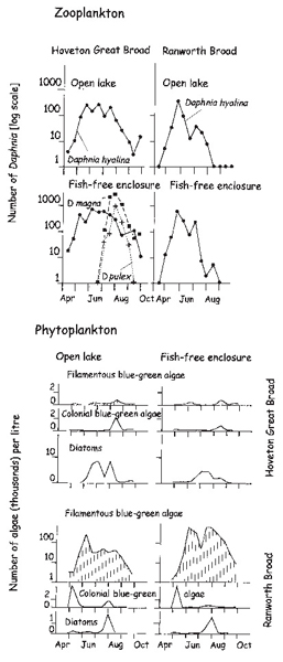
Fig. 16.9 The influence of fish removal on the development of the zooplankton may sometimes depend on the nature of the phytoplankton community. The experiments were carried out in fish-free mesh enclosures in the well-flushed Hoveton Great Broad and the poorly flushed Ranworth Broad, with their very different phytoplankton communities. Based on Moss et al. (1991).
One theoretical solution is to pump ground water through an isolated Broad, but this has not yet been feasible for lack of adequate supply of high quality ground water. The ground water supplies in Broadland are mostly already over-committed for public supply and irrigation. Another is to make the isolation barriers permeable to water, but not to fish or their tiny larvae. This can be done by building barriers of sheet plastic, or wood, with windows of stainless steel mesh (Fig. 16.26). The windows soon clog with algae and detritus, however, and must be frequently scrubbed clean with a wire brush, but the approach might allow successive areas of a large Broad to be isolated, whilst maintaining flushing, and allowing navigation and angling over the remaining area. When a substantial proportion of the Broad has been restored, the barriers might be removed, but this approach has only yet been tried with the establishment of a single such enclosure in Hoveton Great Broad (Plate 1 and Fig. 16.8).
The third condition for successful biomanipulation is that nutrient levels should be reduced as much as possible. If the algae are severely short of nutrients and not growing well, they can be controlled by a much less active Daphnia population and perhaps by less severe biomanipulation. At present it is not possible to be very precise about how much nutrient reduction is needed. It is easier to get modest reductions than significant ones and hence there is a tendency to compromise at levels that are not nearly so stringent as are probably needed.
Getting the plants to grow
Biomanipulation, by promoting Daphnia development, clears the water so that plants can potentially grow, but it does not guarantee their growth. There may no longer be live seeds left in the sediment and vegetative fragments will usually have long disappeared. Sometimes, however, a few plants have persisted, or fragments are brought in by river flows and may establish. More often plants have to be introduced and may find it difficult to become established.
The sediments laid down under phytoplankton-dominated conditions are amorphous and fluid, lacking in the fibrous material that binds together the sediments laid down under plant-dominated communities. Small plants may easily be dislodged by water movements or uprooted by birds such as coot, foraging for invertebrate food around them to feed chicks in spring, or eating them directly later in summer. This means that plantings may have to be protected against disturbance from both waves and birds by cages, which may be prominent and unsightly, but nonetheless necessary.
Of the two whole-lake restorations yet carried out in Broadland, at Cockshoot Broad and at Ormesby Broad, the plant populations have developed much better at Ormesby Broad. There was a substantial starter population already present, which expanded considerably after biomanipulation. At Cockshoot Broad, there was no plant population left, even before sediments were removed, and plantings, which were unprotected, fared badly except in one very sheltered area that had been the dyke connecting the Broad with the river before isolation (Fig. 16.10). The main body of the Broad acquired growth of hornwort, but it never established very vigorously and its fortunes have fluctuated greatly from year to year. This lack of stability in the plant populations is a common feature of restoration attempts and may be linked to still high nutrient levels in the water, particularly of nitrate. Ormesby Broad has quite low nitrogen input, whilst Cockshoot Broad receives nitrate-rich Bure water several times each winter when floods circumvent the dam that otherwise isolates it from the river.
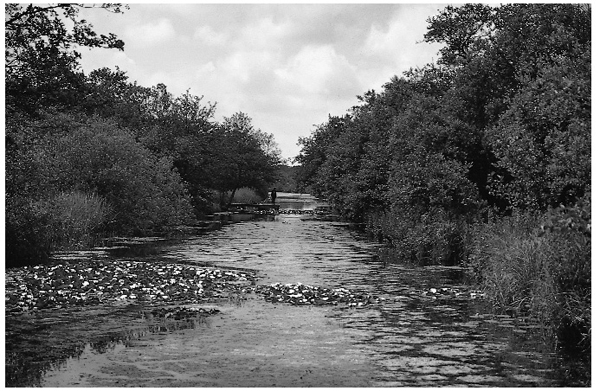
Fig. 16.10 Following isolation and biomanipulation, the sheltered areas of Cockshoot Broad developed vigorous populations of plants, but these have not been very stable.
Reintroduction of fish
The next step is to reintroduce a fish population, which ideally should have predators such as pike and a range of native fish, but not introduced species such as common carp. Carp are not the problem in Broadland that they are elsewhere, where large stocks have been introduced to shallow lakes for angling, and have ruined the structure and diversity of the system by acting as forward switches. There are few carp in Broadland waters, and it would be undesirable to increase the number. Fortunately, under present climatic conditions, carp do not breed easily in Britain. It is generally too cool.
In the Broadland restorations so far there has been no deliberate restocking of fish after biomanipulation. The residual populations have been allowed to redevelop in Ormesby Broad, and the instability of the plant community in Cockshoot Broad has meant that this stage has not yet been contemplated. However, experience elsewhere suggests that a community of pike, perch, rudd and tench is most appropriate to stable plant-dominated shallow lakes, with roach and bream also normally present but not dominant, as they are in turbid waters. Bream, like carp, can be damaging to establishing plant populations because they forage in the bottom sediment.
Monitoring
The final step in such lake restorations is to monitor the results carefully and learn new lessons about what are quite complex systems. There are almost always complicating factors and the general strategy outlined above was developed on the basis of experience in hindsight. In general, in restorations of shallow lakes in Europe, results have been very good where nutrient levels were low, a residual plant population remained, and almost all fish were removed. They have been most disappointing where nutrient levels remained comparatively high, plants had disappeared entirely or fish stocks remained substantial. One Broadland restoration, at Ormesby Broad, is in the first category, the other, at Cockshoot Broad, perhaps in the second.
The scale of the problem
Lakes are parts of river systems and rivers are inseparable from their catchments. If restoration of the Broads has been slow, it is partly because the scale on which it has been tackled is too limited. Although it is possible to do something about a small lake, if it can be isolated from its catchment, it is rarely a long-term stable solution. There are many ways in which its ecology is interdependent on that of surrounding wetlands and adjacent water bodies as well as on the nature, the amount and the seasonal distribution of the water delivered to it.
One small lake in the Netherlands, called Zwemlust, which had been restored from a turbid plankton-dominated state to clear water with aquatic plants for a few years, suddenly reverted to turbid water in the late 1990s. A build-up of coot, from the ditches of the surrounding, largely drained land, concentrating on an attractive new food source, overgrazed the plants and switched the lake back to a turbid state again. Formerly such lakes, like the Broads, were part of whole river-floodplain systems where the larger-scale availability of food and habitat precluded such concentrations of birds. The potential restoration of the Broads and rivers is thus best looked at in terms of the river catchment units – the Ant, the Thurne, the Muck Fleet, the Bure, the Yare and the Waveney. A geographic tour will reveal the possibilities and problems.
The River Ant
The Ant (Fig. 16.11) is a small river, with a catchment that is less intensively farmed than those of the Yare and Bure, but more than that of the Thurne, lying close by, to the east. In one stretch it was straightened and deepened to form a canal in the late nineteenth century, with locks at North Walsham and Honing. The valley floor is largely of fen, carr and reedswamp, with the result that the high nitrate concentrations draining from the distal arable lands of the catchment are much reduced, though still significant. A waste-water treatment works serving Stalham discharges effluent, and there is also some food factory effluent entering through the Smallburgh Brook. Much of the phosphate has been removed from these by precipitation and the nutrient loads entering the floodplain stretch are now lower than formerly.
Tributaries, including the former Stalham and Sutton Broads, which are now confined to channels through the infilled reedswamp and fen, join the river before it enters one of the larger of the Broads, Barton, still bordered by extensive wetlands on most sides. The river once flowed around the Broad in a channel still discernible from the pattern of the ditch system in the Catfield fens to the east of the Broad, and in the winding line of the Parish boundary. This immediately puts the Broad at a disadvantage for local restoration, for it is now part of the main navigation of the River Ant, with large boat yards situated at Stalham.
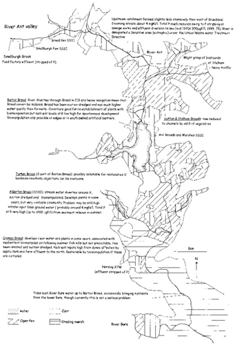
Fig. 16.11 Potential of the River Ant for restoration of the Broads.
Below Barton Broad, at the edges of the valley, are two small Broads, Alderfen and Cromes. These also are flanked by wetland, though it is limited in extent. The river then becomes embanked in its lower reaches and the wetland has been drained to grazing marsh, the topmost fringe of the extensive sward that reaches down to Halvergate and Yarmouth.
Barton Broad figured prominently in the early thinking that the solution to the problems of the Broads lay primarily in the reduction of phosphorus in its inflows. The loads from the point sources have been reduced to about a third since the early 1980s and there has been a parallel decrease in the concentrations (Fig. 12.7) but there has been no return to clear water or plant colonisation of the Broad.
Further reduction of the phosphorus supply by removal of sediment thus was apparently a sensible strategy, though experience elsewhere is that there is inevitably sufficient supply left, after removal of what is practicable, to make rather little ultimate difference. A major dredging programme has been carried out at Barton Broad in an attempt to reduce the internal supply, as well as to deepen the water to improve the navigation. The Broad is now approaching a state where a restoration of aquatic plants is likely to be successful if biomanipulation could be carried out. Nitrate levels are modest in the upstream river (3–4 milligrams nitrogen per litre) and become reduced by denitrification as water moves into the Broad. A substantial plant population in the northern part of this large Broad would cause further reduction so that stable, diverse communities could develop in the southern section.
Alas, biomanipulation of such a large Broad, on a major navigation route, is extremely difficult; in fact currently impossible. There is also the risk of a new forward switch as tides sometimes push saline water up the river and into the Broad. Salinity has not yet reached the sorts of levels that would threaten Daphnia, but rising sea levels and greater tidal surges might do this in the future.
Alderfen Broad and Cromes Broad lie on small tributaries. That serving Alderfen Broad was diverted easily around the Broad in 1979 and that action gave rise to temporary euphoria when a modest crop of hornwort developed. Its fortunes fluctuated and in some years it dwindled and algae grew to abundance (Fig. 12.10). Phosphorus concentrations were high, despite isolation, because of release from the sediment and, despite sediment removal in 1994, they have remained high. The lake has also suffered fish-kills as well as deliberate experimental biomanipulation. It still has a fluctuating plant population, but it is becoming increasingly difficult, with such a diverse management history, to sort out cause and effect.
Cromes Broad, isolated from the river in 1992, has had better fortunes following sediment removal in 1988, but it is equally difficult to say why because it has not been extensively monitored. It has not been biomanipulated, but there is anecdotal evidence of summer fish-kills in 1999, which may indicate that the fish community has been subject to similar events in previous years. These may have reduced the fish community sufficiently for plants to have become more securely established and able to cope with intervening years of greater fish survival. The plant community is again more or less confined to hornwort, but the fish community, though it fluctuates greatly, may be less dominated by zooplanktivorous fish at present than in the past. It has a greater proportion of piscivores such as perch and pike, which are associated elsewhere with maintenance of clear water conditions. One problem, however, is that drains to the north may still be bringing in large loads of nutrients from farms and septic tanks. They were extremely rich in phosphate and ammonium when monitored in the 1980s.
The dykes deep in Reedham Marsh, the wetlands to the west of the River Ant, have a rather more diverse flora. They are isolated by tortuousness and distance from the river and well protected by wide fens from the agricultural land and, towards the centre of the area, have very low nutrient levels and rich plant communities. In contrast, the three Broads considered here, Barton, Alderfen and Cromes, are all still subject to close influence from diffuse sources of both nitrogen and phosphorus. Much has been done in attempts to restore the Ant system, but the intentions are dogged by an inability to tackle the wider problems of the catchment’s diffuse nutrient sources, an underlying theme throughout Broadland. There are, too, the problems of biomanipulating a Broad such as Barton, particularly the internal problems of compromising between ecological restoration and navigation, which will prove to be a second overarching theme.
The Thurne and its Broads
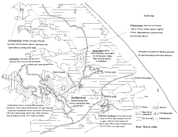
The medieval bridge at Potter Heigham (Fig. 16.12) forms a notional gateway to the Broads of the River Thurne (Fig. 16.13). It is low and narrow, infinitely more attractive than the ugly new concrete bridge that crosses the river to its north, and restricts the flow upstream of tidal water from the lower reaches of the Thurne and the Bure to the Thurne Broads. This is important, for the Bure water is rich in nutrients whilst the Broads of the Thurne remain the least eutrophicated of all Broadland. There are no sewage treatment works discharging into the system above Potter Heigham bridge, though a modest works, serving Ludham, discharges into Womack Water, a tributary three kilometres below the bridge. Some, but probably not much, of this water may move upstream on the tide. To the north-west and west the catchment is of arable land, but the area is small, and the bulk of it lies to the north and east, bordered by the North Sea, and is mostly of low-lying grazing pasture. An area close to Horsey Mere and Martham Broad has been more intensively cultivated for cereals in recent years, however. Most of the water entering the main Broads, Martham, Horsey Mere and Hickling, is pumped from these levels up into the waterway, which is held in by embankments (Fig. 16.13).
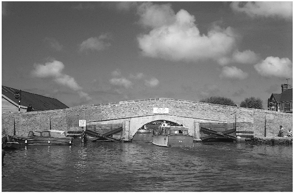
Fig. 16.12 Potter Heigham bridge forms something of a gateway to the Thurne system, probably minimising, with its narrow openings, inputs upstream of nutrient-rich river water on high tides.
A very small Broad, Calthorpe (Fig. 16.14), lies isolated to the north, surrounded by alder carr, and is heavily vegetated with yellow water-lilies and some remaining submerged plants. It is a good example of the process of filling-in by encroachment of vegetation and now has very little open water. Robert Gurney, who once owned it, records in his diaries from the 1920s that he spent much time trying to clear out lilies to delay the process and maintain open water.
In 1970, following earlier increases in the intensity of drainage of the adjacent level, Calthorpe Broad became very acid (pH 3) as peat in its surrounding wetlands dried and oxidised, producing sulphuric acid and ochre (Chapter 14). When heavy rain washed more acid into the Broad that winter, there was a fish-kill and deaths of three species of freshwater mussel (Anodonta cygnea, Anodonta anatina, Unio pictorum) that had been common, and of toad eggs and frogspawn the following spring. There was a similar event in the dry year of 1976 and pH values now frequently fall to 5.5, whereas previously they had always been above 6. Though Calthorpe Broad is still dominated by plants, it has fewer species than previously, and is dosed with chalk from time to time to counteract the acidity. This is a palliative measure; the fundamental solution would have to be the raising of the water table.
Close to Calthorpe Broad, the New Waxham Cut, a long, straightened channel, flows between embankments and receives water pumped from a swathe of land separated from the sea by a thin line of dunes, which its course parallels. It turns south into Horsey Mere, bringing with it water that is heavily loaded with ochre and salt (Fig. 12.23). The salinity in Horsey Mere rises to about 20 per cent of sea water, much higher than it was earlier this century. What the salinity might have been prior to that, when the Thurne system was an estuary discharging through what is now the Hundred stream close to Martham Broad, is not known.
The Broads in this area have the familiar characteristics of peat or clay pits and could only have been excavated following blocking off of the Thurne estuary at the outlet to the present Hundred stream. The picturesque restored Horsey Mill (Plate 17), close to Horsey Mere (Fig. 16.15), presides over a Broad that no longer has the clarity of former times, but which is turbid with colloidal ochre and phytoplankton. The net flow from Horsey Mere is through Meadow Dyke and into a Broad, called Heigham Sound, which is effectively a widening of the river. Water is ponded back in the system on the rising tide that forces water from Horsey Mere into Hickling Broad, and sometimes vice versa in summer. On the falling tide, the flow from Meadow Dyke into Heigham Sound and down to the Thurne can often be seen from a boat because of the different colours of the Meadow Dyke water and that upstream of it at White Slea and in Hickling Broad.
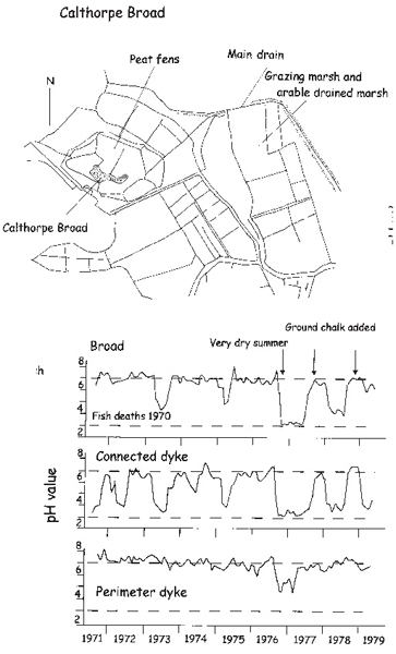
Fig. 16.14 Calthorpe Broad lies at the top end of the Thurne system, in a peat fen that is relatively base poor. Drainage of the land to the east has reduced water levels around it and resulted in severe ochre and acid production. In 1970, pH fell to 3 and fish were killed. Because drainage in the area has remained intense, the Broad (upper panel) continues to be vulnerable especially in dry summers and pH often fell to 3 or 4 in adjacent dykes in the peat in the 1970s (central panel). The marginal dyke receives water from the upland and is, to some extent, protected (lower panel). In the late 1970s, following dry summers in 1977 and 1978, ground chalk was added to the Broad to neutralise the acid and improve conditions for the freshwater community. This is just a treatment of symptoms, however, and the Broad no longer has the plant and invertebrate community it formerly had; the cause remains, its solution ultimately resting in the nature of agriculture in the catchment.
Some water comes directly into Hickling Broad, through Catfield Dyke, from the catchment to the west, and is not saline, but the flow is low for the area is small. It is in general richer in nutrients, however, than that coming in from Horsey Mere. The net effect of these inputs is that Hickling Broad is much less well flushed than Horsey Mere, and saline, but at around 10 per cent of sea water, less so than the Mere. The recent history of Hickling Broad has been very dramatic. It has changed from a clear-water Broad earlier this century to a turbid one between 1970 and the late 1990s, a very clear one in 1998 and 1999 and in 2000 is turbid again. The story of these events is intricate.
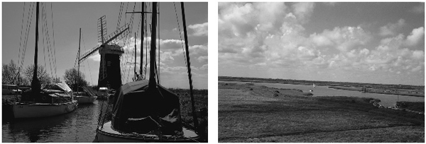
Fig. 16.15 Horsey Mill presides over a Broad, Horsey Mere, which suffers from high salinity and ochre problems. It is, however, potentially restorable through a move back to high water table pasture agriculture in its catchment.
The self-restoration of Hickling Broad
The eutrophication problem that Hickling Broad has suffered was due to the development of the large roost of black-headed gulls described in Chapter 12. This problem has not affected Martham Broad, which is isolated at the top of the River Thurne. Martham is one of the three Broads (the others being Upton Broad in the Bure valley and Blackfleet, close to Meadow Dyke) that still retain very clear water and communities of charophytes and the rare hollyweed. Blackfleet and Upton Broads are both isolated from river flows by extensive fens.
In Martham, as in Upton Broad (there is little information on Blackfleet Broad), the phytoplankton is likely to be limited by phosphorus. These Broads have concentrations much lower than 50 micrograms of phosphorus per litre and they are positioned, in the alternative states scheme (Fig. 12.17), in the space at the upper left where nutrient concentrations are low enough to give unique dominance of plants. There is simply not enough phosphorus or nitrogen to support sufficient phytoplankton or periphyton to create a problem for the plants. Hickling Broad and Horsey Mere, however, although they are close to both Martham and Blackfleet Broads, have undergone major changes.
The water pumped into them, through the Waxham New Cut from the Brograve Level, rose in salinity in the middle part of the twentieth century as pumping intensity increased. The nutrient contribution from the gulls also rose and resulted in the events related in Chapter 12, including loss of most of the plant biomass (Fig.12.24).
The symptoms were at their worst in the 1970s, but there was continuing change in the 1980s. The plants never entirely disappeared and clumps of three species could always be found even in the 1970s – fennel pondweed, spiked water-milfoil and mare’s tail. Hickling Broad and Horsey Mere are linked by Meadow Dyke and, with the daily pulse of the tide, water can be moved between them upstream and downstream, especially when the flows pumped in from the catchment are low or lacking in summer. The chemical effects of the gulls could thus be transferred to Horsey Mere even though the gulls generally did not roost there.
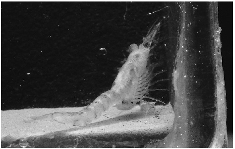
Fig. 16.16 Neomysis integer, a mysid shrimp versatile in both its salinity and food requirements, has played an important role in the changing ecology of Hickling Broad.
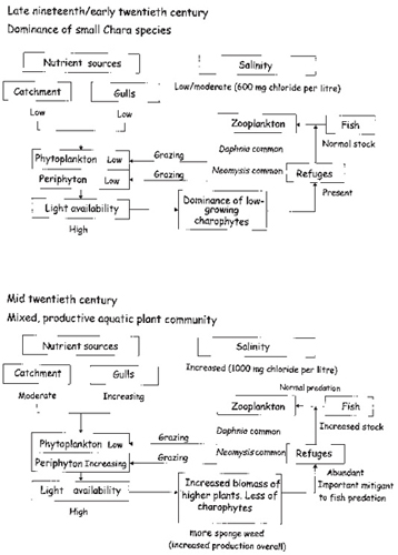
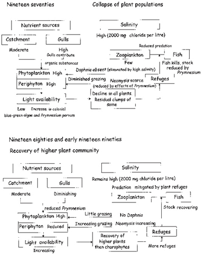
Fig. 16.17 Hickling Broad changed greatly in an almost cyclic fashion in the twentieth century. This and Figs 16.19 and 16.22 summarise the relationships between the main components of the system. This figure shows the workings of the system as it would have been seen by the Reverend Bennett at the turn of the nineteenth century (upper). The lower part shows it as it slowly changed until the middle of the twentieth century through build up of the gull roost, and a small intensification of agriculture. This resulted in a slight rise in salinity, which probably had a negligible effect. Based on Bales et al. (1993).
In the 1980s there was a small but progressive recovery of the plants, which accelerated in the 1990s. This recovery was associated with a reduction in the phosphorus concentration of the water. The gulls were decreasing in numbers, apparently as the local waste tip near Martham village was covered over and provided less daytime attraction for them. The plants may have been able to persist because one of the common salt-tolerant crustaceans in the Thurne, a mysid shrimp, Neomysis integer (Fig. 16.16), is an omnivore, capable of scraping periphyton from the surfaces of the plants and thus improving the amount of light able to reach their surfaces. This shrimp has been very abundant in the Broad, following possible setbacks caused by the Prymnesium toxins, to which it is vulnerable. Figure 16.17 shows the relationships within the Broad prior to and during the 1970s.
The 1980s saw a progressive extension of the area covered by plants in Hickling Broad and even of some charophyte species and hollyweed. The water remained brown, despite a decrease in the phytoplankton, because of the ochre both in suspension and adherent also to the mucilaginous wall of the dominant blue-green alga, Aphanothece clathrata. Conditions were clearly improving, however. The gulls continued to decline, but there was still a substantial reserve of phosphorus available in the surface sediments in the form of gull excreta yet to decompose. The early 1990s saw further increases in the area of plant cover in Hickling Broad (Fig. 16.18), less in Horsey Mere, possibly because of the greater ochre problem, possibly because nitrogen levels are higher there, it being closer to the catchment sources. The plant densities became great enough for the local sailing club to have difficulty getting through the beds in summer and the weed had to be cut – for the first time since the early 1970s.
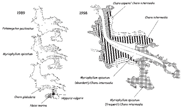
Fig. 16.18 In the 1980s and 1990s, Hickling Broad began to recover its plant populations (left). In 1998, recovery had reached a stage by which charophytes, particularly the rare Chara intermedia, had come to dominate. Based on Bales et al. (1993) and Eaton (1999).
Fig. 16.19 In the 1970s (upper), Hickling Broad changed greatly. Nutrients from the gull roost reached a peak, agricultural changes had increased the nineteenth-century salinity threefold. The gulls not only provided inorganic nutrients, but their guano was a rich source of organic compounds that may, with the rising nutrients and salinity, have stimulated the large populations of the toxic phytoplankter, Prymnesium parvum. This alga caused fish-kills and possibly also kills of large invertebrates such as the mysid shrimp, Neomysis integer. The high salinity removed daphnids and the consequences were much less grazing on phytoplankton and periphyton. Turbidity became high and most of the plants disappeared. However, as the gull roosts and their imported nutrients declined in the 1980s and 1990s (lower) the Neomysis recovered, the algal crops began to fall and the plants slowly returned. Daphnids remained very scarce because salinity had not changed, however, and the water remained quite turbid, the plants benefiting mostly from a reduction in their periphyton burden. Based on Bales et al. (1993).
No management had been carried out in the Broad or catchment that can explain these events. They simply followed from the decline in the gull roost and movement of the birds elsewhere, perhaps because of the closure of the waste tip where they had been feeding, but this is unlikely to be the entire cause. The excreta of the gulls we had studied in the 1970s included parts of contraceptive sheaths which suggested they had been feeding also at sewage treatment works and they feed on the land also. Many charismatic photographs show gulls following the plough. Bird flocks sometimes show changed behaviour for no obvious reason and the birds now roost on Breydon Water and the sea.
At this stage it seemed likely that Hickling Broad would stay a somewhat turbid water with beds of vascular plants such as the water-milfoil and pondweeds, for Daphnia remained scarce and grazing pressure on the remaining phyto-plankton low (Fig. 16.19). The plants benefited from grazing over their surfaces by Neomysis, but any major increase in the clarity of the water seemed unlikely as long as the salinity remained high enough to exclude Daphnia. Reduction in salinity would have meant changing the agricultural regime of the catchment, where it had been converted to arable agriculture, and raising the water tables. There was no prospect of this.

Fig. 16.20 In the 1990s, the populations of charophytes steadily increased in Hickling Broad, culminating in dominance over much of its area by a rare species, Chara intermedia, in 1998 and 1999. Despite its rarity, it grew very vigorously in the Broad.
Rather surprisingly, therefore, in 1998, the waters cleared and huge growths of charophytes appeared, including a predominant Chara intermedia, but also several other species, and this situation persisted in 1999 (Fig. 16.20). Chara intermedia, though no shrinking violet, for it grows vigorously, is nonetheless a very rare species, growing in only a handful of other locations in the UK and apparently nowhere else. The annual flow-through of water must have flushed out the critical last tranche of gull-provided phosphorus that had been left in the sediments and brought nutrient concentrations low enough to give the charophytes the advantages they apparently have at very low nutrient levels. The sheer biomass built up may also have reduced the phosphorus levels further for they dipped below 50 micrograms per litre in the summers of 1998 and 1999 (Fig. 16.21). Events may be tentatively put together as in Figure 16.22.
The renewed clarity of the water is something of a mystery, for the brown ochre colloids are still being formed in the catchment and still enter the system and colour the water in Horsey Mere and in winter in Hickling Broad. Charophytes, however, produce organic substances that may suppress algal growth and that may also flocculate fine particles. Hickling Broad, without benefit of learned opinion or practical intervention, had recovered to close to the state it had been in the late nineteenth century when the Reverend Bennett described its great swards of charophytes.
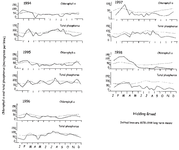
Fig. 16.21 Changes in the total phosphorus and phytoplankton chlorophyll a concentrations in Hickling Broad between 1994 and 1998. Data are shown in each year in comparison with the long-term mean (1978-98). The marked fall in concentrations of both chlorophyll a and total phosphorus in the summers of 1997 and particularly 1998 is clearly shown. Data from the registers of the Environment Agency, published in Eaton (1999).
There was no universal rejoicing, however. The conservation bodies, English Nature and the Norfolk Wildlife Trust, were extremely pleased. The members of the local sailing club were not. A European Directive, the Habitats and Species Directive, had been passed in 1992, which required the Government to schedule sites of great conservation interest as Special Areas of Conservation (SAC), for which a target state for maintenance or improvement had to be set. Hickling Broad had not finally been scheduled as an SAC, but it was on a list of sites awaiting this distinction and was treated as if it had been finally scheduled. Its target state was a clear-water lake with predominant charophytes and this had been achieved, with the additional piquancy of a very rare species.
The conservation status of Special Areas of Conservation is to be regarded as pre-eminent in the face of possible development. The conservation bodies were thus opposed when the Broads Authority, as the navigation authority, proposed to cut a substantial area of the charophytes in the centre of the Broad to permit competitive sailing. The sailing club had blossomed in the years of open water between the 1970s and 1990s and the sailors had become accustomed to no impediment to their progress. The charophytes were very much in the way and there were strong demands for the cutting. English Nature and the Norfolk Wildlife Trust, which owns the land surrounding the Broad, but which do not have responsibility for the navigation, feared that cutting might permanently damage the charophytes and switch the Broad back to a more turbid state with mostly vascular plants. The Royal Society for the Protection of Birds feared that the increases in coot, gadwall and other herbivorous birds, which depended on the plants, especially in the winter when charophytes persist as perennials, would be reversed.
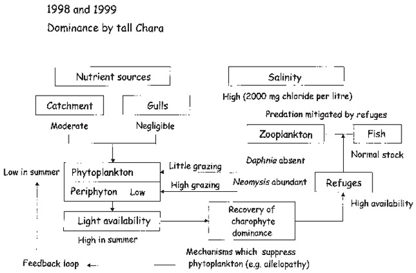
Fig. 16.22 In 1998 and 1999, Hickling Broad charophyte communities recovered strongly. The nutrient source from the gull populations was by then negligible and the charophytes, which had been recovering slowly in the 1990s, gained dominance over vascular (higher) plants. The Broad has not yet quite attained the conditions of the late nineteenth century (Fig. 16.17) with low-growing charophyte species. The current charophytes are rank and aggressive, perhaps because nutrient levels from the pumped water are higher than they would have been then (nitrate and ammonium concentrations are relatively large) and partly because salinity levels remain high. Daphnids have not reappeared.
The Broads Authority was caught in the dilemma of having to fulfil its duties under the Broads Act as the navigation authority and its duties under the Habitats Directive to achieve the target status for a Special Area of Conservation. Its constitution demands it be all things to all men. Clearly this was impossible, especially with a strong Navigation Committee. In such circumstances the Habitats Directive demands an appropriate enquiry by an independent panel. The panel, in 1999, decided that a lesser regime of cutting than had been proposed was unlikely to cause permanent damage and was necessary to assess the effects of cutting so that future decisions could be made on a rational basis.
An area was cut that might allow sailing races (though in fact was not, in the end, very convenient), but would not affect most of the Chara beds, and the results were that such limited cutting, and perhaps rather more, would not seriously jeopardise the state of the Broad. The tensions that the issue has raised, though, are indicative of the continuing problem of trying to maintain the multiple uses of Broadland, a position that is not often possible whilst also retaining high quality of use in any respect. Multiple use means universal mediocrity.
The Hickling story is not yet over, however. In 2000 the Chara grew much less well and most peculiarly, the pondweed and milfoil appeared to be dying. They had survived 20 years of previous turbid conditions. There was also a small resurgence in growth of Prymnesium parvum (Chapter 12) which had caused fish-kills in the 1970s. Cutting of the plants for navigation reasons was not necessary and tensions subsided, but the circumstances of plant decline in 2000 are odd and not easily explained by the natural changes in the environment of the Broad.
If a stable charophyte community is to be retained in Hickling Broad and if Horsey Mere is to be restored to clear water, the solution probably now lies in a reduction in pumping and a rise in the water table in the catchment. This will have the multiple effects of reducing ochre formation, reducing the input of nutrients from the catchment and decreasing the salinity. At present, neither Broad has cladoceran zooplankton capable of grazing phytoplankton very efficiently, though formerly, when salinities were lower (perhaps a third of present values) Hickling Broad, at least, certainly did. The evidence comes from the meticulous field notes kept by Robert Gurney and preserved in the Castle Museum in Norwich.
Martham Broad
Martham Broad, or Broads (Fig.16.13) if you care to distinguish the section north of the dyke from that to the south, is well known and probably the most diverse of the Broads in its plant populations. It is favoured by having a small catchment and by lying at the top end of the system where it is better flushed by water draining through gravity from slightly higher land to the east and south. Like Hickling Broad and Horsey Mere, it has no sewage treatment works in its catchment. It has, however, doubled in salinity from around half that in Hickling Broad (1,000 milligrams chloride per litre) in the 1970s to similar values (1,800 milligrams per litre) from the 1980s.
This increase in salinity arose because the owners of the nearby land in the Somerton Level decided to deep drain and plough the former grazing marshes in the early 1980s. The result was an increase in ochre as well as salinity, for the Level has frequently been flooded by the sea and has sulphate-rich soils. The ochre, although it precipitated phosphate from the water and reduced total phosphorus concentrations to 20 micrograms per litre, unprecedented for modern Broadland, threatened to smother the plants and invertebrates. Negotiations between the Internal Drainage Board and the then Nature Conservancy Council led to relocation of the main pump from above the Broad to the Hundred stream, effectively now parallel with it, and a weir was installed to contain the ochre, which is periodically dredged out. The increased salinity remains, however, because of tidal back flow of some of the Hundred stream water and because a smaller pump still operates above the Broad. The Broad has retained its quality, however, and even Somerton Dyke, above the Broad, is rich in plants, despite its popularity for boat mooring. Conservation of water and ecosystem quality in Martham Broad needs no particular action, merely protection of its present favours.
The Muck Fleet
The third of the smaller rivers of Broadland and also, like the Ant and Thurne, a tributary of the River Bure, is the Muck Fleet, which discharges six kilometres below the confluence of the Thurne and the Bure. It has a sluice where it enters the Bure so that water cannot pass up it on the tide from the Bure, and is headed by a complex of Broads: Ormesby North and South, (Little) Rollesby, Lily and Filby, collectively called the Trinity Broads (Fig. 16.23). They receive water from a largely arable catchment that contains several villages. The villages are served by a sewerage system that removes effluent to well outside their catchment, so there is no problem with point sources of phosphorus, apart from a few septic tanks serving isolated cottages and farms.
The water quality is not as poor as that of the Broads on the main rivers, but it is not without nutrient problems, the origins of which have been difficult to pinpoint. Ormesby and Rollesby Broads, the larger of the group, have generally clear water and have retained some aquatic plant communities. These Broads are slightly deeper than most others so light penetration to the bottom is lower than in shallower waters and it is the combination of agricultural eutrophication and greater depth that disfavours the plants. Ormesby Broad has been biomanipulated, which improved the water clarity and extent of the plant populations considerably.
Lily Broad now has rather few lilies and quite a large phytoplankton population and Filby Broad is also phytoplankton-dominated. Filby is hemmed in by a number of houses and a village and may receive more septic tank effluent than the others in the group, whilst the small stream entering Lily Broad from arable land with some cottages is also poor in quality. Ormesby Broad, which is also used as a water supply for Yarmouth, is at the head of the system with few houses very close and this correlates well with its having the best water quality of the group.
There are well-developed reed fringes around most of the group and from time to time Ormesby has become very clear, in years when fish recruitment has perhaps been poor and Daphnia populations have increased. The combination of circumstances in this group is such that, with some attention to sources of nutrients, substantial improvement could be possible. Some septic tanks may leak to the surface waters more than necessary if they were functioning at their best, and could be improved. An extension of the alder carrs that fringe most of the inflowing streams into more substantial buffer zones, and ensuring that the water diffuses among the wetlands rather than passing directly through, could also help. Biomanipulation has made a considerable difference to Ormesby Broad and this suggests that the nutrient threshold for making the improvements stable is not too far below the present state.
The River Bure
The Bure is the epitome of the Broadland system for the holidaymaker, and a nightmare for ecological restoration. It is a large system (Fig. 16.24), though smaller than those of the Yare and Waveney, draining a large catchment of intensive arable agriculture. It bears several substantial villages and small towns – Aylsham, Buxton, Coltishall, Wroxham and Hoveton and Acle – all with sewage treatment works discharging to the river. It is tidal to around Wroxham and bleak between its embankments in the lower reaches, which are bordered by grazing marsh. It has many Broads, with all but Burntfen and Upton linked to the river by wide dykes, mostly open to navigation. And it is the most popular area for tourists and boating, with attractive wooded sides in the upper reaches and the amenities of villages, pubs and churches in the middle, where the Broads are situated. It also has poor water quality and is plankton-dominated almost throughout.
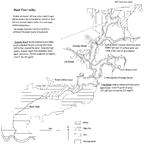
Fig. 16.23 Potential of the Muck Fleet for restoration of the Broads.
Upton Broad is the best placed. It is one of the few Broads to retain reasonably clear water and an aquatic plant community containing charophytes and hollyweed and is protected by thick belts of carr and fen. It is connected by a dyke system to the surrounding fens and receives some water from the upland arable catchment to the south, but it is isolated from the river by a thick belt of grazing marshes separated from the fens by an embankment. Some additional nutrients reach it from the upland, but the problem can probably be contained by diffusing the water through the carrs rather than allowing free passage through the dykes. This might simply mean putting dams on the inflows to force the water out over the carr and allow the carr to act as a nutrient filter.
Cockshoot Broad is next in quality for it has been the subject of intensive research and experimental restoration for 20 years. The beginnings of this story were related in Chapter 12. When it was thought that nutrients alone were the problem in the Broads, Cockshoot Broad was dammed from the river and much of its sediment was removed. There was an immediate improvement; the water cleared and Daphnia were very abundant, but progressively they declined and the phytoplankton increased before aquatic plant populations could become well established. Lilies that had been planted flourished and hornwort also, especially in the area that had been the dyke, but not in the main basin to any extent. What appears to have happened is that the noise of the suction dredging had scared most fish out to the river and they had not been able to return because of the dam. There had thus been inadvertent bio-manipulation as well as isolation from nutrient sources and this had led to the increase in Daphnia and the clearing of the water (Fig. 12.10).
The residual fish population, however, soon recovered. The Daphnia, lacking much refuge from the fish, were decimated and the phosphorus concentrations also increased as a result of release from the remaining sediment. In the winter of 1987/88 the fish were deliberately removed and the Broad immediately cleared again and remained clear because, each winter, for the next several years, fish that had persisted were removed. Plants grew, though not in great quantity except in the sheltered dyke area, and not in great diversity.
The reasons for this may be that they were unable to withstand the grazing of coot and other water birds and never exceeded the threshold that would allow them to establish and withstand grazing, and also that nutrient levels remained quite high. Much phosphorus was released from the sediment, shots of high-nitrate water reached the Broad from the river when the dam was bypassed by winter floods and the nitrogen supply from the remaining southern stream may have been substantial despite the carrs through which it passed.
The best plan for Cockshoot Broad would therefore seem to be to improve its relative isolation, to diffuse the inflow water from the southern stream more, to plant in a rather large inoculum of plants capable of growing rapidly enough to keep ahead of coot grazing, and to continue biomanipulation until this plant population is substantial. This, however, is a piecemeal solution that might maintain one rather small Broad in an interesting state, but does nothing for the greater problem of the river as a whole.
The wider Bure problem
Above Belaugh, the Bure is a river, for the rate of replacement of the water is rapid enough for there to be insufficient time for much phytoplankton to develop before the water passes downstream. It is clear and plants develop on the bottom. But below Belaugh there are almost no plants and a succession of phytoplankton communities develops. The Bure from that point ‘works’ not as a river with a set of associated lakes, but as a single convoluted lake. Understanding this is crucial to its restoration.
The individual Broads are like bays of this single lake and the river itself flows so slowly that it develops as much phytoplankton as any of its Broads and thus acts as the main basin of the lake. Water rich in nutrients enters at the upper end; tides pond the water back and cause it to be retained for quite long periods and also bring nutrients upstream from the sewage works in the lower reaches. There was also a small sewage treatment works discharging directly to South Walsham Broad.
As the valley widens below Wroxham, Broads start to appear – close to the river at first but more distant from it downstream. This effect of distance, and therefore of different degrees of isolation from the river, means that water is flushed out of the Bure Broads more rapidly upstream, but retained in them on average for longer downstream. This can be discovered by adding tracer dyes to the water and following their progressive dilution, or by doing the same thing by measuring chloride dilution after a shot of sea water has been injected following a storm surge tide. The different flushing times lead to different phytoplankton communities upstream and downstream (Fig. 16.25). Upstream, with water being retained only a month or less in the Broads in summer, diatoms tend to develop, with only a few blue-green algae. But in the downstream Broads (Fig. 16.25), with water held for several months in summer, filamentous blue-green algae come to dominate. This all has implications for restoration.
A restoration strategy on this part of Broadland will only work if it concerns the whole river. It is not possible to do the job Broad by Broad because it is not legally possible to isolate any of them from the river. There is a long-standing right of navigation on tidal waters and all but Belaugh Broad and possibly Burntfen Broad, which lies distant from the main river on a small side stream, are tidal. Boats regularly enter most, and those that are closed to boat entry from the river by their owners for all or part of the year (Hoveton Great Broad, Hudsons Bay, Hoveton Little Broad, Decoy Broad, Ranworth Broad) have substantial tidal exchange of water with the river. Isolation might prove illegal if challenged in the courts.
If the restoration strategy (Fig. 16.2) is applied, therefore, a major obstacle is in reducing the nutrient loading to the river as a whole. A start has been made on this by installation of chemical phosphorus stripping at four sewage treatment works, Briston, Aylsham, Coltishall and Belaugh, whilst at Acle the effluent is passed through a reed bed in an attempt to improve it, though not very successfully. The effluent from the small works at South Walsham Broad has also been diverted. The phosphorus stripping has been effective and has reduced total phosphorus concentrations in the upper reaches from more than 200 to less than 100 micrograms per litre in the last few years, but this is still too much to result in spontaneous return of clear water and aquatic plants. A substantial proportion of phosphorus must now come from agriculture (it was about 25 per cent in the 1980s, before phosphorus stripping) equivalent to about 50 micrograms of phosphorus per litre in terms of its contribution to the concentration. If current thinking about the importance of nitrogen is correct, the problem becomes formidable, for nitrate inputs from the catchment are very high.
In the lower reaches, the comparatively large works at Acle provides a lot of nutrients to the middle section of the river. Water is pushed back upstream and into South Walsham, Ranworth and Malthouse Broads, at least, from this source, whilst the tides also bring the even more nutrient-rich water that the Yare provides to Breydon Water into the lower reaches, and sometimes perhaps even the middle reaches of the Bure. Estuarine animals such as Neomysis integer sometimes appear in winter as far up as Cockshoot Broad.
Fig. 16.25 The algal communities of the River Bure change steadily down river, as do those of the associated Broads. As retention times increase (i.e flushing rates decrease), blue-green algae become more prominent, especially in the low flows of late summer and autumn. The River Bure is influenced by a large number of small sewage treatment works, and a few large ones. Before processes to remove phosphorus were installed at four of the latter, the nutrient budgets for nitrogen and phosphorus at Wroxham Bridge were as shown. Sewage effluent dominated the phosphorus budget and agriculture that for nitrogen. Currently effluent contributes probably around half of the phosphorus whilst the budget for nitrogen is unchanged. Based on Moss et al. (1984).
On the positive side, much of the Bure floodplain upstream is not built on and could be reinstated with wetland to encourage nutrient removal and much could be done about the many smaller sewage treatment works that discharge to the tributary streams in the upper part of the Bure. However, ultimately, nothing but a major change in land practices will restore the Bure to a stable state of clear water. Prior to that, there are still problems with forward switches. Birds and boats, however, are the most obvious.
There are flocks of feral geese, especially greylag and Canada geese, which graze the turf around Salhouse Broad to a lawn of garden height (Fig. 13.5) and would certainly make inroads into any starting population of aquatic plants in the shallows. This area of Broadland is also the most popular by far for boats. Any restoration plan would have to restrict boat access temporarily, Broad by Broad, whilst biomanipulation was carried out.
The big problem, however, is that biomanipulation would have to be done on a huge scale more or less simultaneously unless all the Broads were separately isolated and closed to boat traffic for several years. In doing this, flushing times would be affected. If the nutrient loading is not reduced considerably, the potential for growth of large phytoplankton crops will remain and with reduced flushing, blue-green algae will be favoured. Blue-green algae are not readily consumed by Daphnia. One way around this problem, in principle, is to isolate the Broads from fish entry by barriers with mesh windows (Fig. 16.26) that allow water but not even the smallest fish larvae to pass.
Under the present constraints, the Bure system will mostly remain a turbid phytoplankton-dominated system, except for a few showpiece sites: Cockshoot Broad, Pound End (a small part of Hoveton Little Broad that has been isolated) and perhaps Hoveton Great Broad and Decoy Broad. The latter two have not been sailed on for some time and might be amicably completely isolated and biomanipulated. Given the present difficulties of substantial nutrient reduction, especially of nitrate, perhaps these only can be restored and maintained, though with continuous intervention, as lakes with plant communities of low diversity – small victories in an unwinnable war.
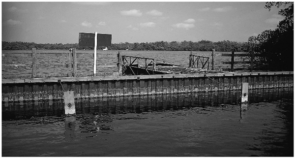
Fig. 16.26 Areas of large Broads can be isolated by mesh window barriers, which allow circulation of water and continued flushing, whilst preventing re-entry of fish after biomanipulation. This barrier was used to separate Pound End, part of Hoveton Little Broad. The mesh windows, covered by stainless steel, are visible at the waterline. In tidal conditions they must be frequently brushed clear of periphyton or they may clog and the subsequent difference in water levels may result in undermining of the barrier by water currents.
The River Yare
The Yare is Broadland’s biggest river, with its substantial tributaries, the Wensum and Tas and the smaller Tud, converging around Norwich, below which the main floodplain begins (Fig. 16.27). There are several Broads – Wheatfen, Surlingham, Brundall, Strumpshaw, Rockland, Buckenham and Hassingham – though all but Rockland are small. Of the others, filling-in by vegetation has reduced most to little more than widenings of the fen dyke system so that Brundall, Strumpshaw and Buckenham and Hassingham have been dredged out to increase the area of open water. The Broads cluster along a short stretch below Norwich, for the land beyond is very low lying and the clay deposits become thick not far below Rockland Broad. The river is then embanked and the valley floor covered by grazing marsh, which merges into that of the Halvergate triangle. The water is extremely rich in nutrients, largely because of the sewage treatment works at Whittlingham below Norwich. Effluent from the next largest towns of Dereham and Fakenham, which are far upstream on the Wensum, the main tributary of the Yare, is now phosphate-stripped in an attempt to improve that river, which is ecologically of perhaps the highest quality in Broadland.
The flow of the main Yare is high and the tidal rise considerable, so that retention times in the Broads are short. Phytoplankton has much less time to develop than in the Bure and Ant and Rockland Broad has retained reasonably clear water and stands of lilies and some other plants, though, from the writings of Christopher Davies and others, it was evidently much clearer in the nineteenth century.
None of the other Broads has a diverse population of plants and only a major reduction in nutrients is likely to improve the situation. The strongly tidal nature of the river means that such reduction needs to involve all the sewage treatment works discharging downstream, even to Breydon Water. Thus improvement of ecological conditions in the Yare means improvement of all of the Broadland system. For this reason there has been little pressure to install phosphorus stripping in the Yare sewage treatment works. This river has the lowest priority of all.
The River Waveney
The Waveney (Fig. 16.28) is perhaps the least damaged of the three main Broadland rivers, for its boat traffic is light, except in Oulton Broad, but it has few Broads. It winds down the Suffolk/Norfolk border, skirting higher land around Beccles and Bungay so that its floodplain lies largely to its south, then, as it turns north-west towards Breydon Water, the floodplain switches to the left bank. Along the first stretch there is only the small Broad, Barnby, filling in with vegetation, but with a residual aquatic plant population, and three small pools at the edge of the valley in the Carleton Marshes Nature Reserve, which may be of medieval origin, but are probably more recent.
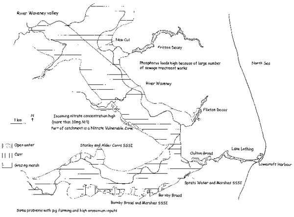
Fig. 16.28 State of the River Waveney valley.
Oulton Broad is much modified and connected to the Waveney by Oulton Dyke at one end and at the other, through locks, with Lake Lothing, which is linked to Lowestoft harbour. It is heavily developed with marinas and shoreline buildings, has turbid water and is influenced by effluent from the Waveney coming downstream from Beccles and Bungay and upstream from Breydon Water.
Finally, there are two long, thin Broads associated with small side streams along the stretch of river north-west of Lowestoft; Flixton Decoy and Fritton Decoy. Little is known of their limnology, but they appear to be eutrophicated by agricultural water and have statuses not unlike the Trinity Broads. Attention to nutrient flows in their catchments could pay dividends, for they have residual aquatic plant communities. Barnby Broad is likewise salvable, for it is nearly isolated, but there is little to be done about Oulton Broad short of major modification of the catchment. The river itself still retains quite diverse banks, doubtless affected by the nutrient levels, but less damaged by boat activity than those of the Bure and its tributaries.
Overview
The potential for lake and river restoration in Broadland is currently limited, but conceivably substantial. Significant progress can only be made by reduction of the nutrient sources from the whole catchment. It is increasingly likely that phosphorus sources from agriculture will need to be controlled and unlikely that stable diverse plant communities can be regained without control of nitrates from the catchment also.
There is also the unexpected to be considered. The facility and frequency with which people and boats and other forms of transport can now move between countries is increasing the problem of exotic species. The coypu was a very significant influence on Broadland until it was exterminated. Further alien species will turn up in the future. The small Asiatic clam, which forms dense beds that can filter large quantities of water and also build up masses of shell in a mucilaginous matrix that attracts sediment to it, has appeared in the River Chet and is extending its Broadland range. There is little chance of controlling it, for it spreads readily by tiny larvae and we have no concept at present of whether it will have profound ecological impacts or remain, like some other introduced species, a local curiosity. We shall also face extreme weather events as the atmosphere adjusts to a changing climate. We might expect severe winter floods, intense droughts, extreme gales. The effects of these can be pivotal. They might change entire landscapes to unpredictable extents and obviate all manner of previous restoration work or achieve more in a week than has been possible over a generation.
The underlying philosophies of restoration ecology also are changing and widening. Increasingly it is seen that merely restoring a chunk of vegetation to some target conjured from its past history is ultimately futile if the human society, with which the environment is linked, is not fully attuned to values that favour a less exploitative approach to natural resources. Some would even say that, in turn, this needs the individuals of that society to reappraise their own aspirations and values. A ruthless exploitation of resources is what is predicted from the behaviour of man as yet another animal; history gives us plenty of evidence for this and Broadland is no exception. The test for the future is whether humans can overcome their own innate natural history. Until then the future seems bleak for the natural history of Broadland in general. We shall have to be content with isolated nuggets of high quality in a bedrock of mediocrity.
Further reading
The art and science of restoring lakes ultimately needs a thorough grasp of the whole of limnology. The scope is large, the literature equally so. Firstly there are general works on restoration of fresh waters, including Ryding & Rast (1989), Cooke et al. (1993), Eiseltova (1994) and Moss, Madgwick & Phillips (1996). The latter is particularly relevant to the Broads (and very readable!). The restoration strategy on which this chapter hangs is detailed in it. Jeppesen et al. (1999) and Van der Molen & Boers (1999) give useful accounts of the approaches taken in Denmark and the Netherlands, two of several countries in Europe that take lake restoration very seriously.
Wilson (1999) and Wilson et al. (1995) consider the available legislation in the UK and Europe, and the Environment Agency (2000) presents an ‘official’ strategy for coping with eutrophication, which confirms most of the problems alluded to in this chapter. Recent reviews of nutrient problems include Ministry of Agriculture (1999), Johnes et al. (1996), Schindler (1978) and of the links between nutrient control and fish and zooplankton ecology, Carpenter & Kitchell (1994) and Moss et al. (1994). Shapiro (1990) is a stimulating review of what controls blue-green algal growth and Foy et al. (1995) was one of the first papers to indicate an increasing role for increased phosphorus release from agricultural soils.
Biomanipulation is now a very well-established technique and may be reviewed through Shapiro et al. (1975), Benndorf (1987), Hosper (1989), Moss (1992), Reynolds (1994) and Phillips et al. (1996). Giles (1992) is a very interesting case study of the restoration of gravel pits using biomanipulation. Irvine et al. (1990) explored the possibility of installing artificial substrates to simulate plant growth during the early stages of restoration, but found it to be practicably unworkable. As in many aspects of life, there is no substitute for the real thing. Hammer (1989) and Vought et al. (1994, 1995) give leads into the areas of constructed wetlands and buffer strips respectively. Van Donk & Gulati (1995) and Klinge et al. (1995) concern themselves with the restoration of small lakes in the Netherlands and discuss the issues of scale. Issues concerning sediment release and the efficacy of sediment removal are covered by Marsden (1989), Osborne & Phillips (1978), Phillips et al. (1994), Bjørk (1994), Annadotter et al. (1999) and Moss, Madgwick & Phillips (1996).
For studies on specific areas of Broadland, there has been a prolific recent literature, but there is still a lot of very valuable information effectively lost because it is in obscure semi-official documents and not in the formal scientific literature. Papers on the River Ant and Barton Broad include Osborne (1980, 1981) and Phillips et al. (1999). An account of recent developments is in Moss, Madgwick & Phillips (1996). Cromes Broad is discussed in Perrow et al. (1999) and Alderfen Broad in Moss et al. (1986, 1990), Cryer et al. (1986) and Perrow et al. (1994).
The acidification of Calthorpe Broad is documented in Gosling & Baker (1980). Papers on Hickling Broad and the upper Thurne include Holdway et al. (1978), Bales et al. (1993), Irvine et al. (1993, 1995) and Moss & Leah (1982), but the very recent events of the late 1990s, though well documented in unpublished reports, are not yet properly published. The report edited by Eaton (1999) is, however, available from the Broads Authority. Insights into Hickling ecology can be obtained from studies on comparable brackish lakes elsewhere (Moss (1994), Jeppesen et al. (1994), Simons et al. (1994)). Studies on Cockshoot Broad include Moss et al. (1986), Moss (1990) and Moss et al. (1996) and on the Bure in general, Moss & Balls (1989), Moss et al. (1989, 1991) and Clarke (1990). The Trinity Broads are dealt with in Clarke (1973) and Hameed et al. (1999). Information on the Yare and Waveney is less detailed, for restoration of these has not been seriously contemplated. George (1992) includes most of it. Baker & Lambley (1980) is a survey of the upper Wensum. The first published hints of a potential problem with the Asiatic clam came in a short ‘Wildlife report’ in British Wildlife, February 1999, p.207.
