Paxí (Páxos), the smallest of the seven main islands of the Ionian archipelago, is 90 minutes by conventional excursion boat from Corfu (Kérkyra) – half that time by hydrofoil. Hilly and green, it has rugged west-coast cliffs, several sea-caves and various pebble beaches. Paxí figures little in ancient history and mythology, when it was uninhabited, though Tim Severin’s The Ulysses Voyage identifies the Homeric spring and dell of Circe as the modern one beside the late Byzantine church of Ypapandí, in the far north. Paxí acquired extensive olive groves and served as a hunting reserve for the Corfiot Venetian aristocracy, but was only systematically populated during the 15th century. The gnarled olive trunks, their shimmering leaves like coins tossed in the breeze, are emblems of the island, and provided the main livelihood before tourism – Paxiot oil ranks among the best in Greece, and has won many international medals. Dwellings, from humble cottages to baronial mansions, are tucked into hollows out of sight, and out of reach of the maïstros, the prevailing northwest wind; only during modern times have villas with sea and coast views appeared.
All boats dock at the small capital, Gáïos 1 [map], arrayed fan-like around its main square and sheltered by the two islets of Agios Nikólaos and Panagía, sporting, respectively, a Venetian castle and small monastery. Gáïos preserves narrow streets and a few grand 19th-century buildings with Venetian-style balconies and shutters, plus most island shops, though tavernas are undistinguished.

Fishermen on Levkáda.
Britta Jaschinski/Apa Publications
Paxí’s single main road meanders northwest, through the olive groves and tiny hamlets consisting of a few houses, and perhaps a kafenío at main junctions. Locally sold walking maps point you along a maze of old walled paths, dirt tracks and paved lanes, which provide the best way to see the island. Reached by a side road, Longós on the northwest coast is the most exclusive resort, flanked by the popular beaches of Levréhio and Monodéndri, the latter with road access. The “motorway” ends at Lákka 2 [map], beloved of yachts and the majority of landbound tourists, with a better choice of food and lodging; a signposted path leads to Orkós beach.
The northeast coast of Andípaxi (Andípaxos) islet shelters the two excellent beaches of Vatoúmi and Vríka, well known to day-trippers in summer but idyllic off-season. Only in summer, when several tavernas operate, do a dozen people live here; Andípaxi’s vineyards produce a heavy red wine favoured for local festivals, and a lighter tawny white.
Agios Dionýsios in Zákynthos.
Phil Wood/Apa Publications
Levkáda (Léfkas)
Like Évvia, Levkáda is joined to the mainland by a swing bridge over a canal, opening on the hour to let yachts pass. Greeks seasonally crowd the place, glad to find an island exempt from the prices and weather-whims of a ferry crossing. Yet Levkáda feels like the Ionian, with standard Venetian influences on speech and cuisine, the imposing fort of Santa Maura by the bridge, plus spear-like cypress and bright yellow broom in May carpeting the steep hillsides. Kefaloniá may be higher, but Levkáda has a more rugged landscape, which has preserved rural lifestyles in the hill villages; older women still wear traditional dress, while local crafts and foodstuffs are avidly promoted.
Levkáda Town 3 [map] faces the canal and the lagoon enclosed by the Gýra sandspit; local topography provides safe mooring for numerous yachts on the southeast quay. Of all Ionian capitals, it’s the most pedestrian-friendly; much of the central area is off-limits to cars. The municipal axis is Ioánnou Melá, which beyond lively Platía Agíou Spyrídonos becomes Odós Wilhelm Dörpfeld, in honour of the early 20th-century German archaeologist who attempted to prove that Levkáda was in fact Homeric Ithaca. He is again duly revered in the excellent Archaeological Museum (Tue–Sun 8.30am–3pm), with well-labelled exhibits on ancient religion and daily life. Also notable are several ornate Italianate churches dating from the late 17th or early 18th century, where arched windows, artwork of the Ionian School and Baroque relief work sit oddly beside post-earthquake belfries modelled on oil derricks.

Lunch by the lagoon in Levkáda Town.
Britta Jaschinski/Apa Publications
Levkáda is the homeland of 20th-century poet Angelos Sikelianos, and Lafcadio Hearn, a 19th-century short-story writer who immortalised supernatural Japan, born here to Greek and Irish parents. There are cultural links between the island and Japan, and streets commemorate both men.
Heading down Levkáda’s east coast, the little port-resorts of Lygiá and Nikiána, with pebble coves and fish tavernas, are the first places to prompt a stop. They are calmer and quieter than Nydrí 4 [map], 20km (12 miles) south of Levkáda opposite a mini-archipelago of four islets. The view out to them is the reason Nydrí has been earmarked for package-tourist development, since local beaches are frankly mediocre. Until the 1970s it was a tiny fishing village, where Aristotle Onassis used to pop over for dinner from Skorpiós, his private island; there’s a statue of the man on the quay now named for him, but no trace of exclusivity lingers, and his granddaughter finally sold Skorpiós in 2013.
The one conventionally inhabited satellite island, Meganísi, accessible by at least four daily ferries, is an ill-kept secret; yachters already appreciate its quiet bays and attractive villages. The best escape for landlubbers lies 3km (2 miles) inland, where the Roniés Waterfalls prove surprisingly impressive, and indicative of abundant water at the heart of Levkáda.
Beyond Nydrí, Dörpfeld excavated extensively at Stenó, and is buried on the far side of Vlyhó bay. The island ring road curls past Mikrós Gialós pebble bay and Sývota yacht harbour before descending to Vassilikí 5 [map], 40km (25 miles) from town, one of Europe’s premier windsurfing resorts. Boat tours are offered around Cape Levkátas – where Sappho legendarily leaped to her death – to spectacular west-coast beaches, also accessible by roads of varying steepness. Southernmost Pórto Katsíki 6 [map] stars on every third postcard of Levkáda; Egremní and Gialós are less frequented, while panoramic Atháni village has the closest tourist facilities. Further on, Drymónas is the most architecturally preserved settlement on the island, while Kalamítsi has an eponymous beach and “shares” Káthisma, Levkáda’s longest strand, with Aï Nikítas. The only port actually on the west coast has become a relatively upmarket resort, though worth avoiding in peak season. Beyond Aï Nikítas’s own little beach, Pefkoúlia stretches north to the headland dividing it from Agios Ioánnis, the nicest section of Gýra beach, with its abandoned windmills.
Journeys inland thread through the half-dozen Sfakiótes hamlets occupying a fertile upland, where churches with Venetian-style belfries may be seen. The usual destination is Karyá, even higher and cooler, with a thriving crafts tradition and a vast central platía shaded by several giant plane trees.
The Odysseus Trail
Odyssean sites near Vathý, Itháki include the Bay of Phokrys (now Fórkynos), the Cave of the Nymphs, the Spring of Arethoúsa, and ancient Alalkomenae (Alalkoméni). Having landed at Phokrys, it is said, Odysseus climbed up to the cave and hid various gifts given him by King Alkinoös of the Phaeakians. Next, Odysseus met his loyal swineherd Eumaeos and son Telemakhos at the Arethoúsa spring; the track-and-path walk from Vathý takes 90 minutes, challenging but with good views. Alalkomenae occupies a hillside 5km (3 miles) west of Vathý, above the road between Fórkynos and the secondary port (and a good pebble beach) of Píso Aetós; Heinrich Schliemann excavated here, but most of the finds (now in Vathý’s museum) clearly do not date from the Homeric era.

Hiking Mount Énos, Kefaloniá.
Mockford Bonetti/Apa Publications
Ithaca (Itháki)
Evidence that Itháki actually was the ancient home of Odysseus, wandering hero of Homer’s Odyssey, is hardly conclusive, but this hasn’t discouraged a local Homeric “heritage industry”, with numerous streets and businesses named for characters in the epic, and modest archaeological sites assiduously signposted as putative locales for various episodes.

Vathý has retained a traditional style.
Mockford Bonetti/Apa Publications
Most ferries dock at the cheerful capital, Vathý 7 [map], occupying the head of a long bay. Though badly damaged by the 1953 earthquake, many buildings survived, while others were tastefully rebuilt with traditional architectural elements. There are more tavernas and kafenía, especially along the quay, than in any other port town of this size. Several pebble beaches – pleasant, if not Itháki’s best – lie close by; this is an island ideally sized for scooter exploration and walking.
Itháki is almost pinched in two by an isthmus barely wide enough for the main corniche road. The northern half has more lush vegetation and better beaches; below Léfki village the secluded pebble bays of Agios Ioánnis and Koutoúpi grace the west coast. Stavrós 8[map], 16km (10 miles) from Vathý, is Itháki’s second town, with another small museum devoted to finds from local sites with a better claim to being Odysseus’ possible home. These are a citadel on Pelikáta hill and, more intriguing, an excavation marked as “School of Homer” off the road to Exogí. Walls and foundations, a few Mycenaean graves, steps carved into the rock and a vaulted cave-well lie exposed. In size and position, the place feels just right to be the base of a minor chieftain like Odysseus. Exogí, the highest village on the island, is seasonally occupied but offers superb views northeast. From Platrithiás village a paved drive goes to Afáles bay with excellent sand-and-pebble patches, while another road loops through Agii Saránda and Lahós, partly spared by the earthquake, en route to Fríkes. There are morning ferries here (to Levkáda) and many yachts, although most visitors continue, past attractive pebble coves, to Kióni 9 [map], Itháki’s most upmarket resort, where again various houses survived the quake. At either port, accommodation is non-existent during high season.
From Kióni you can walk up the cleared and profusely waymarked old path to Anogí, a three-hour round trip; it’s the best hike on the island, with only the last 20 minutes spoilt by the heliport and its access road. In half-deserted Anogí, there’s a medieval church of Kímisis tis Theotókou (Dormition of the Virgin), with heavily retouched Byzantine frescoes and a Venetian belfry. Some 4km (2.5 miles) south, the Monastery of Katharón is by contrast a post-quake barracks-like structure, flanked by modern antennae, but the views are unsurpassed.
Eat
Kefaloniá is noted for its honey (thyme-scented), quince jelly and a local speciality called riganáta – feta cheese mixed with bread, oil and oregano.
Kefaloniá (Kefallinía, Cephalonia)
Kefaloniá is the largest and second most mountainous Ionian island, its population famous for a studied (often creative) eccentricity. It has mixed feelings about being typecast as “Captain Corelli’s Island”, since political opinions expressed in Louis de Bernières’s locally set blockbuster novel are not popular here.
The capital town of Argostóli ) [map], levelled by the 1953 earthquake, was rebuilt in utilitarian style and has a workaday feel, epitomised by meat and produce markets perched right on the commercial quay near the pedestrian-only, British-built Drápano stone bridge across the lagoon. The quay’s names honour two islanders: Ioannis Metaxas, 1930s dictator and defier of the Italians, and Andonis Tritsis (1937–92), innovative architect, maverick politician and ultimately mayor of Athens. The heart of town is the 2016-revamped Platía Vallianoú, ringed by hotels, kafenía and pest-resistant palms; trendy cafés have sprouted on the pedestrianised, relatively elegant Lithóstroto beside smart shops. Specific sights are limited to three museums, of which the Korgialenios Historical and Folkloric Museum (Ground floor of Korgialénios library; closed until further notice) is the most interesting. It offers, should it re-open, archival pictures of Argostóli pre- and post-quake, and thorough coverage of traditional life. Northwest of town, near the Doric rotunda of Agios Theodóros lighthouse, the “sea mills” at Katavóthres used to grind grain and generate electricity; salt water pouring down sinkholes here emerges three weeks later near Sámi, but the 1953 disaster reduced the flow to a trickle.

Looking out from the Agios Theodóros lighthouse.
Mockford Bonetti/Apa Publications
To the east looms Mount Énos ! [map] (the ancient Ainos), at 1,628 metres (5,340ft) the highest peak in these islands and still partly covered with native firs (Abies cephallonica); two small reserves protect the remaining trees, much reduced by fires and loggers. The inclined south coastal plain at the base of the mountain, Livathó, is punctuated by a conical hill bearing the Venetian capital of Agios Geórgios, inhabited from Byzantine times until the 17th century. The impressive summit castle (Tue–Sun 8.30am–3pm, may close off-season) has wonderful views. Aristocratic associations linger at certain Livathó villages: pre-quake stone walls enclose vast estates; Lord Byron lived at nearby Metaxáta in 1823; and Keramiés still harbours dilapidated pre-quake mansions and a huge olive mill. The largest beach in the area, with resort amenities, is Lourdáta.
On the west shore of Argostóli gulf, reached by frequent ferries used by drivers and pedestrians alike to avoid the tedious journey by road, Lixoúri has long been eclipsed by rival Argostóli, but it’s a pleasantly sleepy town with views to Zákynthos. Beyond, southwest on the peninsula, lie the busy red-sand beaches of Mégas Lákkos and Xí; en route you’ll see how the fertile, grain-and-grape-planted terrain was heaved and buckled by the force of the quake. Beyond Xí, Kounópetra (Rocking Stone) no longer does so since 1953. Northwest of Lixoúri is the long, fine-pebble beach of Petáni, exposed but spectacular, although much the best beach near Lixoúri is the lonely, and facility-less, Platiá Ammos, reached by 300 steps from near Theotókou Kipouríon monastery.
Northern Kefaloniá was less damaged by the earthquake, and surviving medieval houses in various states of repair, especially at Vassilikiádes and Mesovoúnia, serve as poignant reminders of a lost architectural heritage. But the port resort of Fiskárdo @ [map] emerged almost unscathed, and ruthlessly exploits the fact despite a lack of beaches. The atmosphere is very pukka, if not precious, and yachts congregate in force, dodging the occasional ferry to Levkáda or Itháki. “Fiskárdo” is a corruption of the name of Norman-Sicilian adventurer Robert Guiscard, who made Kefaloniá his headquarters, but died near Lixoúri in 1085.
On the west coast, the perfect horseshoe harbour of Assos £ [map] sees only fishing boats and is the better for it; there’s good swimming from the isthmus joining this partly preserved village to a pine-covered bluff, with its fine late 16th-century Venetian fort. A bit further south, Mýrtos is among the most famous – and overrated – beaches in the Ionians: coarse-pebbled and downright dangerous if a surf is up.

Peering down over the partly exposed lake of Melissáni cave.
Mockford Bonetti/Apa Publications
The water is calmer and the pebbles smaller at Agía Evfimía, a fishing village on the east coast; between here and the functional ferry port of Sámi lies the Melissáni cave $ [map] (daily May–Oct 8am–7pm, Nov–Apr Fri–Sun 10am–4pm), containing an underground lake with its roof partly open to the sky. Nearby, another cave, Drogaráti (Apr–Oct daily 9am–8pm) offers multicoloured stalactites and stalagmites, and is the occasional venue for concerts.
Beyond Sámi, a good road threads attractively through vegetated scenery to underrated Póros, another ferry/yacht port with a backdrop of green cliffs. From here you loop around the coast to busy Skála, with its superb sand-and-gravel beach fringed by pines, and extensive mosaic flooring in a Roman villa (unreliably open; free), and then around Cape Moúnda to the all-sand Kamínia beach, Kefaloniá’s principal turtle-nesting venue.
Zákynthos (Zánte)
Zante, Fior di Levante (flower of the East), said the Venetians, and its central plain – the most fertile in the Ionians – and eastern hills support luxuriant vegetation. The southeastern coasts shelter excellent beaches: some are almost undeveloped, others are home to notoriously unsavoury tourism.
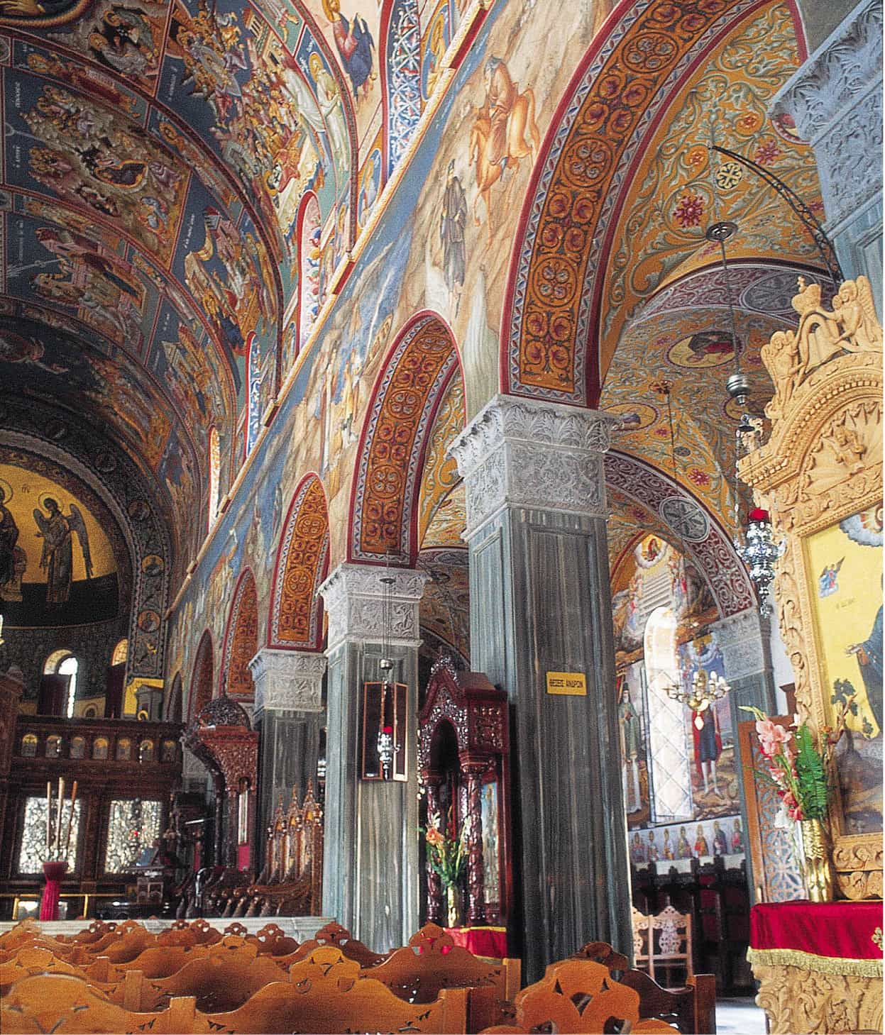
At the once-elegant harbour town of Zákynthos % [map], ferries dock by Platía Solomoú, named for native son Dionysios Solomos, a 19th-century poet who wrote the words to the Greek national anthem. At the rear of his platía, the Zákynthos Museum of Post-Byzantine Art (Tue–Sun 8.30am–3pm) features icons rescued from quake-blasted churches, as well as numerous 17th–19th-century religious paintings of the Ionian School, founded by Cretan artists fleeing the Ottoman conquest, who met local artists strongly influenced by the Italian Renaissance. At the southern end of the harbour is the cathedral of Agios Dionýsios (daily 8am–1pm and 5–10pm), the island’s patron saint, designed in its latest incarnation by the archaeologist and Byzantinologist Athanasios Orlandos. The stained glass was donated after the 1953 earthquake by the island’s small Jewish community in gratitude for being hidden from the Nazis by their fellow islanders.
In medieval times people lived above the present town in Bóhali district, inside the huge kástro (Tue–Sun July–Oct 8am–7pm, Nov–June 8.30am–3pm), which is mostly Venetian on Byzantine foundations. Nearby, several cafés provide superb views.

Shipwreck Bay, Zákynthos.
Dreamstime
Unfortunately, most of the 700,000 annual visitors don’t stray far from adjacent Laganás/Kalamáki ^ [map] beach resorts, whose explosive growth since the late 1970s is endangering the survival of loggerhead turtles , which have nested here for millennia. Luckily, the tourist tat is easily skirted, and Zákynthos shows its best side in the more remote corners. The Vasilikós peninsula, lying beyond forgettable Argási, has the island’s best, most scenic beaches, culminating in Agios Nikólaos and Gérakas, nearest the easternmost cape.
Start a tour of the unspoilt western hill villages from Kerí at the far south cape, with its lighthouse; next stop would be Kilioméno & [map], which survived 1953 largely intact. Tourists are coached to Kambí to watch the sunset, but Éxo Hóra and Mariés have more character, with pre-quake churches and wells, vital in this arid region. Still further north, Anafonítria village offers an eponymous 14th-century monastery with a daunting gate-keep; plaques recall the local legend that 1578–1622 abbot St Dionýsios forgave and sheltered his brother’s murderer here. Nearby, the 16th-century monastery of Agios Geórgios ton Krimnón has a round lookout tower in its well-tended courtyard; just beyond is the overlook for Shipwreck (Navágio) Bay * [map], the most photographed in the Ionians, where a rusty freighter – driven ashore in 1980 by the coastguard in the mistaken belief that it was a smugglers’ ship – lies half-buried in sand. Boat trips, the only access, visit from Pórto Vrómi, below Mariés.
From “Shipwreck”, head east through grain fields, and the two Volímes villages noted for their honey, textiles and cheese, to reach the east coast near Makrýs Gialós pebble beach and the bleak port of Agios Nikólaos, with daily summer morning ferries to Kefaloniá and excursion boats to the Blue Caves ( [map] – interconnecting grottoes with spectacular light effects at the right hour.
Back towards town, you wind through Alykés (the calmest beach resort), past secluded bays favoured by Greeks, before hitting mass tourism again at Planós.
Turtles vs. tourists
The survival of the loggerhead turtles of Zákynthos is under threat from some of the undesirable effects of mass tourism.
A loggerhead turtle crawls out of the sea onto the moonlit beach of her birthplace, the island of Zákynthos. She has crossed the Mediterranean to return, at last, to this spot. Summoning all her strength, the 90kg (200lb) reptile selects a place in the sand where she digs a nest with her rear flippers. In it she lays about 100 soft eggs, each the size of a ping-pong ball, covers them with sand and returns exhausted to the sea to rest in the shallows. However, the survival of the loggerhead (Caretta caretta) is endangered before she even reaches the beach. It has been estimated that nearly half the females basking in the shallows may be maimed or killed by the propellers of speedboats taking waterskiers and paragliders out to sea. Carelessly discarded litter creates another hazard, as turtles suffocate trying to swallow plastic bags that they mistake for jellyfish, a favourite food of theirs.
For the female turtle, hazards increase when she slips ashore. Disorientated by the glittering lights of hotels and the strange noises coming from the tourists and bars, she may scurry back to the surf-line, uncertain where to deposit her eggs. Those that try to continue their labours may suffer the indignity of ignorant spectators brandishing torches and flashing cameras, frightening the turtles back into the sea where the eggs may be released, never to hatch.
Eggs that are successfully laid are often crushed by thoughtless quad-bikers, horse-riders and motorists who drive across the sand, which also compacts it so that it is impossible for the hatchlings to emerge. Beach umbrellas are unwittingly driven into nests, piercing the eggs. Tamarisk trees, planted to shade sunbathers, pose another problem, as hatchlings become tangled up in the roots. Even sandcastles may create holes that become shallow graves for the young turtles.
Hatching time
Hatching takes place from early August to late September – precisely when most tourists arrive. The 6cm- (2.5in-) long hatchlings may emerge from their hazardous 50-day incubation and, instead of heading instinctively to starlight on the horizon line at sea, frequently wander confused up the beach to hotel and bar lights – an error that brings death from exhaustion or dehydration.
Zákynthos formerly had one of the greatest concentrations of nesting turtles in the Mediterranean. Laganás Bay was a particularly favourite spot but, confused by the combination of boats, lights and noise that tourism has brought, the turtles have abandoned these busy sands. The majority now nest in the more secluded beaches of Sekánia, Gérakas and Dáfni, where there is barely room for the activities of the bewildered reptiles. Fewer than 650 turtles now breed annually on Zákynthos, as against over 1,200 during the early 1980s.
Protecting the turtles
The Greek Sea Turtle Protection Society (www.archelon.gr), locked in frequent, sometimes violent conflict with unscrupulous developers, midwifed the 1999 creation of the National Marine Park of Zákynthos (www.nmp-zak.org), encompassing the whole gulf between the capes of Gérakas and Kerí. Three levels of control restrict boating and land access; all affected beaches have dusk-to-dawn curfews. Volunteers are on hand during the season to help inform visitors, and monitor nests.

The National Marine Park of Zákynthos was set up to protect nesting turtles.
Dreamstime