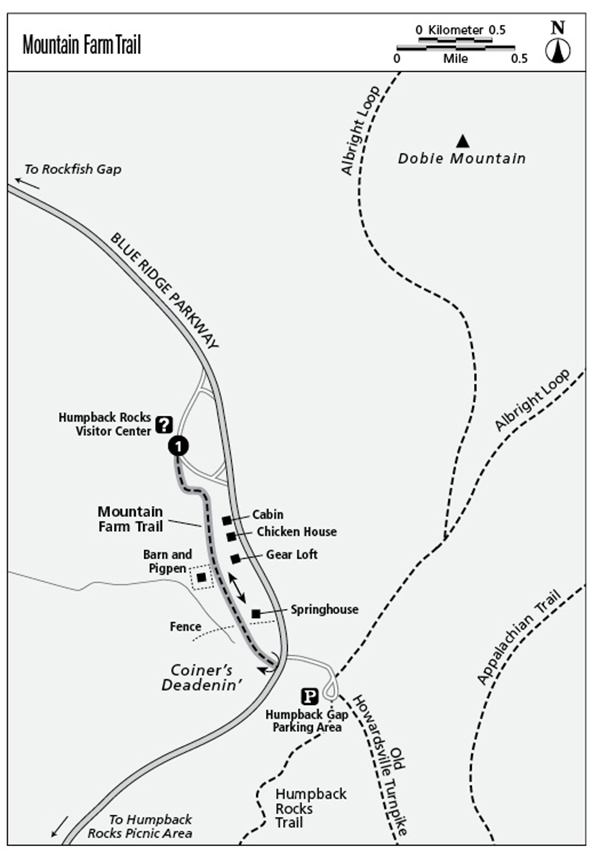
1 Mountain Farm Trail (Milepost 5.8)
This trail offers an eye-opening glimpse into the rustic lives led by nineteenth-century Appalachian mountaineers who lived near what is now the Parkway.
Parkway milepost: 5.8
Distance: 0.5 mile out and back
Elevation gain: Negligible
Maps: USGS Sherando; Parkway map available at visitor center or www.nps.gov/blri/planyourvisit/brochures.htm
Finding the trailhead: Park at the visitor center and take the paved sidewalk south (left when facing the building).
The Hike
What a difference a century or so makes. The cabins and outbuildings of the re-created William J. Carter farm—not to mention seasonal programs and costumed interpreters—give startling insight into the lives of Appalachian mountaineers. This pioneering lifestyle still existed in some places when the Blue Ridge Parkway was built in the mid-1930s. The 1890s farm found on the Mountain Farm Trail isn’t the original; it was re-created in 1950 using period structures. Nevertheless, it is an authentic setting explored by a very easy trail.
Buy the trail’s inexpensive brochure at the visitor center and take the paved sidewalk that becomes a gravel lane (likely a section of a historic old turnpike you’ll encounter on a loop of Humpback Rocks). On the left, you first reach a cabin and chicken house and then a “gear loft,” where the family stored their “plunder” (supplies and equipment). Past those structures and across the lane, a contorted barn is surrounded by a stone-walled pigpen. Farther on, a springhouse channels cold water through a sheltered food storage structure. Beyond that is “kissin’ gate”; pass through and you’re in “Coiner’s Deadenin’,” grass-covered meadows under the towering crag of Humpback Rocks. Here mountaineers cleared fields the slow way—by girdling the trees to kill them and planting crops between the leafless giants (which were later felled).
You can walk beyond the gate, gradually rising to Humpback Gap and trailhead parking for the Humpback Rocks Trail on the opposite side of the Parkway. Retrace your steps, or park at Humpback Rocks trailhead and take both trails from one central spot.
The steep trail to Humpback Rocks lifts hikers to truly awe-inspiring vistas that stretch north and south along the Blue Ridge, east to the Piedmont, and west into the Shenandoah Valley. It’s a 1.0-mile climb on a blue-blazed trail that, though strenuous, has a partially gravel surface and resting benches along the way. When the gravel trail levels off at the top of a long uphill section, do not turn left—stay straight to be sure you’re on the formal trail. That trail climbs wood and stone steps to a sign at the top where a left leads to the rocks. Past this sign, be sure to continue bearing left to reach the rocks—informal paths wander everywhere in this area. As you exit the rocks and re-enter the woods, bear to the right back up to the sign and the trail you came in on (it is easy to be drawn left and downhill on an old route that is sure to get you lost).