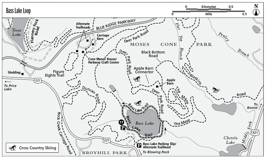
17 Bass Lake Loop (Milepost 294.6)
This hike is a circumambulation of Moses Cone Park’s prettiest lake.
Parkway milepost: 294.6
Distance: 0.8-mile loop from the lakeshore parking lot; 1.6-mile loop from US 221 trailhead
Elevation gain: Negligible
Maps: USGS Blowing Rock; Parkway map available online at www.nps.gov/blri/planyourvisit/brochures.htm and seasonally at Cone Manor House/Parkway Craft Center
Finding the trailheads: Exit the Parkway at Milepost 294.6 to US 221. Turn left and descend in about a mile to the Bass Lake entrance and its two trailheads. The first is a left turn into a paved road that drops to a parking area on the banks of Bass Lake. Just beyond that turn, also on the left, the roadside Bass Lake parking slip is usable when snow complicates access to the lakeshore parking area.
The Hike
This is an easy, extremely scenic loop that, although unpaved, might be suitable for wheelchairs in dry weather. The Bass Lake loop is easiest from the lakeshore parking area below US 221.
Take a right—or left—out of the lot; there really isn’t a preferred direction (this description goes right). The grade weaves in and out along the grassy lakeshore amid maples and reaches a junction right at 0.2 mile—the 0.4-mile side trail to the parking slip on US 221.
Head left across the dam with the Cone Manor House visible well above the lake. Across the dam, keep left as The Maze trail bears right. Cross a span over the lake’s outlet, and then a second road goes right (part of a circuit hike up to the Cone Manor House). In the area where the second carriage road veers right, you may notice the stone base of a boathouse down on the lakeshore at about 0.3 mile.
Continue left around the lake; your parking area is visible beyond an island on the opposite shore. The trail turns right and then left around the upper end of the lake where a bridge crosses the inlet brook at 0.6 mile. There’s another bridge soon after, where hikers with dogs step off the trail to give them a drink. From here it’s a few hundred feet back to the parking area for an 0.8-mile loop.
Starting at the parking area on US 221, hikers pass an iron gate and gradually descend about 0.1 mile to a T junction with Duncan Road. The access road to the lakeshore parking area is just to the left, and a sign indicates that the Manor House is 2.6 miles in that direction across the access road. (Heading left here across the road takes you on the 4.6-mile circuit hike to the manor that returns to the lake at the spot mentioned above.) Bearing right, reach the lake 0.4 mile from your car. Turn right to cross the dam. The added access distance makes this a 1.6-mile loop.

Key Points from Lakeshore Parking
0.2 Bear left where road goes right to US 221.
0.3 Keep left across dam; avoid two roads to the right.
0.6 Major inlet brook feeds Bass Lake.
0.8 Arrive back at lakeshore parking area.