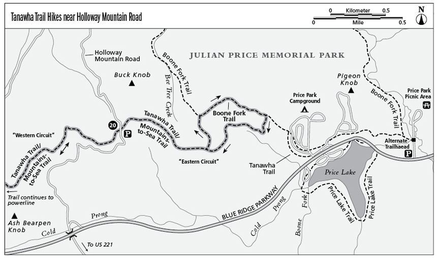
20 Tanawha Trail Hikes near Holloway Mountain Road (Milepost 298.6)
Two opportunities—a circuit hike and an out-and-back walk—sample the Tanawha and Mountains-to-Sea Trails in an area noted for outstanding meadow views.
Parkway milepost: 298.6
Distance: 2.4 miles for the circuit to the east of the road; 1.6 miles for the out-and-back hike to the west
Elevation gain: 50 feet
Maps: USGS Grandfather Mountain; Parkway map available online at www.nps.gov/blri/planyourvisit/brochures.htm and in season at Linn Cove Information Station/Visitor Center (Map does not show the hike described first below; rely on the map provided here)
Finding the trailhead: Leave the Parkway south of Blowing Rock at Milepost 298.6—the Holloway Mountain Road–US 221 exit. Turn immediately right onto the dirt road and park on the right in 1 mile at the Tanawha Trail crossing.
The Hikes
Eastern Circuit
The circuit hike to the east patches together an easy sampling of the Tanawha, Boone Fork, and Mountains-to-Sea Trails without requiring you to completely retrace your steps. It also takes hikers along one of the premier unpaved roads near the Parkway. If you continue 1.2 miles past the trailhead and then turn right onto a paved road, you soon reach NC 105 between Boone and Banner Elk, which makes this the perfect back way into the High Country.
Head through the fat-man squeeze going north (to the right coming from the Parkway) on the combined Tanawha/Mountains-to-Sea Trail. Cross the first stretch of meadow, pass through another squeeze at 0.1 mile, and then turn right onto an old gravel farm road. Follow the grade a short distance beneath a power line at 0.3 mile; at 0.4 mile veer left up the log steps as the trail leaves the grade. At 0.5 mile cross the next fence and pass a Tanawha Trail signpost just beyond it onto another obvious gravel road grade.
Two hundred feet beyond the sign, at about 0.6 mile, the trail goes right on the main grade near the edge of a meadow. Leave the formal trail here, veering uphill where the road grade rises left. Emerge into the meadow and follow the obvious but faint, now-grassy old roadway left for 100 feet parallel to rhododendron at the edge of the woods. It wanders across the meadow, under the power line in the distance, and to the right of the rise beyond.
At about 0.9 mile the grade reaches a junction where the Boone Fork Trail comes in on the left. The junction is marked by a Mountains-to-Sea Trail signpost and signs in two directions reading BOONE FORK TRAIL, 4.9-MILE LOOP. Keep straight; the Boone Fork Trail turns left at the sign and onto your road grade.
Follow the rhododendron-arched Boone Fork Trail straight ahead, or turn right at the sign on an obvious secondary path and go up over the grassy bulge of the meadow for a great view of Grandfather Mountain. Continuing over this meadow, head off the steeper side of the peak and down to the Boone Fork Trail, visible below as it leaves the rhododendron tunnel you avoided and arcs to the right across the field below.
Returning to the main trail, descend from the meadow into white pines to a junction at 1.3 miles. This is the Mountains-to-Sea/Tanawha Trail combination that you started on but left back at the meadow. Turn right off the Boone Fork Trail and head south along this section of trail you missed.
The first few hundred yards are beautiful—ferns, moss, and pine needles cover the ground under a grove of white pines. Notice the forgotten ruin of a tiny chestnut farm structure on the left as you start down from the turn. The path crosses a bridge, meets a fenceline, follows it, crosses another small bridge, and gradually climbs right to reenter the meadow at an old apple orchard. Leveling off, the trail switchbacks left and passes a grove of white pines flanked by another apple orchard—a long-ago mountaineer homesite. The trail swings past the site and enters the woods at a trailside pit where an underground stream threatens to collapse the path.
Heading back into the woods at 1.8 miles, you immediately pass the uphill grade you earlier took to the left to exit the formal trail (now on your right). Now you’re heading back the way you came. If you miss the last left turn from the road grade onto the Tanawha Trail to your car, don’t sweat it. The gravel roadway empties onto Holloway Mountain Road 200 feet beyond where you parked (turn left), for a total hike of about 2.4 miles.
Key Points
0.4Veer left off the grade and up log steps.
0.9Join Boone Fork/Mountains-to-Sea Trail.
1.3Turn right onto Mountains-to-Sea/Tanawha Trail.
1.8Rejoin portion of trail you’ve already walked.
2.4Holloway Mountain Road.
Western Circuit
Just across Holloway Mountain Road from the hike above lies an even easier meadow walk to the west and south. The Tanawha Trail heads toward Grandfather Mountain, and views of the peak dominate the horizon in that direction.
The trail leaves the road through the fat-man squeeze, turns left at the roadside Tanawha Trail mileage sign, and arcs up the edge of the meadow. The path crosses another fence at 0.4 mile below an old cemetery that is just out of sight on the high right. The trail swings into the bowl of the next meadow and then wanders through a grove of white pines with views down on Holloway Mountain Road.
When you reach a power line toward the end of the meadow at about 0.8 mile, a return from there creates an easy, meadow-filled stroll of 1.6 miles that’s perfect for a picnic or cross-country ski tour.