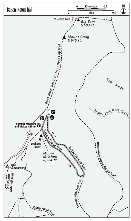
27 Balsam Nature Trail (Milepost 355.3)
The Balsam Nature Trail is a self-guided interpretive trail that explores the spruce-fir forest and deforestation caused by acid rain.
Parkway milepost: Reached from Milepost 355.3
Distance: 0.8-mile loop
Elevation gain: Negligible
Maps: USGS Mount Mitchell; rudimentary state park map available at summit facilities
Finding the trailhead: Take NC 128, the state park access road from Parkway Milepost 355, and go all the way to the Mount Mitchell summit parking area. Walk past the concession stand/museum on the ascending paved trail toward the summit tower. Go left when the Old Mitchell Trail branches right and then take the next left for the Balsam Trail. (A right leads to the new, wheelchair accessible summit tower—and a not-to-be-missed view.)
The Hike
Mount Mitchell—the highest peak east of the Mississippi—is a crowning part of the Blue Ridge Parkway experience. The 1,700-acre Mount Mitchell State Park—North Carolina’s first state park—clings to the highest peak of the Black Mountains and dominates the western skyline of North Carolina.
The story of how Mount Mitchell was named and measured involves considerable controversy. Although Connecticut native Elisha Mitchell is acknowledged as the first to measure the peak, Thomas Clingman, a North Carolinian, congressman, and senator, also claimed that he had been first. The debate went on for years until Mitchell returned to the peak and died in a slip from a waterfall. That swayed the public to Mitchell’s side, and he was buried on his namesake summit in 1858. His grave still lies below the summit tower.
The white triangle–blazed Balsam Nature Trail explores Mitchell’s mountain—the highest, most Northern climate in the South. The recently improved interpretive path has trailside exhibits that feature the ecosystem, climate, and plants and animals that live in this rarefied evergreen zone only found this far south at elevations above 5,500 feet. The pollution-induced dieback of the forest here is one topic tackled on the trail and in the mountain’s recommended museum.
The dying trees have returned this forest to the early stages of succession one might expect to discover after a forest fire or clear-cutting. Early research had blamed the destruction of the mountain’s evergreen zone on an infestation by the balsam woolly adelgid, a pest introduced into the United States around 1900. More recent studies suggest damage by acid rain—highly acidic precipitation that upsets the pH balance of the soil, freeing heavy metals that inhibit a tree’s ability to ingest nutrients.
The latest research suggests that airborne pollution from upwind utilities and industries leads to startlingly high ozone levels on Southern summits. Such pollution, often contained in cloud caps as acidic as vinegar, burns the needles of firs, dramatically inhibiting the growth and survival of evergreens already fighting a severe climate. The result is the stark tree skeletons of Fraser fir and red spruce that stand tall and gray in ghostlike groves. The Balsam Nature Trail is an introduction to this ongoing ecological catastrophe.
In addition to the evergreen Fraser fir and red spruce, prevalent deciduous species at this elevation include mountain ash. Among other plants are many found in New England—hobblebush and mountain wood sorrel, or oxalis, a cloverlike ground covering associated with boreal forests. It blooms in late May and early June. The rhododendron blooms in late June. Yellow birch seen here also grows north to Minnesota and Quebec.
The first leg of the trail passes Camp Rock, an east-facing shelter ledge used by explorers as early as 1850. The damp seeps at similar outcrops along the trail are favored growing sites for the purple turtlehead, a snapdragon-like flower. There’s a view north along the Black Mountain range. Mount Craig is the dominant, nearer summit just beyond the parking lot.
In addition to the yellow birch found on the trail, you might notice a grove of mountain paper birch, similar to the white-barked birches so often associated with New Hampshire and Vermont. The small heart-shaped leaves are the giveaway. If, as some scientists speculate, this grove is actually a separate species of birch, then only about 400 specimens exist, all within this state park.
The Balsam Nature Trail turns back left where the Old Mount Mitchell Trail goes straight to descend Commissary Ridge to Black Mountain Campground. This area is home to the most severe winter weather in North Carolina. In two days during March 1993, the mountain received a record 50 inches of snow. The trail passes a nearby stream that is likely the highest spring in eastern America. Its average temperature (when not frozen in winter) is 36 degrees Fahrenheit. About 100 yards beyond the turnoff, the nature trail ends at the summit parking lot.
For a longer walk, leave from the opposite end of the parking lot and take the orange-blazed Deep Gap Trail (the first part of the Black Mountain Crest Trail that leads toward Deep Gap) to Mount Craig for spectacular views back to the tower on Mount Mitchell. From here the size of the summit development shrinks and the mountain you conquered by car gains in stature. It’s a 2.0-mile moderate out-and-back day hike, with 535 feet of total elevation gain.
Key Points
0.1Old Mount Mitchell Trail goes right.
0.2Tower Trail goes right.
0.6Balsam Nature Trail turns left from Mount Mitchell Trail.