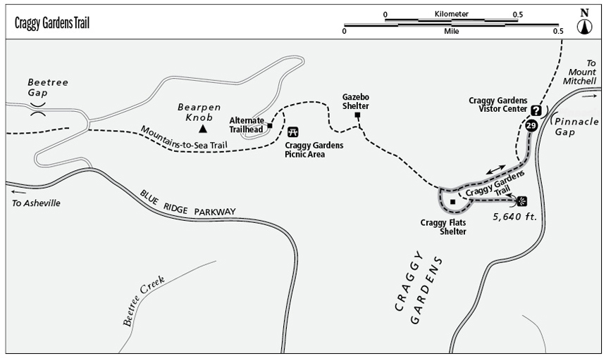
29 Craggy Gardens Trail (Milepost 364.5)
Great views from spectacular mountaintop balds recommend two Craggy Gardens hikes of different lengths.
Parkway milepost: 364.5
Distance: 0.8 mile out and back from the visitor center; 1.2 miles out and back from the Craggy Gardens Picnic Area
Elevation gain: About 145 feet
Maps: USGS Craggy Pinnacle; Parkway map available online at www.nps.gov/blri/planyourvisit/brochures.htm and in season at visitor center
Finding the trailhead: Craggy Gardens Visitor Center is on the Blue Ridge Parkway at Milepost 364.5, about 20 miles north of Asheville. The Craggy Gardens Trail begins on the south side of the visitor center.
A second trailhead is located west of the visitor center in the Craggy Gardens Picnic Area. To reach it, turn from the Parkway onto the unpaved Stoney Fork Road at Milepost 367.6. Take the next right into the picnic area and go to the end of the parking area.
The Hike
The Craggy Gardens Trail dips into the woods and the Mountains-to-Sea Trail goes right at 0.1 mile. Beyond, the path climbs gradually through a marvelously cylindrical rhododendron tunnel. This first section of the hike is a self-guiding nature trail, with resting benches and signs identifying plants.
The trail leaves the woods and levels out at grassy Craggy Flats at a rustic, recently restored picnic shelter built by the Civilian Conservation Corps (CCC) in the 1930s. Side trails to the left just before and after the shelter lead across the wind-whipped grasses of the balds to a view from a stone observation platform at 5,640 feet. Retrace your steps and the round-trip from the Parkway to the summit viewpoint and back is about 0.8 mile.
The main trail continues right through the shelter and descends to the Craggy Gardens Picnic Area.
For a longer walk of just more than 1.0 mile, start in the Craggy Gardens Picnic Area. The trail climbs gradually and at about 0.3 mile passes a short leftward trail that leads to a view from a gazebo shelter. From this direction the rustic old picnic shelter at Craggy Flats is about 0.5 mile. The round-trip, including the summit, is about 1.2 miles.
Whichever route you choose, the grassy crest offers spectacular views. Vistas from the meadows near Craggy Flats picnic shelter look north to hikers atop Craggy Pinnacle (5,892 feet, left) and Craggy Dome (6,085 feet, right). The observation platform looks south over Craggy Knob (5,600 feet) and the Asheville Watershed’s huge reservoir. Keep either of the two shelters in mind if the weather threatens (as it can quickly at this elevation).
Key Points
0.3Left turn at Craggy Flats picnic shelter.