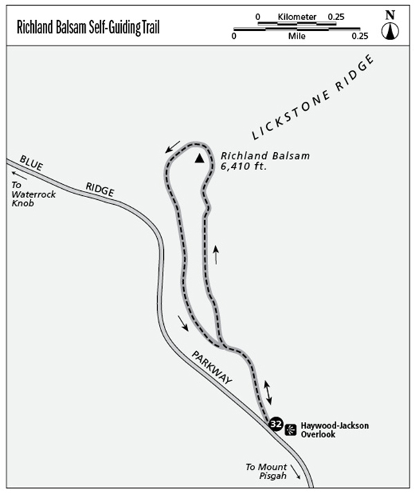
32 Richland Balsam Self-Guiding Trail (Milepost 431.0)
Numbered posts keyed to an interpretive brochure describe the changing composition of a lofty spruce-fir forest at 6,410 feet—the highest elevation reached by a Parkway trail.
Parkway milepost: 431.0
Distance: 1.4-mile loop
Elevation gain: 390 feet
Maps: USGS Sam Knob; no Parkway map
Finding the trailhead: The trail starts at the Haywood-Jackson Overlook (named for the boundary of the two counties), 9.2 miles south of NC 215.
The Hike
Here’s an oddity—a rooty trail a lot like the backcountry tracks that wind everywhere in western North Carolina’s national forests. The Richland Balsam Trail is the perfect counterpoint to the Parkway’s generally groomed paths. It’s a reminder that nature’s “beauty” can be untidy and unkempt—and more real in its roughness. And it’s also the Parkway’s best path to experience the aromatic lushness of the dripping, cloud-dampened spruce-fir forest.
Before you start your hike, enjoy the fine view of the Shining Rock Wilderness on the overlook’s skyline. Prominent peaks run from Cold Mountain on the left to the gentle pyramid of Mount Pisgah, the white-quartz summit of Shining Rock, and on to Devil’s Courthouse on the far right.
Just up the paved first 100 yards of the trail is a brochure box with laminated trail guides to borrow for your hike. The theme here, as it is at Mount Mitchell State Park’s Balsam Nature Trail, is a Fraser fir forest in decline. The brochure’s twenty-plus interpretive stops explore the topic.
Go right after the pavement ends at the first two of many benches, these in a tiny clearing where the loop splits. The trail passes an odd mileage sign (3,100 FEET TO THE SUMMIT) and then winds around through dense summer growths of sedge grasses and briers.
The trail passes rich evergreen zone vegetation and a sign reading 1,600 FEET TO SUMMIT. It rises over a series of small peaks to a bench at 0.6 mile, where the summit sign reads 6,410 feet. The path drops off the back of the peak, descending flights of stone steps amid evergreens and grasses. The evergreen needle–carpeted trail levels off and glides through a very scenic fir forest full of ferns.
A faint side trail goes right to the top of the road-cut with views of the Richland Balsam Overlook, the next view south on the Parkway (highest point on the motor road). You’ll pass another few benches at 1.2 miles, the second with the trail’s best view—a look along the Parkway to Cowee Mountain Overlook, the next overlook heading north. The trail passes through more spruce forest and ferns to the loop junction and a right back to the parking area at about 1.4 miles.
Even on a warm dry day, the summit shade is cool, which explains the seemingly drunken bumblebees fighting to do their summer duty amid the gusty chill. It’s that evergreen forest feeling that recommends this trail. If that feeling, and not the summit is your goal, just go left when the loop starts for a short, easy, and atmospheric out-and-back walk to the last few benches. (Oh . . . don’t forget to return your brochure to the box.)
Key Points
0.2Loop branches; go right.
0.6Summit bench.
1.2Bench with good view.
1.3Loop returns.
1.4Parking lot.