15
Shrader–Weaver Woods Nature Preserve
Shrader–Weaver Woods Nature Preserve is a refreshingly surprising place. Located in the pool-table-flat farm country of northwestern Fayette County, it looks from the outside like any other of the small, fragmented, flat woodlands that checker the Indiana countryside. Step foot inside, however, and it’s like stepping back into the ancient hardwood forest that once covered the state. The 108-acre preserve is home to some outright impressive trees, including what very well might be the best example of old-growth black walnut anywhere.
Start: From the small parking lot off Fayette CR 450W
Distance: 1.9-mile double loop
Hiking time: 1 to 1.5 hours
Difficulty: Easy
Trail surface: Natural surface singletrack
Best season: Late Apr to early May, during wildflower season
Other trail users: None
Canine compatibility: Leashed dogs permitted
Fees and permits: None
Schedule: Open daily from dawn to dusk, year-round
Maps: No trail map available. DeLorme: Indiana Atlas & Gazetteer: Page 47 A7
Trail contacts: The Nature Conservancy, 1505 N. Delaware St., Suite 200, Indianapolis, IN 46202; (317) 951-8818; www.nature.org/indiana. The Indiana Department of Natural Resources, Division of Nature Preserves, 402 W. Washington St., Room W267, Indianapolis, IN 46204; (317) 232-4052; www.in.gov/dnr/naturepreserve
Finding the trailhead: From Indianapolis, take I-70 east. At exit 131 for New Lisbon, turn right onto Wilbur Wright Road. Follow Wilbur Wright Road for 2.8 miles south to US 40, and turn left onto US 40. After 1 mile, turn right onto Fayette CR 550W. After 3 miles, turn left onto Fayette CR 700N. After 1 mile, turn right onto Fayette CR 450W. Drive until you see the SHRADER–WEAVER WOODS sign and parking lot on the right, about 1.75 miles south of Fayette CR 700N. GPS: N39 43.207' / W85 13.348'
THE HIKE
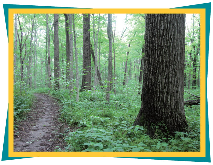
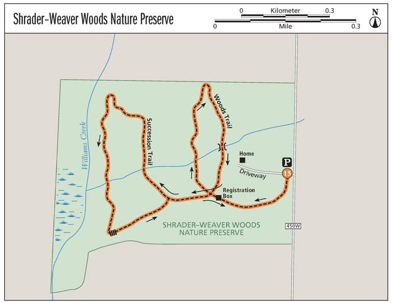
A108-acre preserve in the otherwise undistinguished farm country of northern Fayette County would be easy to overlook, or worse, dismiss. But Shrader–Weaver Woods Nature Preserve will not disappoint you. Shrader–Weaver Woods was established in 1973, when Lazarus and Edith Weaver donated 96 acres to the Nature Conservancy. The trail features two loops. The first loop, the Woods Trail, is known for its old-growth forest. The stillness and towering canopy have drawn many comparisons to a cathedral. The high cover blocks any direct light from the forest floor and the understory is limited to nettles and other knee-high plants, allowing for sweeping 360-degree views of the entire woods and all its venerable trees. It’s the kind of wide-open woodland scene you would expect in a Robin Hood movie. The second loop, the Succession Trail, is much more interesting than it sounds. It is known for an impressive springtime wildflower display along its beautiful wetland.
The hike starts from the parking lot and passes over a private drive that leads back to a caretaker’s home. The trailhead is just south of the private drive, and a 0.2-mile connector trail takes you to the beginning of the two loops. This junction features a registration box that at one point probably contained maps. It has fallen into disrepair, however, and appeared to have been vandalized with a shotgun when this book was researched.
Shown in the foreground is the trunk of one of the many towering black walnut trees credited with giving Shrader–Weaver Woods Nature Preserve a cathedral-like atmosphere.
Near the beginning of the Woods Trail, just after the first junction, a massive beech on the left and equally impressive tulip tree on the right give you a taste of what you are in for. At mile 0.3 you’ll cross a small stream on your way to the northern edge of the property. At mile 0.5 the trail curves back around to the east, along a slight bluff, and you’ll notice farmland in the distance. On the way back around to the south, pass over a bridge crossing the same stream as earlier, and then enter an area characterized by towering black walnuts. The Nature Conservancy describes these as “perhaps the best stand of old-growth black walnut anywhere in North America.” At mile 0.7 the Woods Trail ends and you carry on straight toward the Succession Trail loop.
The area along the Succession Trail was once grazed and is in the process of returning to forest. You’ll see mostly cherry, box elder, red maple, and buckeye, surrounded by a thick understory that includes, at times, invasive honeysuckle and multiflora rose. At mile 1.1, you’ll pass a massive bur oak, probably 6 feet in diameter, as the trail curves around to the left. A second massive bur oak is just ahead and both are undoubtedly relics, left to stand even as the trees around them fell to the ax. As you pass the oak trees, you’ll notice Williams Creek meandering slowly past swampy banks lined with skunk cabbage on your right. This lowland area is treasured for its wildflowers, and in the spring you are likely to notice everything from wild iris to Michigan lily, trillium, and swamp goldenrod.
At mile 1.4 a boardwalk passes over a wetland. The wetland has discouraged tree growth, allowing sunlight to flood in and further fuel the growth of flowers and sedges. After the boardwalk the trail climbs back to the upland area, and you’ll retrace your steps back to the parking lot.
MILES AND DIRECTIONS
0.0Start from the parking lot and walk south, crossing the driveway to the private residence to the trailhead on the other side.
0.2Stay straight through the four-way junction, following the directional marker that says BEGIN WOODS TRAIL. This will take you on a clockwise path along the Woods Trail.
0.7At the end of the Woods Trail, continue straight toward the Succession Trail.
0.8Stay straight past the junction that marks the beginning and end of the Succession Trail. This will take you on a counterclockwise path along the Succession Trail.
1.6After you complete the Succession Trail, retrace your steps back to the parking lot.
1.9Arrive back at the trailhead and parking lot.
HIKE INFORMATION
Local information: Connersville Tourism Board, 524 Central Ave., Connersville, IN 47331; www.tourconnersville.com
By some accounts, Shrader–Weaver is home to Indiana’s champion black walnut tree. But in Indiana’s 2010 Big Tree Register, that honor went to Milllersburg in Elkhart County. That tree, owned by Michael and Pamela Smith, is 18 feet around and 88 feet tall. But Fayette County is home to two champion trees. The state’s biggest butternut tree, at almost 19 feet around and 27 feet tall, and the biggest magnolia tree, at 17 feet around and 65 feet tall, are both near Connersville.


