18
Morgan-Monroe State Forest: Three Lakes Trail
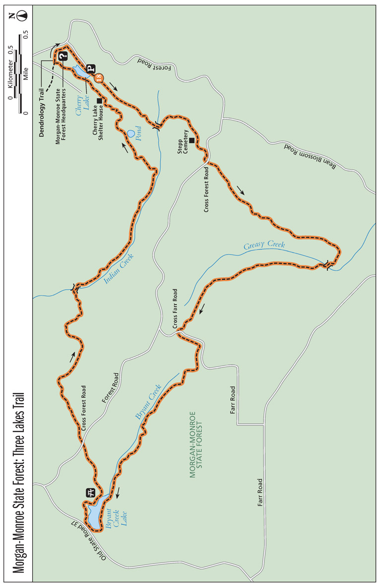
Three Lakes Trail is a bit of a misnomer. The 9.6-mile trail starts and ends at Cherry Lake and passes Bryant Creek Lake around halfway through. But the third lake, Bean Blossom Lake, is both dry and far enough off the trail that you won’t see it. In addition to the lakes, the hike skirts a cemetery some say is haunted and passes through sheltered hollows that offer a wildflower explosion in the spring.
Start: From the Three Lakes Trail trailhead near Cherry Lake, just west of the forest office
Distance: 9.6-mile loop
Hiking time: 4 to 5 hours
Difficulty: Difficult due to length and some hills
Trail surface: Mostly natural surface singletrack
Best season: Apr and May, when the woodland wildflowers are in bloom
Other trail users: None
Canine compatibility: Leashed dogs permitted
Fees and permits: None
Schedule: No hourly restrictions; open year-round
Maps: Morgan-Monroe State Forest brochure. DeLorme: Indiana Atlas & Gazetteer: Page 44 H4
Trail contact: Morgan-Monroe State Forest, 6220 Forest Rd., Martinsville, IN 46151; (765) 342-4026; www.in.gov/dnr/forestry/4816.htm
Special considerations: Take plenty of water and some food in preparation for traveling a long distance.
Finding the trailhead: From Martinsville, take IN 37 south about 5 miles. Turn left at the top of a hill onto Bryants Creek Road, when you see the signs for MORGAN-MONROE STATE FOREST. Follow Bryants Creek Road about 2 miles and then turn left onto Old State Road 37. Follow Old State Road 37 for about 0.6 mile to Forest Road and turn right. After 4.4 miles you will approach the forest office and turn left toward Cherry Lake. Parking is on your right along the lake. The trailhead is downhill, just past the lake on the left (east) side of the road. GPS: N39 19.342' / W86 25.402'
THE HIKE
The Three Lakes Trail is one of two long-distance trails in Morgan-Monroe State Forest. Like Low Gap (see Hike 17), Three Lakes traverses a demanding roller-coaster terrain that stretches along high ridgetops, drops down into five deep hollows, and crosses several streams. Hikers in April and May will experience forest floors carpeted in red, yellow, white, and purple wildflowers, including violets, bluets, red trillium, spring beauty, wood poppy, trout lily, and more.
The hike starts downhill and enters a hollow at around 0.4 mile, crisscrossing a creek before joining a sunken roadbed and climbing uphill to Stepp Cemetery at mile 1. Veterans of the Civil War and even the War of 1812 are buried here. But the real star of Stepp Cemetery is the “Lady in Black,” who is said to haunt the area in eternal mourning.
Beyond Stepp Cemetery the trail turns to singletrack again and weaves around the ridgetop before crossing the Forest Road around mile 1.2 and merging with what looks like an old roadbed on the other side. The hike continues down Precinct Ridge, a high, narrow ridge covered in oak trees and greenbrier with a sprinkling of immature tulip poplar.
The trail eventually winds downhill, negotiating a series of switchbacks, into another hollow at 2.4 miles. When you cross Greasy Creek, you are about 0.25 mile from the dry Beanblossom Lake to the south. No sooner do you cross the creek than you start climbing again, up another set of switchbacks and eventually merging with a power-line corridor along Ira Hacker Ridge. At mile 2.9 the power-line corridor turns sharply to the right, and the trail continues straight, back under the canopy of the forest following another old ridgetop roadbed.
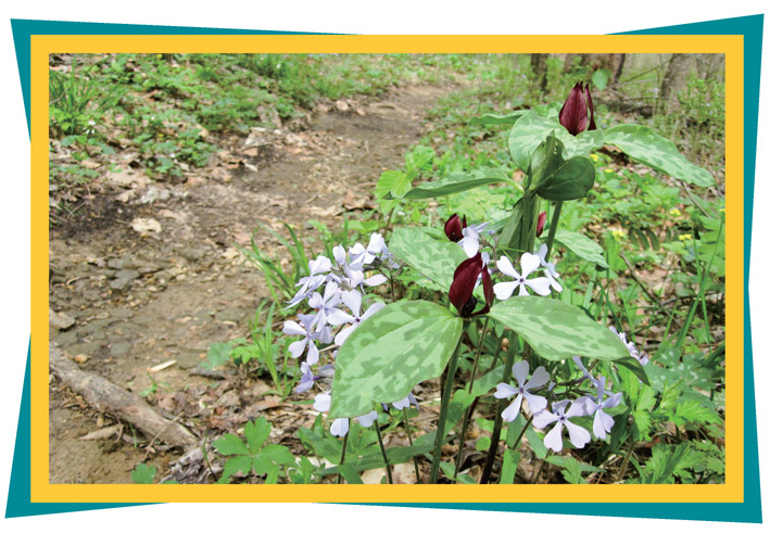
Red trillium and phlox create a natural bouquet along Three Lakes Trail.
At mile 3.6 you will pass over Farr Road, a gravel service road. Continue straight on the singletrack trail on the other side. The trail weaves through the upland woods before dropping into another hollow around 4.2 miles. Cross Bryant Creek several times, and climb over a long, stone wall before coming to Bryant Creek Lake at around mile 5. The trail navigates the lake’s high south shoreline, crosses over the dam, and eventually climbs away from the lake and past a picnic area and shelter house. Look for the white diamond trail blazes to navigate through the picnic area and back into the woods. The trail wraps around to the marshy, eastern end of the lake once again before turning uphill. You will climb until you reach Forest Road again around mile 6.
After crossing Forest Road, the trail descends into a fourth hollow via another series of switchbacks and crosses Indian Creek. Much like the second hollow, the trail doesn’t stay at creek elevation for long before climbing up another series of switchbacks to yet another ridgetop.
A black rat snake slithers through leaves on a hillside along the Three Lakes Trail.
At 6.7 miles you’ll come to a small clearing where a small mountain of abandoned timber has been pushed to the side. Follow the trail to the left, downhill into the Indian Creek valley again at 7 miles. The trail runs between a hollow-bottom pine plantation to the right and a clear-cut hillside, which has been logged in recent years, to the left. Follow the banks of Indian Creek for about 1 mile before turning left, up out of the hollow.
At 9 miles you will pass the Cherry Lake shelter house as the trail opens onto the Cherry Lake dam. You have two options: You can turn right and follow the dam back to the trailhead parking area, or you can continue around the western edge of the lake along the Dendrology Trail, named for the science of tree identification. The Dendrology Trail is not well marked, and in recent years downed trees have made it hard to follow. Pick your way through the woods to the back end of the lake and beyond.
At 9.4 miles the trail comes to a T at a gravel path. Turn right and follow the gravel path out to the forest office, where you will briefly join Forest Road, then turn right again down the road to the Cherry Lake parking area.
The direction a slope faces, its aspect, plays an influential role in the slope’s climate and flora. North-facing slopes tend to be shadier, cooler, and wetter than south-facing slopes. Oaks, cedars, sedges, blueberry, and huckleberry prefer south-facing slopes. Beeches, maples, redbuds, and poison ivy prefer the north.
Haunted Stepp Cemetery
Stepp Cemetery is a favorite among Indiana ghost hunters, so as you pass be on the lookout for the ghostly “Lady in Black,” a woman said to haunt the cemetery and surrounding forest. One of many variations of the Lady in Black legend says that the ghost sightings started in the 1950s, when people began reporting a lady shrouded in black hovering over a stone marked BABY LESTER. According to this version, the Lady in Black is the ghost of a woman who lost her child in the 1930s. Others say her name was Anna, and that she mourns the deaths of her husband and teenage daughter. Another local legend says the cemetery was used by a religious cult called the “Crabbites” for bizarre rituals. There is little evidence, however, that the Crabbites actually existed.
MILES AND DIRECTIONS
0.0Start at the Three Lakes trailhead, located across the forest road from Cherry Lake.
1.0Pass Stepp Cemetery.
1.2Cross Forest Road.
2.4Cross Greasy Creek.
3.6Cross Farr Road, where the trail switches from an old roadbed to singletrack.
5.4Cross the Bryant Creek Lake dam.
5.5Follow the white diamond blazes through the picnic area.
5.7At the marshy, back end of Bryants Creek Lake, follow the trail to the left and uphill.
6.1Cross Forest Road again.
8.1Turn left out of the hollow along Indian Creek and head uphill.
8.9Follow white diamond markers around the Cherry Lake shelter house and back into the woods.
9.0Cross the Cherry Lake dam and continue north into the woods. (Option:Turn right along the dam to return to the parking area.)
9.3Turn right onto the Dendrology Trail, following it out to the forest office.
9.4Pass the forest office and join Forest Road. Then turn right on the road to Cherry Lake.
9.6Arrive back at the trailhead.
HIKE INFORMATION
Camping: Primitive camping is available at Morgan-Monroe State Forest for a fee. Campers must register at the forest office. The Mason Ridge Campground, behind the fire tower and north of the office, has vault toilets and seasonal drinking water. Overflow camping is available at Oak Ridge Campground. Camping is also permitted in the Back Country Area. Camping in state forests is first come first served and reservations are not taken. Camping information is available at the Morgan-Monroe State Forest Headquarters, 6220 Forest Rd., Martinsville, IN 46151; (765) 342-4026; www.in.gov/dnr/forestry/4816.htm.


