44
Turkey Run State Park: Rocky Hollow–Falls Canyon
The very best hike in this guide has been saved for last. You’ll fall in love with this trek within the first 0.5 mile, when you turn into Rocky Hollow, a narrow gorge flanked by high walls of moss-covered Mansfield sandstone and capped by a canopy of eastern hemlock trees, through the branches of which sunlight filters onto the hollow floor below. The experience is like no other in central Indiana and should not be overlooked. This adventurous hike passes through pristine old-growth forests and an impressive lineup of natural landmarks, including Wedge Rock, the Punch Bowl, Camel’s Back, Bear Hollow, Boulder Canyon, Falls Canyon, the Ice Box, and Crevice Rock. Start: From the nature center
Distance: 4.5-mile lollipop with double loops
Hiking time: 3 to 3.5 hours
Difficulty: Difficult due to length, hills, and rocky, uneven terrain
Trail surface: Natural surface singletrack, canyon bottom creek beds, and some gravel
Best season: Apr and May, when the woodland wildflowers are in bloom and the waterfalls are active
Other trail users: None
Canine compatibility: Leashed dogs permitted but not suggested, given rugged terrain and ladder climbs
Fees and permits: Entrance fee charged
Schedule: Open daily from 7 a.m. to 11 p.m., year-round
Maps: Park map available at the gatehouse and the nature center. DeLorme: Indiana Atlas & Gazetteer: Page 37 G7
Trail contact: Turkey Run State Park, 8121 East Park Rd., Marshall, IN 47859; (765) 597-2635; www.in.gov/dnr/parklake/2964.htm
Special considerations: Use extreme caution around the cliffs, especially after rains when the sandstone is slick.
Finding the trailhead: From I-74 near Crawfordsville, take exit 39 and turn left onto westbound IN 32. Travel 4.9 miles to downtown Crawfordsville and turn left at Washington Street. After 1.2 miles turn right onto IN 47, also known as South Boulevard. Follow IN 47 for 22 miles to the Turkey Run State Park entrance on your right. Follow the signs to the nature center. GPS: N39 53.248' / W87 11.999'
THE HIKE
Before you set out on this hike, understand that the terrain is among the most rugged in Indiana. After heavy rains Rocky Hollow and the canyons will be muddy at best and impassable at worst. Wet weather will also make the sandstone cliffs and canyons especially slick—and even dangerous. You should take special cautions to prevent a fall.
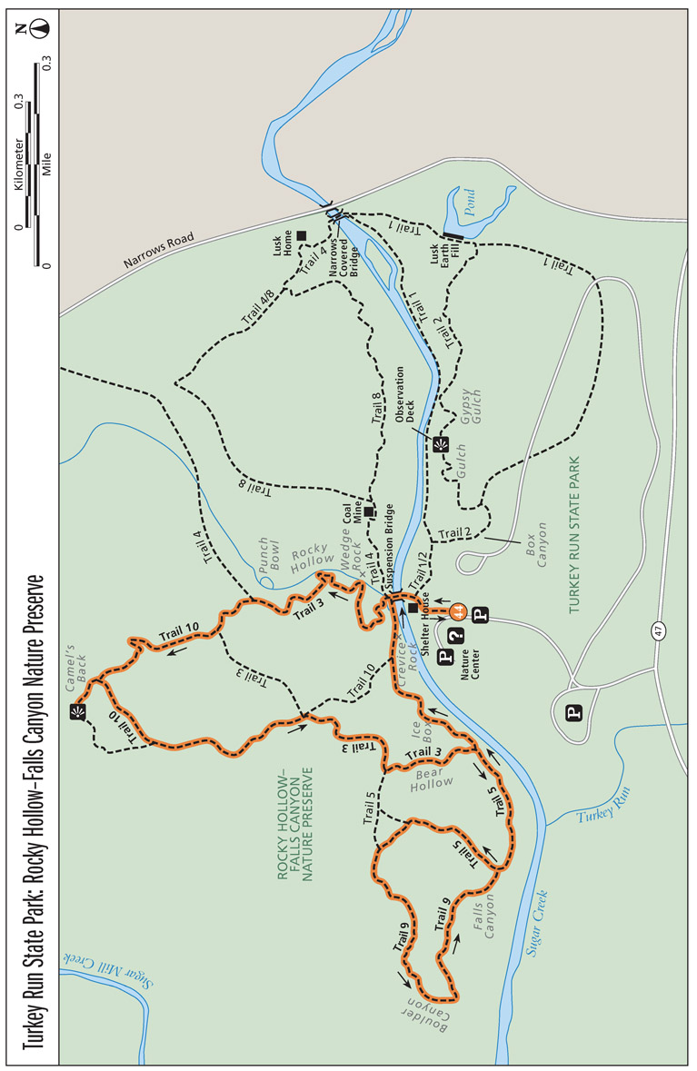
Like Turkey Run’s Eastern Loop (see Hike 43), the Rocky Hollow–Falls Canyon hike starts at the Turkey Run State Park nature center and combines segments of a handful of park trails. Follow the gravel path behind the nature center, around the shelter house, down a flight of stone stairs, and then cross over Sugar Creek on the pedestrian suspension bridge. When you cross the bridge you enter the 1,600-acre Rocky Hollow–Falls Canyon Nature Preserve. The northern half of the Eastern Loop also passes through the nature preserve, but the preserve’s best features and landmarks are reserved for this hike.
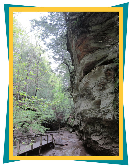
A forbidding cliff greets hikers walking on a boardwalk at the entrance of Rocky Hollow.
After the suspension bridge, you’ll head into Rocky Hollow on Trail 3. The gorge has its own microclimate, which is similar to a time 12,000 years ago when the glaciers had retreated and conditions in Indiana were cooler, without dramatic seasonal temperature changes. The hemlock forests that covered Indiana in that long-ago time remain in Turkey Run to this day, isolated relicts of a northern forest that has mostly retreated to Michigan, Wisconsin, and Minnesota, making room for today’s central hardwood forest.
At 0.5 mile you will pass Wedge Rock. The massive rock was once the ledge at the top of the canyon. Water seeped into cracks in the rock, freezing and expanding. Eventually the rock broke free and crashed to the canyon floor.
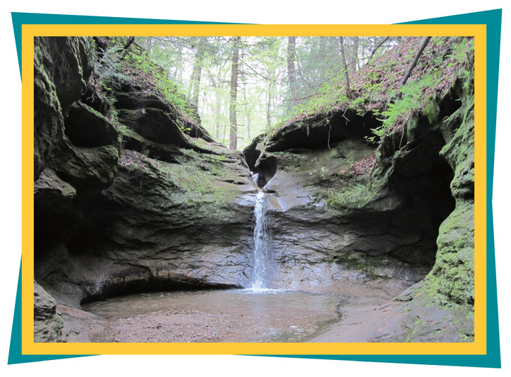
After another 0.25 mile, the canyon bottlenecks into a narrow crevice with a floor of slippery, terraced bedrock, then opens up into the Punch Bowl. The Punch Bowl was created when pieces of rock became caught in a swirling backwash of glacial meltwater, scouring out a large pothole and leaving behind a waterfall.
Stay straight on Trail 3 past the Punch Bowl and continue up the canyon. At about the 1-mile mark, you’ll climb a set of stairs out of the head of the canyon, where you will turn right onto a Trail 10 connector. At mile 1.4, take another right onto the Trail 10 spur to Camel’s Back, where an observation deck and sitting bench offer a ridgetop view of the Sugar Mill Creek valley.
Water falls into the Punch Bowl, a geological feature scoured out of the bedrock by glacial erratics caught in a backwash of glacial runoff.
From the Camel’s Back, retrace your steps and continue south on Trail 10. Stay right at the intersection with the Trail 10 connector and continue south. When you reach a four-way intersection with Trail 3 at 2 miles, turn right onto Trail 3, following the trail down a set of stairs.
At mile 2.2 you will come to a set of three ladders that drop into Bear Hollow. The name traces back to a time when Indiana still had bears and a hunter encountered one at the mouth of this canyon. A violent and lengthy fight ensued and the hunter eventually shot the bear. Take special precaution here, as the sandstone ledges that overlook Bear Hollow at the ladders are sloped and often slick, and a slip of the foot could plunge you to the canyon bottom 50 feet below. At the end of Bear Hollow, turn right onto Trail 5, following it along Sugar Creek. Around 2.6 miles, follow Trail 5 to the right at a junction with Trail 9. This marks the beginning of the second loop. Head up a set of stairs, away from the creek and into the uplands. Trail 5 eventually merges into Trail 9 on a counterclockwise loop toward Boulder Canyon. The route passes under a tall canopy formed by an old-growth forest of massive hardwoods.
At about 3.2 miles Trail 9 drops down into Boulder Canyon, so named for the massive boulder field that covers the descent to the canyon bottom. The boulders originated in Canada, were captured in glaciers, and then were deposited here at the end of the ice age. Called erratics, it’s these same types of glacial stones that were responsible for scouring the Punch Bowl pothole on Trail 3.
When you reach the canyon floor, look to your left, where a waterfall drops over the rim, cutting a U-shape into a stone overhang. After Boulder Canyon, you’ll climb over a ridge and drop into Falls Canyon. From Falls Canyon, follow Trail 5 about 0.5 mile along Sugar Creek to the suspension bridge, passing the Ice Box and Crevice Rock formations. A sandstone gorge on the banks of Sugar Creek, Ice Box provides shelter from the sun and elements. At one time a gang of thieves would store butchered hogs here until they had enough to load a flatboat for markets downstream. Crevice Rock is noteworthy for the large staircase that winds up a large crack in the formation. From the bridge, retrace your steps to the trailhead.
MILES AND DIRECTIONS
0.0Start at the nature center and head north toward Sugar Creek.
0.2Cross Sugar Creek on the pedestrian suspension bridge.
0.3Turn right onto Trail 3, crossing a small footbridge into Rocky Hollow.
1.0Stay straight on Trail 3 at the junction with Trail 4, which is located beyond the Punch Bowl.
1.1After you climb the stairs out of Rocky Hollow, turn right onto a Trail 10 connector.
1.4Where the Trail 10 connector comes to a T at the gravel Trail 10, turn right on a spur to Camel’s Back.
1.5Reach the Camel’s Back, then turn around and continue on the gravel Trail 10 heading south.
2.0At a small clearing in the woods, Trails 10 and 3 meet at a four-way intersection. Turn right onto Trail 3 and head downhill.
2.2Head down the ladders into Bear Hollow and travel past the intersection with Trail 5. (Caution: Be very careful and watch your step as you descend into Bear Hollow. Don’t get too close to the edges of the sandstone ledges.)
2.4At the end of Bear Hollow, turn right onto Trail 5.
2.6At the junction with Trail 9, turn right to continue on Trail 5, following it uphill.
2.9Stay straight past back-to-back trail junctions on the right. Trail 5 becomes Trail 9 here.
3.7At the end of Falls Canyon, follow Trail 5 along Sugar Creek back toward the suspension bridge.
4.1Pass the Ice Box.
4.3Pass Crevice Rock. Cross the suspension bridge toward the trailhead.
4.5Arrive back at the trailhead.
HIKE INFORMATION
Local information: Parke County Convention and Visitors Commission, P.O. Box 165, Rockville, IN 47872; (765) 569-5226; www.coveredbridges.com
Local events: Parke County Covered Bridge Festival, celebrated countywide; (765) 569-5226; www.coveredbridges.com. This festival, which organizers say is the largest in the state, highlights Parke County’s thirty-one covered bridges. The festival headquarters is at the Parke County Courthouse in Rockville.
Camping: Turkey Run State Park offers 213 sites with electrical hookups at a campground with flush toilets, hot water, and showers. Reservations are available through the central reservation system at www.camp.in.gov.


