4 McKinney Roughs Nature Park: Buckeye Trail
It’s always great to find a new trail, such as the Buckeye Trail in McKinney Roughs Nature Park qualifies, which opened in late 2007. This is really a connector trail between the Road Runner Trail and the Pecan Bottom Trail, making those trails easier to reach. Buckeye Trail passes through the post oak/blackjack oak savanna ecosystem and leads to one of the largest pecan trees in the state.
Distance: 3-mile loop
Approximate hiking time: 1.5 hours
Trail surface: Dirt path, sand
Best season: September to June
Other trail users: Equestrians, dog walkers
Canine compatibility: Leashed dogs permitted
Land status: Lower Colorado River Authority park
Fees and permits: Check in at the visitor center before hiking to pay the day-use fee and get a trail map and information. Fee includes the opportunity to borrow one of three nature packs: Birding Pack, with binoculars and guidebook; Plant Pack, with magnifying glass and explanation of what plants to look for; Kid Pack, with bug containers and children’s books describing the plants, birds, and insects found at the park.
Schedule: 8:00 a.m. to 5:00 p.m. daily; day use only
Maps: Trail maps are available in the park office and also on the Web site www.lcra.org/library/media/public/docs/community_mck_roughs_trailmap.pdf. NCGS topo: Utley, 7.5' quad
Trail contacts: McKinney Roughs Nature Park, 1884 TX 71 West, Cedar Creek 78612; (512) 303-5073
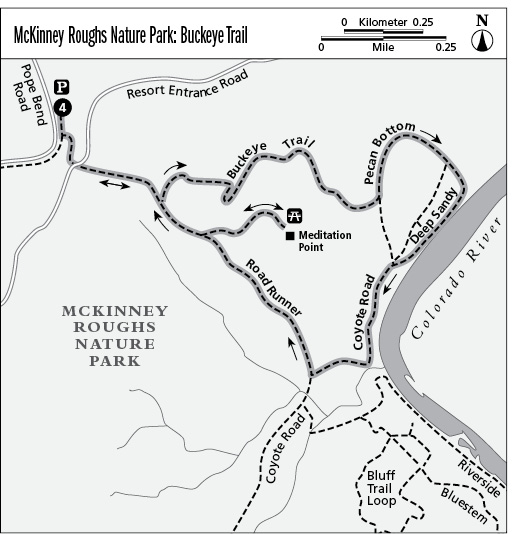
Finding the trailhead: From Austin, head east on TX 71 past Austin-Bergstrom International Airport. Proceed for about 13 miles beyond the airport and look for the park’s rock-wall entrance with a windmill on the left (north). Hikers should check in at the Lower Colorado River Authority (LCRA) office near the main parking area. The Buckeye trailhead is located at the Pope Bend Equestrian Trail parking area, across the road leading to the Hyatt Regency Resort. From park headquarters, drive to the park entrance and turn right (northwest) onto TX 71, continue less than a mile, and turn right (north) onto Pope Bend Road. Proceed for about a mile to the Pope Bend Equestrian Trailhead parking lot, on your right. DeLorme: Texas Atlas & Gazetteer: Page 69 G11. GPS: N30 92.700' / W97 27.484'
The Hike
This hike combines sections of the Buckeye, Road Runner, Coyote Road, Deep Sandy, and Pecan Bottom Trails. Legend has it that bandits used this remote area as a hideout. Start at the Pope Bend Equestrian Trailhead on the northwest side of McKinney Roughs Nature Park.
Follow the Road Runner Trail to the Buckeye Trail and turn left. Enter the woods, which contain several species of oak trees and are part of the post oak savanna ecosystem. Bear east on the Buckeye Trail, passing a box canyon to the right. The trail is shared by equestrians, so use caution.
A visual feast of wildflowers greets the hiker along many trails. During May, the woods are full of North America’s prettiest birds, the warblers. Seeing a flock of these, containing several species and hundreds of birds, is spectacular. One of the more conspicuous is the yellow warbler, which is the only all-yellow warbler, making it easy to spot and identify.
The Buckeye Trail descends until it ends at an intersection with the Pecan Bottom Trail. After making a sweeping right bend and heading southeast, you will see a huge pecan tree. It’s impressive and it would probably take three men with outstretched arms to circle the trunk. There is a picnic table located nearby where you can rest in the shade. Continue on down toward the Colorado River, passing Coyote Road on the right. Pecan Bottom ends as it merges into Deep Sandy Trail. Bear southwest, walking along the river, where the scenery is totally different from that of the uplands. The forest has been replaced by the river’s flat bottomland and lush growth of bushes and grasses. The river’s edge is a good place to look for animal signs, including tracks. After about one-third of a mile, Deep Sandy Trail ends where it merges into Coyote Road. Take the left branch, heading south along the river’s edge. Watch for poison ivy. Bend right and head away from the river. At the intersection with Road Runner Trail, turn right and head up into the woods. Look to the left to see some small peaky hills, which are called knobs. The most famous knob in the area is Pilot Knob, the remains of an extinct volcano. Take the spur on the right to a scenic overlook called Meditation Point. The panorama includes a box canyon and the best view of the Colorado River in the park. There are picnic tables, and this is a nice place to rest or have a snack. Return to the Road Runner Trail, go past the branch with the Buckeye Trail, and then backtrack to the trailhead.
Miles and Directions
0.0Start at the Road Runner trailhead, following the Road Runner Trail to the Buckeye Trail.
0.1Pass the intersection (actually less than 100 yards) with the Yaupon Trail on the right (Yaupon Trail heads south). Continue straight, heading east on the Road Runner Trail. The Buckeye connector trail intersects the Road Runner Trail on the left (northeast). Turn left onto the Buckeye Trail, following the contours of the hills.
0.6The Buckeye Trail ends at the Pecan Bottom Trail. Turn left, heading north and walking in the Colorado River lowlands.
0.9Pass Coyote Road on the right (south) where it intersects the Pecan Bottom Trail.
1.0Pecan Bottom Trail merges into the Deep Sandy connector to Coyote Road.
1.3Deep Sandy Trail merges into Coyote Road. Continue left, heading south on Coyote Road, with the Colorado River on the left (east). Also at this junction, Coyote Road runs north and south, and the Pecan Bottom Trail connects to Coyote Road from the right (north).
1.8Travel close to the river. Make a right turn, heading west and away from the river bottomland, and begin to climb the slopes. Come to a junction with the Road Runner Trail. Turn right (northwest) onto the Road Runner Trail. Coyote Road continues southwest.
2.3There is a spur on the right (northeast) that leads to Meditation Point. Take the spur. This leads to an overlook that furnishes the best view in the park of the Colorado River. Several picnic benches are located here. Backtrack to the Road Runner Trail.
2.8Turn right (northwest) where the spur intersects the Road Runner Trail.
2.9Pass the intersection on the right (northeast) where the Buckeye connector trail joins the Road Runner Trail. Continue west, backtracking on the Road Runner Trail to the trailhead.
3.0Arrive back at the trailhead.